


Moving Borders with QGIS | Aten Design Group
▻http://atendesigngroup.com/blog/moving-borders-qgis
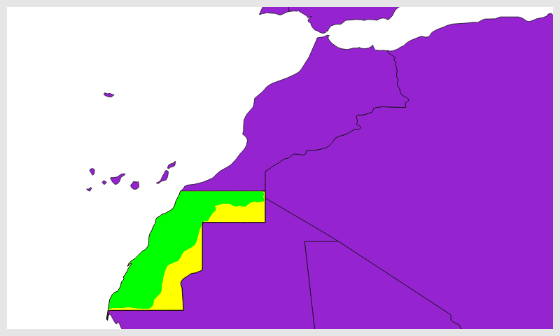
the Sahrawi Arab Democratic Republic (SADR) which is currently recognized by 84 UN member states claims approximately the southern half of this area.

? — fil@rezo.net — ►https://twitter.com/recifs — ►https://rezo.net — ►https://visionscarto.net — https://vis.social/@fil
Moving Borders with QGIS | Aten Design Group
▻http://atendesigngroup.com/blog/moving-borders-qgis
the Sahrawi Arab Democratic Republic (SADR) which is currently recognized by 84 UN member states claims approximately the southern half of this area.

Natural Earth Vector draws boundaries of sovereign states according to defacto status. We show who actually controls the situation on the ground. For instance, we show China and Taiwan as two separate states. But we show Palestine as part of Israel. Please feel free to mashup our countries and disputed areas themes to match your particular political outlook.
▻http://www.naturalearthdata.com/downloads/10m-cultural-vectors/10m-admin-0-details
▻http://www.naturalearthdata.com/forums/topic/disputed-territories-type-field
bon alors, j’ai suivi le tuto, mais malheureusement ça ne marche qu’à moitié : j’ai bien la « frontière » entre MAR et SAH, mais la topologie de la frontière entre SAH et MRT n’est pas bonne…en fait je suis pas certain que ce soit le bon outil
à suivre
PS : ça y est j’ai fini par trouver une procédure adéquate.
Natural Earth et la frontière Maroc-Algérie c’est aussi un peu approximatif … ci-dessous la différence entre les versions 110m et 50m du fichier admin_0_countries :

