public-apis/public-apis: A collective list of free APIs for use in software and web development.
▻https://github.com/public-apis/public-apis
A collective list of free APIs for use in software and web development.
Pas mal de #geocoder référencés.
public-apis/public-apis: A collective list of free APIs for use in software and web development.
▻https://github.com/public-apis/public-apis
A collective list of free APIs for use in software and web development.
Pas mal de #geocoder référencés.
Which #geocoder should I use ?
▻http://getlon.lat
↑ trop classe ce domaine :)
Geocoding service APIs from dozens of different providers analysed to help you choose.
#map


Récupérer le département ou le pays d’une adresse » Google Map V3
▻http://www.weboblog.fr/recuperer-departement-et-pays-google-map
Le service de geocodage : geocoder de l’api Google Map permet de récupérer les coordonnées d’une adresse ou inversement, une adresse à partir de ses coordonnées.
La réponse retournée par l’api contient plusieurs informations comme par exemple le code postal, la région, le département ou encore le pays (exemple de retour Json google Map).
Donne un exemple de code pour la fonction de #géocodage_inversé et son retour Json
@b_b :y aurait il moyen de faire la même chose avec du OSM ?
...et la réponse est oui :-) : ▻http://wiki.openstreetmap.org/wiki/Nominatim#Reverse_Geocoding
avec de la doc sur ▻https://developer.mapquest.com/documentation/open/nominatim-search
et sur le même sujet, voir aussi : ►https://geocode.localfocus.nl (cf ▻https://seenthis.net/messages/689940)
#geocoder #cartographie #adresse #api #googleMap #json #ville #géolocalisation

Avec Geoportail aussi si mes souvenirs sont bons.
oui, on le fait dans GIS en tapant sur nominatim ou photon qui utilisent tous les deux les données #osm cf :
▻https://zone.spip.org/trac/spip-zone/browser/_plugins_/gis/trunk/action/gis_geocoder_rechercher.php
Sinon, tu peux aussi taper dans #bano pour ça, cf :

voici 2 fonctions gis_info_coordonnees et texte_info_coordonnees qui renvoient les infos reverse concernant des coordonnées lon et lat, sous format tableau php utilisable selon les besoins et sous forme de texte directement affichable : ▻https://contrib.spip.net/Astuces-GIS#gis_info_coordonnees
Par exemple ça renvoie Le Sablard, Limoges, Haute-Vienne, Nouvelle-Aquitaine, France métropolitaine, 87036, France

@passerelle merci pour la contrib dans le wiki, juste une remarque : pourquoi tu dupliques le code de action_gis_geocoder_rechercher_dist() au lieu de l’utiliser directement ?
Il n’y a que la dernière ligne qui est intéressante dans action_gis_geocoder_rechercher_dist. Le reste est une manière, inadéquate ici, de récupérer les arguments ou de changer le header http.
#OSMNames open-source project which provides a basic place search / geocoding functionality. It is a lightweight search system powered by full-text engine with world-wide coverage. At the moment it is limited to place names like streets, towns, cities, administrative units, countries, etc.. It can be extended in future with other place types like lake or mountain names and even with POIs. The enhancement with postal addresses (house numbers and zip codes) is also possible.
The core of the OSMNames project is the pre-processed data. It comes in easy to handle text format, the #TSV (tab separated value). This allows filtering with UNIX text processing tools (grep, sed, awk, less, cut, etc.) and direct indexing via a full-text search engine.
The project comes with an open-source server software providing a place search API suitable for a basic #geocoder with autocomplete functionality. The server is written in Python and is powered by the high-performance C++ open-source full-text engine called #Sphinx Search.
Here you can download the pre-generated data with over 21 million place names for the whole planet.
The open-source code for generating the data is available in the repository ▻https://github.com/osmnames/osmnames
The Place Search API used in this website is implemented with the open-source project available at ▻https://github.com/klokantech/osmnames-sphinxsearch

Nouvelle Aquitaine => rien
Occitanie => rien
:)
Tour Eiffel => premier résultat, Tunis
mmmh c’est pas encore au point leur truc :p
Ce qui suit explique certainement pourquoi tu ne trouves pas la Tour Eiffel...
This initial release of OSMNames project provides only place names for a basic search of street names, towns, cities and other administrative units. It can be extended in future with other place types like lake or mountain names and even with POIs.
Ah oui ok il me semblait avec lu qu’il y avait les POI justement, j’avais dû lire de travers à toute vitesse… :p
five-minute #geocoder for openaddresses (tecznotes)
▻http://mike.teczno.com/notes/openaddr/5min-geocoder.html
Start with a clean server running a current version of #ubuntu LTS (long-term support); either 14.04 or 16.04 will work. Amazon has readymade Ubuntu images available on EC2, or a local copy running under Virtualbox will do for testing. Both the address import process and the Elasticsearch index are hungry for lots of memory, so pick a server with 4-8GB of memory to prevent failures.
Inside #Libpostal - a fast, multilingual, international street address parser trained on OpenStreetMap data · Mapzen
▻https://mapzen.com/blog/inside-libpostal
▻https://github.com/openvenues/libpostal
#nlp #machine_learning #text-mining #geocoding #géolocalisation #cli #outils
As a motivating example, consider the following two equivalent ways to write a particular Manhattan street address with varying conventions and degrees of verbosity:
> 30 W 26th St Fl #7
> 30 West Twenty-sixth Street Floor Number 7
Obviously ’30 W 26th St Fl #7 != ’30 West Twenty-sixth Street Floor Number 7’ in a string comparison sense, but a human can grok that these two addresses refer to the same physical location.
sur le même sujet : ▻http://seenthis.net/messages/399075

We are happy to announce that access to the Libpostal address parsing and expansion services are now available via the Mapzen #API.
curl -s 'https://libpostal.mapzen.com/parse?address=475+Sansome+St+San+Francisco+CA&format=keys' | python -mjson.tool

{

   "city": [

       "san francisco"

   ],

   "house_number": [

       "475"

   ],

   "road": [

       "sansome st"

   ],

   "state": [

       "ca"

   ]

}▻https://github.com/whosonfirst/go-whosonfirst-libpostal/blob/master/docs/index.md
Happy holiday geocoding !
▻http://holidaysearch.mapzen.com
Santa noticed a good number of his favorite boys and girls have asked for a batch #geocoder this year. So he has commissioned a few of his more peculiar develop-elves to whip something up to bring joy to all those odd boys and girls. Hey, the big guy doesn’t judge!So, Santa’s gonna need a #csv formatted file with a column labeled “address”, and you’ll get back that same csv file but with “lat” "lng" columns!
#map
OpenCageData/address-formatting · GitHub
▻https://github.com/OpenCageData/address-formatting
This repository contains templates for various #address formats used in territories around the world. It also contains test cases.The intended use-case is database or geocoding systems (forward, reverse, autocomplete) where we know both the country of the address and the language of the user/reader. The address is displayed to a consumer (for example in an app) and not used to print on an envelope for actual postal delivery. We use it to format output from the OpenCage #geocoder . Our goal with this repository is a series of (programming) language independent templates. Those templates can then be processed by whatever software you (...)
Mise en place et utilisation d’un serveur BAN/BANO pour un usage personnalisé sous Ubuntu 14.04
▻http://geotribu.net/node/811
Dans une deuxième temps, nous introduisons la Base Adresse Nationale (BAN) et la Base Adresse Nationale Ouverte (BANO, historique). En effet, danc ce contexte, des outils pour géocoder ont été mis en oeuvre. Nous expliquerons comment les utiliser, comment installer un serveur pour géocoder chez vous si par exemple, vous avez des besoins de géocodage massif ou de personnaliser la recherche d’adresse avec vos critères lors du géocodage.
Setting up a Pelias Instance
▻https://mapzen.com/blog/pelias-setup-tutorial
Pelias is a modular open-source #geocoder using ElasticSearch for fast autocomplete and forward and reverse geocoding. It’s designed to support a variety of datasets, including #Geonames, Quattroshapes, #osm, and whatever else you can throw at it. Take a look at the demo to see what it can do right now and check out the work we’re currently doing on Github.
#map
OpenAddresses
▻http://openaddresses.io
The free and open global address collection. Released under a CC0 License.

Comparez les résultats de cinq géocodeurs d’adresses Françaises :
▻http://www.ideeslibres.org/GeoCheck/#q=53%20Avenue%20Gambetta,%20courbevoie
#cartographie #géocodage #France #BANO #IGN #Openstreetmap #Google
Photon, Apache-licensed search-as-you-type #geocoder based on #OpenStreetMap:
►http://photon.komoot.de
Pour info il existe un plugin pour #leaflet par ici :
Photon, search-as-you-type with OpenStreetMap
►http://photon.komoot.de
Search as you type with OpenStreetMap. Made with #osm, #opensource, powered by #elasticsearch
#cartographie #map même si ça pourrait éventuellement s’utiliser sans carte
tmcw/geocodify
▻https://github.com/tmcw/geocodify
Geocode streaming CSV data, producing CSV or GeoJSON.
geocodify input.csv > output.csv
Sources can be : mapbox, census, mapquestopen, twofishes, geogratis
Je le mixe avec q et c’est pas mal, à condition de bien indiquer select (champ d'adresse) as address et de faire très attention aux virgules :
q -H -O -d, -T "select AdressePostale as address from Database.csv where AdressePostale like '%Vendôme%' limit 5" | tr ',' ' ' | tr "\t" ',' | geocodify --source=mapquestopen ( #q : ►https://github.com/harelba/q )
Using #openrefine to geocode your data with Google and OpenStreetMap API | Opensas blog
▻http://opensas.wordpress.com/2013/06/30/using-openrefine-to-geocode-your-data-using-google-and-openstreet
In this article we will see how to use OpenRefine to enrich our datasets with data from any web service available on line. We will geocode each contact using google maps web service. For each address we will get the whole json response and we will learn to parse it, extract the coordinates, and save them in a latitude and longitude columns.
Sympa, simple à utiliser. Testé sur une liste de 8616 adresses gécodées avec #nominatim en 3h40min.
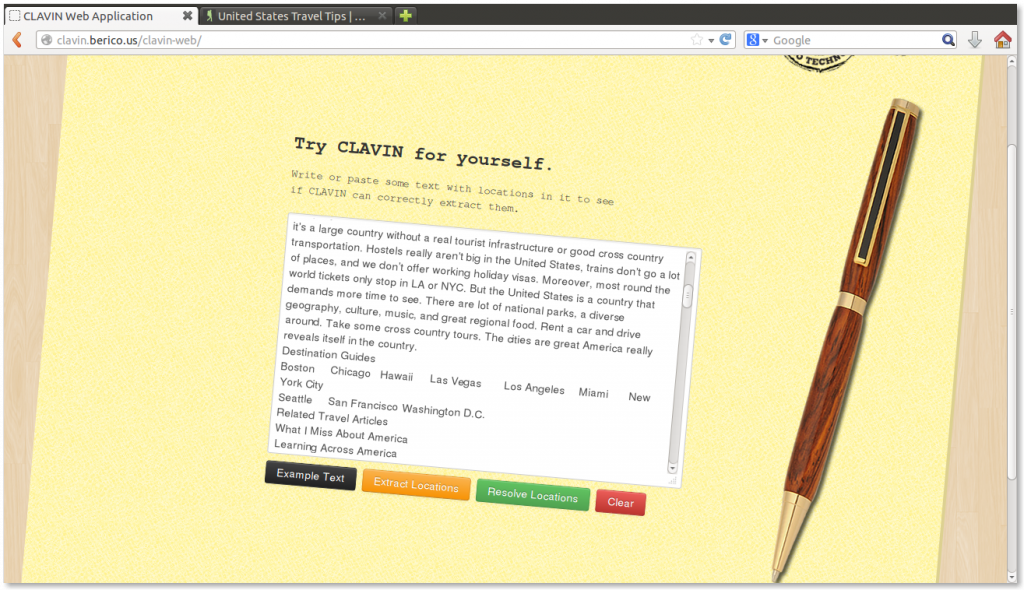
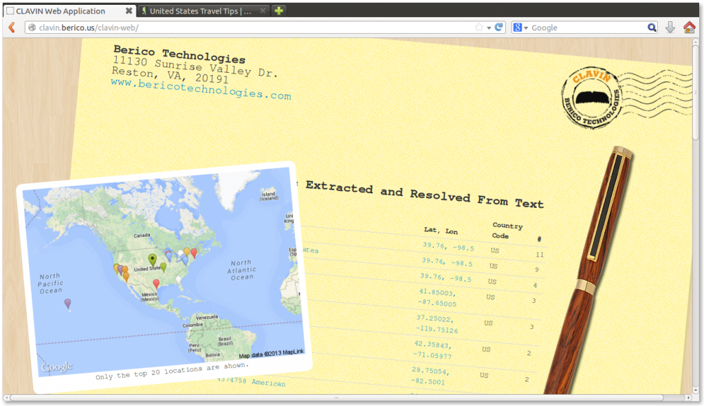
CLAVIN – open source context-based geotagging : digital-geography.com
▻http://www.digital-geography.com/clavin-open-source-context-based-geotagging
In fact the engine extracts locations out of structured and unstructured text documents and presents geographic features with meta data. CLAVIN does the geocoding with help of a gazetteer but goes a step further. It uses “intelligent heuristics” to find out the right results in combination with a fuzzy search to handle with different spellings of a location.
Les données viennent de #GeoNames et sont livrées sous forme de librairie Java :
▻http://clavin.bericotechnologies.com/site/documentation/geospatial-data-model.html
Basé sur Apache OpenNLP NameFinder pour trouver les occurrences de noms de lieux dans le texte, et sur #Apache #Lucene pour associer ces noms de lieux aux géométries (entrées de geonames). À noter que ce sont deux implémentations des interfaces LocationExtractor et LocationResolver, ce qui permet aussi de proposer des modules alternatifs pour les mêmes tâches.
Un bien intéressant projet.
#geocoder | Geocoder - The almost missing Geocoder #php library!
▻http://geocoder-php.org/Geocoder/#!
Geocoder is a library which helps you build geo-aware applications. It provides an abstraction layer for geocoding manipulations. The library is split in two parts: HttpAdapter and Provider and is really extensible.
Ah yes ! Avec un très grand nombre de fournisseurs déjà disponibles !
On peut donc ensuite imaginer que GIS encapsule ça dans une action SPIP. Et que le géocodeur JS d’aide à la saisie appelle l’action SPIP, qui appelle la librairie incluse, qui appelle le fournisseur configuré dans l’interface.
Du coup pas besoin de coder plusieurs géocodeurs dans plusieurs langages. On utilise le PHP comme base centrale, et le JS appelle le PHP. Et hop.
mapbox/carmen
▻https://github.com/mapbox/carmen
UTFGrid/#mbtiles-based #geocoder with support for swappable data sources
#map
geocoding addresses directly in #libreoffice Calc : digital-geography.com
▻http://www.digital-geography.com/geocoding-addresses-directly-in-libreoffice-calc
In a recent post I’ve described a way to geocode in a Google Spreadsheet quite easily. Now let’s move a little bit away from this crazy web 2.0 stuff and get a little bit more desktop orientated: Let us geocode addresses directly in LibreOffice (and #openoffice probably as well). We will do this using the googlemaps API. If you are really into open stuff we show OSM geocoding as (...)
Ah mais toi c’est parce que tu es un peu spécial. Je pense que pour la plupart des gens, c’est plus simple de copier-coller un code dans la bibliothèque de scripts du tableur. :)
Je viens de me rendre compte de la difficulté qu’il y a à travailler avec des données par pays, quand les shapefiles font des trucs bizarres (par ex : mes données pour le Royaume-Uni qui s’affichent sur les îles Malouines…). Si vous avez des shp de référence un peu corrects pour pouvoir plotter des données référencées par pays, je suis preneur. (c’est un peu hors-sujet vous me direz ?)
Data Science Toolkit
▻http://www.datasciencetoolkit.org
A collection of the best open data sets and open-source tools for data science, wrapped in an easy-to-use REST/JSON API with command line, Python and Javascript interfaces. Available as a self-contained Vagrant VM or EC2 AMI that you can deploy yourself. It’s essentially a specialized Linux distribution, with a lot of useful data software pre-installed and exposing a simple interface. For full documentation, see (...)
#ggmap: Spatial Visualization with #ggplot2
▻http://journal.r-project.org/archive/2013-1/kahle-wickham.pdf
by David Kahle ▻https://sites.google.com/site/davidkahle/about
& Harvey Wickham ▻http://had.co.nz
#R #cartographie #geocoder #data #visualisation
et une bonne intro :
▻https://dl.dropboxusercontent.com/u/24648660/ggmap%20useR%202012.pdf
▻http://hosho.ees.hokudai.ac.jp/~kubo/Rdoc/library/ggmap/html/ggmap.html
et voici la #heatmap des pays dont on parle dans #seenthis : j’ai utilisé les tags automatiques (opencalais), j’ai demandé à ggmap de les géocoder, et ensuite de les grapher (la taille et l’échelle de couleur correspondent au log4 du nombre de fois où un pays est taggué : 8000 pour le plus gros).
la recette :
i$geo <- lapply(as.character(i$country), geocode)
i$log <- log(i$c)/2
world <- qmap(’nigeria’, zoom=2)
world + geom_point(aes(colour = log, size=log), data=i)

J’en conclue que les contributeurs de seenthis sont assez universels, outre le fait qu’ils parlent de « tout », ils parlent de « partout » :)
Si quelqu’un veut jouer, voici les données :
▻https://www.dropbox.com/s/p3popo9k0t7e496/seenthis-countries.csv

Tu penses à quelqu’un en particulier ? ;-D
(téléchargé !)

ça mérite un seen à part ça ! #seenthis_c_est_bon_mangez_en

ok, g telechargé le fichier. c quelle api qui détermine l’origine géographique des requêtes ?
c’est open source, yaka porter dans un autre langage :)
Un truc qui serait bien avec GeoNames ça pourrait être de faire un geonames.spip.net avec les données régulièrement mises à jour. Comme pour nospam.spip.net, pour avoir un serveur à nous, mais collectif quand même, pour pas avoir à utiliser leur API payante. Parce qu’installer chacun chez soi les millions de lieux, ça fait gros quand même. Il fait combien le ZIP d’ailleurs ?