industryterm:satellite mission

  • This Part Of Antarctica Was Not Supposed To Be Shrinking | Gizmodo Australia
    https://www.gizmodo.com.au/2019/01/this-part-of-antarctica-was-not-supposed-to-be-shrinking

    That suggests it’s far from the end of the story for this very big, very remote, and very poorly studied part of the world. New datasets expected to come online from satellite missions like GRACE-Follow On, which uses gravity data to track Antarctica’s weight loss, and ICESat-2, which measures the height of icy surfaces, should help researchers refine the picture even further.

    But this isn’t the first time a study has punched a hole in East Antarctica’s icy fortitude. A study published last summer found that two critical East Antarctic outlet glaciers, Totten and Moscow University #glacier, are shedding some 18 billion tons of ice a year. More recently, NASA researchers estimated that four #glaciers west of Totten have lost nine feet of surface height since 2008.

    One thing’s for certain: If East Antarctica is losing weight, and if that trend accelerates, the future of Earth’s coastlines could start to look a lot dimmer.

    #antarctique #eau #climat

  • Secretive #X-37B Space Plane Discovered in Orbit after Staying Hidden for 218 Days – X-37B – OTV-5 | Spaceflight101
    http://spaceflight101.com/x-37b-otv-5/x-37b-otv-5-identified-in-orbit


    Image: Boeing Phantom Works

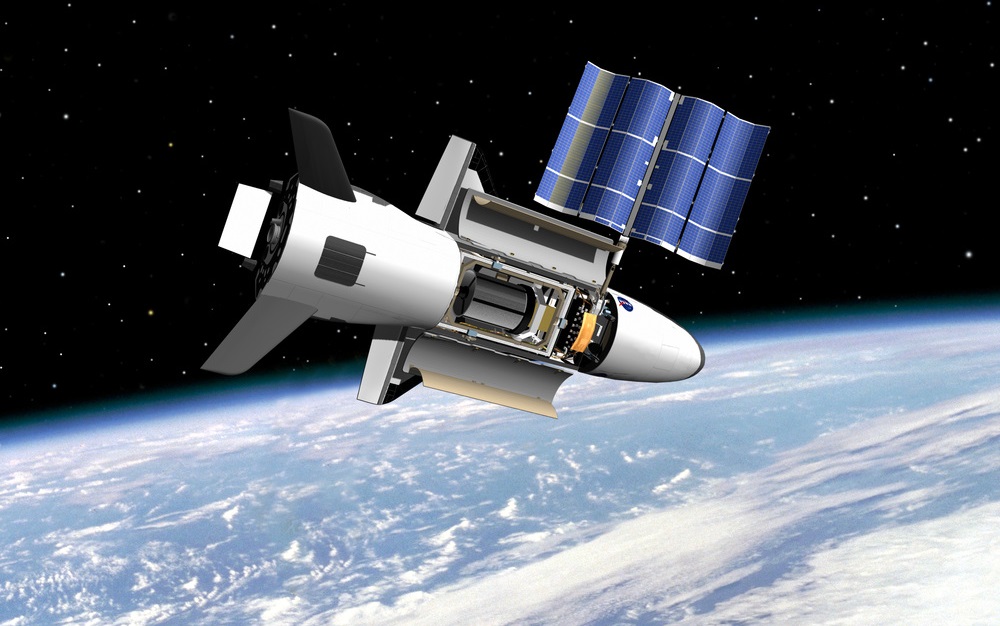
    It circled the Earth in obscurity for more than half a year, now the semi-secret X-37B OTV 5 space plane has been conclusively identified by amateur satellite observers in a circular orbit around 355 Kilometers in altitude. The orbit’s inclination at 54.5 degrees is much different from previous OTV missions and in part responsible for the craft remaining undiscovered for so long.

    X-37B, conducting its fifth orbital flight, lifted off from Launch Complex 39A at Florida’s Kennedy Space Center on September 7, 2017. In the typical secrecy surrounding the Air Force’s X-37B program, the launch was shown until separation of the protective payload fairing and confirmation of successful orbital insertion was provided a short time later but operational aspects of the mission like the craft’s operating orbit, intended mission duration and specifics on the payloads it carries were not disclosed.

    Given the hush-hush nature of its missions, X-37B is a target of intense observation by the amateur satellite community and the orbital dynamics of all four prior OTV missions were closely watched. Typically, the spacecraft was spotted in orbit within a few days after launch; however, there were several cases where observers lost track of the spacecraft due to unexpected orbital maneuvers.

    X-37B OTV 5 proved to be a tougher nut to crack as it was clear from the outset that the spacecraft would operate from a different orbit than its predecessors: “The fifth OTV mission will be launched into, and landed from, a higher inclination orbit than prior missions to further expand the X-37B’s orbital envelope,” the U.S. Air Force Rapid Capabilities Office said in a statement before the craft blasted off atop Falcon 9.
    […]
    What the spacecraft might be up to in this type of Low Earth Orbit, some 50 Kilometers lower than the International Space Station, is pretty much unknown. As with the previous X-37B flights, only very few details on the OTV 5 mission are being shared with the public and most of what resides in the vehicle’s 2.1 by 1.2-meter payload bay will remain secret.

    One payload on the OTV 5 mission that was publicly acknowledged is the Air Force Research Laboratory Advanced Structurally Embedded Thermal Spreader that will test experimental electronics and oscillating heat pipe technologies over a long-duration space flight. Three oscillating heat pipes are part of the package to evaluate the technology for future applications in space as it could offer lighter and less expensive thermal control solutions for satellite missions. The goal of the OTV-5-mounted experiment will be to evaluate the technology’s initial thermal performance and monitor it over an extended period to assess long-term degradation.

    The Air Force also said the OTV 5 mission hosts small satellite ride shares to demonstrate greater opportunities for rapid space access; however, no additional objects have been cataloged under the OTV 5 mission’s international designator 2017-052 up to this point.

  • Arctic sea ice may be declining faster than expected: study
    https://www.reuters.com/article/us-canada-arctic-research/arctic-sea-ice-may-be-declining-faster-than-expected-study-idUSKBN1CT2JD


    FILE PHOTO: A Russian border mark is pictured at the Nagurskoye military base in Alexandra Land on the remote Arctic islands of Franz Josef Land, Russia March 29, 2017. Picture taken March 29, 2017.
    REUTERS/Sergei Karpukhin

    Arctic sea ice may be thinning faster than predicted because salty snow on the surface of the ice skews the accuracy of satellite measurements, a new study from the University of Calgary said on Tuesday.

    The report from the Canadian university’s Cryosphere Climate Research Group published in the academic journal Geophysical Research Letters found satellite estimates for the thickness of seasonal sea ice have been overestimated by up to 25 percent.

    That means the Arctic Ocean could be ice-free much sooner than some scientific predictions, which forecast sea ice will first disappear completely during summer months between 2040 and 2050, according to lead author Vishnu Nandan.

    • Effect of Snow Salinity on CryoSat-2 Arctic First-Year Sea Ice Freeboard Measurements - Nandan - 2017 - Geophysical Research Letters - Wiley Online Library
      http://onlinelibrary.wiley.com/doi/10.1002/2017GL074506/full

      Abstract
      The European Space Agency’s CryoSat-2 satellite mission provides radar altimeter data that are used to derive estimates of sea ice thickness and volume. These data are crucial to understanding recent variability and changes in Arctic sea ice. Sea ice thickness retrievals at the CryoSat-2 frequency require accurate measurements of sea ice freeboard, assumed to be attainable when the main radar scattering horizon is at the snow/sea ice interface. Using an extensive snow thermophysical property dataset from late winter conditions in the Canadian Arctic, we examine the role of saline snow on first-year sea ice (FYI), with respect to its effect on the location of the main radar scattering horizon, its ability to decrease radar penetration depth, and its impact on FYI thickness estimates. Based on the dielectric properties of saline snow commonly found on FYI, we quantify the vertical shift in the main scattering horizon. This is found to be approximately 0.07 m. We propose a thickness-dependent snow salinity correction factor for FYI freeboard estimates. This significantly reduces CryoSat-2 FYI retrieval error. Relative error reductions of ~11% are found for an ice thickness of 0.95 m and ~25% for 0.7 m. Our method also helps to close the uncertainty gap between SMOS and CryoSat-2 thin ice thickness retrievals. Our results indicate that snow salinity should be considered for FYI freeboard estimates.

  • Giovanni : The Bridge Between Data and Science - Eos
    https://eos.org/project-updates/giovanni-the-bridge-between-data-and-science

    https://giovanni.gsfc.nasa.gov/giovanni

    A new infrastructure system has been designed to assist a wide range of users around the world with data access and evaluation, as well as with scientific exploration and discovery. This system, the Geospatial Interactive Online Visualization and Analysis Infrastructure (Giovanni), was developed by the NASA Goddard Earth Sciences (GES) Data and Information Services Center (DISC).

    The paramount goal of Giovanni is to provide scientists and the public with a simplified way to access, evaluate, and explore NASA satellite data sets. Here we describe the latest capabilities of Giovanni with examples, and we discuss potential future plans for this innovative system.
    […]
    Giovanni provides access to numerous satellite data sets, concentrated primarily in the areas of atmospheric composition, atmospheric dynamics, global precipitation, hydrology, and solar irradiance.

    More than 1,600 variables are currently available in Giovanni. The Web interface has keyword and faceted search capabilities for locating variables of interest (Figure 1). For example, a search for “precipitation” returns more than 100 related variables. A user performing a faceted search can filter for variables based on satellite missions (TRMM, Global Precipitation Measurement (GPM)), instruments, spatial or temporal resolution, or other categories.

  • #Satellite's #magnetic #mapping mission
    http://phys.org/news/2013-12-satellite-magnetic-mission.html

    A scientist from the University of Liverpool will play a leading role in the European Space Agency’s (ESA) satellite mission to study the Earth’s geomagnetic field.
    Dr Richard Holme, from the School of Environmental Sciences, leads the team responsible for the vector magnetic calibration for the mission, called Swarm.
    Swarm consists of three identical satellites which have successfully launched into space from Plesetsk, Russia, near the Arctic coast. Their super-sensitive instrumentation acts like a 3-D compass, enabling the precise strength and direction of the magnetic field to be determined all around the globe.
    Dr Holme said: "This satellite mission will help us to measure precisely the magnetic signals from Earth’s core, mantle, crust and oceans, as well as ionosphere and magnetosphere. What is new is to have multiple measurements in orbit at the same time but in different locations.
    “This will allow us for the first time to distinguish directly between field sources internal and external to the Earth. The resulting models will give us an insight into Earth’s interior and space weather.”
    Although invisible, the magnetic field and electric currents in and around Earth generate complex forces that have immeasurable impact on everyday life. The field can be thought of as a huge bubble, protecting us from cosmic radiation and charged particles that bombard Earth in ’solar winds’. This shield also protects the atmosphere, and so likely played an important role in the development of life on Earth.
    As well as furthering science, the measurements delivered by the three Swarm satellites will be valuable for a range of applications including improving the accuracy of navigation systems and cartography, and improving the efficiency of prospecting and drilling for natural resources.

    #