
Chine - États-Unis : en marche vers la guerre
#Chine #États-Unis #impérialisme #Taïwan #guerre #propagande
Chine - États-Unis : en marche vers la guerre
#Chine #États-Unis #impérialisme #Taïwan #guerre #propagande
Chine-États-Unis : préparatifs guerriers
►https://journal.lutte-ouvriere.org/2023/04/12/chine-etats-unis-preparatifs-guerriers_609617.html
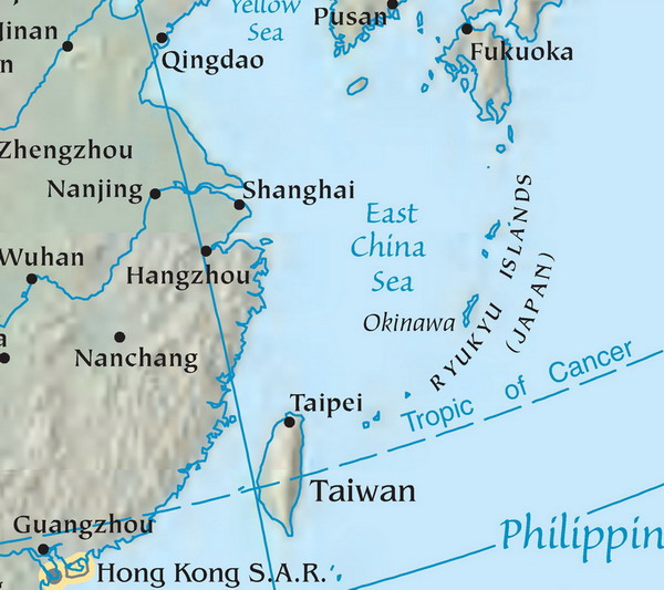
Entre le samedi 8 avril et le dimanche 10, l’armée chinoise a déployé autour de Taïwan onze bateaux de guerre et plus de 70 avions, simulant l’encerclement de l’île ainsi que son bombardement. La Chine répondait ainsi à la visite en Californie de la présidente de Taïwan, #Tsai_Ing-wen.
Cette visite, le 5 avril, s’inscrit dans la préparation de l’élection présidentielle taïwanaise de janvier 2024, une campagne que Tsai Ing-wen mène pour le compte de son parti, le DPP. Son escale américaine lui aura permis de se donner une stature internationale. Elle a salué le soutien indéfectible des États-Unis et de Kevin McCarthy, président de la Chambre des représentants américains, qui en a profité pour appeler son pays à continuer à vendre des armes à Taïwan. Les uns comme les autres espèrent ainsi enrayer la perte de vitesse du DPP sur l’île et justifier auprès de la population taïwanaise la nécessité de l’indépendance, alors qu’une partie grandissante semble en douter, si l’on en croit la défaite que le DPP a subie aux élections locales de novembre dernier au profit de son concurrent, le KMT, qui défend une ligne de statu quo, voire de rapprochement avec Pékin.
Les dirigeants du DPP et les dirigeants américains ont sans doute estimé que la réaction militaire du gouvernement chinois, s’il y en avait une, légitimerait aussi la position du DPP. Cette réaction était en effet prévisible et sans aucun doute prévue. En août 2022, la visite à Taïwan de Nancy Pelosi, qui occupait alors la même fonction que McCarthy, avait provoqué des manœuvres de plus grande ampleur encore. Alors que le gouvernement de Pékin affirme depuis toujours que Taïwan fait partie de la #Chine et que son indépendance formelle est un motif de guerre, les #États-Unis et le DPP, avec ces contacts d’officiels au plus haut niveau, font monter la pression. Ils savent pertinemment que le #gouvernement_chinois ne peut pas ne pas répondre.
L’armée chinoise s’est ainsi déployée pendant trois jours, simulant l’encerclement et le #bombardement de l’île, faisant franchir à plusieurs dizaines de ses avions la ligne médiane du détroit de Taïwan, et mettant en œuvre son dernier porte-avions, le Shandong, qui navigue dans la zone à environ 370 km à l’est de l’île. L’#armée_chinoise a également annoncé que les manœuvres autour de Taïwan seraient prolongées par d’autres jusqu’au 20 avril au large du #Fujian, dans le détroit de Taïwan. Les États-Unis, dont une partie de la flotte est en permanence sur zone, le #porte-avions américain Nimitz en particulier se trouvant à proximité, en ont profité pour observer les capacités militaires de la #marine_chinoise et pour montrer à leur tour leur présence et leur puissance. Ils ont ainsi déployé le 9 avril un destroyer en #mer_de_Chine_méridionale, un peu au sud de Taïwan, dans une opération dite de liberté de navigation, consistant à croiser à proximité des îles que les Chinois se sont appropriées. Et mardi 11 avril, ils ont entamé leurs exercices militaires annuels conjoints avec les Philippines en mobilisant au total 18 000 soldats, deux fois plus qu’en 2022.
Les dirigeants taïwanais et américains préparent les esprits à la guerre. Les dirigeants chinois ne sont pas en reste. #Taïwan et ses 23 millions d’habitants deviennent ainsi l’enjeu d’un affrontement qui les dépasse.
Chine-États-Unis : une concurrence féroce mais inégale
▻https://mensuel.lutte-ouvriere.org/2022/01/23/chine-etats-unis-une-concurrence-feroce-mais-inegale_196804.
(#archiveLO, 9 janvier 2022)
– Une nouvelle superpuissance ?
– Des relations inégalitaires
– Un nouvel #impérialisme ?
– Le « rêve chinois » de Xi Jinping
– Guerre économique : le raidissement des États-Unis
– Les provocations occidentales
– La #guerre, une menace toujours plus proche
Océan pacifique : préparatifs guerriers
▻https://journal.lutte-ouvriere.org/2023/03/15/ocean-pacifique-preparatifs-guerriers_552402.html
(#archiveLO, 15 mars 2023)
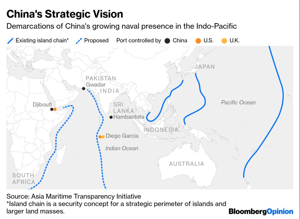
Depuis la base navale californienne de San Diego, le président américain Biden, le premier ministre britannique Sunak et son homologue australien Albanese ont lancé le 13 mars la nouvelle phase de leur alliance militaire.
Les trois pays développeront ensemble et construiront dans leurs arsenaux respectifs un nouveau type de #sous-marin d’attaque à propulsion nucléaire (SNA). La série est baptisée SNN Aukus, comme l’alliance #Australie- UK- USA. En attendant les premiers lancements, prévus pour 2040, les États-Unis fourniront, sous deux ans, trois voire cinq SNA à la marine australienne. Le #budget officiel de ce programme dépasse les 200 milliards de dollars.
En plus de la montée en puissance navale, #Aukus marque l’intégration de plus en plus poussée dans la marine américaine des marines britannique et australienne, de leurs arsenaux et de leurs équipages. Le projet comprend aussi des groupes de recherche dans des domaines intéressant l’armement, depuis les missiles hypersoniques jusqu’aux ordinateurs quantiques nécessaires pour la guerre de l’espace. La marine japonaise, déjà en partie équipée par les États Unis et coordonnée avec eux, ne devrait pas tarder à rejoindre cette alliance évidemment dirigée contre la Chine.
Pour justifier ce programme guerrier les porte-parole officiels et officieux de l’#impérialisme américain montent en épingle la menace chinoise. Cela va du ridicule, comme l’interdiction du réseau social pour ados Tik-Tok, au terrifiant, en affirmant que la flotte chinoise serait désormais la plus puissante au monde.
La flotte chinoise, si l’on compte tous ses bâtiments jusqu’à la plus modeste vedette des douanes, est certes la plus nombreuse. Mais la #flotte_américaine, sans même intégrer Aukus, l’Otan et les autres alliés, reste de très loin la plus puissante. Les États-Unis détiennent 14 sous-marins nucléaires lanceurs d’engins à tête nucléaire, alors que la #Chine en a sept. Et, surtout, ils arment 50 SNA soit la moitié de ceux en service actuellement dans le monde, alors que la Chine en a neuf. Enfin, un seul des onze #porte-avions américains, les plus gros, les plus rapides, les plus armés et les seuls dotés de catapultes, est plus écrasant et plus coûteux que les trois porte-avions chinois réunis.
Aujourd’hui le programme naval Aukus est une garantie de bénéfices considérables pour des marchands de canons américains déjà multimilliardaires et, exceptionnellement, une fleur pour leur confrère britannique #BAE_Systems. Par la constitution d’une force navale intégrée, c’est aussi l’indication des camps d’un futur conflit général qui se dessinent et se préparent techniquement. Loin de défendre la paix, l’impérialisme promet la #guerre.
Chine-États-Unis : préparatifs guerriers
►https://journal.lutte-ouvriere.org/2023/04/12/chine-etats-unis-preparatifs-guerriers_609617.html
(#archiveLO, 12 avril 2023)
Entre le samedi 8 avril et le dimanche 10, l’armée chinoise a déployé autour de Taïwan onze bateaux de guerre et plus de 70 avions, simulant l’encerclement de l’île ainsi que son bombardement. La Chine répondait ainsi à la visite en Californie de la présidente de Taïwan, Tsai Ing-wen.
Cette visite, le 5 avril, s’inscrit dans la préparation de l’élection présidentielle taïwanaise de janvier 2024, une campagne que Tsai Ing-wen mène pour le compte de son parti, le DPP. Son escale américaine lui aura permis de se donner une stature internationale. Elle a salué le soutien indéfectible des États-Unis et de Kevin McCarthy, président de la Chambre des représentants américains, qui en a profité pour appeler son pays à continuer à vendre des armes à Taïwan. Les uns comme les autres espèrent ainsi enrayer la perte de vitesse du DPP sur l’île et justifier auprès de la population taïwanaise la nécessité de l’indépendance, alors qu’une partie grandissante semble en douter, si l’on en croit la défaite que le DPP a subie aux élections locales de novembre dernier au profit de son concurrent, le KMT, qui défend une ligne de statu quo, voire de rapprochement avec Pékin.
Les dirigeants du DPP et les dirigeants américains ont sans doute estimé que la réaction militaire du gouvernement chinois, s’il y en avait une, légitimerait aussi la position du DPP. Cette réaction était en effet prévisible et sans aucun doute prévue. En août 2022, la visite à Taïwan de Nancy Pelosi, qui occupait alors la même fonction que McCarthy, avait provoqué des manœuvres de plus grande ampleur encore. Alors que le gouvernement de Pékin affirme depuis toujours que Taïwan fait partie de la Chine et que son indépendance formelle est un motif de guerre, les États-Unis et le DPP, avec ces contacts d’officiels au plus haut niveau, font monter la pression. Ils savent pertinemment que le gouvernement chinois ne peut pas ne pas répondre.
L’armée chinoise s’est ainsi déployée pendant trois jours, simulant l’encerclement et le bombardement de l’île, faisant franchir à plusieurs dizaines de ses avions la ligne médiane du détroit de Taïwan, et mettant en œuvre son dernier porte-avions, le Shandong, qui navigue dans la zone à environ 370 km à l’est de l’île. L’armée chinoise a également annoncé que les manœuvres autour de Taïwan seraient prolongées par d’autres jusqu’au 20 avril au large du Fujian, dans le détroit de Taïwan. Les États-Unis, dont une partie de la flotte est en permanence sur zone, le porte-avions américain Nimitz en particulier se trouvant à proximité, en ont profité pour observer les capacités militaires de la marine chinoise et pour montrer à leur tour leur présence et leur puissance. Ils ont ainsi déployé le 9 avril un destroyer en mer de Chine méridionale, un peu au sud de Taïwan, dans une opération dite de liberté de navigation, consistant à croiser à proximité des îles que les Chinois se sont appropriées. Et mardi 11 avril, ils ont entamé leurs exercices militaires annuels conjoints avec les Philippines en mobilisant au total 18 000 soldats, deux fois plus qu’en 2022.
Les dirigeants taïwanais et américains préparent les esprits à la guerre. Les dirigeants chinois ne sont pas en reste. Taïwan et ses 23 millions d’habitants deviennent ainsi l’enjeu d’un affrontement qui les dépasse.

#Taïwan, : les dérives nationalistes de la #Chine de #Xi_Jinping
Xi Jinping se prépare à un troisième mandat de cinq ans et à une démonstration de force au cours du 20e #congrès_du_Parti_communiste_chinois. Alors que son nationalisme exacerbé se traduit à la fois à l’intérieur des frontières, avec la répression des Ouïghours, et dans son environnement proche, en #Mer_de_Chine_du_sud, avec une pression accrue sur Taïwan, nous analysons les enjeux de ce congrès avec nos invité·es, Laurence Defranoux, journaliste et autrice des Ouïghours, histoire d’un peuple sacrifié, Noé Hirsch, spécialiste de la Chine, Maya Kandel, historienne spécialiste des États-Unis, et Inès Cavalli, chercheuse en études chinoises.
▻https://www.youtube.com/watch?v=U4wiIwCaSY8
CNES Géoimage Nouvelles ressources
Dans une situation difficile, tendue et régressive, les cours en présentiel sont impossibles, les bibliothèques, universitaires en particulier, et les librairies sont fermées et les risques de décrochages se multiplient. Dans ce contexte, le site Géoimage du CNES (Centre Nat. d’Etudes Spatiales) met à disposition en ligne plus de 300 dossiers réalisés par 165 auteurs sur 86 pays et territoires. Pour votre information, voici les derniers dossiers réalisés ces deux derniers mois. Ils constituent peut être une ressource utile pour vos étudiants. En restant a votre disposition.
1. Nouveaux dossiers en ligne
#Frontières : entre #guerres, #tensions et #coopérations
#Pakistan-#Inde-#Chine. Le massif du #K2 et le #Glacier_Siachen : #conflits_frontaliers et affrontements militaires sur le « toit du monde » (L. Carroué )
▻https://geoimage.cnes.fr/fr/pakistan-inde-chine-le-massif-du-k2-et-le-glacier-siachen-conflits-fro
Pakistan-Chine. La #Karakoram_Highway : un axe transfrontalier géostratégique à travers l’#Himalaya (L. Carroué)
▻https://geoimage.cnes.fr/fr/geoimage/pakistan-chine-la-karakoram-highway-un-axe-transfrontalier-geostrategi
#Afghanistan/ #Pakistan/ #Tadjikistan - Le corridor de #Wakhan : une zone tampon transfrontalière en plein Himalaya (L. Carroué)
▻https://geoimage.cnes.fr/fr/afghanistan-pakistan-tadjikistan-le-corridor-de-wakhan-une-zone-tampon
Affrontement aux sommets sur la frontière sino-indienne, autour du #Lac_Pangong_Tso dans l’Himalaya (F. Vergez)
►https://geoimage.cnes.fr/fr/geoimage/affrontement-aux-sommets-sur-la-frontiere-sino-indienne-sur-le-lac-pan
#Brésil - #Argentine – #Paraguay. La triple frontière autour d’#Iguazu : un des territoires transfrontaliers les plus actifs au monde (C. Loïzzo)
▻https://geoimage.cnes.fr/fr/geoimage/bresil-argentine-paraguay-la-triple-frontiere-autour-diguazu-un-des-te
#Grèce – #Turquie. Les îles grecques de #Samos et #Lesbos en #mer_Egée : tensions géopolitiques frontalières et flux migratoires (F. Vergez)
▻https://geoimage.cnes.fr/fr/geoimage/grece-turquie-les-iles-grecques-de-samos-et-lesbos-en-mer-egee-tension
#Jordanie/ #Syrie : guerre civile, frontière militarisée et #camps_de_réfugiés de #Zaatari (L. Carroué)
▻https://geoimage.cnes.fr/fr/geoimage/jordanie-syrie-guerre-civile-frontiere-militarisee-et-camps-de-refugie
Frontières : France métropolitaine et outre-mer
#Calais : un port de la façade maritime européenne aux fonctions transfrontalières transmanches (L. Carbonnier et A. Gack)
▻https://geoimage.cnes.fr/fr/geoimage/hauts-de-france-calais-un-port-de-la-facade-maritime-europeenne-aux-fo
L’Est-#Maralpin : un territoire transfrontalier franco-italo-monégaste au cœur de l’arc méditerranéen (F. Boizet et L. Clerc)
▻https://geoimage.cnes.fr/fr/lest-maralpin-un-territoire-transfrontalier-franco-italo-monegaste-au-
La principauté de #Monaco : le défi du territoire, entre limite frontalière, densification et extensions urbaines maritimes (P. Briand)
▻https://geoimage.cnes.fr/fr/geoimage/la-principaute-de-monaco-le-defi-du-territoire-entre-limite-frontalier
#Guyane_française/ Brésil. La frontière : d’un territoire longtemps contesté à une difficile coopération régionale transfrontalière (P. Blancodini )
▻https://geoimage.cnes.fr/fr/geoimage/guyane-francaise-bresil-la-frontiere-un-territoire-longtemps-conteste-
(Frontières. Pages concours - Capes, Agrégations)
►https://geoimage.cnes.fr/fr/geoimage/les-frontieres
Enjeux géostratégiques et géopolitiques
Pakistan. #Gwadar : un port chinois des Nouvelles Routes de la Soie dans un #Baloutchistan désertique et instable (C. Loïzzo)
▻https://geoimage.cnes.fr/fr/geoimage/pakistan-gwadar-un-port-chinois-des-nouvelles-routes-de-la-soie-dans-u
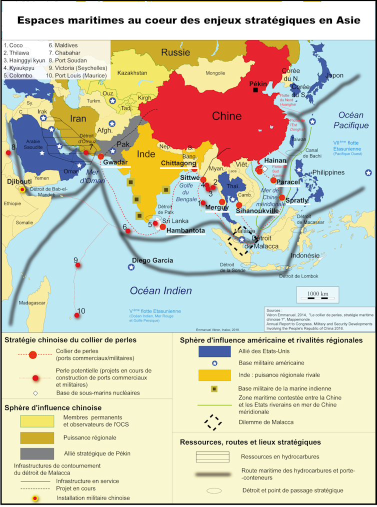
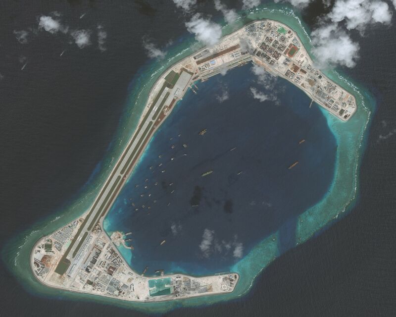
#Chine. L’archipel des #Paracels : construire des #îles pour projeter sa puissance et contrôler la #Mer_de_Chine méridionale (L. Carroué)
Chine - L’archipel des Paracels : construire des îles pour projeter sa puissance et contrôler la Mer de Chine méridionale
#Kings_Bay : la grande base sous-marine nucléaire stratégique de l’#Atlantique (L. Carroué)
▻https://geoimage.cnes.fr/fr/geoimage/etats-unis-kings-bay-la-grande-base-sous-marine-nucleaire-strategique-
#Kitsap - #Bangor : la plus grande #base_sous-marine nucléaire stratégique au monde (L. Carroué)
▻https://geoimage.cnes.fr/fr/geoimage/etats-unis-kitsap-bangor-la-plus-grande-base-sous-marine-nucleaire-str
#Djibouti / #Yémen. Le détroit de #Bab_el-Mandeb : un verrou maritime géostratégique entre la #mer_Rouge et l’#océan_Indien (E. Dallier et P. Denmat)
▻https://geoimage.cnes.fr/fr/geoimage/djiboutiyemen-le-detroit-de-bab-el-mandeb-un-verrou-maritime-geostrate
#Abu_Dhabi : une ville capitale, entre mer et désert (F. Tétart)
▻https://geoimage.cnes.fr/fr/geoimage/emirats-arabes-unis-abu-dhabi-une-ville-capitale-entre-mer-et-desert
France et #DROM : dynamiques et mutations
Languedoc. #Cap_d’Agde : une station touristique au sein d’un littoral très aménagé en région viticole (Y. Clavé)
▻https://geoimage.cnes.fr/fr/geoimage/languedoc-cap-dagde-une-station-touristique-au-sein-dun-littoral-tres-
Le sud-est de la #Grande-Terre : les plages touristiques et les #Grands_Fonds, entre survalorisation, inégalités et développement durable (J. Fieschi et E. Mephara)
▻https://geoimage.cnes.fr/fr/geoimage/guadeloupe-le-sud-est-de-la-grande-terre-les-plages-touristiques-et-le
#Normandie. #Lyons-la-Forêt et son environnement : entre #Rouen et Paris, un espace rural sous emprise forestière (T. Puigventos)
▻https://geoimage.cnes.fr/fr/geoimage/normandie-lyons-la-foret-et-son-environnement-entre-rouen-et-paris-un-
#PACA. L’agglomération de #Fréjus - #Saint-Raphaël : un #littoral méditerranéen touristique urbanisé (S. Revert)
▻https://geoimage.cnes.fr/fr/geoimage/paca-lagglomeration-de-frejus-saint-raphael-un-littoral-mediterraneen-
#Tourisme et #patrimonialisation dans le monde
#Portugal – #Lisbonne : la capitale portugaise aux défis d’une #touristification accélérée et d’une patrimonialisation accrue (J. Picollier)
Portugal - Lisbonne : la capitale portugaise aux défis d’une touristification accélérée et d’une patrimonialisation accrue
#Floride : le Sud-Ouest, un nouveau corridor touristique et urbain (J.F. Arnal)
▻https://geoimage.cnes.fr/fr/geoimage/etats-unis-floride-le-sud-ouest-un-nouveau-corridor-touristique-et-urb
#Alaska. Le #Mont_Denali : glaciers, #parc_national, #wilderness et changement climatique (A. Poiret)
▻https://geoimage.cnes.fr/fr/geoimage/alaska-le-mont-denali-glaciers-parc-national-wilderness-et-changement-
#Ile_Maurice. Le miracle de l’émergence d’une petite île de l’#océan_Indien (M. Lachenal)
▻https://geoimage.cnes.fr/fr/geoimage/ile-maurice-le-miracle-de-lemergence-dune-petite-ile-de-locean-indien
Le #Grand-Prismatic du Parc National du #Yellowstone : entre wilderness, protection, patrimonialisation et tourisme de masse (S. Sangarne et N. Vermersch)
▻https://geoimage.cnes.fr/fr/geoimage/etats-unis-le-grand-prismatic-du-parc-national-du-yellowstone-entre-wi
#Maroc. Contraintes, défis et potentialités d’un espace désertique marocain en bordure du Sahara : Ouarzazate (M. Lachenal)
▻https://geoimage.cnes.fr/fr/geoimage/maroc-contraintes-defis-et-potentialites-dun-espace-desertique-marocai
2. Nouvelle rubrique : « Images A la Une »
La rubrique Image A La Une a pour objectif de mettre en ligne une image satellite accompagnée d’un commentaire en lien avec un point d’actualité et qui peut donc être facilement mobilisée en cours (cf. incendies de forêt en Australie en janv./ 2020, impact du Coronavirus en avril 2020).
Fabien Vergez : Affrontements aux sommets sur la frontière sino-indienne, sur le lac Pangong Tso dans l’Himalaya
►https://geoimage.cnes.fr/fr/geoimage/affrontement-aux-sommets-sur-la-frontiere-sino-indienne-sur-le-lac-pan
Virginie Estève : Les "#Incendies_zombies" en #Arctique : un phénomène surmédiatisé qui alerte sur le réchauffement climatique.
▻https://geoimage.cnes.fr/fr/geoimage/incendies-zombies-en-arctique-un-phenomene-surmediatise-qui-alerte-sur
3. Ouverture d’une nouvelle rubrique : « La satellithèque »
Le site Géoimage du CNES se dote d’une nouvelle rubrique afin d’enrichir son offre. A côté des images déjà proposées dans les rubriques "dossiers thématiques" ou "Images A la Une", le site Géoimage du CNES met en ligne comme autres ressources des images brutes non accompagnées d’un commentaire ou d’une analyse.
L’objectif de cette #Satellithèque est d’offrir au plus grand nombre - enseignants, universitaires, chercheurs, étudiants, grand public... - de nombreuses images de la France et du monde. Ainsi, progressivement, dans les mois qui viennent des centaines d’images nouvelles seront disponibles et téléchargeable directement et gratuitement en ligne afin d’accompagner leurs travaux, recherches ou voyages.
▻https://geoimage.cnes.fr/fr/geoimage/satellitheque
4. Ouverture de comptes Twitter et Instagram
Suivez et partagez l’actualité du site GeoImage à travers Twitter / Instagram, que ce soit de nouvelles mises en ligne ou des évènements autour de ce projet. La publication de nouveaux dossiers et leurs référencements, tout comme la publication de notules dans images à la une est accompagnée de brèves sur ces réseaux sociaux
Ci-dessous les identifiants pour s’abonner aux comptes Twitter et Instagram
Compte twitter : @Geoimage_ed
Compte Instagram : geoimage_ed

South China Sea: US unveils first sanctions linked to militarisation | South China Sea | The Guardian
▻http://www.theguardian.com/world/2020/aug/27/south-china-sea-us-unveils-first-sanctions-linked-to-militarisation
The United States has blacklisted 24 Chinese companies and targeted individuals it said were part of construction and military efforts in the South China Sea, its first such sanctions move over the disputed strategic waterway.
The US Commerce Department said the companies played a “role in helping the Chinese military construct and militarise the internationally condemned artificial islands in the South China Sea”.

Les installations fixes en #Mer_de_Chine_méridionale
(base de données)
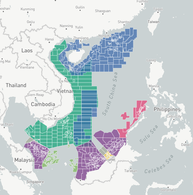
Island Tracker Archive | Asia Maritime Transparency Initiative
▻https://amti.csis.org/island-tracker
Five claimants occupy nearly 70 disputed reefs and islets spread across the #South_China_Sea. They have built more than 90 outposts on these contested features, many of which have seen expansion in recent years. AMTI has gathered satellite imagery of each outpost, along with other relevant information, to document their current status and any changes they have undergone in recent years. Explore the database below.
Chine : 27
Malaisie : 5
Philippines : 9
Taiwan : 1
Vietnam : 21 (+ 6 plateformes)
exemple : Lansdowne Reef | Asia Maritime Transparency Initiative
▻https://amti.csis.org/lansdowne-reef
Lansdowne Reef is a rock located in the Spratly Islands. Vietnam first took possession of the feature in 1988.
High-seas energy fight off Malaysia draws US, Chinese warships, SE Asia News & Top Stories - The Straits Times
▻https://www.straitstimes.com/asia/se-asia/high-seas-energy-fight-off-malaysia-draws-us-chinese-warships
Malaysia’s push to explore energy blocks off its coast has turned into a five-nation face off involving US and Chinese warships, raising the risk of a direct confrontation as broader tensions grow between the world’s biggest economies.
The episode began in December, when Malaysia’s state-run energy giant Petroliam Nasional Bhd contracted a vessel to explore two areas in the South China Sea in its extended continental shelf.
Those waters are also claimed by Vietnam and China, which immediately sent ships to shadow the boat.
The situation took a turn for the worse on April 16 with the arrival of a Chinese surveyor known as the Haiyang Dizhi 8, which last year was engaged in a standoff with Vietnam over offshore energy blocks.
The US this week sent at least two warships within some 50 nautical miles of the Malaysian ship, according to defence analysts privy to the information who asked not to be identified.
US Secretary of State Michael Pompeo on Thursday (April 24) accused China of “exploiting” the world’s focus on the Covid-19 pandemic with provocations in the South China Sea.
In a statement issued on the same day he held a video call with 10 South-east Asian foreign ministers, he said China “dispatched a flotilla that included an energy survey vessel for the sole purpose of intimidating other claimants from engaging in offshore hydrocarbon development”.
“The US strongly opposes China’s bullying and we hope other nations will hold them to account too,” Mr Pompeo said.
TERRITORIAL DISPUTES
The US doesn’t take a position on territorial disputes in the region even while staking a national interest in freedom of navigation, which involves challenging any claims that aren’t consistent with international laws.
As China gets more assertive in enforcing its claims, it’s increased the risk of a potential confrontation with the US that could quickly escalate.
The US Indo-Pacific Command confirmed on Wednesday that three ships - the USS America, an amphibious assault ship; the USS Bunker Hill, a guided missile cruiser; and the USS Barry, an Arleigh Burke-class guided missile destroyer - were operating in the South China Sea, without giving a precise location.
They were joined by an Australian Anzac-class frigate on April 18, according to the US 7th Fleet.
“The risk of a new incident is rising, as tension elsewhere in the relationship could inflame the situation on the ground, or rather, in the water,” New York-based risk consultancy Eurasia Group said in an analysis on Wednesday.
un peu de localisation précise (à fin février), pas forcément facile à trouver au milieu des gesticulations (le West Capella est hors de portée des stations AIS terrestres, sa localisation - par satellite - n’est donc pas accessible via l’accès gratuit à MarineTraffic).
Malaysia Picks a Three-Way Fight in the South China Sea | Asia Maritime Transparency Initiative
▻https://amti.csis.org/malaysia-picks-a-three-way-fight-in-the-south-china-sea
A months-long standoff over oil and gas operations in the South China Sea is playing out between Malaysian, Chinese, and a small number of Vietnamese vessels, though all three governments are keeping the episode out of the public eye.
At issue are two oil and gas fields that Malaysia’s state-owned Petronas is exploring on the extended continental shelf claimed by both Kuala Lumpur and Hanoi. These fields sit within Malaysian oil and gas blocks ND1 and ND2. China has responded with a campaign of intimidation reminiscent of its operations against Malaysian and Vietnamese oil and gas work last year. Those operations have spilled over to include harassment of other Malaysian oil and gas work closer to shore.
AMTI has tracked the standoff using the vessels’ automatic identification system (AIS) broadcasts along with commercial satellite imagery. This data reveals a dangerous, ongoing game of chicken involving law enforcement, militia, and civilian vessels. It is necessarily an incomplete picture—it only captures those ships broadcasting AIS or which happened to be in the area when a satellite image was captured. It is entirely likely that additional naval, air, law enforcement, and militia assets from all sides have been involved over the last two months. But the available data captures those vessels that have been most heavily involved, particularly China Coast Guard (CCG) ships Haijing 5203 and 5305. It also reiterates the #new_normal in the #South_China_Sea: that new energy development by Southeast Asian states anywhere within the nine-dash line will be met by persistent, high-risk intimidation from Chinese law enforcement and paramilitary vessels.
The West Capella, a drillship operated by London-managed Seadrill and contracted to Petronas, is at the heart of the standoff. In October 2019, the West Capella began operating in oil and gas block ND4 off the coast of Malaysia’s Sabah State. From December 6 to 9, two CCG ships—the Haijing 5202 and 5403 —patrolled around the vessel, presumably taking time off from escorting a fishing fleet which would later provoke a very public standoff with Indonesia. At nearly 5,000 tons, the Zhaolai-class 5403 is one of the most intimidating ships in the CCG arsenal. At 2,700 tons, the Zhaojun-class 5202 is considerably smaller but much better armed, sporting a 76-mm cannon.
suit le suivi détaillé de plusieurs opérations. de décembre 2019 à février 2020. La dernière :
A Chinese fishing vessel named Lurongyuyun 50018 left Hainan on February 15, arriving in ND1 the next day. AIS data from February 17 showed the ship, apparently a member of China’s maritime militia, approaching close to the West Capella and several offshore supply vessels servicing it. The fishing boat also appears to have interacted with the 5305, which then headed to Fiery Cross Reef for resupply, and the 5302, which was passing through on its way from Luconia Shoals to Hainan.
As of publication, the standoff is ongoing. The West Capella and its offshore supply vessels continue to operate in block ND1. Vietnamese militia vessels remain on-station monitoring and likely demanding it halt its work. Chinese militia and law enforcement ships continue to approach dangerously close to the rig and supply vessels, creating risks of collision as they have during other oil and gas operations over the last year. So far, the Malaysian government appears determined to continue the exploration. But China’s response sends a message that actual production of oil and gas in blocks ND1 and ND2 would be prohibitively risky for any commercial actor, including Petronas. The motivations of China and Vietnam seem clear. The biggest question is why the Malaysian government chose to ignore the spirit of the 2009 join submission with Vietnam and, in so doing, undermine whatever solidarity Southeast Asian parties might hope to build in their oil and gas disputes with Beijing.

South China Sea: Malaysia, Indonesia, And Vietnam Beat China At Its Own Game
▻https://www.forbes.com/sites/panosmourdoukoutas/2020/01/10/south-china-sea-malaysia-indonesia-and-vietnam-beat-china-at-its-own-game
This isn’t the first time Malaysia appealed to the UN to protect its territories. Back in 2009, it joined Vietnam to submit for an extension of CLCS beyond 200 nautical miles (nm) in 2009, a year after, had submitted its petition for an extension of CLCS beyond 200 nm in the northwest area of Sumatra Island on June 16, 2008.
“This move is a departure from earlier protests notes issued by Malaysia on China’s activities including the presence of its coast guards near Malaysian territorial waters,” adds Goswami. “Protests notes were never made public though. Therefore, to submit to the UN on its continental shelf claim is strategic escalation, and beating China on its own game; the use of lawfare to settle disputes.”
For years, China has made a reputation for using UN lawfare to advance its South China Sea agenda. Now Malaysia and its neighbors have “turned the tables” on Beijing. They, too, have been using the UN to advance their own South China Sea agenda.

À feu et à sable
▻https://www.youtube.com/watch?v=XwJGWea4fyM
Le chemin de nos vies modernes crisse à chaque pas au bruit des grains de sable qui l’ont pavé. Dans nos immeubles, nos routes, nos portables, nos médicaments ou les bouteilles de nos ivresses... Il est devenu le matériau à tout faire d’une société d’abondance. Sans que jamais n’apparaisse les circuits tortueux de cet ingrédient miracle. Source : #Datagueule 92

Ici une nouvelle (pas très bien sourcée) sur les accaparements de sol dans les Philippines, pour remblayer notamment des polders dans des zones où le prix des terres s’envole.
#extractivisme #construction
▻https://seenthis.net/messages/819936
Il est question de #barrages, de extractivistes, de #polders, de #mer_de_Chine, d’#artificialisation des #plages et d’#effondrement très matériel de plages et de rives de fleuves comme le #Mekong.
#philosophie_de_la_nature derrière et #gilets_jaunes.
Le docu sur le sable d’Arte a été mis ici.
▻https://www.youtube.com/watch?v=MFEM8PznN7s


Journal articles ‘tacitly support China territory grab’
The role of academic journals in adjudicating on fiercely disputed territorial claims in the South China Sea has come under scrutiny as Chinese scholars use maps endorsing China’s position.
Papers by Chinese researchers, often co-authored with Western collaborators, have been illustrated with maps that include the “nine-dash line” – a U-shaped borderline stretching south from China and Taiwan to Borneo. It envelopes islands and reefs claimed by Brunei, Malaysia, the Philippines, Taiwan and Vietnam, including Scarborough Shoal and the Spratly Islands.
An international tribunal convened in The Hague in 2016 under the United Nations Convention on the Law of the Sea ruled against the line. China disputes the ruling.
Clive Hamilton, professor of public ethics at Charles Sturt University in Canberra, claimed that the issue echoed moves in 2017 by Springer Nature and Cambridge University Press to appease China by removing politically sensitive articles from their Chinese websites.
“Here’s another example of Beijing asserting its claims through international scientific journals,” said Professor Hamilton, a high-profile critic of Chinese foreign policy.
“A very big, economically powerful authoritarian power [is] engaged in a political struggle over territory, and wants the international scientific community to in effect endorse its claim by publishing maps that have no validity under international law.”
He said Chinese researchers “would undoubtedly suffer if they were authors of an article in an international journal that included the South China Sea but did not show the nine-dash line”.
However, one influential journal said that it was “not unusual” for scientific publishers to remain neutral on jurisdictional claims, while a China expert warned of the difficulty of requiring peer reviewers to be aware of and enforce geopolitical issues.
Times Higher Education has found nine-dash line representations in nine journal articles by Chinese researchers. Most have been published since early last year, and none is about maritime issues. The papers’ subject matter includes bamboo, butterflies and Tibetan vegetation. Five boast co-authors from Australia, Germany, Scotland, Singapore and the US.
An Australian geneticist based in Japan said maps depicting Chinese ownership of South China Sea islands appeared in about half the Chinese-authored papers he came across. Their frequency was increasing, the scientist continued, and they now appeared in high-ranking international journals as well as in smaller publications favoured by Chinese authors.
The researcher, who asked not to be named, said he had objected to such a map’s inclusion in a forthcoming paper he wrote with Chinese collaborators. “I was told that they cannot do anything because it is a requirement of the Chinese Communist Party. They are provided with official maps that they have to use.
“Most [foreign co-authors] choose to ignore it, perhaps because they think it is not worth the trouble to say anything. Journals do not give guidelines on how to deal with the issue when reviewing papers.”
THE sought comment from the journals Cells, Diversity and Distributions, Molecular Ecology, New Phytologist and Plos One. The last was the only one to respond, saying that a policy introduced last year required territorial descriptions in submitted manuscripts to “follow international treaties and conventions”.
“Otherwise, Plos remains neutral on any jurisdictional claims expressed,” it added. “This policy is not unusual in scientific publishing.”
Professor Hamilton said journals that failed to enforce such policies “implicitly endorsed a claim that violated the rights of poor Filipino fishermen. My guess is editors have probably not had it drawn to their attention,” he added.
University of Melbourne entomologist Nancy Endersby co-authored a 2019 Cells paper that contains representations of the nine-dash line. “If I had been aware of this inclusion and its significance, I would not have allowed my name to be on the paper,” she said. “I focused on the molecular aspect of the paper and trusted [the] map was accurate.”
Co-author Ary Hoffman said: “Now that we’re aware of it, we’ll certainly look for it in any future collaborative efforts. As biologists, it is not something that was on our radar.”
James Laurenceson, head of the Australia-China Relations Institute at the University of Technology Sydney, supported Professor Hamilton in raising the issue. He said Chinese academics were likely to assume that Beijing would “look approvingly” on their reproduction of the nine-dash line.
“But I wouldn’t necessarily take it as evidence that they’ve been directed to do so,” he said. “I’m not sure the Chinese bureaucracy is that organised.”
Professor Laurenceson said peer review had failed to pick up the offending maps. “Finding peer reviewers of journals is tough enough already,” he said. “If we insist that they’re also aware of geopolitical issues, many academics are just not going to have the time to be abreast of it.”
▻https://www.timeshighereducation.com/news/journal-articles-tacitly-support-china-territory-grab
#manipulation #cartographie #visualisation #Chine #Philippines #différend_territorial #revues_scientifiques #recherche #nine-dash_line #Mer_de_Chine_méridionale #responsabilité
ping @simplicissimus @reka
La Chine maritime et navale (7/7) : les touristes chinois sur tous les océans - Asialyst
▻https://asialyst.com/fr/2019/10/12/chine-maritime-navale-7-7-touristes-chinois-sur-tous-oceans
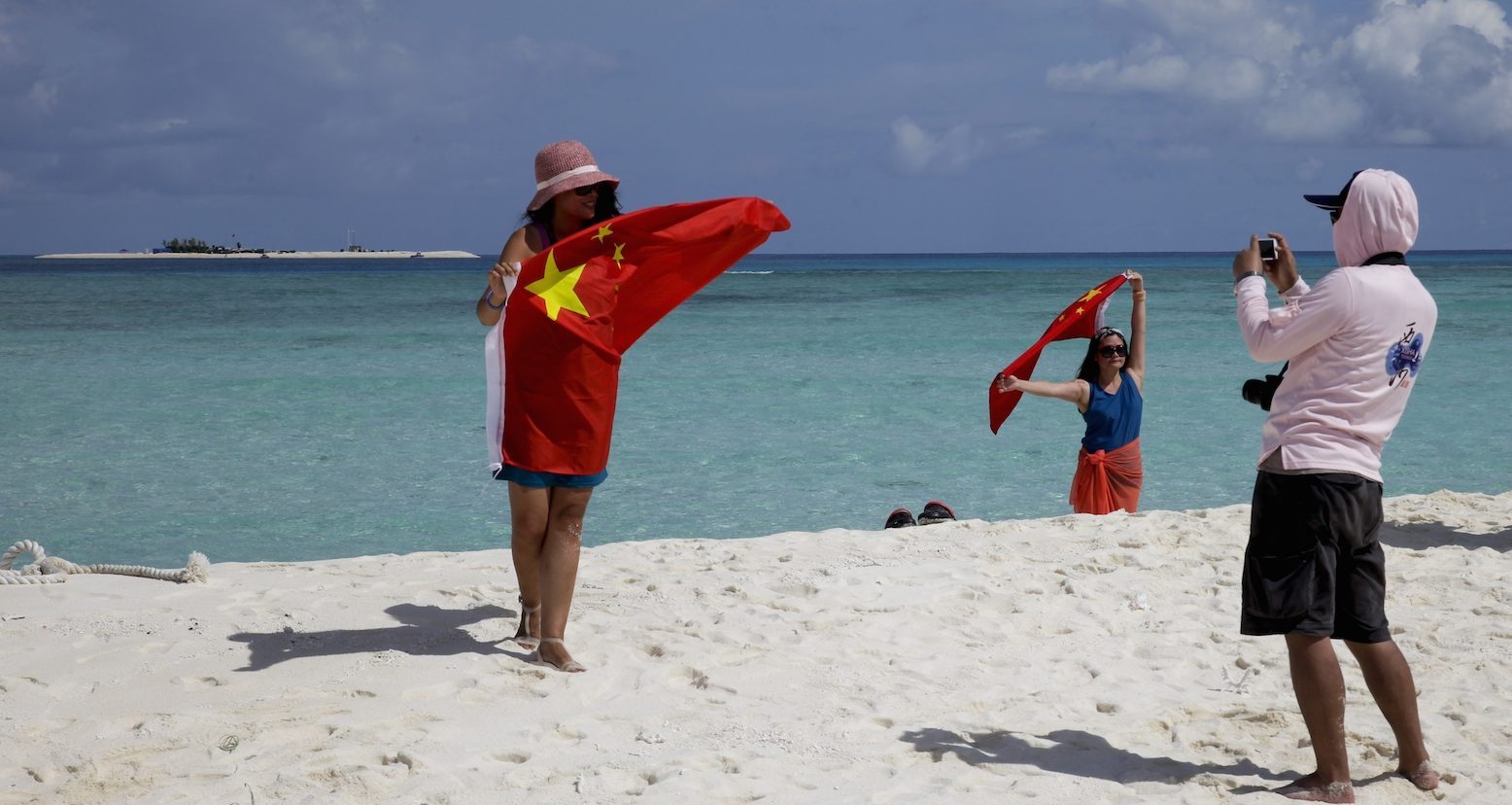 https://asialyst.com/fr/wp-content/uploads/2019/10/touristes-patriotiques-chinois-e1570836521515.jpg
 Le plus étonnant dans le tourisme maritime des Chinois, ce n’est pas seulement qu’ils inondent les plages de Qingdao à Phuket. Mais c’est à quel point la hausse du niveau vie et l’émergence d’une classe de super riches en Chine populaire ont fait exploser toutes les limites des océans. Du tourisme « patriotique » sur les îles disputées de la mer de Chine du Sud au tourisme en Antarctique, seul compte le besoin d’expérience ultime mêlé à la recherche de l’air le plus pur.
Un article intéressant sur le #tourisme, cette manière de dépenser son fric quand on bénéficie d’une distribution inéquitable des richesses. (Détail : ça parle de la #Chine.)
#mer_de_Chine aussi
U.S. and Russia trade blame over near collision in East Asian waters - Reuters
▻https://www.reuters.com/article/us-usa-russia-navy-incident-idUSKCN1T80LR
▻https://www.youtube.com/watch?v=5QeNcKRkvDY
Russia and the United States blamed each other for a near collision between their warships in East Asian waters on Friday with both countries accusing one another of dangerous and unprofessional behavior.
Acting U.S. Defense Secretary Patrick Shanahan said Washington would lodge a formal diplomatic protest to Russia, while a senior Russian parliamentarian said such episodes could easily escalate tensions, which he said were already balanced “on a razor’s edge”.
Russia’s Pacific Fleet said that the USS Chancellorsville, a guided-missile cruiser, had come within just 50 meters (165 feet) of the Russian destroyer Admiral Vinogradov which was forced to take emergency action to avoid a collision, Russian news agencies reported.
They cited a Russian Pacific Fleet statement as saying the incident took place in the early hours of Friday morning in the eastern part of the East China Sea at a time when a group of Russian warships was on a parallel course with a U.S. naval strike group.
“The U.S guided-missile cruiser Chancellorsville suddenly changed course and cut across the path of the destroyer Admiral Vinogradov coming within 50 meters of the ship,” the statement said.
“A protest over the international radio frequency was made to the commanders of the American ship who were warned about the unacceptable nature of such actions,” it said.
The U.S. Navy rejected that version of events, saying the behavior of the Russian ship had been “unsafe and unprofessional”.
“While operating in the Philippine Sea, a Russian Destroyer ... made an unsafe maneuver against USS Chancellorsville,” U.S. Seventh Fleet spokesman Commander Clayton Doss said.
“This unsafe action forced Chancellorsville to execute all engines back full and to maneuver to avoid collision.”
He described a Russian assertion that the U.S. ship had acted dangerously as “propaganda”. The Russian destroyer came within 50 to 100 feet of the Chancellorsville, he said, putting the safety of its crew and the ship at risk.
Acting U.S. Defense Secretary Shanahan said Washington would formally protest.
“We’ll have military-to-military conversations with the Russians, and of course we’ll demarche them, but to me safety at the end of the day is the most important (part),” he told reporters outside the Pentagon.
“It will not deter us from conducting our operations.”
The incident comes days after Washington and Moscow sparred over an allegedly unsafe spy plane intercept by a Russian fighter jet near Syria.
Alexei Pushkov, a senior Russian parliamentarian, said the near naval miss and other incidents like it were dangerous.
“We’re balancing on a razor’s edge,” he wrote on social media.
Pour les Russes, ça s’est passé à l’est de la #Mer_de_Chine_orientale, pour les États-Uniens en #mer_des_Philippines
Vues de l’hélicoptère de l’USS Chancellorsville :
▻https://www.navy.mil/management/photodb/photos/190607-N-NO101-001.JPG
et
▻https://www.navy.mil/management/photodb/photos/190607-N-NO101-002.JPG
sur le site de la Marine états-unienne, ainsi que le communiqué.
7th Fleet Statement on Unsafe Maneuver by Russian Destroyer
/submit/display.asp ?story_id=109833
PHILIPPINE SEA (NNS) — At approximately 11:45 am on June 7, 2019 while operating in the Philippine Sea, a Russian Destroyer (UDALOY I DD 572) made an unsafe maneuver against guided-missile cruiser USS Chancellorsville (CG-62), closing to approximately 50-100 feet putting the safety of her crew and ship at risk.
While USS Chancellorsville was recovering its helicopter on a steady course and speed when the Russian ship DD572 maneuvered from behind and to the right of Chancellorsville accelerated and closed to an unsafe distance of approximately 50-100 feet. This unsafe action forced USS Chancellorsville to execute all engines back full and to maneuver to avoid collision.
We consider Russia’s actions during this interaction as unsafe and unprofessional and not in accordance with the International Regulations for Preventing Collisions at Sea (COLREGS), “Rules of the Road,” and internationally recognized maritime customs.
Les images aériennes sont impressionnantes et montrent bien qu’on est passé tout près d’une collision. Ce dont ne rendent absolument pas compte les vidéos tournées de la passerelle du Chancellorsville où l’on ne voit que les deux navires en route parallèle. On jurerait presque qu’ils sont en manœuvre de ravitaillement à la mer…
Les sillages montrent sans ambiguïté que c’est le navire russe qui a manœuvré in extremis. Tout le reste est difficile à interpréter.
• d’après les É.-U., le Chancellorsville récupère son hélicoptère. Or d’après les images celui-ci est déjà à une distance certaine sur l’avant du navire. On pourrait imaginer qu’il a interrompu son approche (forcément par l’arrière) au vu de l’incertitude de la situation tactique, en ce cas je ne connais pas la procédure de dégagement, certainement une reprise d’altitude, mais dans quelle direction relative au navire ? Ça me paraît étonnant que l’hélico puisse se retrouver aussi loin sur l’avant aussi rapidement.
Quant à l’application des règles de route du #RIPAM, elle ne me paraît pas aussi évidente que certains commentateurs l’affirment.
• certes le russe est sur le tribord de l’états-unien, ce qui normalement oblige ce dernier à laisser le passage, mais,…
• s’il est en route aviation pour l’appontement de son hélico (cf. premier point, douteux) il est alors en manœuvrabilité restreinte et il doit en arborer à son mat la marque (1 boule, 1 icône, 1 boule superposées .
• on peut aussi se poser la question de l’angle entre les deux sillages. S’il fait moins de 67,5° (de nuit, le russe ne verrait que le feu de poupe, pas le feu de tribord), alors le navire russe est en situation de dépassement et c’est à lui de manœuvrer. Dans le cas contraire, c’est à l’américain. _A priori, on est autour des 45°, mais la projection de l’angle due à la perspective vue de l’hélico rend l’évaluation malaisée.
• enfin, il est aussi difficile de juger si le Chancellorsville bat effectivement en arrière toute. L’absence de sillage sur la deuxième image, alors que sur la première on en perçoit un léger, ainsi que l’écume sur l’arrière du bateau vont dans ce sens, mais des nuages commencent à s’interposer. Par ailleurs, sur les vidéos on ne perçoit pas vraiment de changement de la vitesse relative entre les deux bateaux.
Au vu de tout ça, il me semble bien que l’Admiral Vinogradov est effectivement navire rattrapant et que la manœuvre qu’il effectue est extrêmement tardive…
Inside the Close Naval Encounters in the South China Sea - Bloomberg
On notera que la seule chose que confient les officiers interrogés sur ce navire amiral est que le comportement des navires qui les ont pistés à de multiples reprises à toujours été extrêmement sûr. Ils ne disent pas a toujours été extrêmement professionnel, car cela contredirait trop ouvertement les déclarations officielles.
▻https://www.bloomberg.com/news/articles/2019-05-13/south-china-sea-naval-encounters
The voice on the radio in the middle of the South China Sea follows a familiar script for Captain Eric Anduze, who helms the USS Blue Ridge. It’s China on the phone.
“They’ll contact us and they’ll go — ‘U.S. government vessel, this is Chinese Navy vessel’ number whatever — ‘we will maintain five miles from you and escort you as you make your transit,”’ Anduze said, describing the English-speaking voice from a rival Chinese warship.
The U.S. response is short: “Chinese vessel, this is government vessel 1 9, copy, out.” From there on, silence, as the vessels of the world’s rival powers steam onward together.
The ship-to-ship interactions are a regular potential flash point for the world’s two biggest militaries in contested waters. In September, a Chinese destroyer sailed within a football field’s distance of the USS Decatur in what the U.S. said was an “unsafe and unprofessional” maneuver. That hasn’t deterred future sailings — the U.S. sent two guided-missile destroyers within 12 nautical miles of disputed islands earlier this month.
Based in Japan, the Blue Ridge is a frequent traveler through the South China Sea, which Beijing considers its waters against an international community increasingly concerned by its encroachment. The area is home to key shipping lanes and fisheries that have sparked dispute between China and its neighbors.
[…]
The U.S. Navy allowed media outlets, including Bloomberg, an inside look at the sort of ship it’s using to sail through the disputed waters. The oldest operational warship in the American Navy, the Blue Ridge is the flagship of the 7th Fleet, and docked in Singapore as part of a tour of southeast Asian port cities.
The Blue Ridge is billed as one of the most technologically advanced ships in the world. It operates as a central information node for a fleet whose range stretches from the Indian-Pakistan border to the International Date Line in the Pacific Ocean. Through its several computers flow a database the Navy says gives it a “complete tactical picture of air, surface and subsurface contacts.” That’s what it does: it sails and it knows things.
The ship is a small floating town of more than 1,000 sailors at any given time. There are beds and cafeterias, fitness centers and a post office. A miniature hospital has sick beds and an operating room, along with a dentist who can fill a cavity or pull a tooth — unless the waves get too rough. Up on deck, sailors can jog around a makeshift track around the ship, at about seven laps to a mile.
Since February, Captain Anduze said the Blue Ridge has been escorted by Chinese vessels about six times in an almost unremarkable and now routine manner.
In Washington, the view is that China uses “coercive tactics” including its naval and paramilitary vessels to enforce claims in the South China Sea, the Pentagon said last week in its annual report on China’s military power. Those are targeted “in ways calculated to be below the threshold of provoking conflict,” though have escalated into near-misses with U.S. warships.
Naval officials on the Blue Ridge declined to comment in detail on those more aggressive encounters, except to say nothing similar had happened with them as they passed through the South China Sea’s shipping lanes.
“We have had ships that come about three to four miles away and then just navigate with us throughout the area,” Anduze said. Those interactions have been “very safe.”
China Military Threat: Seeking New Islands to Conquer - James Stavridis - Bloomberg
▻https://www.bloomberg.com/opinion/articles/2019-02-21/china-military-threat-seeking-new-islands-to-conquer
The constant refrain was simple: The West is becoming a less reliable partner. These allies are dismayed by a U.S. administration that has repeatedly criticized its closest partners and accused them of freeloading on defense. They are also worried about weakness and distraction of a Europe facing Brexit. This is compounded as they watch China increase pressure on Taiwan to accept a “one nation, two systems” deal a la Hong Kong and militarize the #South_China_Sea by constructing artificial islands.
[…]
There is also a less-noticed but extremely worrisome aspect to China’s increasing boldness: It seems to be building its naval capability to dominate farther into the Pacific — as far as what Western analysts call the “second island chain.”
When thinking in a geo-strategic sense about China, the island-chain formulation is helpful. Since the 1950s, U.S. planners have delineated a first island chain, running from the Japanese islands through the Philippines, and down to the tip of Southeast Asia. Dominating inside that line has been the goal of China’s recent buildup in naval and missile capabilities. But U.S. officials warn that Chinese strategists are becoming more ambitious, set on gaining influence running to the second island chain — running from Japan through the Micronesian islands to the tip of Indonesia. As with its initial forays into the South China Sea, Beijing is using “scientific” missions and hydrographic surveying ships as the tip of the spear.
Japan and Singapore are essentially anchors at the north and south ends the island chains. They have been integrating their defense capabilities with the U.S. through training, exercises and arms purchases. They are exploring better relations with India as the Pacific and Indian Oceans are increasingly viewed as a single strategic entity. This is a crucial element in the U.S. strategy for the region. But there are changes coming.
First, there are expectations that China will eye the third island chain, encompassing Hawaii and the Alaskan coast before dropping south down to New Zealand. This has long been regarded as the final line of strategic demarcation between the U.S. and China. Second, some analysts are beginning to talk about a fourth and even fifth island chain, both in the Indian Ocean, an increasingly crucial zone of competition between the U.S. and China.
Two obvious Indian Ocean chains exist. The first would run from southern Pakistan (where China has created a deep-water port at Gwador) down past Diego Garcia, the lonely atoll controlled by the U.K. from which the U.S. runs enormous logistical movements into Central Asia. As a junior officer on a Navy cruiser in the 1980s, I visited Diego Garcia when it was essentially a fuel stop with a quaint palm-thatched bar. The base has expanded enormously, becoming critical to supporting U.S. and British combat efforts in the Horn of Africa and Middle East.
The fifth and final island chain could be considered to run from the Horn of Africa – where the U.S. and China now maintain significant military bases – down to the coast of South Africa. Little wonder the U.S. military has renamed its former Pacific Command as the Indo-Pacific Command.
Asia Maritime Transparency Initiative : Who’s Claiming What ?
Voici un site qui va énormément plaire en particulier à @simplicissimus
 https://dl.dropbox.com/s/3p0bbc549idlbtc/Capture%20d%E2%80%99%C3%A9cran%202019-02-15%20%C3%A0%2009.22.14.png?dl=0
  https://dl.dropbox.com/s/7yi3w55sbavjepy/Capture%20d%E2%80%99%C3%A9cran%202019-02-15%20%C3%A0%2009.22.38.png?dl=0
 AMTI’s interactive maps strive to provide the most complete, accurate, and up-to-date source of geospatial information on maritime Asia. Click a map below to explore information on Asia’s maritime claims, disputed reefs and islets, and more.
South China Sea Features
#mer_de_chine_méridionale #frontières #différends_frontaliers #chine #vietnam #spratleys #conflits_frontaliers #mer #partage_de_la_mer
U.S. Navy ship sails in disputed South China Sea amid trade talks with Beijing | Reuters
▻https://www.reuters.com/article/us-usa-trade-china-southchinasea-idUSKCN1P10DS
The USS McCampbell carried out a “#freedom_of_navigation” operation, sailing within 12 nautical miles of the Paracel Island chain, “to challenge excessive maritime claims”, Pacific Fleet spokeswoman Rachel McMarr said in an emailed statement.
The operation was not about any one country or to make a political statement, McMarr said.
Une petite démonstration #FoN, pour bien démarrer l’année. Mais, attention, hein, on ne vise personne…
Tensions sino-US en #mer_de_Chine_méridionale à la reprise des discussions commerciales - L’Orient-Le Jour
▻https://www.lorientlejour.com/article/1151288/tensions-sino-us-en-mer-de-chine-meridionale-a-la-reprise-des-discuss
Un bâtiment de la marine américaine est passé à proximité des îles #Paracels, archipel contesté de la mer de Chine méridionale revendiqué par la Chine, au moment où des discussions commerciales reprenaient à Pékin entre négociateurs des deux premières puissances économiques de la planète.
La mission du destroyer USS McCampbell s’inscrit dans le cadre de la protection de la « liberté de navigation » face aux « revendications maritimes excessives », a déclaré la porte-parole de la Flotte américaine du Pacifique, Rachel McMarr, dans un communiqué.
… et d’ailleurs, personne ne s’est senti particulièrement visé…
China makes ’stern representations’ over U.S. warship in South China Sea | Reuters
▻https://www.reuters.com/article/us-china-southchinasea-idUSKCN1P10JF
China has lodged “stern representations” with the United States over a U.S. navy vessel sailing through the disputed #South_China_Sea, its foreign ministry said on Monday.

Le monde selon #Xi_Jinping
Depuis 2012, le désormais « président à vie » Xi Jinping a concentré tous les pouvoirs sur sa personne, avec l’obsession de faire de la #Chine la superpuissance du XXIe siècle. Plongée au coeur de son « rêve chinois ».
Derrière son apparente bonhomie se cache un chef redoutable, prêt à tout pour faire de la Chine la première puissance mondiale, d’ici au centenaire de la République populaire, en 2049. En mars dernier, à l’issue de vastes purges, Xi Jinping modifie la Constitution et s’intronise « président à vie ». Une concentration des pouvoirs sans précédent depuis la fin de l’ère maoïste. Né en 1953, ce fils d’un proche de Mao Zedong révoqué pour « complot antiparti » choisit à l’adolescence, en pleine tourmente de la Révolution culturelle, un exil volontaire à la campagne, comme pour racheter la déchéance paternelle. Revendiquant une fidélité aveugle au Parti, il gravira en apparatchik « plus rouge que rouge » tous les degrés du pouvoir.
Depuis son accession au secrétariat général du Parti en 2012, puis à la présidence l’année suivante, les autocritiques d’opposants ont réapparu, par le biais de confessions télévisées. Et on met à l’essai un système de surveillance généralisée censé faire le tri entre les bons et les mauvais citoyens. Inflexible sur le plan intérieur, Xi Jinping s’est donné comme objectif de supplanter l’Occident à la tête d’un nouvel ordre mondial. Son projet des « routes de la soie » a ainsi considérablement étendu le réseau des infrastructures chinoises à l’échelle planétaire. Cet expansionnisme stratégique, jusque-là développé en silence, inquiète de plus en plus l’Europe et les États-Unis.
Impériale revanche
Dans ce portrait très documenté du leader chinois, Sophie Lepault et Romain Franklin donnent un aperçu inédit de sa politique et montrent que l’itinéraire de Xi Jinping a façonné ses choix. De Pékin à Djibouti – l’ancienne colonie française est depuis 2017 la première base militaire chinoise à l’étranger – en passant par la mer de Chine méridionale et l’Australie, les réalisateurs passent au crible les projets et les stratégies d’influence du nouvel homme fort de la planète. Nourrie d’images d’archives et de témoignages (de nombreux experts et de dissidents, mais aussi d’un haut gradé proche du pouvoir), leur enquête montre comment Xi Jinping a donné à la reconquête nationaliste de la grandeur impériale chinoise, projet nourri dès l’origine par la République populaire, une spectaculaire ampleur.
►https://www.arte.tv/fr/videos/078193-000-A/le-monde-selon-xi-jinping
#biographie #démocratie #trauma #traumatisme #Mao #révolution_culturelle #Terres_Jaunes #exil #Prince_Rouge #nationalisme #rêve_chinois #renaissance_nationale #histoire_nationale #totalitarisme #stabilité #idéologie #anti-corruption #lutte_contre_la_corruption #purge #dictature #investissements_à_l'étranger #prêts #dette #KUKA #ports #droits_humains #Australie #infiltration_chinoise #Nouvelle-Zélande #David_Cameron #Jean-Pierre_Raffarin #matières_premières #capitalisme_autoritaire #Ouïghours #arrestations #répression #censure #liberté_d'expression #défilés_militaires #armée #puissance_militaire #Mer_de_Chine_méridionale #îles_de_Spratleys #liberté_de_la_presse #prisonniers_politiques #Hong_Kong
#Djibouti #base_militaire (de Djibouti)
#Sri_Lanka —> Au Sri Lanka, le #port de #Hambantota est sous contrôle chinois, ceci pour au moins 99 ans (accord signé avec le Sri Lanka qui n’a pas pu rembourser le prêt que la Chine lui a accorder pour construire le port...)
#dépendance
v. aussi :
Comment la Chine a fait main basse sur le Sri Lanka
▻https://www.courrierinternational.com/article/comment-la-chine-fait-main-basse-sur-le-sri-lanka
Histoire semblable pour le #Port_du_Pirée à #Athènes, en #Grèce ou l’#aéroport de #Toulouse, en #France.
#Organisation_de_coopération_de_Shangaï :
Quelques cartes et images tirées du #film #documentaire.
La #nouvelle_route_de_la_soie et autres investissements chinois dans les infrastructures mondiales de #transport :
La #Chinafrique :
Le programme de #surveillance_de_masse :
 https://i.imgur.com/KFHsCX5.png
  https://i.imgur.com/BqCkvjD.png
  https://i.imgur.com/XjivLqo.png
  https://i.imgur.com/gIOi809.png
  https://i.imgur.com/UcYPBRM.png
 Outre la surveillance, mise en place d’un programme appelé « #crédit_social » :
Le #Système_de_crédit_social est un projet du gouvernement chinois visant à mettre en place d’ici 2020 un système national de #réputation_des_citoyens. Chacun d’entre eux se voit attribuer une note, échelonnée entre 350 et 950 points, dite « crédit social », fondée sur les données dont dispose le gouvernement à propos de leur statut économique et social. Le système repose sur un outil de surveillance de masse et utilise les technologies d’analyse du #big_data. Il est également utilisé pour noter les entreprises opérant sur le marché chinois.
▻https://fr.wikipedia.org/wiki/Syst%C3%A8me_de_cr%C3%A9dit_social
Voici ce que cela donne :
ping @reka
China’s Algorithms of Repression. Reverse Engineering a Xinjiang Police Mass Surveillance #App
Since late 2016, the Chinese government has subjected the 13 million ethnic Uyghurs and other Turkic Muslims in Xinjiang to mass arbitrary detention, forced political indoctrination, restrictions on movement, and religious oppression. Credible estimates indicate that under this heightened repression, up to one million people are being held in “political education” camps. The government’s “Strike Hard Campaign against Violent Terrorism” (Strike Hard Campaign, 严厉打击暴力恐怖活动专项行动) has turned Xinjiang into one of China’s major centers for using innovative technologies for social control.
▻https://www.hrw.org/report/2019/05/01/chinas-algorithms-repression/reverse-engineering-xinjiang-police-mass-surveillance
Security lapse exposed a Chinese #smart_city surveillance system
Thousands of facial recognition scans were matched against Chinese #police records
Photos Show Confrontation Between USS Decatur and a Chinese Navy Warship in South China Sea – gCaptain
▻https://gcaptain.com/photos-show-confrontation-between-uss-decatur-and-chinese-navy-warship-in-
gCaptain has just obtained photos showing a confrontation involving the U.S. Navy destroyer USS Decatur and a Chinese Navy warship in the disputed South China Sea over the weekend.
The U.S. Navy confirmed the incident on Tuesday, accusing China’s navy of conducting an “unsafe and unprofessional maneuver” that nearly led to a collision as the U.S. destroyer was underway “in the vicinity” of Gaven Reef in the #Spratly Islands on Sunday, September 30.
According to a Navy spokesman, during the incident, the Chinese warship “approached within 45 yards of Decatur’s bow, after which Decatur maneuvered to prevent a collision.”
As was reported over the weekend, the USS Decatur on Sunday conducted the U.S. Navy’s latest #freedom_of_navigation operation in the South China Sea, coming within 12 nautical miles of the Gaven and Johnson Reefs claimed by China.
China issued a statement Tuesday accusing the U.S. of violating its “indisputable sovereignty” over the #South_China_Sea islands. “We strongly urge the U.S. side to immediately correct its mistake and stop such provocative actions to avoid undermining China-U.S. relations and regional peace and stability,” a Foreign Ministry spokeswoman said Tuesday in a statement.
#FoN
Comme il y a 30 ans en Mer Noire (mais là, ça avait touché…)
►https://seenthis.net/messages/171417
U.S. Was Right to Give China’s Navy the Boot - Bloomberg
▻https://www.bloomberg.com/view/articles/2018-08-02/u-s-was-right-to-give-china-s-navy-the-boot
By James Stavridis
[ex-SACEUR]
The vast annual military operation known as the Rim of the Pacific Exercise (simply #RIMPAC in Pentagon jargon) just concluded on the beaches of Southern California with a huge demonstration of an amphibious assault, which involves sending troops ashore from warships at sea — a highly complex maneuver whether D-Day or present day.
The exercise is held every two years all over the Pacific Basin, and is the largest international maritime exercise in the world. It is globally regarded by naval officers as the Olympic Games of naval power. Run by the U.S. Pacific Fleet, which is headquartered in Pearl Harbor, it normally includes warships and troops from every branch of the U.S. armed forces, and those of than 20 foreign nations.
[…]
But this year, in a break with recent tradition, China was “disinvited” in May because of its militarization of a variety of artificial islands in the volatile #South_China_sea, where it is sending troops and setting up combat-aircraft, runways and missile systems. There was also a distinct undercurrent of opposition to China’s presence by the Donald Trump administration, which sensibly criticizes Beijing for trade practices and theft of intellectual property.
While I’ve repeatedly criticized Trump for his dealings with allies and foes, cutting Beijing “out of the pattern” this year was the right decision. It deprived China of not only the chance to observe and learn about allied naval practices, but also of the prestige of engaging with the top navies in the world. The increasing involvement of India — the obvious strategic counterweight to China — as well as this year’s addition of Vietnam — a growing naval actor deeply concerned about Chinese dominance in the South China Sea — sends a powerful signal.

Le monde vu de Pékin : conflits frontaliers et revendications territoriales, 2003
►https://visionscarto.net/le-monde-vu-de-pekin-frontieres
Titre : Le monde vu de Pékin : conflits frontaliers et revendications territoriales, 2003 Mots-clés : #Chine #Pékin #Perception #Géopolitique #Représentation #Frontières #mer_de_chine_méridionale Auteur : Philippe Rekacewicz Date de création : 2003 Le monde vu de Pékin : conflits frontaliers et revendications territoriales (sécurisation des marges). 2003. Toutes les versions du « monde vu de Pékin » : 2003 - 2006 - 2009 - (...)
China holds missile drills in #South_China_Sea amid heightened tension | World | Reuters
▻https://af.reuters.com/article/worldNews/idAFKBN1JB0C9
China’s navy carried out drills in the South China Sea to simulate fending off an aerial attack, state media said on Friday, as the country trades barbs with the United States over responsibility for heightened tension in the disputed waterway.
[…]
China’s navy carried out a simulated missile attack in an unspecified area of the South China Sea using three target drones making flyovers of a ship formation at varying heights, the official army newspaper said.
Les îles militarisées en mer de Chine du Sud : la partie émergée de la puissance de frappe de Pékin
▻http://theconversation.com/les-iles-militarisees-en-mer-de-chine-du-sud-la-partie-emergee-de-l
En dépit d’un semblant de détente en Asie entre Donald Trump et Kim Jong‑un, la « guerre d’influence en mer de Chine entre Pékin et Washington ne va pas cesser quels que soient les développements sur le dossier nord-coréen » notait le correspondant du journal Le Monde Gilles Paris, envoyé spécial à Singapour, lors d’un live avec les lecteurs du quotidien.
#chine #océan_indien #thalassocratie #mer_de_chine_méridionale
Début juin, le sentiment était le même au sommet annuel du Shangri-La Dialogue à Singapour sur les enjeux de sécurité en Asie-Pacifique.
La ministre française des Armées, Florence Parly avait particulièrement rappelé l’urgence au respect du droit international en mer de Chine du Sud et que la zone était marquée par la compétition entre pays plus que par la coopération régionale qu’il convenait, selon elle, de soutenir.
Exclusive: U.S. warships sail near South China Sea islands claimed by Beijing | Reuters
▻https://www.reuters.com/article/us-usa-china-military-exclusive/exclusive-u-s-warships-sail-near-south-china-sea-islands-claimed-by-beijing
Two U.S. Navy warships sailed near South China Sea islands claimed by China on Sunday, two U.S. officials told Reuters, in a move that drew condemnation from Beijing as President Donald Trump seeks its continued cooperation on North Korea.
[…]
The U.S. officials, speaking on condition of anonymity, said the Higgins guided-missile destroyer and the Antietam, a guided-missile cruiser, came within 12 nautical miles of the #Paracel_Islands, among a string of islets, reefs and shoals over which China has territorial disputes with its neighbors.
The U.S. military vessels carried out maneuvering operations near Tree, Lincoln, Triton and Woody islands in the Paracels, one of the officials said.
#mer_de_Chine_méridionale #Îles_Paracels
#FoN #Freedom_of_Navigation
USS Antietam, CG-54 (croiseur lance-missiles)
USS Higgins, DDG-76 (destroyer lance-missiles)
Bataille navale à distance en mer de Chine - Libération
▻http://www.liberation.fr/planete/2018/05/25/bataille-navale-a-distance-en-mer-de-chine_1653861
Mais cette fois, Washington a décidé de réagir par une mesure symbolique, en annonçant ce mercredi l’exclusion de la Chine du Rim of the Pacific (#RIMPAC), les plus importantes manœuvres maritimes mondiales, qui doivent avoir lieu à partir de la fin du mois de juin dans le Pacifique. « La poursuite par la Chine de la militarisation de possessions disputées dans la mer de Chine méridionale ne fait qu’attiser les tensions et déstabiliser la région », a déclaré le porte-parole du Pentagone, ajoutant que ce comportement n’était « pas compatible avec les principes et les objectifs de l’exercice RIMPAC ». Le timing de cette exclusion, annoncée le jour même de la visite du ministre des Affaires étrangères chinois à Washington tombe comme un camouflet pour Pékin.
China Sends Military Plane to Third #South_China_Sea Airstrip - Bloomberg
▻https://www.bloomberg.com/news/articles/2018-05-10/china-deploys-military-plane-to-third-south-china-sea-airstrip
China has landed a military plane on the last of its three airstrips in the disputed South China Sea, a Washington-based research institution said, amid renewed complaints about the country expanding its military presence in the busy shipping lane.
The Asia Maritime Transparency Initiative said satellite images from April 28 showed the first confirmed deployment of a military aircraft — a Shaanxi Y-8 transport plane — on #Subi_Reef. The structure hosts one of three runways China has built as part of a massive dredging and reclamation operation in the Spratlys chain since 2013, and was the last of three where military aircraft had been observed.
“This should be particularly concerning to the Philippines,” AMTI, a unit of the Center for Strategic and International Studies, said on its website. About 100 Philippine civilians and a small military garrison are stationed on the Thitu islet, about 12 nautical miles away from Subi.
The Chinese Ministry of Foreign Affairs said it wasn’t aware of situation described by AMTI. “China’s peaceful construction activities on the #Spratly_Islands, including the deployment of necessary homeland defense facilities, is necessary to protect sovereignty and national security,” the ministry said in an emailed response to questions. “It is an absolute right a sovereign country enjoys and it doesn’t target any country.”
China installs cruise missiles on South China Sea outposts: CNBC | Reuters
▻https://www.reuters.com/article/us-southchinasea-china-missiles/china-installs-cruise-missiles-on-south-china-sea-outposts-cnbc-report-idUS
China has installed anti-ship cruise missiles and surface-to-air missile systems on three of its outposts in the South China Sea, U.S. news network CNBC reported on Wednesday, citing sources with direct knowledge of U.S. intelligence reports.
The installations, if confirmed, would mark the first Chinese missile deployments in the Spratly Islands, where several Asian countries including Vietnam and Taiwan have rival claims.
China has made no mention of any missile deployments but says its military facilities in the #Spratlys are purely defensive, and that it can do what it likes on its own territory.
[…]
CNBC quoted unnamed sources as saying that according to U.S. intelligence assessments, the missiles were moved to Fiery Cross Reef, Subi Reef and Mischief Reef within the past 30 days.


