

Maritime Monday for October 16th, 2017 : Mappaemundi – gCaptain
▻http://gcaptain.com/maritime-monday-october-16-2017
sur la compilation du lundi de gCaptain, une belle compilations de cartes et mappemondes anciennes
• la (pseudo ?) carte du Vinland
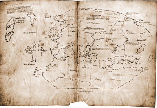
▻https://providencepubliclibrary.tumblr.com/post/166253432007/maybe-the-best-document-mysterycontroversy-ever
Maybe the best document mystery/controversy ever
• une compilation de 10 cartes médiévales (dont certaines en doublon par rapport au reste de la liste et d’autres-les mêmes déjà passées par ici)
Ten Beautiful Medieval Maps
▻http://www.medievalists.net/2013/07/ten-beautiful-medieval-maps
• la carte du monde de Walsperger

Andreas Walsperger’s World Map, 1448
(oriented with South at the top)
57.5 cm diameter
▻http://cartographic-images.net/Cartographic_Images/245_Walspergers_World_Map.html
• la mappemonde de Zeitz
▻https://www.unibw.de/inf4/professuren/photo/persphoto/kleim/arbeitsschwerpunktekleim/zeitz/zeitzer-weltkarte-1470.jpg/image
Angewandte Informatik
▻https://www.unibw.de/inf4/professors/vc-en/staff/kleim/activities/zeitz-en/index_html
• la mappemonde de Ebstorf

▻http://www.henry-davis.com/MAPS/EMwebpages/224mono.html
• la mappemonde de Hereford

avec une version reconstituée, consultable en 2048 x 2048
A 12th century Mappa Mundi, or map of the world, re-created for a major project at Dover Castle in which a suite of royal rooms originally built by King Henry II is undergoing a sumptuous re-creation. Photography : David Burges. | William Cowley
▻http://www.williamcowley.co.uk/uses/calligraphy-illumination/attachment/a-12th-century-mappa-mundi-or-map-of-the-world-re-created-for-a-maj

