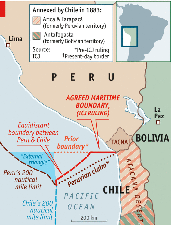
Chile and Peru to present redrawn maps to the UN
Peru have decided to jointly present maps delineating the countries’ maritime boundary to the United Nations (UN), according to Chilean Foreign Minister Heraldo Muñoz. The new maps have been adjusted to reflect the decision of the International Court of Justice, which ruled in favour of Peru regarding their disputed maritime boundary on January 27, 2014.
Muñoz did not mention the recent controversy over the map regarding the still-unclear land border between the two countries. When the new maps were officially unveiled in Lima, the Peruvian maps showed a disputed area of land adjacent to the disputed maritime area known as the ‘land triangle’ to be Peruvian territory. Chilean authorities rejected the Peruvian map, arguing that Chile controlled the land triangle. However, Muñoz claimed that the maps marking the maritime boundary would be presented to the UN despite the controversy, stating that, “the map presented by Peru showing the disputed territory as theirs is unrelated to the works produced on the maritime border by our two nations’ joint team.”
▻https://www.dur.ac.uk/ibru/news/boundary_news/?itemno=22227&rehref=%2Fibru%2F&resubj=Boundary+news+Headlines
#Chili #Pérou #frontières
cc @reka