Stanford historian sees new perspectives on Chinese border disputes

/declassified-chinese-maps-052914.html

  • The Cartography Of Geopolitical Chaos | Co.Design | business + design

    http://www.fastcodesign.com/3031217/the-cartography-of-geopolitical-chaos?partner

    Every map in some way reflects the biases of how its cartographer sees the world—enforcing the arbitrary notion that north should be at the top of the map, or skewing our perception of how big Africa really is. Sometimes, these cartographical biases even shape political borders.

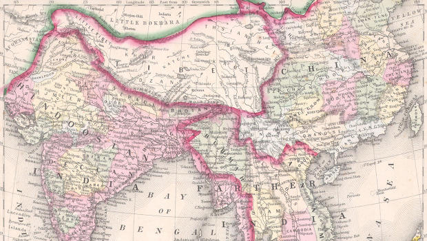
    Starting in 1885, the British (who colonized Burma) spent decades negotiating over the border between Burma, its colony, and Burma’s northern neighbor, China. The two countries’ very different approaches to cartography in the late 19th century played a role in shaping the border, according to new research from Eric Vanden Bussche, a Ph.D candidate in history at Stanford University.

    –—

    Stanford historian sees new perspectives on Chinese border disputes
    http://news.stanford.edu/news/2014/may/declassified-chinese-maps-052914.html

    Chinese historical maps are a bit like gold for scholars. A limited number exist, and China’s government restricts access to many of those dealing with sensitive topics, like border disputes.

    One collection of rare maps used in Sino-Burmese border negotiations during the 19th century was taken to Taiwan during the communist revolution of 1949. There the maps, declassified by the Taiwanese government in 2007, remained unnoticed in basement archives.

    #cartographie #histoire #asie #chine #birmanie #visualisation

    • He suspected the maps might be in Taiwan or Beijing, the two major archives of Chinese historical materials, but since they had not been catalogued, there was no way to request them. Given China’s restrictions on archival access, he had little hope of seeing them if they were housed in Beijing.

      I was wrapping up my research in Taiwan,” Vanden Bussche remembers. “I had gone to the National Palace Museum to look at a late 16th century map.” Rather than the map he had ordered, the archivist mistakenly brought him a 19th century Sino-Burmese border map. It was exactly the type of map he had given up hope of finding.

      So I asked the head map archivist, ‘Do you have more of these?’ ” Vanden Bussche said. “Over the next two weeks he brought me about a dozen maps from that period.

      Because they hadn’t been digitized, making copies was not possible, so Vanden Bussche sketched the maps in his notebook. “Some of them were huge. They took up a whole conference table.” Many of the maps were literally falling apart.

      The collection Vanden Bussche viewed in Taiwan included not only the original Chinese maps, but also British maps of the region with detailed notes in Chinese, added by the Qing negotiators and surveyors.

      “Xue [Fucheng]was aware that the map was the medium through which the Europeans constructed and negotiated space. He had to use a map rather than written sources to advance Chinese territorial claims.”