SWAC - OECD
/swac
-
-
SURFACE WATER IN AFRICA
▻http://www.oecd.org/swac/maps/34-eaudesurface.pdf
Via Laurent Jégou sur Twitter
Few indicators offer a more mixed picture of Africa than that of waterways. Represented according to their permanent
or seasonal nature, African waterways seem to cut the continent into a succession of zones of unequal thickness.
North of the Equator, the Atlas forms a narrow humid strip facing the Saharan expanses, which cover almost a third
of the continent and whose numerous wadis, dried out since the late Neolithic, fl ow only episodically. South of the
Sahara, permanent watercourses dominate, except in the Horn and the Kalahari. Only a handful of rivers born in the
Great Lakes Region (Nile), Ethiopian plateaus (Juba, Sheebele) and the Drakensberg (Orange) manage to cross the arid
dams of the Sahara, Somalia and Namibia. Limited to surface water, the map cannot show the existence, sometimes
considerable as in the Sahara, of underground reserves that were formed millennia ago and give witness to more
favourable climatic episodes. -
Security implications of climate change in the Sahel (SICCS) - OECD
▻http://www.oecd.org/swac/ourwork/siccs.htm
nternational policymaking has over recent years placed climate change impacts as a key threat to state and global stability. The “Security implications of climate change in the Sahel” (SICCS) project, was carried out in 2009-2010 by the SWAC Secretariat. It combined climate, historical, geographical and socio-economic research to analyse the relation between climate change and security in the Sahel. This region is considered particularly vulnerable and is gaining increasing attention due to security, energy and broader geopolitical interests. > executive summar
-

Fruits d’une histoire relativement récente, près de 17 000 km de lignes frontalières traversent les espaces saharo-sahéliens. Cela équivaut – mis bout-à-bout – à plus de 40% de la circonférence de la terre. Si ces lignes ne sont pas des obstacles aux circulations humaines, elles demeurent le symbole de fortes démarcations politiques et institutionnelles, entre le Maroc et l’Algérie par exemple, mais aussi entre les espaces géopolitique du Maghreb et de l’Afrique subsaharienne.
-
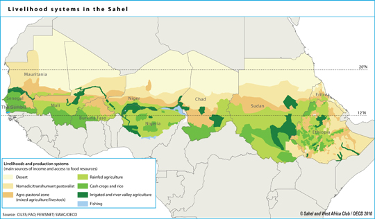
L’OCDE a produit un atlas complet sur la région, il est absolument remarquable.
▻http://www.oecd.org/fr/csao/publications/un-atlas-du-sahara-sahel-9789264222335-fr.htm
-