/4096-2731-max-4-1024x683.jpg

  • Des appareils de #surveillance de #Frontex sont utilisés par les #gardes-côtes_libyens pour intercepter illégalement des migrants

    « Le Monde » a identifié l’origine de sept images aériennes publiées par les gardes-côtes libyens sur leurs pages Facebook. Elles ont été réalisées par des appareils de surveillance de Frontex, et démontrent comment les activités de l’agence européenne facilitent des interceptions illicites par les Libyens en Méditerranée. Frontex a toujours soutenu ne pas collaborer avec les garde-côtes libyens.

    « Le patrouilleur Fezzan a porté secours à un chalutier en feu et a sauvé son équipage de huit personnes. » Le 24 août 2021, la page Facebook « Gardes-côtes et sécurité portuaire » publie le bilan d’une opération de sauvetage menée au cours de la journée par les gardes-côtes libyens.

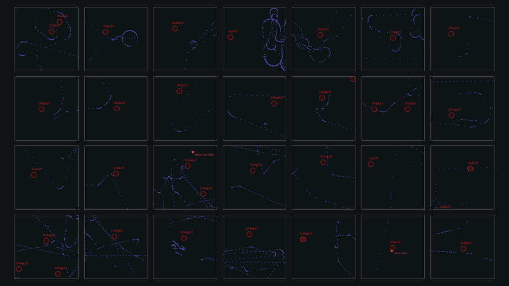
    La présence d’informations temporelles et de localisations sur l’image indique qu’il s’agit d’une prise de vue réalisée par un appareil de surveillance aérienne, et non par un simple appareil photo. Ce genre d’images, entre 2018 et 2022, les gardes-côtes libyens en ont publié une douzaine, sur différents comptes et réseaux. Sauf que la Libye n’est pas dotée d’appareils capables de réaliser ces images. Qui en est à l’origine ?

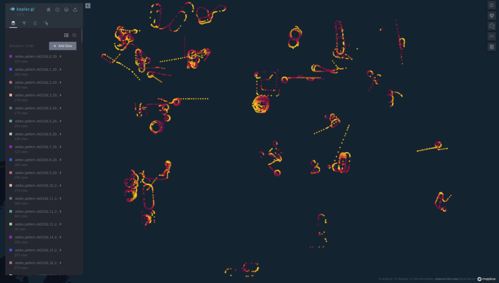
    Pour identifier leur source, Le Monde a recoupé les informations qu’elles contiennent avec des données ADS-B, un signal émis par les avions en vol, ainsi qu’avec les journaux de bord de plusieurs ONG actives en Méditerranée, dans les airs ou en mer. Dans le cas du 24 août 2021, par exemple, les informations présentes sur l’image indiquent les coordonnées, l’altitude et l’heure précise à laquelle l’appareil se trouvait lorsqu’il a réalisé cette image. Elles donnent aussi la position approximative du chalutier observé par l’appareil.

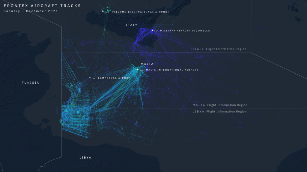
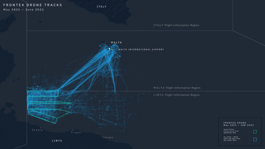
    Nous avons reconstitué le trafic aérien au-dessus de la Méditerranée dans la matinée du 24 août 2021. En comparant les parcours des différents appareils avec les données disponibles sur l’image, nous avons ainsi pu identifier un appareil qui se trouvait précisément aux coordonnées et à l’altitude à laquelle la photo a été prise, lorsqu’elle a été réalisée : le drone AS2132, opéré par Frontex.

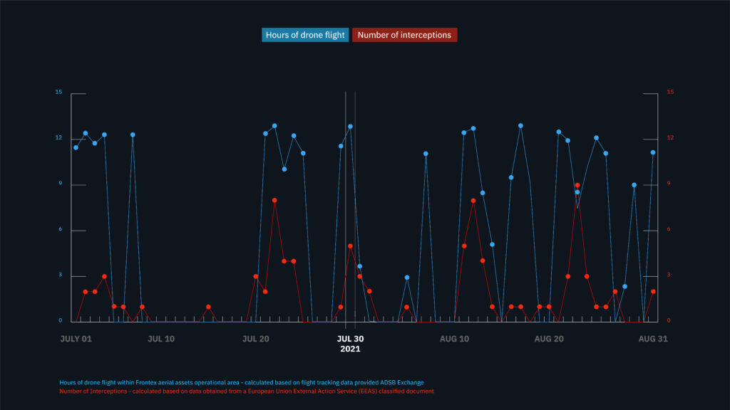
    Pour d’autres images, nous avons eu accès aux observations d’ONG, comme SeaWatch ou SOS Méditerranée, consignées dans des journaux de bord. Ceux-ci sont librement accessibles ici. Au total, ce travail nous permet d’affirmer que sur cinq dates différentes les images publiées par les gardes-côtes libyens ont été réalisées par des appareils de Frontex. Au moins une autre l’a été par un appareil de l’EunavforMed, la force navale européenne en Méditerranée, qui collabore avec Frontex.

    Des interceptions impossibles sans renseignements extérieurs

    Sollicitée, l’agence de garde-frontière l’assure : « il n’y a pas de collaboration entre Frontex et les gardes-côtes libyens », ce qu’affirmait déjà en mars 2021 son ex-directeur Fabrice Leggeri.

    L’agence précise, en revanche : « Chaque fois qu’un avion de Frontex découvre une embarcation en détresse, une alerte – et une image, le cas échéant – est immédiatement envoyée au centre de coordination des sauvetages régional. L’information envoyée inclut notamment la position, la navigabilité du navire et la probabilité qu’il n’atteigne pas sa destination finale. »

    De fait, dans les cinq cas identifiés par Le Monde, les images de Frontex ont pourtant bien fini entre les mains des gardes-côtes libyens. Et certaines ont vraisemblablement rendu possible l’interception d’embarcations, autrement impossibles à localiser pour les Libyens. Dans le cas du 8 mai 2019, par exemple, l’avion de Frontex découvre une embarcation en route pour l’Europe en Méditerranée centrale. Un contact est établi entre les autorités libyennes et l’agence, mais il n’émet pas de Mayday. Ce message d’urgence aurait pu être capté par tous les avions et navires à proximité à ce moment-là, dont le Mare Jonio, de l’ONG Mediterranea Saving Humans, spécialisé dans le sauvetage. Frontex dit n’envoyer des Maydays que « lorsqu’il existe un danger imminent pour la vie des occupants ».

    Les gardes-côtes libyens retrouvent finalement sans difficulté l’embarcation, pourtant située à plus d’une centaine de kilomètres de leurs côtes. A 17 heures, ils font monter les migrants à bord de leur patrouilleur avant de les rapatrier en Libye. Une interception que les informations de Frontex ont vraisemblablement facilitée, voire rendue possible. Pendant toute la durée de l’opération, l’avion de Frontex continue de survoler la zone, et de filmer la scène. Des images auxquelles les gardes-côtes ont aussi eu accès.

    Frontex souligne que, conformément au règlement européen relatif à la surveillance des frontières maritimes extérieures, ses alertes ne sont pas adressées aux gardes-côtes libyens, mais au « centre régional de coordination des sauvetages (#RCC) [libyen] (…) internationalement reconnu ». Une fois l’alerte envoyée, « Frontex ne coordonne pas les opérations de recherche et de sauvetage (...), c’est la responsabilité des centres de secours régionaux« . Reste à savoir si ce RCC existe réellement. Frontex s’en tient à la position de l’Organisation maritime internationale (OMI), qui a reconnu officiellement l’existence d’un RCC en 2018.

    Plusieurs enquêtes ont pourtant mis en doute l’existence d’un tel RCC libyen. Derrière les adresses e-mail et les numéros de téléphone du RCC se trouvent en réalité les gardes-côtes, selon les différentes ONG impliquées dans des opérations de sauvetage en mer Méditerranée. Et le 8 novembre 2022, le vice-président de la commission européenne, Josep Borrell, lui-même affirmait : « Le centre de coordination des secours maritime n’est pas encore opérationnel. »

    Parmi les règles européennes, que Frontex dit respecter, figure le principe du non-refoulement : « Nul ne peut être (…) débarqué, forcé à entrer, conduit dans un pays ou autrement remis aux autorités d’un pays où il existe (…) un risque sérieux qu’il soit soumis à la peine de mort, à la torture, à la persécution ou à d’autres peines ou traitements inhumains ou dégradants. » Des situations courantes en Libye, de sorte qu’en 2020 la Commission européenne affirmait que le pays n’était pas un « lieu sûr » vers lequel il serait possible de renvoyer des migrants. Dans un rapport de 2018, l’ONU constatait que « les migrants subissent des horreurs inimaginables en Libye (…). Ils s’exposent à des meurtres extrajudiciaires, à la torture et à des mauvais traitements, à la détention arbitraire (…), au viol (…), à l’esclavage et au travail forcé, à l’extorsion et à l’exploitation ».

    https://www.lemonde.fr/international/article/2022/11/23/enquete-comment-des-appareils-de-surveillance-de-frontex-sont-utilises-par-l
    #frontières #migrations #asile #réfugiés #Méditerranée #Libye #mer_Méditerranée #pull-backs #pull-back #push-backs

    • Airborne Complicity – Frontex Aerial Surveillance Enables Abuse

      Over the last year, we have partnered with Human Rights Watch to investigate the use by the EU’s border agency, Frontex, of aerial surveillance in the central Mediterranean. The aircraft, several planes and a drone operated by private companies, transmit video feeds and other information to a situation centre in Frontex headquarters in Warsaw, where operational decisions are taken about when and whom to alert about migrants’ boats. Frontex aerial surveillance is key in enabling the Libyan Coast Guard to intercept migrant boatsand return their passengers to Libya, knowing full well that they will face systematic and widespread abuse when forcibly returned there.

      To circumvent Frontex’s lack of transparency on these issues (in processing 27 of 30 freedom of information requests we submitted – the others are pending – Frontex identified thousands of relevant documents but released only 86 of them, most of which were heavily redacted) we cross-referenced official and open-source data, including drone and plane flight tracks, together with information collected by Sea-Watch (through its various search and rescue ships and planes operating in the area), the Alarm Phone, as well as the testimony of survivors who courageously shared their stories with us. 

      Overall, contrary to Frontex claim that its aerial surveillance saves lives, the evidence gathered by Human Rights Watch and Border Forensics demonstrates it is in service of interceptions by Libyan forces, rather than rescue. While the presence of Frontex aircraft has not had a meaningful impact on the death rate at sea, we found a moderate and statistically significant correlation between its aerial assets flights and the number of interceptions performed by the Libyan Coast Guard. On days when the assets fly more hours over its area of operation, the Libyan Coast Guard tends to intercept more vessels.

      Our reconstruction of the events of July 30, 2021, when several boats carrying migrants were intercepted by the Libyan Coast Guard in the area where the drone was patrolling, is a good demonstration of this. The evidence we collected strongly suggests that the droneplayed a key role in facilitating the interception of potentially hundreds of people. 

      The analysis of available data supports the conclusion that the Frontex aerial surveillance forms a central plank of the EU’s strategy to prevent migrants and asylum seekers from reaching Europe by boat and to knowingly return them to unspeakable abuse in Libya. It should be understood in continuity with the progressive withdrawal of EU ships from the central Mediterranean, the handover of responsibility to Libyan forces, and the obstruction of nongovernmental rescue groups which we have been investigating in the frame of the Forensic Oceanography project since several years. 

      The retreat of rescue vessels from the central Mediterranean and the simultaneous increase of surveillance aircraft in the sky is yet another attempt by the EU to further remove itself spatially, physically, and legally from its responsibilities: it allows the EU to maintain a distance from boats in distress, while keeping a close eye from the sky that enables Libyan forces to carry out what we have previously referred to as “refoulement by proxy”. Our investigation seeks to re-establish the connection between Frontex aerial surveillance and the violence captured migrants face at sea and in Libya thereafter.
      Reconstructing 30 July 2021 

      Since the beginning of our research, we have been looking into a number of specific cases of interceptions that involved European aerial assets. Thanks to the relentless effort of documentation by civil society organisations active in the central Mediterranean, in particular the Alarm Phone and Sea Watch, we were able to put together an extensive list of such cases. 

      We eventually decided to focus on the events of July 30, 2021 as a case study. In order to reconstruct what happened on that day, we have combined witness testimonies, data and footage collected by Alarm Phone and Sea Watch, tracks of aerial and naval assets, open-source information and data about disembarkation in Libya as well as two separate databases of interceptions (Frontex’ own JORA database and information from two European Union External Action Service classified documents). 

      Frontex drone’s tracks that day indicate it most likely detected at least two boats later intercepted by the Libyan Coast Guard. The rescue ship Sea-Watch 3 witnessed by chance the interception of one of them that took place within the Maltese Search and Rescue Area. The Sea-Watch 3 had not received any distress alert via Frontex despite being in the immediate vicinity of the boat and ready to assist its passengers. 

      Frontex’ own database admits that its aerial surveillance program detected a total of 5 boats on that day. While only further disclosure by Frontex would allow to ultimately assess its impact on each specific interception that took place on that day, the precise geographical coordinates for the five interceptions reported in the classified EEAS documents seem to match at least three peculiar flight patterns of the Frontex drone.
      Analysing Frontex aerial surveillance
      Flight tracking

      In parallel to case reconstructions, we have been tracking the overall activities of Frontex aircraft in the central Mediterranean. Since these planes and drone are chartered from private companies such as DEA Aviation and ADAS, a subsidiary of Airbus, there is no publicly available official list of such assets. The first task was to understand which were the aerial assets patrolling the central Mediterranean on behalf of Frontex. Cross-referencing various identification information (hexcodes, callsigns, etc.) of these planes with those that had been already identified by Sea Watch airborne team and various journalists allowed us to establish a dependable list of Frontex aerial assets operating in the area. 

      Once that was established, we acquired from ADS-B Exchange (the only flight tracking platform that does not block any aircraft for which data is received by their feeders) a large dataset of flight tracking data covering a period of several months (May 2020 to September 2022) for all these aircraft. While the low number of data feeders near our area of interest means that coverage of the recorded data is at times inconsistent, ADS-B flight tracking data (which include latitude, longitude, altitude, and several other parameters) provide an exceptional insight into aerial activities performed by these assets and became a key element in our investigation.

      Thanks to these data, we were able to visualize the extend of each assets operational area over time. Each of these aircraft monitors a specific area of the central Mediterranean. What emerged were also a series of clearly identifiable and consistent search patters that Frontex aircraft are flying off the coast of Libya. More generally, these visualisations have allowed to grasp the extensive, yet tightly knit web of surveillance that results from aerial operations. 

      Pattern analysis

      When observed closely, flight tracks can provide further precious insights into Frontex surveillance activities. Several loops, U-turns, perfect circles, and sharp corners starts to emerge against the strict geometry of standard search patterns. These deviations indicate an aircraft is taking a closer look at something, thus testifying to potential sightings of migrant boats. Inspired by similar projects by John Wiseman, Emmanuel Freundenthal and others, we then started to isolate and taxonomise such search patterns and then wrote code to automatically identify similar patterns across the whole flight tracking dataset we had acquired. While this aspect of the research is still ongoing, it was already very useful in reconstructing the events of July 30, 2021, as detailed in the following section.

      Statistical analysis

      In order to assess the overall impact of aerial surveillance, we also conducted statistical analysis exploring the relation between interceptions carried out by Libyan forces and the presence of Frontex’s aerial assets in the 2021-2022 timeframe. 

      We first compiled several statistical data sources (data from the IOM, the UNHCR, the Maltese government as well as Frontex’ JORA database and a classified report by the European External Action Service) which, despite inconsistencies, have allowed us to measure migrant crossings and deaths, Libyan Coast Guard interceptions, and Frontex aerial presence. 

      The data gathered shows that Frontex aerial surveillance activities have intensified over time, and that they have been increasingly related to interception events. Our analysis reveals that almost one third of the 32,400 people Libyan forces captured at sea and forced back to Libya in 2021 were intercepted thanks to intelligence gathered by Frontex through aerial surveillance. Frontex incident database also shows that while Frontex’s role is very significant in enabling interception to Libya, it has very little impact on detecting boats whose passengers are eventually disembarked in Italy and Malta. 

      We then tested the correlation between Frontex aerial presence and Libyan Coast Guard interceptions over time and in space. The results show a moderate-to-strong and statistically significant correlation between the number of interceptions and the hours of flight flown by Frontex aerial assets. Said otherwise, on days when the assets fly more hours over its area of operation, the Libyan Coast Guard tends to intercept more vessels. A spatial approach showed that interceptions and flight tracks are autocorrelated in space. At the same time, contrary to Frontex claims that aerial surveillance saves lives at sea, the analysis shows that there is no correlation between death rate and the flight time.

      Read the full statistical analysis here
      Conclusion

      Ultimately these different methods have allowed us to demonstrate how Frontex aerial surveillance (and in particular, because of its wider operational range, its drone) has become a key cog in the “pushback machine” that forces thousands of people back to abuse in Libya. 

      The publication of our findings with Human Rights Watch is the first stage of our ongoing investigation into the impact of European aerial surveillance on the lives and rights of migrants. We plan to continue deepening this investigation over the coming months.


      https://www.borderforensics.org/investigations/airborne-complicity
      #surveillance_aérienne #drones