


Explore The World’s Most Detailed Map Of The Seafloor, Released Today
▻http://io9.com/explore-the-worlds-most-detailed-map-of-the-seafloor-r-1642315933
Researchers today published the most detailed map of the ocean floor ever produced. Data collected by satellites and remote sensing instruments were used to created a model at least twice as accurate as previous maps, revealing thousands of previously uncharted seafloor features in the process. And best of all, you can explore the maps for yourself!
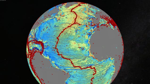
Above: A marine gravity map of the North Atlantic Ocean Red dots show locations of earthquakes with magnitude > 5.5 and they highlight the present-day location of the seafloor spreading ridges and transform faults. This gravity information shows the details of the plate tectonic history of the rifting of these continents including the subtle signatures of fracture zones that are currently buried by sediment. | Image & Caption Credit: David Sandwell, Scripps Institution of Oceanography
Much of what we know about the ocean floor’s topology we know from data collected by multibeam sonar systems. It is estimated that these sonar systems – which have to be lugged back and forth across the ocean’s surface by ships in order to acquire soundings of the seafloor deep beneath them – have left a staggering 90% of the deep-sea bottom uncharted.