Seenthis
•
 
Identifiants personnels
  • [mot de passe oublié ?]

 
  • #a
  • #at
  • #atla
RSS: #atlas

#atlas

  • #atlas2017
  • #atlassian
  • #atlassonore
  • #atlas_
0 | 25 | 50 | 75 | 100 | 125 | 150 | 175
  • @odilon
    odilon @odilon CC BY-NC-ND 20/09/2015
    2
    @reka
    @gastlag
    2

    Trois atlas sur le transport des marchandises en Europe du Nord – Ouest | Blog Histoire – Géo
    ▻https://pierrickauger.wordpress.com/2015/09/16/deux-atlas-sur-le-transport-des-marchandises-en-europe-du-n

    https://pierrickauger.files.wordpress.com/2015/09/pages-de-aurh-weastflows-4.jpg

    Ils sont l’oeuvre de Agence d’Urbanisme de la Région du Havre et de l’Estuaire de la Seine. Le premier est ici et le second est téléchargeable là. Les cartes proposées peuvent servir en lycée, en première, sur le thème « Une façade maritime mondiale : la Northern Range » ou en quatrième pour le chapitre sur « les espaces majeurs de production et d’échange ».

    EDIT : l’agence d’urbanisme m’a contacté pour me signaler l’existence d’un troisième atlas que je n’avais pas vu, téléchargeable ici.

    ▻http://www.aurh.fr/media/aurhatlasweastflowsfancais12092013__066241400_1434_05122013.pdf

    ▻http://www.aurh.fr/media/livrable_3_version_francaise_la__bd__complet__074661700_1056_02072015.pdf

    #atlas #cartographie #transports_de_marchandises

    odilon @odilon CC BY-NC-ND
    • @reka
      Reka @reka CC BY-NC-SA 20/09/2015

      #transport

      Reka @reka CC BY-NC-SA
    Écrire un commentaire
  • @fil
    Fil @fil 16/09/2015

    D3 web maps for static cartography production | Axis Maps Blog
    ▻http://www.axismaps.com/blog/2015/09/d3-web-maps-for-static-cartography-production

    http://www.axismaps.com/blog/wp-content/uploads/2015/09/d3-static-map.jpg

    Here’s a shot of the tool. It looks rough, certainly, but it does its job: quickly get a country map as close as possible to final form, ready to be dropped into our Illustrator and InDesign templates.

    #cartographie #D3 #atlas

    Fil @fil
    • @joelgombin
      joelgombin @joelgombin CC BY-NC 16/09/2015

      L’idée est sympa, dommage que leur outil n’ait pas l’air d’être open source (ni même public) :/

      joelgombin @joelgombin CC BY-NC
    Écrire un commentaire
  • @odilon
    odilon @odilon CC BY-NC-ND 12/09/2015
    1
    @reka
    1

    Grand Atlas des empires coloniaux - La Cliothèque
    ▻http://clio-cr.clionautes.org/grand-atlas-des-empires-coloniaux.html

    http://clio-cr.clionautes.org/IMG/jpg/351x499xgrand_atlas_copie.jpg.pagespeed.ic.JbvOEl7dO8.jpg

    Un volumineux atlas de 287 pages et une ambitieuse mise à jour à la lumière des derniers travaux de recherche de Christophe Colomb jusqu’aux émeutes urbaines de 2005 en France, héritage colonial. L’ouvrage se présente comme un projet d’histoire globale en écho au thème des Rendez-vous de Blois en octobre prochain : Les empires.

    L’ouvrage est organisé en trois grandes périodes chronologiques : Premières #colonisations - #Empires_coloniaux - #Décolonisations, l’ensemble est complété d’une utile chronologie et d’une abondante bibliographie.

    Un titre incontournable qui devrait être dans tous les CDI.

    Chaque partie, organisée en 4 chapitres, est introduite par un texte de présentation de la période au ton souvent novateur. Chaque carte ou graphe est inséré dans un texte qui fait le point sur le thème retenu.

    #livre

    odilon @odilon CC BY-NC-ND
    • @cdb_77
      CDB_77 @cdb_77 12/09/2015

      #colonialisme #atlas #empire_colonial

      CDB_77 @cdb_77
    Écrire un commentaire
  • @cdb_77
    CDB_77 @cdb_77 10/08/2015
    2
    @reka
    @02myseenthis01
    2
    @reka @visionscarto

    Critical Atlas

    We are a collective of critical cartographers and intent to put together a “critical atlas.” On this behalf we invite cartographers, mappers, artists, activists, geographers and everyone who deals with critical maps, to contribute maps, texts, photographs and ideas. Beside printed and digital maps, we plan to integrate reports of mapping initiatives or exhibitions as well as interviews or articles about mappings. We look forward to contributions and suggestions from all parts of the world.

    ▻http://kritische-karten.net/index.php/call-for-papers-english
    –-> Tu connais, @reka, j’imagine, vu qu’ils te citent en premier!
    #atlas #cartographie_critique

    Ils sont à la recherche de contributeurs:
    We are a collective of german critical cartographers and intent to put together a “critical atlas.” On this behalf we invite cartographers, mappers, artists, activists, geographers and everyone who deals with critical maps, to contribute maps, texts, photographs and ideas. Beside printed and digital maps, we plan to integrate reports of mapping initiatives or exhibitions as well as interviews or articles about mappings. We look forward to contributions and suggestions from all parts of the world.
    –-> mais nous, on a VisionsCarto! :-)
    –-> @visionscarto: peut-être une collaboration possible? D’autant plus que leur site ne semble pas être dispo en français?

    CDB_77 @cdb_77
    • @reka
      Reka @reka CC BY-NC-SA 10/08/2015

      Je vais les contacter pour en savoir un peu plus sur leur projet.

      Reka @reka CC BY-NC-SA
    Écrire un commentaire
  • @reka
    Reka @reka CC BY-NC-SA 30/05/2015
    1
    @jcfichet
    1

    The Power of Maps - Part Two

    ▻http://www.timesatlas.com/category/The+Power+of+Maps+-+Part+Two

    http://www.timesatlas.com/file/BKUdh2L/37d41e90-249e-4dbb-b468-f47ad680baaf.jpg

    In 1973 Peters called for a ‘new cartography’ to challenge what he regarded as neo-imperialist world mappings, noting the importance of showing continents in their true size relative to each other, to ensure the developing world was treated fairly. To make his point he inevitably contrasted his equal-area map with those based on the standard Mercator projection – which greatly exaggerates the size of land masses in the higher latitudes, at the expense of those in the tropical regions, home to the majority of developing countries – and rejected the use of other equal-area maps which used curved lines of longitude. His projection certainly draws attention to the global ‘South’, specifically Africa, due to the distinctive shapes given to the continents. However, it has almost invariably been published with Europe as top-centre and cannot really be said to subvert hegemonic representations. Despite the fact that the projection was not particularly innovative (being just one of a family of equal-area maps), Peters managed to convince many charities and even the United Nations to adopt it as the politically correct map for development education.

    #cartographie #atlas #projections #pouvoir

    • #The Times
    • #AFRICA
    • #Europe
    • #United Nations
    Reka @reka CC BY-NC-SA
    • @reka
      Reka @reka CC BY-NC-SA 30/05/2015

      Et bien sur :

      The Power of Maps - Part One

      ▻http://www.timesatlas.com/category/The+Power+of+Maps+Part+One

      The Power of Maps - Part One

      Published 23rd April 2015 by The Times Atlas

      Maps are an extremely powerful form of graphic representation. Maps define territory – they tell of ownership and dominion, they marshal spatial information. They can also subvert and propagate alternative world-views. All maps serve an interest and work through two main forms of power.

      First, the external power of their creators, often governments or their agents, who control the content of maps both in terms of what is included and what is withheld, and thereby broadcast a particular viewpoint. Second, the internal power of maps themselves – the perception of maps as precise, objective and accurate representations of reality which convey an image of geographical order.

      Maps are still regarded by many people as dispassionate representations of the external world. However, this has been challenged in recent decades as their political and cultural connotations are revealed and become more widely understood.

      Reka @reka CC BY-NC-SA
    • @fil
      Fil @fil 30/05/2015

      #projections

      Fil @fil
    Écrire un commentaire
  • @ville_en
    Ville En Guerre @ville_en 6/05/2015
    3
    @reka
    @odilon
    @gastlag
    3

    Parution en ligne : Le Monde des Cartes (Bulletin du Comité français de Cartographie, n°221, 2014)

    Pas de lien direct pour l’ensemble de l’ouvrage en ligne (découpé par chapitre). A retrouver sur le site du Comité Français de Cartographie : ▻http://www.lecfc.fr/index.php?page=publication

    Ou par chapitres :

    Le Monde des Cartes - Préface ▻http://www.lecfc.fr/new/articles/221-article-1.pdf
    Le Monde des Cartes - Avant-propos ▻http://www.lecfc.fr/new/articles/221-article-2.pdf
    Chapitre 1 : Cartographie ▻http://www.lecfc.fr/new/articles/221-article-3.pdf
    Chapitre 2 : Usage et lecture des cartes ▻http://www.lecfc.fr/new/articles/221-article-4.pdf
    Chapitre 3 : L’information géographique ▻http://www.lecfc.fr/new/articles/221-article-5.pdf
    Chapitre 4 : Conception cartographique ▻http://www.lecfc.fr/new/articles/221-article-6.pdf
    Chapitre 5 : Cartes topographiques ▻http://www.lecfc.fr/new/articles/221-article-7.pdf
    Chapitre 6 : Cartes thématiques ▻http://www.lecfc.fr/new/articles/221-article-8.pdf
    Chapitre 7 : Atlas ▻http://www.lecfc.fr/new/articles/221-article-9.pdf
    Chapitre 8 : Toponymes ▻http://www.lecfc.fr/new/articles/221-article-10.pdf
    Chapitre 9 : Projections cartographiques et systèmes de référence ▻http://www.lecfc.fr/new/articles/221-article-11.pdf
    Chapitre 10 : Utilisation de la carte aux Nations Unies ▻http://www.lecfc.fr/new/articles/221-article-12.pdf
    Chapitre 11 : Trouver son chemin avec une carte marine ▻http://www.lecfc.fr/new/articles/221-article-13.pdf
    Chapitre 12 : Cartes pour l’orientation et la découverte d’objets cachés ▻http://www.lecfc.fr/new/articles/221-article-14.pdf
    Chapitre 13 : Impression des cartes ▻http://www.lecfc.fr/new/articles/221-article-15.pdf
    Chapitre 14 : Cartographie Web et mobiles ▻http://www.lecfc.fr/new/articles/221-article-16.pdf
    Chapitre 15 : Information géographique, accès et mise à disposition ▻http://www.lecfc.fr/new/articles/221-article-17.pdf
    Chapitre 16 : Information géographique collaborative ▻http://www.lecfc.fr/new/articles/221-article-18.pdf
    Chapitre 17 : Enseigner la cartographie ▻http://www.lecfc.fr/new/articles/221-article-19.pdf
    Chapitre 18 : Plus d\’informations ▻http://www.lecfc.fr/new/articles/221-article-20.pdf

    #Géographie #Cartographie #Information_Géographie #Géographie_et_Cartographie #Cartes #Représenter_l_Espace #Toponymie #Atlas #Cartes_Thématiques #Cartes_Topographiques #Cartes_Marines #Cartographie_Web #Enseigner_la_Cartographie #Projections_Cartographiques

    • #le Monde
    Ville En Guerre @ville_en
    • @reka
      Reka @reka CC BY-NC-SA 6/05/2015

      Merci Béné, très intéressant d’avoir ces textes. j’en connaissais certains, et j’ai parcouru quelques autres. Il y aurait vraiment matière à débattre (si on avait le temps).

      Mais je profite de ce signalement pour rappeler qu’en 2008, il y a eu à Vienne un symposium sur les rapports entre « art et cartographie ». Je me souviens que pendant deux ou trois jours, scientifiques et artistes ont bien discuté, mais sont résolument restés sur leurs positions :) c’était parfois assez drôle d’entendre les scientifiques purs et durs, défendre l’orthodoxie de la cartographie qui se doit d’être précise, vraie, neutre et fidèle à la réalité (sic), et les artistes qui utilisent les cartes dans leurs œuvres, qui recherchent tout ce qui peut y être poétique, sensible, émotionnel, qui défendent la subjectivité, l’interprétation, les visions ; l’imaginaire, etc... :)
      `
      A ma connaissance, c’est resté un peu un dialogue de sourd. Il y a eu des communications vraiment sympa, je pense qu’elles doivent être disponibles quelque part sur Internet, à l’occasion, on les exhumera.

      Cette initiative était coordonnées par Georg Gartner and Antje Lehn :

      Art and Cartography – Cartography and Art
      Symposium 1 – 2 February 2008
      Vienna University of Technology, Vienna, Austria

      The International Cartographic Association is forming a new working group on Art and Cartography. It proposes to foster closer collaborations between artists and cartographers. The symposium will bring-together practicing artists, architects and cartographers and those involved in research and education in the fields.

      contributions from Cartography and the Arts addressing the
      topics of:

      – Maps as artistic artefacts

      – Aspects of artistic and graphical expressions with and through maps in cartography (contemporary and historic),

      – Explorations of different interpretations of space and place using New Media and experimental art forms

      – Depicting space with narratives, paintings, graphics, sound, animations, installations, time based media and other non-traditional cartographic artefacts

      Voir :

      ▻https://www.dropbox.com/s/g8mc1vd1z0ssom8/ArtAndCartography_Program.pdf?dl=0

      ▻http://cartography.tuwien.ac.at/artandcartography/index.php?Art_and_Cartography:Statements

      Enfin, ce symposium a donné lieu à la publication d’un bouquin paru chez Springer, je mets le fichier pdf ici pour tous ceux que ça intéresse.

      ▻https://www.dropbox.com/s/ole1dntpwboqr6s/cartographie%20et%20art%20vienne%20__Cartography_and_Art__Lecture_Notes_in_

      #cartographie #art #sémiologie #fondamentaux #cartographie_générale

      Reka @reka CC BY-NC-SA
    Écrire un commentaire
  • @reka
    Reka @reka CC BY-NC-SA 4/05/2015
    3
    @ville_en
    @monolecte
    @geneghys
    3

    An Atlas of Upward Mobility Shows Paths Out of Poverty - NYTimes.com

    ▻http://www.nytimes.com/2015/05/04/upshot/an-atlas-of-upward-mobility-shows-paths-out-of-poverty.html?emc=edit_th_201

    Signalé par ISS ce matin.

    http://graphics8.nytimes.com/newsgraphics/2015/04/21/county-mobility/10fb3d9a9ac25d0720bc539cc2547fd66803a047/linearChart-945.png

    In the wake of the Los Angeles riots more than 20 years ago, Congress created an anti-poverty experiment called Moving to Opportunity. It gave vouchers to help poor families move to better neighborhoods and awarded them on a random basis, so researchers could study the effects.

    The results were deeply disappointing. Parents who received the vouchers did not seem to earn more in later years than otherwise similar adults, and children did not seem to do better in school. The program’s apparent failure has haunted social scientists and policy makers, making poverty seem all the more intractable.

    #cartographie #atlas #new-york #pauvreté #richesse #visualisation

    • #Los Angeles
    • #Congress
    Reka @reka CC BY-NC-SA
    Écrire un commentaire
  • @ville_en
    Ville En Guerre @ville_en 28/04/2015
    4
    @jcfichet
    @unagi
    @gastlag
    @reka
    4

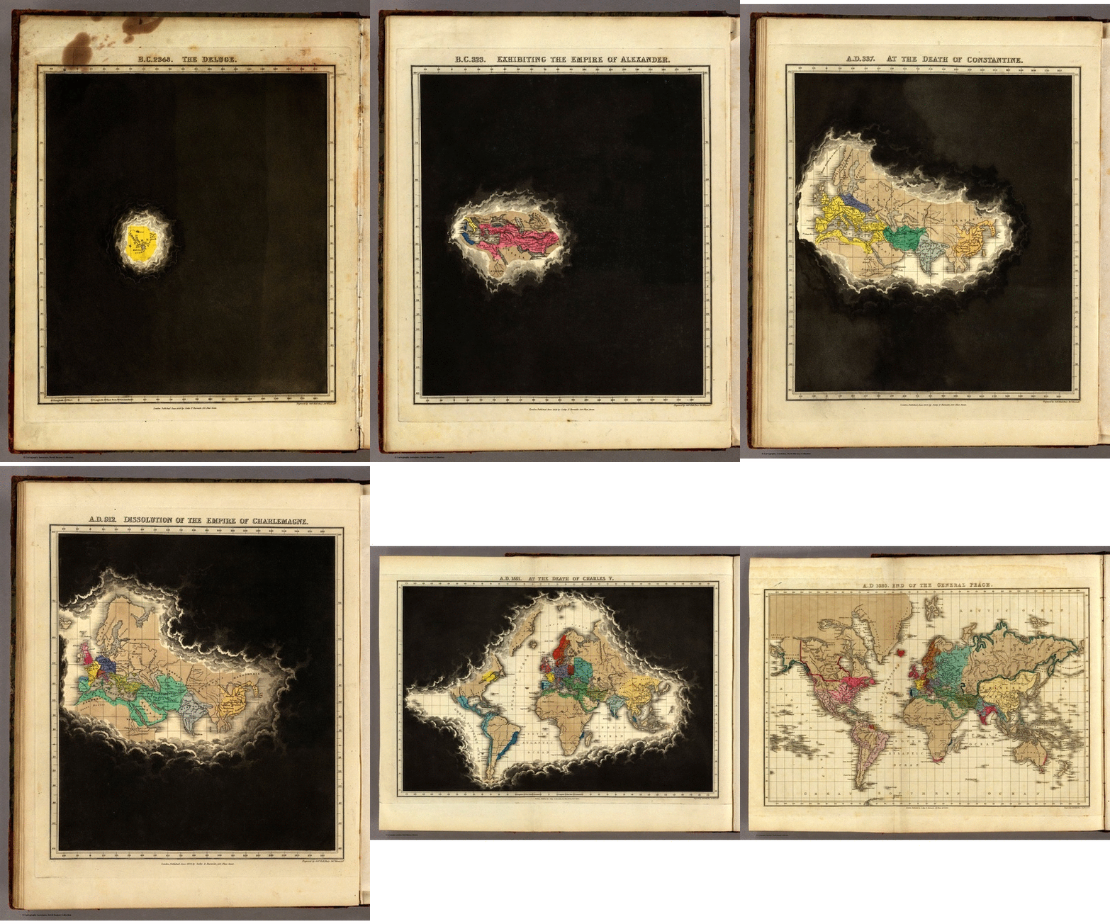
    Un atlas du monde connu en brouillard de guerre publié en 1830
    ►http://www.laboiteverte.fr/un-atlas-du-monde-connu-en-brouillard-de-guerre-publie-en-1830

    #Représenter_l_Espace #Représenter_le_Monde #Géographie #Agrégation_de_Géographie #Atlas #Cartographie #Histoire_de_la_Géographie #Histoire_de_la_Cartographie

    http://www.laboiteverte.fr/wp-content/uploads/2015/04/carte-monde-connu-brouillard-guerre-01.gif

    • #Vincent Capdepuy
    Ville En Guerre @ville_en
    • @jcfichet
      jcfichet @jcfichet 28/04/2015

      Superbe!!

      jcfichet @jcfichet
    • @reka
      Reka @reka CC BY-NC-SA 28/04/2015

      Bravo béné pour cette trouvaille !!

      Reka @reka CC BY-NC-SA
    • @jcfichet
      jcfichet @jcfichet 28/04/2015
      @clioweb

      En complément, cet article de Vincent Capdepuy paru en septembre 2012, signalé par @clioweb sur twitter :

      ▻http://blogs.histoireglobale.com/l%E2%80%99histoire-tunnel-en-diapositives-l%E2%80%99atlas-his

      jcfichet @jcfichet
    Écrire un commentaire
  • @cdb_77
    CDB_77 @cdb_77 25/04/2015

    #Atlas #Savoie #Mont-Blanc

    Dans le contexte de la création de la collectivité territoriale Savoie Mont-Blanc, rapprochement de la Savoie et de la Haute-Savoie, les auteurs s’attachent à analyser les points communs et les spécificités de ces départements aujourd’hui.

    http://www.le-cartographe.net/jupgrade/images/stories/publications/sav_couverture.jpg

    ▻http://www.le-cartographe.net/jupgrade/publications/316-atlas-savoie-mont-blanc
    #cartographie #livre #montagne

    • #Mont
    • #Mont-Blanc
    CDB_77 @cdb_77
    Écrire un commentaire
  • @reka
    Reka @reka CC BY-NC-SA 15/04/2015
    2
    @gastlag
    @geneghys
    2

    Le Cedid Atlas : le premier atlas moderne du monde musulman
    ▻http://www.laboiteverte.fr/le-cedid-atlas-le-premier-atlas-moderne-du-monde-musulman

    http://www.laboiteverte.fr/wp-content/uploads/2015/04/cedid-atlas-carte-musulman-01-1080x736.jpg

    Le Cedid Atlas a été commandé par le gouvernement Ottoman et publié à Istanbul en 1803 en 50 exemplaires dont seulement 10 ont survécus jusqu’à nos jours.

    Son nom complet est « Cedid Atlas Tercümesi », ce qui se traduit par « Une traduction du Nouvel Atlas », une référence au fait que c’est une adaptation d’un Atlas anglais publié par William Faden et il est précédé par une préface de 80 pages sur la géographie.

    #atlas #cartographie #monde_musulman

    • #Istanbul
    Reka @reka CC BY-NC-SA
    Écrire un commentaire
  • @cdb_77
    CDB_77 @cdb_77 7/03/2015
    1
    @reka
    1

    L’#Atlas_Interactif des #Régions Européennes (#AIRE) est un projet de l’UMS 2414 RIATE.

    Au delà d’un simple outil de consultation, l’atlas permet d’avoir accès à de multiples représentations d’un même phénomène grâce à des méthodes d’#analyses_spatiales variées et/ou des représentations cartographiques peu courantes (cartes de potentiels, cartes de discontinuités, carroyages, anamorphoses, ...) selon 5 niveaux de maillage européen différents.

    http://aire.ums-riate.fr/data/home/img/home_fr.png

    ▻http://aire.ums-riate.fr/fr#content/index.fr.php
    #Europe #régionalisation
    #visualisation #cartographie

    • #Europe
    CDB_77 @cdb_77
    Écrire un commentaire
  • @kassem
    Kassem @kassem CC BY-NC-SA 2/02/2015
    2
    @reka
    @odilon
    2

    A French Atlas of the Gulf States
    ▻http://www.jadaliyya.com/pages/index/20067/a-french-atlas-of-the-gulf-states

    http://www.jadaliyya.com/content_images/3/Atlas_Gulf_States.jpg

    Using a more demanding approach, the team of Le Monde Diplomatique and its famous cartographer, Phillippe Rekacewicz, have introduced a series of critical atlases, dealing with globalization, global conflicts, and environmental issues. In so doing, they are subverting the usual canons of mapping, often viewed by its critics as a tool in the hands of (military) powers, rather than an instrument of revolt and awareness. The former is probably the reason that, since the cultural and post-colonial turn of the 1990s, English-speaking academics seem to be wary of such intellectual products, seeing them as instruments of domination that utilize oversimplified—if not altogether flawed—categories intended to impose facts on the ground that in reality do not exist. Indeed, most governmental statistical data contribute to the legitimation of borders that often continue to be irrelevant.

    • #le Monde
    • #Cartographer
    • #Le Monde Diplomatique
    Kassem @kassem CC BY-NC-SA
    • @reka
      Reka @reka CC BY-NC-SA 2/02/2015

      #golfe

      Reka @reka CC BY-NC-SA
    • @cdb_77
      CDB_77 @cdb_77 3/02/2015

      #atlas #cartographie

      CDB_77 @cdb_77
    Écrire un commentaire
  • @odilon
    odilon @odilon CC BY-NC-ND 16/01/2015
    1
    @reka
    1

    Soil Atlas: Facts and figures about earth, land and fields | Heinrich Böll Foundation
    ▻http://www.boell.de/en/2015/01/07/soil-atlas-facts-and-figures-about-earth-land-and-fields
    ▻http://www.boell.de/sites/default/files/styles/420x630_with_cropping/public/uploads/2015/01/soilnatlas_titel_rgb.jpg?itok=hRLYZWmb

    We are using the world’s soils as if they were inexhaustible, continually withdrawing from an account, but never paying in. For it takes several thousand years to build a thin layer of fertile topsoil, but only an hour of heavy rain to lose it. The average European needs 1.3 hectares – two football pitches – to produce all of the food and other products he or she consumes each year. That is about six times more than is available to each Bangladeshi. Almost 60 percent of the area consumed by Europeans lies outside the European Union.

    Global demand for food, fodder and biofuels is on the rise. So too are land prices. In many regions, the struggle for secure land rights is a struggle for survival for individuals and communities. The global significance of soils demands global responses. 2015 is the International Year of Soils. In this year, the United Nations wants to further the goal of soil protection. This Soil Atlas shows what can succeed and why the soil should concern us all.

    The Soil Atlas is available in a printed version and available for download (PDF). All texts and graphics can be used under the Creative Commons Licence CC-BY-SA. The graphics are available as a seperate download (ZIP) as well.

    ▻http://www.boell.de/sites/default/files/soil_atlas_2015.pdf
    #sols #terres #atlas #cartographie

    • #food
    • #European Union
    • #Heinrich Böll Foundation
    odilon @odilon CC BY-NC-ND
    Écrire un commentaire
  • @reka
    Reka @reka CC BY-NC-SA 13/01/2015
    3
    @fil
    @gastlag
    @odilon
    3

    Cartographic Arts: Beautiful Maps From the Atlas of Design | WIRED

    ▻http://www.wired.com/2015/01/beautiful-maps-atlas-of-design

    https://pbs.twimg.com/media/B7PdsVDCEAEysYs.jpg:large

    Many of the maps that go viral on the internet make professional mapmakers cringe due to terrible color schemes, landmass-distorting projections, and amateurish composition. You won’t find any of that nonsense here. The maps in this gallery were selected by a panel of cartographers and designers for the second volume of the Atlas of Design.

    Even so, there’s still an element of subjectivity involved in curating a book of well-designed maps, says Daniel Huffman, a freelance cartographer in Madison, WI, and one of the volume’s three editors, along with Sam Matthews and Marty Elmer. Cartographers submitted nearly 300 maps, and a panel of judges picked 32 to include in the atlas. The focus was on aesthetics, rather than data analysis or other technical aspects of mapmaking. “Every map in the competition had some judges like it and some judges not,” Huffman said. “Not all the styles are to everyone’s taste.”

    Consulter :

    ►http://atlasofdesign.org/one
    et
    ▻http://atlasofdesign.org/two

    #cartographie #design #atlas_of_design #visualisation #cartographie_et_art

    Reka @reka CC BY-NC-SA
    Écrire un commentaire
  • @reka
    Reka @reka CC BY-NC-SA 5/01/2015
    6
    @fil
    @monolecte
    @7h36
    @simplicissimus
    @odilon
    @mdiplo
    6

    The Atlas of Economic Complexity | About

    ▻http://atlas.cid.harvard.edu/about

    The Atlas online is a powerful interactive tool that enables users to visualize a country’s total trade, track how these dynamics change over time and explore growth opportunities for more than a hundred countries worldwide.

    https://dl.dropbox.com/s/27p08di4xeqt9fy/Capture%20d%E2%80%99%C3%A9cran%202015-01-05%20%C3%A0%2021.36.55.png?dl=0

    The Atlas is used by investors, entrepreneurs, policymakers, students and the general public to better understand the competitive landscape of countries around the globe. For any given country, The Atlas shows which products are produced and exported; The Atlas can then use this information to suggest products a country could begin manufacturing in order to fuel economic growth. As a dynamic resource, The Atlas is continually evolving with new data and features to help analyze economic growth and development.

    The Atlas can answer questions such as:

    What does a country import and export?
    How has its trade evolved over time?
    What are the drivers of export growth?
    Which new industries are likely to emerge in a given geography?
    Which are likely to disappear?
    What are the GDP growth prospects of a given country in the next
    5-10 years, based on its productive capabilities?

    #atlas #mondialisation #visualisation #cartographie

    • #manufacturing
    Reka @reka CC BY-NC-SA
    • @freakonometrics
      freakonometrics @freakonometrics 5/01/2015

      tu as vu que le livre était en ligne sur le site ?

      ▻http://atlas.cid.harvard.edu/media/atlas/pdf/HarvardMIT_AtlasOfEconomicComplexity.pdf

      (incroyable)

      freakonometrics @freakonometrics
    • @reka
      Reka @reka CC BY-NC-SA 5/01/2015

      ah merci ! #génial. Oui c’est vertigineux et très riche. Ce qui est bien c’est qu’on peut beaucoup discuter sur les représentations et les choix visuels, c’est très riche. On y reviendra :)

      Reka @reka CC BY-NC-SA
    • @cdb_77
      CDB_77 @cdb_77 6/01/2015
      @franz42

      cc @franz42

      CDB_77 @cdb_77
    • @franz42
      Franz42 @franz42 CC BY-NC 6/01/2015

      je viens de feuilleter mais je n’ai pas vraiment compris si tu peux nous expliquer simplement les graphes (The product space) ?

      Franz42 @franz42 CC BY-NC
    • @reka
      Reka @reka CC BY-NC-SA 6/01/2015

      C’est en effet un peu ésotérique :) mais y a des idées très intéressantes. Pas le temps en ce moment de me pencher plus avant sur cette question, mais on y reviendra.

      Reka @reka CC BY-NC-SA
    Écrire un commentaire
  • @reka
    Reka @reka CC BY-NC-SA 5/01/2015

    Agence d’urbanisme de la région du Havre et de l’Estuaire de la Seine - L’Atlas cartographique des infrastructures européennes de transport

    ▻http://www.aurh.fr/territoire-et-enjeux/l-europe-et-les-programmes-europeens/l-atlas-cartographique-des-infrastructures-europeennes-de-transport

    Disponible en téléchargement pdf. Très intéressant.

    Juin 2013 : publication de l’Atlas des principales infrastructures de transport de marchandises de l’Europe du Nord-Ouest
    AURH - Atlas Weastflows - 130x91

    https://dl.dropbox.com/s/d3pxroo5a8gr6go/Capture%20d%E2%80%99%C3%A9cran%202015-01-05%20%C3%A0%2009.48.32.png?dl=0

    L’atlas, composé de 47 cartes, présente l’organisation du système de transport de marchandises du Nord-Ouest de l’Europe, tous types d’infrastructures (existantes ou en projet) et tous types de marchandises.

    Il propose :

    des cartes de contexte à l’échelle globale de l’Europe du Nord-Ouest exposant les principales caractéristiques démographiques et économiques de la zone et livrant une première description des trafics portuaires ;
    une sélection de cartes présentant les infrastructures par mode de transport et les projets de développement à l’échelle globale ;
    des cartes régionales se concentrant sur l’organisation des réseaux de transport par grande région dont le Seine Gateway®.

    L’atlas est la première étape du projet, il aide à la connaissance détaillée et précise des caractéristiques des réseaux de transport de marchandises.

    #cartographie #atlas #régions_transfrontalières #frontières

    • #Le Havre
    • #Estuaire de la Seine
    Reka @reka CC BY-NC-SA
    • @petit_ecran_de_fumee
      petit-écran de fumée @petit_ecran_de_fumee 5/01/2015

      Euh dans la carte qu’on voit, la Beauce semble plus peuplée que la Bretagne ou la région Lyonnaise... je comprends pas...

      petit-écran de fumée @petit_ecran_de_fumee
    Écrire un commentaire
  • @k1ng0fno0b
    K1ng0fNo0b @k1ng0fno0b 19/12/2014

    Alpenföhn Atlas, un refroidisseur micro ATX et mini ITX | Monhardware.fr
    ▻http://www.monhardware.fr/alpenfohn-presente-le-ventirad-atlas

    Alpenföhn Atlas, un refroidisseur pour configuration micro ATX et mini ITX

    Alpenföhn, la firme spécialisée dans les systèmes de refroidissement pour processeur lance l’Atlas.

    Les Hashtag pour trouver l’information rapidement :

    #Alpenföhn #refroidisseur #Atlas #ventirad #cpu #processeur

    K1ng0fNo0b @k1ng0fno0b
    Écrire un commentaire
  • @reka
    Reka @reka CC BY-NC-SA 29/11/2014
    3
    @goom
    @fil
    @visionscarto
    3

    Experiments in mapping the intangible - Boing Boing

    ▻http://boingboing.net/2014/11/20/experiments-in-mapping-the-int.html

    http://media.boingboing.net/wp-content/uploads/2014/11/tumblr_ne9rfxEoD21t3i99fo1_12801.jpg

    I never tire of the conceptual trick of applying the metaphor of a map onto something non-geographical. Mapping It Out: An Alternative Atlas of Contemporary Cartographies by Hans Ulrich Obrist rounds up a set of maps created by artists and thinkers that chart what is often hard to visualize. The editor labels them “alternative cartographies.

    ▻http://40.media.tumblr.com/b0c00ecae196c45a49b94e9289c1344a/tumblr_ne9rfxEoD21t3i99fo3_1280.jpg”

    Disclosure: one of the entries is mine. Several years ago I began asking people to “draw the internet” on a sheet of paper, and my own map of the internet is included here. That’s the kind of conceptual cartography this atlas contains. I think of this as experiments in mapping the intangible.

    #cartographie #art #cartographie_radicale #atlas #bibliographie

    • #Hans Ulrich Obrist
    • #editor
    Reka @reka CC BY-NC-SA
    • @cdb_77
      CDB_77 @cdb_77 1/12/2014

      #intangible #invisible

      CDB_77 @cdb_77
    Écrire un commentaire
  • @reka
    Reka @reka CC BY-NC-SA 19/11/2014
    3
    @fil
    @visionscarto
    @geneghys
    3

    Social Inclusion Atlas of Nepal: Ethnic And Caste Groups (In 4 Volumes), Tribhuvan University

    ▻http://www.bagchee.com/books/BB88247/social-inclusion-atlas-of-nepal-ethnic-and-caste-groups-in-4-volumes

    Social Inclusion Atlas of Nepal: Ethnic And Caste Groups (In 4 Volumes)

    http://www.bagchee.com/web/files/books/2014/08/88247/thumb_286_79496.jpg http://www.bagchee.com/web/files/books/2014/08/88247/thumb_286_81516.jpg http://www.bagchee.com/web/files/books/2014/08/88247/thumb_286_81514.jpg

    #atlas #cartographie #népal

    • #Nepal
    Reka @reka CC BY-NC-SA
    Écrire un commentaire
  • @cdb_77
    CDB_77 @cdb_77 18/11/2014
    2
    @reka
    @visionscarto
    2

    Une nouvelle #cartographie pour un #monde_global

    Avec 60 #cartes conçues et documentées par une flopée de géographes, d’historiens et de cartographes, l’#Atlas_Global offre une lecture originale, décalée et désoccidentalisée du monde d’aujourd’hui.

    http://www.lesechos.fr/medias/2014/11/07/1062287_une-nouvelle-cartographie-pour-un-monde-global-web-tete-0203923793502_660x308p.jpg

    ▻http://www.lesechos.fr/enjeux/les-plus-denjeux/idees/0203923793280-une-nouvelle-cartographie-pour-un-monde-global-1062287.php?xt

    CDB_77 @cdb_77
    Écrire un commentaire
  • @reka
    Reka @reka CC BY-NC-SA 6/11/2014
    1
    @odilon
    1

    Understanding the World by visualisation. The Atlas of Infographics. TASCHEN Books

    ▻http://www.taschen.com/pages/en/catalogue/design/all/03411/facts.understanding_the_world_the_atlas_of_infographics.htm

    Un nouvel ouvrage sur la visualisation en général, l’infographie, le graphic design et accessoirement la cartographie... C’est pas mal du tout.

    Planet on the page A visual atlas of our vast, fragile world
    Dazzling in scale, diversity and detail, the world never ceases to open our eyes and captivate our curiosity. Ever since the earliest cave paintings, humans have looked at this Earth that is our home and endeavored to understand it.

    http://www.taschen.com/media/images/820/ju_understanding_the_world_top_076_077_1410010950_id_834000.jpg

    This expansive visual atlas presents the most exciting, creative and inspiring ways of explaining the world in information graphics. Divided into five chapters, the book covers the environment, technology, economics, society, and culture to reveal some of the Earth’s greatest intricacies in accessible visual form. Featuring more than 280 graphics, the collection focuses on the 21st century, but also includes historical masterpieces to put our current situation into perspective.

    #taschen #infographie #visualisation #atlas

    Reka @reka CC BY-NC-SA
    Écrire un commentaire
  • @reka
    Reka @reka CC BY-NC-SA 3/11/2014
    1
    @fil
    1

    Atlas of Birth and maternal death

    J’ai reçu il y a deux ou trois ans une petite plaquette qui annonçait la sortie de cet atlas, je l’avais commandé et jamais reçu. Entre temps, je l’ai recherché (mollement il faut bien le dire) sur Internet sans pouvoir le trouver.

    Je publie ici deux cartes et deux graphiques qui - même si les données sont anciennes - restent très intéressants.

    https://dl.dropbox.com/s/s63y912ec84c31u/birth%20atlas%20cover.jpg?dl=0 https://dl.dropbox.com/s/lf77zal396xbfae/birth%20atlas%202.jpg?dl=0 https://dl.dropbox.com/s/v4ucvkfwo59okds/birth%20atlas%203.jpg?dl=0 https://dl.dropbox.com/s/d2bcd2dwvowo7yc/birth%20atlas%201.jpg?dl=0

    #santé #santé_maternelle #enfants #enfance #visualisation #cartographie #atlas #ribbon_alliance

    Reka @reka CC BY-NC-SA
    • @fil
      Fil @fil 3/11/2014

      on en parle ici mais tous les liens sont brisés
      ▻http://www.cnet.com/news/atlas-of-birth-mapping-maternal-health-online

      Fil @fil
    Écrire un commentaire
  • @reka
    Reka @reka CC BY-NC-SA 27/10/2014
    2
    @visionscarto
    @fil
    2

    ciam2014 - Atlas

    ▻https://www.aanmelder.nl/79626/wiki/91824/atlas

    Voilà qui promet d’être bien !

    Summary

    http://thoth.nl/upload/image/373Omslag%20CIAM%20def%20lores.JPG

    (For more detailed information about the book, please visit the website of THOTH-uitgevers.)

    Editors: Evelien van Es, Gregor Harbusch, Bruno Maurer, Muriel Perez, Kees Somer, Daniel Weiss

    Design: Studio Joost Grootens (Amsterdam NL)

    Hardcover, 480 pages, 750 full colour illustrations
    ISBN 978 90 6868 648 7

    During the ciam2014 Conference Atlas of the Functional City will be available for a special introduction price of €69,50 (From 1st January 2015 for €89,50)

    The research project and publication is a joint initiative of the Van Eesteren-Fluck & Van Lohuizen Foundation (EFL), the Archives of the Institute for the History and Theory of Architecture (gta) at ETH Zurich.

    #architecture #atlas #cartographie #visualisation #urban_matter #ciam4 #ciam2014

    • #EUR
    Reka @reka CC BY-NC-SA
    Écrire un commentaire
  • @reka
    Reka @reka CC BY-NC-SA 19/09/2014
    1
    @recriweb
    1

    Un atlas d’Asie du Sud qui a 20 ans (1993) mais de très belle facture

    Digital South Asia Library_ Schwartzberg Atlas

    ▻http://dsal.uchicago.edu/reference/schwartzberg

    http://dsal.uchicago.edu/reference/schwartzberg/logo.jpg

    #inde #asie #asie_du_sud #atlas #cartographie

    • #South Asia
    Reka @reka CC BY-NC-SA
    Écrire un commentaire
  • @mona
    Mona @mona 10/09/2014
    8
    @reka
    @odilon
    @rezo
    @02myseenthis01
    @tastybud
    @7h36
    @rastapopoulos
    @goom
    8

    Subjective Atlas of Palestine
    ▻http://bureaudevet.be/subjectieveatlas/atlas/subjective-atlas-of-palestine

    Sublime landscapes, tranquil urban scenes, frolicking children; who would associate these images with Palestine? All too often the Western media show the country’s gloomy side, and Palestinians as aggressors. It is this that makes identifying with them virtually impossible. If we are to relate to the Palestinians other images are needed, images seen from a cultural and more human vantage point.

    The Dutch designer Annelys de Vet invited Palestinian artists, photographers and designers to map their country as they see it. Given their closeness to the subject, this has resulted in unconventional, very human impressions of the landscape and the architecture, the cuisine, the music and the poetry of thought and expression. The drawings, photographs, maps and narratives made for this atlas reveal individual life experiences, from preparing chickpeas to a manual on water pipe smoking, from historic dress to modern music. Pages containing humorous and caustic newspaper cartoons and invented Palestinian currency followed by colourful cultural diaries and moving letters from prisoners.

    All in all, the contributions give an entirely different angle on a nation in occupied territory. In this subjective atlas it is the Palestinians themselves who show the disarming reverse side of the black-and-white image generally resorted to by the media.

    #Palestine

    • #Palestinian Territories
    • #designer
    Mona @mona
    • @reka
      Reka @reka CC BY-NC-SA 10/09/2014
      @mona

      Merci @mona

      Reka @reka CC BY-NC-SA
    • @mona
      Mona @mona 10/09/2014
      @reka

      @reka Je me disais que ça pourrait t’intéresser :)

      Mona @mona
    • @reka
      Reka @reka CC BY-NC-SA 10/09/2014

      C’est un très beau livre en tout cas, fin et subtil... Il faudrait en faire une recension à la hauteur pour visions carto ! En tout cas, très émouvant

      Reka @reka CC BY-NC-SA
    • @cdb_77
      CDB_77 @cdb_77 10/09/2014

      http://www.annelysdevet.nl/palestine/images/cover.jpg

      #atlas #cartographie

      CDB_77 @cdb_77
    • @rumor
      rumor @rumor CC BY-NC-SA 10/09/2014

      oui, je l’ai acheté l’an dernier. Très original, sensible et subversif. C’est marrant d’avoir gardé le nom d’atlas, du coup cela accentue d’autant la tension entre ce contenu anticipé et la subjectivité invoquée. Il me semble qu’il est paru en 2012 ?

      rumor @rumor CC BY-NC-SA
    • @mona
      Mona @mona 10/09/2014

      ça c’est Seenthis, toujours quelqu’un pour dire « ah oui je connais, c’est pas mal, #old », etc. JE SUIS DÉGOÛTÉE ! :-)

      Mona @mona
    Écrire un commentaire
0 | 25 | 50 | 75 | 100 | 125 | 150 | 175

Thèmes liés

  • #cartographie
  • #atlas
  • #visualisation
  • continent: europe
  • country: france
  • city: paris
  • #livre
  • #géographie
  • #cartoexperiment
  • #urban_matter
  • #histoire
  • #agriculture
  • #fin_du_monde
  • #ressources_pédagogiques
  • #eau
  • #villes
  • #anthropocène
  • #france
  • #capitalocène
  • #statistiques
  • #catastrophe
  • country: united states
  • #it_has_begun
  • #effondrement
  • #collapsologie
  • #cartes
  • #langues_régionales
  • naturalfeature: sahara
  • #chiffres
  • #langues
  • #paris
  • #inégalités
  • #alimentation
  • #atlas_sonore
  • #logement
  • #imaginaire
  • #migrations
  • region: méditerranée
  • country: états-unis
  • #états-unis