-
-
Emmett Louis « Bobo » Till, né le 25 juillet 1941 à Chicago en Illinois et mort le 28 août 1955 à Money au Mississippi, est un adolescent afro-américain qui fut brutalement assassiné dans la région du delta du Mississippi aux États-Unis. Son meurtre fut l’un des principaux événements à l’origine de la création du mouvement afro-américain des droits civiques.
Les principaux suspects du crime, Roy Bryant et son demi-frère J.W. Milam, furent acquittés. Ils avouèrent plus tard être les coupables du meurtre de l’adolescent.
-
#James_Lawson (ou #Jim_Lawson) :
James Morris Lawson, Jr. (born September 22, 1928) is an American activist and university professor. He was a leading theoretician and tactician of nonviolence within the Civil Rights Movement.[1] During the 1960s, he served as a mentor to the Nashville Student Movement and the Student Nonviolent Coordinating Committee.[2][3] He was expelled from Vanderbilt University for his Civil Rights activism in 1960, and later served as the pastor in Los Angeles, California for 25 years.
▻https://en.wikipedia.org/wiki/James_Lawson_(activist)The Fellowship of Reconciliation (FoR or #FOR) is the name used by a number of religious nonviolent organizations, particularly in English-speaking countries. They are linked by affiliation to the International Fellowship of Reconciliation (IFOR).
-
The Nashville Student Movement was an organization that challenged racial segregation in Nashville, Tennessee during the Civil Rights Movement. It was created during workshops in nonviolence taught by James Lawson. The students from this organization initiated the Nashville sit-ins in 1960. They were regarded as the most disciplined and effective of the student movement participants during 1960.[1]
-
Sit-ins de Nashville
Les sit-ins de Nashville, qui ont eu lieu du 13 février au 10 mai 1960, font partie d’une campagne d’actions directes non-violentes pour mettre fin à la ségrégation raciale aux comptoirs des restaurants du centre-ville de Nashville, dans le Tennessee. La campagne des sit-ins, qui a été coordonnée par le mouvement étudiant de Nashville et le Nashville Christian Leadership Councel, est importante de par son succès immédiat et l’importance accordée à la non-violence. Tout au long de la campagne, les sit-ins ont eu lieu dans différents magasins situés au cœur du centre financier de Nashville. Les participants, dont la majorité était des étudiants Afro-Américains, étaient souvent victimes d’agressions physiques et verbales de la part des passants. Malgré leur refus de répondre à ces attaques, plus de 150 étudiants sont arrêtés pour avoir refusé de libérer leur place à des comptoirs de restaurants alors que la police leur a ordonnés de le faire. Lors des procès, les étudiants sont représentés par un groupe de 13 avocats dirigé par Z. Alexander Looby (en) Le 19 avril, la maison d’Alexander Looby est la cible d’une attaque à la bombe, mais ni lui ni sa famille ne sont blessés. Plus tard, ce même jour, presque 4000 personnes marchent jusqu’à la mairie de Nashville pour parler avec le maire Ben West (en) de l’augmentation des violences. Lorsqu’on lui demandé s’il pense qu’il faut mettre fin à la ségrégation dans les comptoirs de la ville, il répond par l’affirmatif. Un accord est trouvé entre les propriétaires des restaurants et les participants aux manifestations durant la première semaine de mai. Le 10 mai, six restaurants du centre-ville servent des clients noirs à leur comptoir pour la première fois. Même si cette première campagne a permis de mettre fin à la ségrégation dans les restaurants du centre-ville, d’autres manifestations et sit-ins continuent d’avoir lieu dans le reste de la ville, jusqu’au vote du Civil Rights Act de 1964, qui permet de mettre fin à la ségrégation raciale à travers l’ensemble des États-Unis. La plupart des organisateurs de ces sit-ins ont par la suite joué un rôle important dans le mouvement des droits civiques.
▻https://fr.wikipedia.org/wiki/Sit-ins_de_Nashville
#sit-in#cartographie des lieux visés par les sit-in à Nashville :
-
#Student_Nonviolent_Coordinating_Committee
Le Student Nonviolent Coordinating Committee ou SNCC (littéralement « Comité de coordination non-violent des étudiants ») est l’un des principaux organismes du mouvement afro-américain des droits civiques dans les années 1960.
Il est né en 1960 lors d’assemblées étudiantes menées par Ella Baker à l’université Shaw de Raleigh, en Caroline du Nord. Avant de contribuer à la formation de la SNCC, Baker avait été la directrice de la Southern Christian Leadership Conference. Toutefois, cela ne signifiait pas que le SNCC soit une association dépendante de la SCLC. Au contraire, au lieu d’être très proche d’autres organisations comme la SCLC ou le NAACP, l’objectif du SNCC était de fonctionner indépendamment. Deux cents étudiants afro-américains étaient présents lors du premier meeting, parmi lesquels Stokely Carmichael de l’université Howard. Celui-ci dirigea la branche militante du groupe lors de sa scission à la fin des années 1960. Les membres du SNCC se faisaient appeler les « troupes de choc de la révolution. »
Le SNCC joua un rôle de premier plan dans les Freedom rides, la révolte de Washington en 1963 ou encore le Freedom Summer du Mississippi. À la fin des années 1960, sous l’impulsion de leaders comme Stokely Carmichael, le SNCC se concentra sur le Black Power et la lutte contre la guerre du Viêt Nam. Comme d’autres organismes de l’époque, le SNCC a également joué un rôle important dans le quartier de Harlem où les populations afro-américaines étaient victimes de ségrégation raciale. En 1969 la SNCC a officiellement changé de nom pour Student National Coordinating Committee afin de refléter l’élargissement de ses stratégies. Cependant, le mouvement disparut dans les années 1970.
▻https://fr.wikipedia.org/wiki/Student_Nonviolent_Coordinating_Committee
-
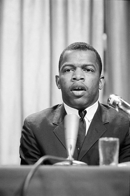
John Lewis (homme politique)
John Robert Lewis, né le 21 février 1940 à Troy (Alabama), est un militant et homme politique américain. Figure du Mouvement afro-américain des droits civiques, il est depuis la fin des années 1980 membre de la Chambre des représentants des États-Unis sous la bannière du Parti démocrate.
 https://upload.wikimedia.org/wikipedia/commons/thumb/b/b7/John_Lewis_1964-04-16.jpg/440px-John_Lewis_1964-04-16.jpg
  https://upload.wikimedia.org/wikipedia/commons/thumb/6/60/John_lewis_official_biopic.jpg/440px-John_lewis_official_biopic.jpg
▻https://fr.wikipedia.org/wiki/John_Lewis_(homme_politique)
-
-

CIA rendition flights from rustic North Carolina called to account by citizens
▻https://www.theguardian.com/us-news/2018/jan/17/cia-rendition-flights-north-carolina-citizens-commissionA Gulfstream jet from a quiet airport south-east of Raleigh flew captives to be tortured around the world. The government failed to act but local people have refused to let the issue die
-

Partis pour Croatan : Artifacts show Lost Colony settlers moved to Hatteras Island, lived with natives, historian says
▻https://pilotonline.com/news/local/history/artifacts-show-lost-colony-settlers-moved-to-hatteras-island-lived/article_5031be6a-e3b5-5531-9401-f63701e278d9.html
▻https://fr.wikipedia.org/wiki/Colonie_de_Roanoke
▻https://en.wikipedia.org/wiki/Roanoke_Colony
▻https://fr.wikipedia.org/wiki/John_White_(colon)
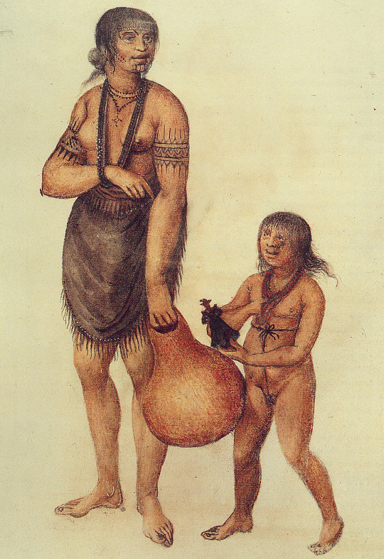
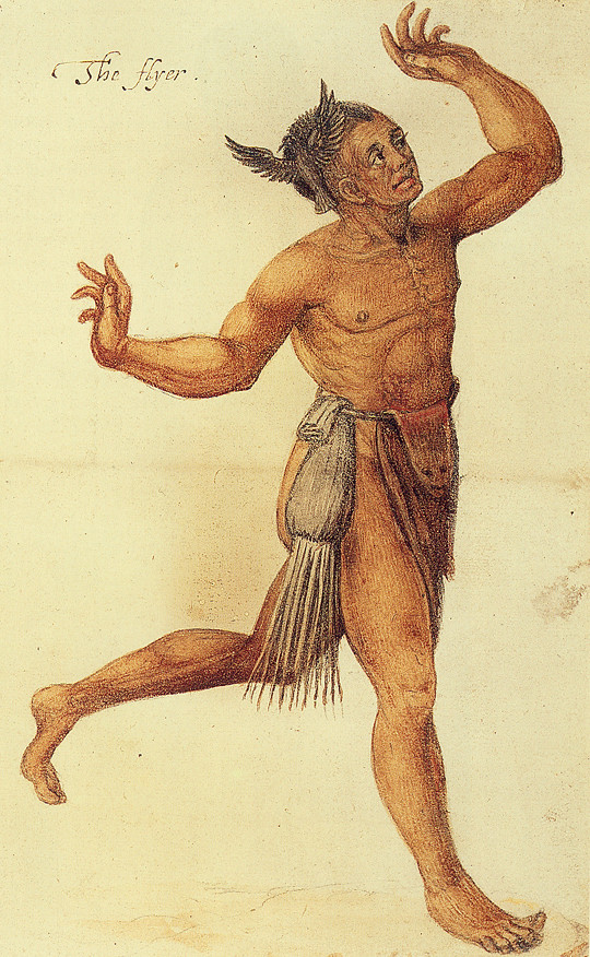
▻https://en.wikipedia.org/wiki/John_White_(colonist_and_artist)Les dessins de John White
▻https://publicdomainreview.org/2012/04/24/painting-the-new-world
In 1585 the Englishman John White, governor of one of the very first North American colonies, made a series of exquisite watercolour sketches of the native Algonkin people alongside whom the settlers would try to live. Benjamin Breen explores the significance of the sketches and their link to the mystery of what became known as the “Lost Colony”. http://farm8.staticflickr.com/7205/7105633531_295fd6d0dd_b.jpg
  http://www.britishmuseum.org/collectionimages/AN00025/AN00025870_001_l.jpg
  http://farm9.staticflickr.com/8152/7105633259_ef1bfe5c07_b.jpg
 À l’école primaire on a appris aux Américains que les premières colonies de Roanoke avaient échoué ; les colons disparurent, ne laissant derrière eux que ce message cryptique : « Partis pour Croatan ». Des récits ultérieurs d’« indiens-aux-yeux-gris » furent classés légendes. Les textes laissent supposer que ce qui se passa véritablement, c’est que les indiens massacrèrent les colons sans défense. Pourtant « Croatan » n’était pas un Eldorado, mais le nom d’une tribu voisine d’indiens amicaux. Apparemment la colonie fut simplement déplacée de la côte vers le Grand Marécage Lugubre et absorbée par cette tribu. Les indiens-aux-yeux-gris étaient réels - ils sont toujours là et s’appellent toujours les Croatans.
Ainsi - la toute première colonie du Nouveau Monde choisit de renoncer à son contrat avec Prospero (Dee/Raleigh/l’Empire) et de suivre Caliban chez l’Homme Sauvage. Ils désertèrent. Ils devinrent « Indiens », « s’indigénèrent » et préférèrent le chaos aux effroyables misères de la servitude, aux ploutocrates et intellectuels de Londres.— Hakim Bey in Taz
#histoire #procrastination #colonisation #amériques -

Why Popular Assemblies Sweeping the Country Are Building Blocks of the Resistance
▻http://www.filmsforaction.org/articles/why-popular-assemblies-sweeping-the-country-are-building-blocks-of-t“One thing that is very clear under the Trump administration is that we do not have the luxury of remaining in our silos and organizing around individual issues,” Manzoor Cheema, a Raleigh, North...
-

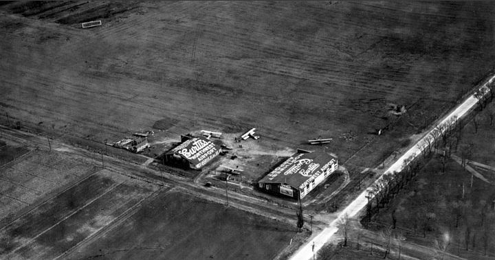
Curtiss-Wright pre-depression era airports – UPDATED | Panethos
▻https://panethos.wordpress.com/2016/10/27/curtiss-wright-pre-depression-era-airportsProvided below is information on those airports which were owned and/or operated by Curtiss Aviation, later Curtiss-Wright Aviation prior to and just after the onset of the Great Depression. These airports were the earliest attempt at privatized airport ownership in the United States, something that remains a rarity here compared to Europe, Asia, and Australia. New information on Raleigh provided below.
-
Extrapolations and Interpolations: Maps that Chart the Unexpected
Everything Sings - Siglio Press
▻http://sigliopress.com/book/everything-sings
Iconoclastic geographer Denis Wood has created an atlas unlike any other. He surveys his small, century-old neighborhood Boylan Heights in Raleigh, North Carolina by first paring away the inessential (scale, orientation, street grids), then by locating the revelatory in the unmapped and unmappable: radio waves permeating the air, the paperboy’s route in space and time, the light cast by street lamps, Halloween pumpkins on porches.
His joyful subversion of the traditional notions of map making forge new ways of seeing not only this particular place, but also the very nature of place itself. In pursuit of a “poetics of cartography,” Wood makes maps in which the experience of place is primary, and the eye is attuned to the invisible, the overlooked, and the seemingly insignificant.
These maps have a traditional rigor, but they also have “fingerprints”—a gamut of subjective arguments about the relationships between social class and cultural rituals, about the neighborhood as “transformer,” about maps’ impermanence and fragility—rejecting the idea that they convey a single, static, objective truth. Together, they accumulate into a multi-layered story about one neighborhood that tells the larger, universal story of how we understand and define the places we call home.
-

Le site du photographe est en carafe.
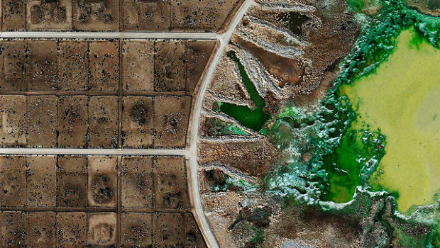
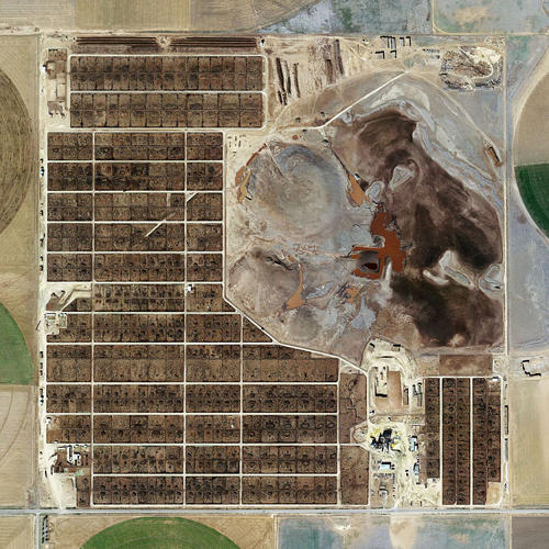
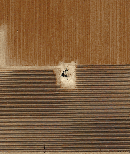
These Horrifying Photos Show A Destroyed American Landscape That Agriculture Giants Don’t Want You To See | Co.Exist | ideas + impact
▻http://www.fastcoexist.com/3016003/these-horrifying-photos-show-a-destroyed-american-landscape-that-agricuHenner first used open source satellite imagery to capture shots of overt and covert U.S. military outposts, which he published as a book in 2010. For the feedlots, he used the same technique, which spared him the legal risk of photographing the feedlots himself in person or in the air.
Not everyone trying to document feedlots has been so lucky. Just last month, National Geographic photographer George Steinmetz was arrested for misdemeanor criminal trespassing when trying to take photos of a Kansas feedlot from a paraglider. A couple of weeks later, journalists and activists filed the first lawsuit against “ag-gag” bills rapidly proliferating across the United States. As model legislation drummed up by the American Legislative Council (ALEC), ag gag bills seek to make entering animal farms and taking photos or recording video illegal. Such laws have passed in Utah, Kansas, Arkansas, Iowa, and Missouri, with more states considering them.
Mishka Henner’s satellite-inspired art will be exhibited in Montreal’s month of photography series, from September through October, and in Raleigh’s Contemporary Art Museum from October through January 2014.
“To me, as somebody in the U.K., looking at something [like] the feedlots I was shocked on a very personal level,” Henner says. “I think what the feedlots represent is a certain logic about how culture and society have evolved. On one level it’s absolutely terrifying, that this is what we’ve become. They’re not just feedlots. They’re how we are.”
Before Henner started looking into satellite imagery of oilfields and military sites, he took photos of post-industrial towns and cities in northern England. It frustrated him, he says, to document environmental decay locally, but miss capturing industrial abuses on a larger scale. With satellite imagery from Google Earth, “I felt suddenly able to deal with really big themes that were important to me,” Henner says. “I’m equipped with the lenses of orbiting satellites and roving Street View cars, suddenly able to see things that I would never be able to see walking around on the ground with the camera.”
-

-

Merci. On a référencé plusieurs fois cette série sur seenthis :) ▻http://seenthis.net/recherche?recherche=Mishka+Henner
-
-
-
-

@unagi non non, laisse-le, ce n’est pas grave, d’ailleurs tout le monde ici ne l’a pas vu.
-

#seenthis_police :)
De toute façon tant que ce n’est pas un lien avec flèche noire devant, on peut rien faire, tu as toutes les protections juridiques
-
-
-
-

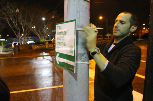
Développer les panneaux de signalisation à faire soi-même - CityLab
▻http://alireailleurs.tumblr.com/post/112591395632La Knight Foundation américaine (une fondation privée de promotion des idées transformatives dans le domaine du journalisme et de l’engagement citoyen) a annoncé qu’elle allait financer une expansion à grande échelle du projet Walk[YourCity] (vidéo), initié par le designer Matt Tomasulo pour promouvoir la marche, rapporte CityLab. Le projet a commencé par l’affichage de panneaux de signalisation dans les rues de Raleigh, en Caroline du Nord en 2012. Ce projet de guérilla urbaine douce consistait à installer des panneaux de signalisation indiquant aux résidents et aux visiteurs la distance de marche pour rejoindre certains lieux de la #ville à pied plutôt qu’en voiture. Devant l’enthousiasme médiatique, la ville en a fait un projet pilote d’éducation citoyenne. Le designer a lancé ensuite une campagne sur (...)
-

-
Most innovative USA metros: 2000-2011 | Panethos
▻http://panethos.wordpress.com/2014/04/05/most-innovative-usa-metros-2000-2011
Below is a list of the twenty most innovative metropolitan areas in the United States, based on the number of patents issued between 2000 and 2011. Most surprising is the absence of the Research Triangle of Raleigh-Durham-Chapel Hill, North Carolina; Denver-Boulder, Colorado; Pittsburgh, Pennsylvania; and the Salt Lake City, Utah urban areas.
#aires_métropolitaine #innovation #états-unis #urban_matters
-

#brevets qui ne sont qu’un indicateur très biaisé d’un mode particulier de valorisation de l’#innovation
-
-
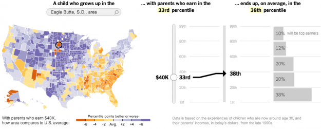
Climbing the income ladder
▻http://flowingdata.com/2013/07/22/climbing-the-income-ladder
Via Nathan Yau de Flowing Data et repris par le NYT. Toujours très intéressant...
In a study conducted by researchers at Harvard and UC Berkeley, data shows spatial variations for the chances of rising out of poverty into higher income brackets. The New York Times reports:
Climbing the income ladder occurs less often in the Southeast and industrial Midwest, the data shows, with the odds notably low in Atlanta, Charlotte, Memphis, Raleigh, Indianapolis, Cincinnati and Columbus. By contrast, some of the highest rates occur in the Northeast, Great Plains and West, including in New York, Boston, Salt Lake City, Pittsburgh, Seattle and large swaths of California and Minnesota.
“Where you grow up matters,” said Nathaniel Hendren, a Harvard economist and one of the study’s authors. “There is tremendous variation across the U.S. in the extent to which kids can rise out of poverty.”
Two things. First, the NYT piece is really nice. Graphics and interactives are typically shown separate from the written story, but NYT has been shifting as of late and I’m sure other publications will follow. (Although, as you can see in the credits, eight people made the graphics, and most places don’t have such resources yet.) The story is all tied together, so you read and interact in a continuous flow.
Second, the Harvard/UC Berkeley research group released the data, so you can have a go yourself.