#emma_willard

  • Emma Willard’s Maps of Time

    In the 21st-century, infographics are everywhere. In the classroom, in the newspaper, in government reports, these concise visual representations of complicated information have changed the way we imagine our world. Susan Schulten explores the pioneering work of Emma Willard (1787–1870), a leading feminist educator whose innovative maps of time laid the groundwork for the charts and graphics of today.

    We live in an age of visual information. Infographics flood the web, driven by accessible platforms that instantly translate information into a variety of graphic forms. News outlets routinely harvest large data sets like the census and election returns into maps and graphs that profile everything from consumer preferences to the political landscape. The current proliferation of visual information mirrors a similar moment in the early nineteenth century, when the advent of new printing techniques coincided with the rapid expansion of education. Schoolrooms from the Atlantic seaboard to the Mississippi frontier made room for the children of farmers as well as merchants, girls as well as boys. Together, these shifts created a robust and highly competitive market for school materials, including illustrated textbooks, school atlases, and even the new genre of wall maps.

    No individual exploited this publishing opportunity more than Emma Willard, one of the century’s most influential educators. From the 1820s through the Civil War, Willard’s history and geography textbooks exposed an entire generation of students to her deeply patriotic narratives, all of which were studded with innovative and creative pictures of information that sought to translate big data into manageable visual forms.

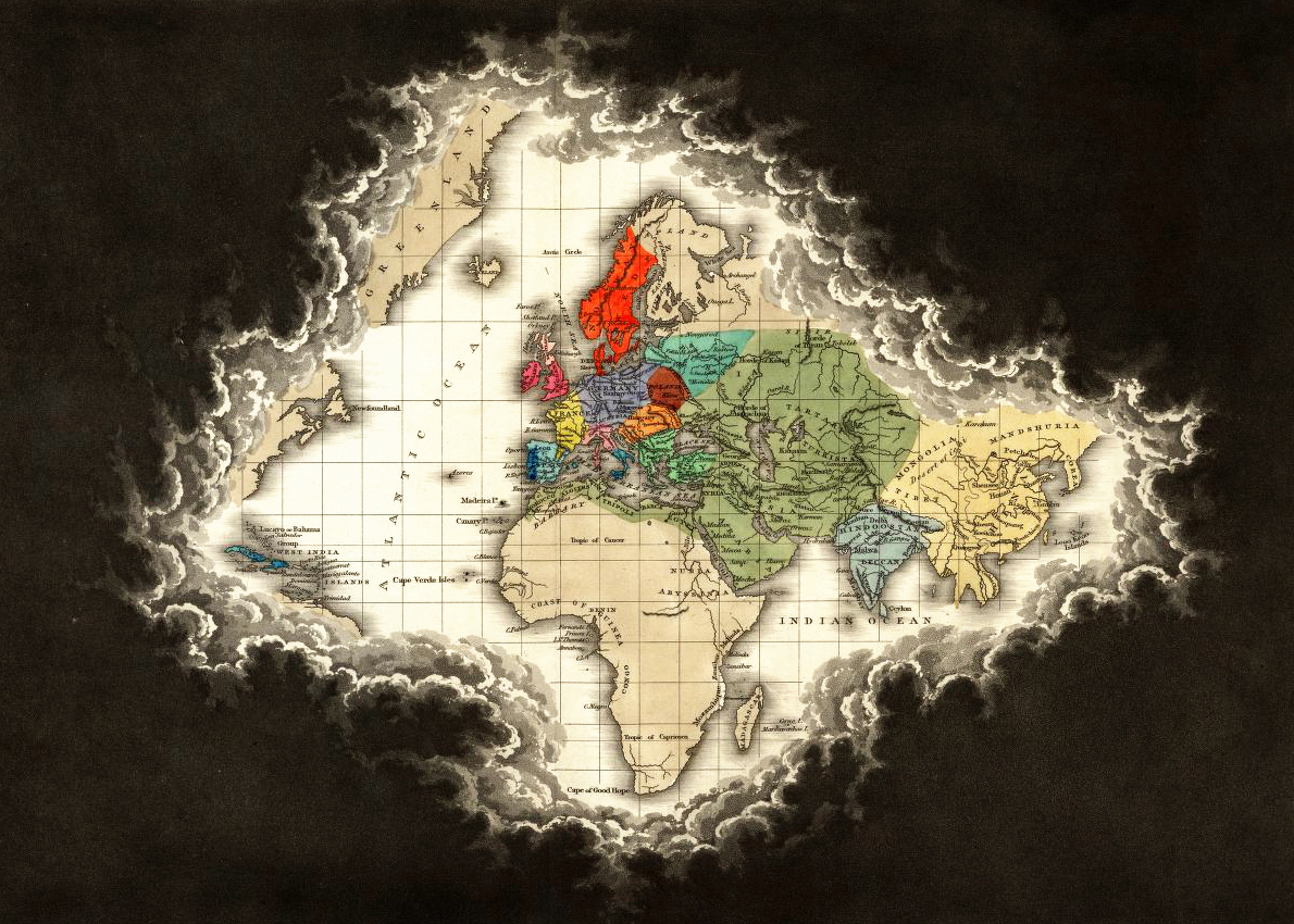
    When Willard began publishing textbooks in the 1820s, she knew the competition was fierce, full of sharp-elbowed authors who routinely accused one another of plagiarizing ideas and text. To build her brand, she designed cutting-edge graphics that would differentiate her work and catch the attention of the young. Take, for instance, her “Perspective Sketch of the Course of Empire” of 1835.

    By the nineteenth century, timelines had become relatively common, an innovation of the eighteenth century designed to feed growing public interest in ancient as well as modern history. First developed by Jacques Barbeu-Dubourg in the 1750s, early timelines generally charted the lives of individuals on a chronological grid, reflecting the Enlightenment assumption that history could be measured against an absolute scale of time, moving inexorably onward from zero. In 1765, Joseph Priestley drew from calendars, chronologies, and geographies to plot the lives of two thousand men between 1200 BC and 1750 AD in his popular Chart of Biography.

    After Priestley, timelines flourished, but they generally lacked any sense of the dimensionality of time, representing the past as a uniform march from left to right. By contrast, Emma Willard sought to invest chronology with a sense of perspective, presenting the biblical Creation as the apex of a triangle that then flowed forward in time and space toward the viewer. Commenting on her visual framework in 1835, Willard noted that individuals experience the past relative to their own lives, for “events apparently diminish when viewed through the vista of departed years.”1 In “Perspective Sketch of the Course of Empire”, she found striking ways to represent this dimensionality of time. The birth of Christ, for example, is marked with a bright light, marking the end of the first third of human history. The discovery of America separated the second (middle) from the third (modern) stage. Each “civilization” is situated not according to its geography, as on a traditional map, but according to its connection and relation to other civilizations. Some of these societies are permeable, flowing into others, while others, such as China, are firmly demarcated to denote their isolation. By studying this map, students were encouraged to see human history as a rise and fall of civilizations — an “ancestry of nations”.

    Moreover, as time flows forward the stream widens, demonstrating that history became more relevant as it unfolds and approaches the student’s own life. Historical time is not uniform but dimensional. On the one hand, this reflected her sense that time itself had accelerated through the advent of steam and rail. Traditional timelines, she found, were only partially capable of representing change in an era of rapid technological progress. Time was not absolute, but relative. On the other hand, Willard’s approach reflected her own deep nationalism, for it asked students to recognize the emergence of the United States as the culmination of human history and progress.

    Willard aggressively marketed her “Perspective Sketch” to American educators, believing it to be a crucial break with other materials on the market. As she confidently expressed to a friend in 1844, “In history I have invented the map”.3 She also advocated for her “map of time” as a teaching device because she strongly believed the visual preceded the verbal — that information presented to students in graphic terms would facilitate memorization, attaching images to the mind through the eyes.

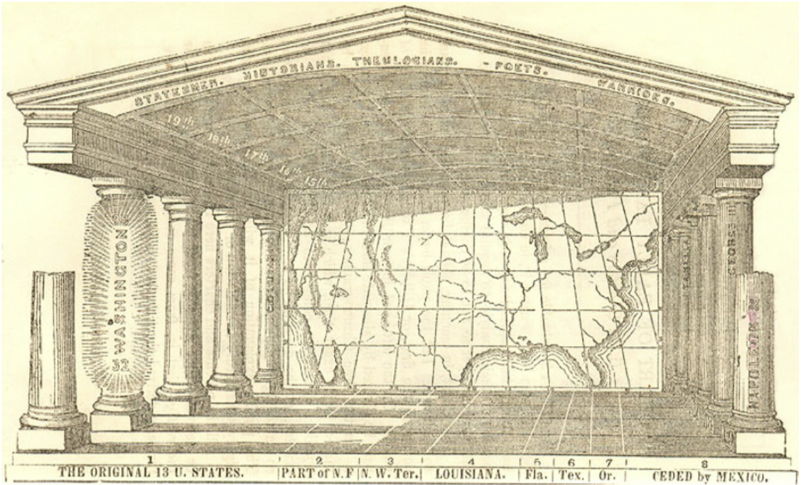
    Willard’s devotion to visual mnemonics shaped much of her work. In the 1840s, she published another elaborate visual device, named the “Temple of Time”. Here, she attempted to integrate chronology with geography: the stream of time she had charted in the previous decade now occupied the floor of the temple, whose architecture she used to magnify perspective through a visual convention. Centuries — represented by pillars printed with the names of the era’s most prominent statesmen, poets, and warriors —diminished in size as they receded in time, turning the viewer’s attention toward recent history, as in the “Course of Empire”. But in the Temple of Time, the one-point perspective also invited students in to inhabit the past, laying out information in a kind of memory palace that would help them form a larger, coherent picture of world history. Readers, in other words, were invited into the palace, so they too could stand at moments in world history.

    The Temple of Time is complicated, and more than a little contrived. Yet Willard reminds readers that traditional cartography relies on the same basic conceit:

    In a map, great countries made up of plains, mountains, seas, and rivers, are represented by what is altogether unlike them; viz., lines, shades, and letters, on a flat piece of paper; but the divisions of the map enable the mind to comprehend, by proportional space and distance, what is the comparative size of each, and how countries are situated with respect to each other. So this picture made on paper, called a Temple of Time, though unlike duration, represents it by proportional space. It is as scientific and intelligible, to represent time by space, as it is to represent space by space.4

    A map, in other words, is an arrangement of symbols into a system of meaning — and we use maps because we understand the language of signs that undergirds them. If the mapping of space was a human invention, she explained, one could also invent a means of mapping time.

    Willard’s creative efforts to “map time” stemmed from personal experience. Born just after the Revolution, she was part of the first generation of American women to be educated outside the home, and she chafed at the way “female education” kept more than a few areas of knowledge off limits. One of the few subjects considered suitable for both boys and girls in that era was geography, yet Willard remembered with frustration the degree to which her textbooks lacked maps. It makes sense, then, that as a young teacher in the 1810s Willard became passionate about having her pupils draw maps — not copying them (a common practice in schools for young women at the time) but rather reproducing them in rough terms from memory to demonstrate a grasp of geographical relationships.

    Willard’s own artistic creativity as a mapmaker was evident from the start. Her first textbook — a geography written with William Woodbridge and published in 1824 — includes a metaphorical map of the Amazon River and its tributaries which illustrates the evolution of the Roman Empire. (One can see in this early effort the prototype for her elaborate “Perspective Sketch” of the 1830s.)

    Willard’s creativity as an educator was equally immense. In 1819 she published a plan to publicly fund the improvement of female education, which met with more than a little resistance. Two years later, she began to implement this vision by founding the Troy Female Seminary in New York—an institution that quickly became a preeminent school for future teachers and one of the most highly regarded schools for women in the country. At Troy, Willard assumed that females were capable of studying the same subjects as their male counterparts and incorporated “masculine studies”, such as science and history, into the curriculum. Her administration of Troy, and her intensive teaching in the decade prior to and after its foundation, convinced her of the multiple failures of contemporary pedagogy and textbooks.

    In 1828, Willard issued the first edition of her History of the United States, or The Republic of America, a textbook so popular it would remain in print until the 1860s. One key element of the book’s success was the atlas that accompanied the text — a series of maps of the eastern US that Willard designed and executed with a former female student. In this series, each map marked particular moments or eras that either led toward or resulted from nationhood, including the landing on Plymouth Rock, the Treaty of Paris, or the late War of 1812 against Britain. Perhaps the most remarkable of these was the “introductory map”, which identified indigenous tribes through a series of geographic migrations, collapsing centuries of movement into a single image. In naming this the “introductory” map, however, Willard situated Native Americans in a prehistorical era antedating the ostensibly more significant events of European settlement. The single image she created was innovative and powerful, but it also rendered the violence of Native displacement as an inevitable prelude that gave way to the real drama of colonialism and the inevitable realization of national independence.

    Willard’s commitment to creative cartography, combined with her nationalism, inspired her to create a simplified American Temple of Time in the late 1840s, which revealed a firm belief in Manifest Destiny: the providential progression from the European discovery of North America in the fifteenth century to a continental empire in the present. The concept of the American Temple was interactive, framing the chronological and geographical outlines of American history to aid memorization. Students were to identify the eight geographical entities that made up the continental United States: the original thirteen colonies, New France, the Northwest Territory, Louisiana, Florida, Texas, Oregon, and the area ceded by Mexico in the 1848 treaty that ended the Mexican–American War. Students were then instructed to locate each state and territory in time by shading its existence as it became part of the country (shading the colonies as they were settled, and the states as they joined the union). If the Temple were drawn large enough, there would also be enough space along the “floor” to identify important battles. The design is complex and unwieldy, but the goal is intriguing: an interactive exercise for students to integrate history and geography in order to understand how the past had—quite literally—taken place.

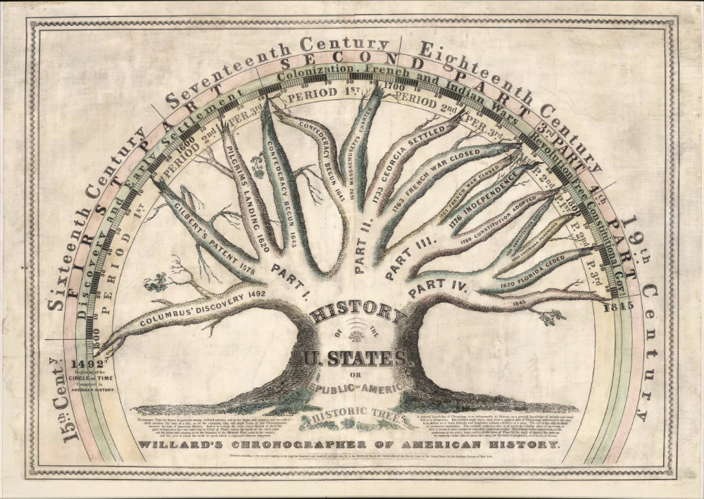
    Willard’s final contribution to visual knowledge was perhaps the most straightforward, a “Tree of Time” that presented American history as a coherent, organic whole. There is, of course, a long tradition of presenting time as a tree (family trees being the most enduring), but Willard used the image not to represent ancestors as trunks and descendants as branches, but — rather oddly — to represent time arcing from left to right, like a timeline. She was so fond of the Tree of Time she used it to introduce all subsequent editions of her popular textbook History of the United States and even issued it on a much larger scale to be hung in classrooms.

    Like the Temple, the Tree presented an encompassing history of the nation that reached back past 1789 to 1492. All of North America’s colonial history merely formed the backstory to the preordained rise of the United States. The tree also strengthened a sense of coherence, organizing the chaotic past into a series of branches that spelled out the national meaning of the past. Above all, the Tree of Time conveyed to students a sense that history moved in a meaningful direction. Imperialism, dispossession, and violence was translated, in Willard’s representation, into a peaceful and unified picture of American progress.

    Ironically, it was the cataclysms of the Civil War that challenged Willard’s harmonious picture of history in the Tree of Time. In the 1844 edition of the Tree, President Harrison’s death marched the last branch of history. Twenty years later, Willard added a new branch marking the end of the US war against Mexico and the subsequent Compromise of 1850, seismic events which both raised and temporarily settled the sectional divisions over slavery. Even though the Civil War was well underway by the time she issued her last edition of tree, she marked the last branch as “1860”, with no mention of the bloody conflict that had engulfed the entire nation. Her accompanying narrative in Republic of America brought American history to the brink of war, but no further. Willard had come up against history itself.

    https://publicdomainreview.org/essay/emma-willard-maps-of-time

    #Emma_Willard #cartographie_historique #cartographie #peuples_autochtones #infographie #femme_géographe #femme_cartographe

    voir aussi :
    https://seenthis.net/messages/917835

    –-

    ajouté au fil de discussion sur les femmes géographes :
    https://seenthis.net/messages/662774

    ping @visionscarto @reka

  • Clouds of Unknowing : Edward Quin’s Historical Atlas (1830)

    “Now when I was a little chap I had a passion for maps”, says the seafaring raconteur #Charles_Marlow in Joseph Conrad’s Heart of Darkness (1899) (https://www.gutenberg.org/files/219/219-h/219-h.htm). “At that time there were many blank spaces on the earth, and when I saw one that looked particularly inviting on a map (but they all look that) I would put my finger on it and say, ’When I grow up I will go there.’” Of course, these “blank spaces” were anything but. The no-man’s-lands that colonial explorers like #Marlow found most inviting (the Congo River basin, #Tasmania, the #Andaman_Islands) were, in fact, richly populated, and faced devastating consequences in the name of imperial expansion.

    In the same troublesome vein as Marlow, Edward Quin’s Historical Atlas painted cartographic knowledge as a candle coruscating against the void of ignorance, represented in his unique vision by a broiling mass of black cloud. Each map represents the bounds of geographical learning at a particular point in history, from a specific civilizational perspective, beginning with Eden, circa “B.C. 2348”. In the next map titled “B.C. 1491. The Exodus of the Israelites”, Armenia, Assyria, Arabia, Aram, and Egypt form an island of light, pushing back the black clouds of unknowing. As history progresses — through various Roman dynasties, the reign of Charlemagne, and the Crusades — the foul weather retreats further. In the map titled “A.D. 1498. The Discovery of America”, the transatlantic exploits of the so-called Age of Discovery force Quin to employ a shift in scale — the luminescence of his globe now extends to include Africa and most of Asia, but North America hides behind cumulus clouds, with its “unnamed” eastern shores peeking out from beneath a storm of oblivion. In the Atlas’ last map, we find a world without darkness, not a trace of cloud. Instead, unexplored territories stretch out in the pale brown of vellum parchment, demarcating “barbarous and uncivilized countries”, as if the hinterlands of Africa and Canada are awaiting colonial inscription.

    Not much is known about Edward Quin, the Oxford graduate, London barrister, and amateur cartographer whose Atlas was published two years after his death at the age of thirty-four. We learn, thanks to Walter Goffart’s research into historical atlases, that Quin’s images were more popular than his words. The well-regarded cartographer William Hughes rescaled the maps for a new edition in 1846, discarding their artist’s accompanying text. The Atlas’ enduring technical advancement, which influenced subsequent cartographers, can be found in its ingenious use of negative space. Emma Willard’s Atlas to Accompany a System of Universal History, for instance, features cloudy borders that seem very much indebted to Quin.

    Looking back from a contemporary vantage, the Historical Atlas remains memorable for what is not shown. Quin’s cartography inadvertently visualizes the ideology of empire: a geographic chauvinism that had little respect for the knowledge of those beyond imperial borders. And aside from depicting the reach of Kublai Khan, his focus remains narrowly European and Judeo-Christian. While Quin strives for accuracy, he admits to programmatic omission. “The colours we have used being generally meant to point out and distinguish one state or empire from another. . . were obviously inapplicable to deserts peopled by tribes having no settled form of government, or political existence, or known territorial limits”. Instead of representing these groups, Quin, like his clouds, has erased them from view.

    https://publicdomainreview.org/collection/edward-quin-historical-atlas
    #cartographie_historique #cartographie #connu #inconnu #géographie_du_vide #vide #histoire #Tasmanie #fleuve_Congo #colonisation #colonialisme #Edward_Quin #atlas

    ping @reka @visionscarto

    via @isskein

  • Emma Willard, America’s First Female Mapmaker
    https://www.theparisreview.org/blog/2018/06/18/americas-first-female-mapmaker

    A recent item for sale in the rare-book trade caught my eye. Boston Rare Maps had a series of twelve maps created by America’s first female mapmaker, Emma Willard. They were to accompany a textbook she had written, first issued in 1828. The maps for sale were from the second edition.

    Willard is well-known to historians of the early republic as a pioneering educator, the founder of what is now called the Emma Willard School, in Troy, New York. But she was also a versatile writer, publisher and, yes, mapmaker. She used every tool available to teach young readers (and especially young women) how to see history in creative new ways. If the available textbooks were tedious (and they were), she would write better ones. If they lacked illustrations, she would provide them. If maps would help, so be it: she would fill in that gap as well. She worked with engravers and printers to get it done. She was finding her way forward in a male-dominated world, with no map to guide her. So she made one herself.

    #cartographie #visualisation #femmes #historicisation #Emma_Willard

    • Coming of age? Reflections on the centenary of women’s admission to the Royal Geographical Society

      Women’s admission to the Royal Geographical Society was at least a two-staged affair, with a cohort of 22 women being admitted in 1892–93 before open access to women from 1913. However, whilst official membership was defined by these historic line-in-the-sand ‘boundary’ moments, some aspects of women’s participation within the Society were enacted in a permeable ‘frontier zone’. Both prior to, and after, fully accessing Fellowship in 1913, women were active producers of geographical knowledge – travelling, researching, writing, and teaching. Given these blurred thresholds of participation and recognition, and the complex social politics of majority/minority views on women’s access to full membership, marking and celebrating the centenary of women’s admission to the Society is riddled with ambiguities. What is unambiguous, however, is that the centenary presents a long-overdue opportunity to celebrate over a hundred years of women’s geographical work. It also offers a moment to pause and reflect on the status of women within the discipline today.

      http://onlinelibrary.wiley.com/doi/10.1111/geoj.12051/full

    • Les premières géographes universitaires en France : enquête sur les débuts d’une féminisation disciplinaire (1913-1928)

      Dans le premier quart du XXe siècle, la géographie universitaire française connaît une féminisation lente et difficile, mais réelle, accélérée par la Grande Guerre. C’est le temps des pionnières, autant dans les revues disciplinaires que dans l’institution académique. Cependant, si plusieurs noms sont déjà connus parmi ces premières géographes féminines, il s’agit ici de systématiser l’étude, de quantifier et d’expliquer le phénomène, et d’évaluer la réalité de cette présence dans un champ scientifique jeune mais considéré comme particulièrement rétif aux femmes, en particulier dans le travail de terrain. A ce titre, une large place est accordée aux marges de la discipline, aux outsiders masculins et féminins et à la comparaison internationale, pour donner une vision plus équilibrée d’une évolution jusqu’ici sous-estimée.

      http://journals.openedition.org/cybergeo/27138

    • Early Women Geography Educators, 1783-1932

      This article is a study of early women geography educators between the years 1783 and 1932. Many women were working in the field at that time, but with varying degrees of activity. Twenty-six were especially active in geography contributing significantly to the growth of geography in universities, colleges, and public schools. Some of the women wrote geography textbooks in the pre-professional geography period before 1875. As such, they would be considered geographers, but it was not until the 1890s that women became involved in professional geography. The professional activities of seven women are highlighted as representative of women who were especially active in the discipline.

      http://www.tandfonline.com/doi/abs/10.1080/00221349908978944

    • Quelques (très rares) femmes dans ce bouquin :
      Dictionnaire biographique de géographes français du XXe siècle, aujourd’hui disparus

      Le XXème siècle a vu se former puis s’étendre la communauté des géographes, en même temps que la discipline s’est développée et enrichie, depuis le rôle déterminant du Service Géographique de l’Armée dans les domaines de la topographie, de la géodésie et de la cartographie, et le rôle fondateur des excursions interuniversitaires annuelles permettant aux étudiants d’accompagner leurs professeurs et d’apprendre la géographie sur le terrain. Le XXème siècle a vu aussi naître les principales organisations et associations de géographes français ainsi que l’Union Géographique Internationale en 1922. À la suite de la présentation de ces structures, les notices biographiques de plus de 400 géographes français sont complétées par une vaste collection de photographies prises au long du siècle - de 1897 au début des années 2000.

      http://geoprodig.cnrs.fr/items/show/42528

    • Renée Rochefort (1924-2012)

      Repères bibliographiques (non exhaustifs)
      1958 « Un dossier sur le temps présent : les bas-fonds de Palerme, d’après l’enquête de Danilo Dolci » [note critique], Annales É.S.C., 13-2, pp. 349-358.
      1959 « Misère paysanne et troubles sociaux. Un pays du Latifondo sicilien : Corleone », Annales. É.S.C., 1959, Volume 14, Numéro 3, pp. 441-460.
      1961 Le Travail en Sicile. Étude de géographie sociale, Paris, PUF, 1961.
      Les bouches de Kotor. Étude de géographie régionale, essai sur les espaces d’une région, Lyon, Université de Lyon, Faculté des Lettres.
      1963 « Géographie sociale et sciences humaines », Bulletin de l’Association de géographes français, 1963, XL, n° 314, pp. 18-32.
      « Sardes et Siciliens dans les grands ensembles des Charbonnages de Lorraine », Annales de Géographie, 1963, LXXII, n° 391, pp. 272-302.
      1970 « Grands ensembles et mutations des banlieues lyonnaises », Revue de géographie de Lyon, 1970, XLV, n° 2, pp. 201-214.
      1972 « Géographie sociale et environnement », dans La pensée géographique française. Mélanges offerts au Professeur A. Meynier, Saint-Brieuc, Presses universitaires de Bretagne, 1972, p. 395-405.
      1977 « Les enfants et adolescents dans l’agglomération lyonnaise en 1976 : disparités et ségrégations », Revue de géographie de Lyon, 1977, LII, n° 4, pp. 319-337.
      1983 « Réflexions liminaires sur la géographie sociale », dans Noin, D., dir., Géographie sociale, actes du colloque de Lyon, 14-16 octobre 1982, dactylographié, 1983, p. 11-14.
      1984 « Pourquoi la géographie sociale ? », dans Coll., De la géographie urbaine à la géographie sociale. Sens et non-sens de l’espace, Paris, 1984, p. 13-17.
      1984 « Les classes sociales, l’État et les cultures en géographie sociale », Revue de géographie de Lyon, 1984, LIX, p. 157-172.


      http://www.esprit-critique.net/2017/01/renee-rochefort-ossature-du-power-point.html

      Elle travaille notamment sur les #banlieue et les #grands_ensembles :
      http://www.persee.fr/doc/geo_0003-4010_1963_num_72_391_16412

      http://www.persee.fr/doc/geoca_0035-113x_1977_num_52_4_6141

      #géographie_sociale

    • Quelques grandes voyageuses, pas académiques:
      Alexandra David-Néel

      Louise Eugénie Alexandrine Marie David, plus connue sous le nom d’Alexandra David-NéelNote 1, née le 24 octobre 1868 à Saint-Mandé, morte à près de 101 ans le 8 septembre 1969 à Digne-les-Bains, est une orientaliste, tibétologue, chanteuse d’opéra et féministe, journaliste et anarchiste, écrivaine et exploratrice, franc-maçonne et bouddhiste de nationalités française et belge.

      Elle fut, en 1924, la première femme d’origine européenne à séjourner à Lhassa au Tibet, exploit dont les journaux se firent l’écho un an plus tard1 et qui contribua fortement à sa renommée, en plus de ses qualités personnelles et de son érudition.

      https://fr.wikipedia.org/wiki/Alexandra_David-N%C3%A9el

    • Et cet article signalé par @odilon et @reka
      Femmes en géographie au temps des changements

      Longtemps minoritaires, mais absolument pas absentes du champ de la géographie universitaire française depuis le début du xxe siècle, les femmes ont occupé une place croissante dans la discipline après 1945. Cette féminisation s’est accentuée à partir des années 1960, selon des modalités que la présente étude s’efforce de mesurer pour la période 1960-1990, époque de profondes modifications académiques, morphologiques et scientifiques dans la communauté disciplinaire. On montrera en particulier que, pour être solidement ancrée dans des domaines parfois inattendus, ce phénomène s’appuie alors sur des réseaux féminins constitués et un féminisme relativement précoce et affirmé, quoique marginal.

      https://www.cairn.info/revue-espace-geographique-2017-3-p-236.htm

    • Aventurière, écrivaine et même cantatrice : découvrez la vie trépidante d’#Alexandra_David_Néel

      Chaque semaine, dans « Chacun sa route », Elodie Font dresse le portrait d’une #exploratrice de génie. Alexandra David-Néel est sans doute la plus connue des exploratrices françaises, une femme au caractère assez dur pour une vie de rencontres et d’écriture.

      https://www.franceinter.fr/culture/aventuriere-ecrivaine-et-meme-cantatrice-decouvrez-la-vie-trepidante-d-a
      #exploration

    • L’altra mappa

      Perché le donne non fanno parte, al pari dei loro colleghi maschi, della società di esploratori, viaggiatori e geografi? Eppure non sono poche le donne esploratrici, viaggiatrici e geografe che in età moderna e contemporanea hanno dato il loro contributo alla rappresentazione del mondo. Alcune sono più note: Lady Montagu in viaggio a Costantinopoli nella prima metà del Settecento; Léonie d’Aunet, compagna di Victor Hugo, in viaggio verso Polo Nord e Lapponia; Dora d’Istria, colta europeista ante litteram. E ancora la tedesca Ida Pfeiffer, viaggiatrice “patentata” da A. Von Humboldt; Alexandra David-Néel, prima donna a entrare nel cerchio sacro della città di Lhasa. Ma assai vasta sarebbe la galleria delle figure inedite. Dopo un’ampia introduzione teorica, la prima parte del volume si snoda fra viaggi che sembrano veri e sono inventati, e viaggi reali che fanno fatica a essere riconosciuti come tali; la seconda parte riguarda alcuni casi di viaggiatrici-esploratrici del XIX e XX secolo: insieme ai nomi, ai volti, ai viaggi, Luisa Rossi ci restituisce una geografia diversa, un’altra mappa.

      https://diabasis.it/prodotto/laltra-mappa

    • Lady Travellers

      Tra la fine dell’800 e i primi del ‘900, una vera rivoluzione travolge il vecchio e il nuovo mondo. Le donne iniziano a viaggiare sole, sfidando le convenzioni dell’epoca. Annotano, fotografano, disegnano e raccontano la loro versione della realtà. Ma esiste veramente un modo di viaggiare tutto femminile?


      Lady Travellers, donne viaggiatrici, è una serie storico-documentaristica che ricostruisce 6 imprese straordinarie condotte a cavallo tra ‘800 e ‘900, raccontate dal punto di vista femminile.

      Ogni episodio è dedicato a una donna diversa e alla sua incredibile impresa, e ogni impresa è dedicata a un paese diverso. Le vicende umane delle protagoniste sono narrate in prima persona, attraverso la tecnica del teatro delle ombre, impastati a repertori fotografici e video d’epoca.

      Le donne viaggiatrici sono:

      #Alexandra_David_Neel, francese, la prima donna a raggiungere Lhasa;
      #Giuseppina_Croci, una giovane donna italiana di 27 anni che alla fine dell’800 va a lavorare in una filanda in Cina;
      #Mary_Kingsley, inglese, trascorse alcuni mesi in Africa per studiare le tribù cannibali
      #Isabella_Bird, inglese, la prima donna ammessa alla Royal Geographical Society
      #Carmen_De_Burgos, prima donna spagnola inviata di guerra
      #Marga_D’Andurain, avventuriera basca francese, spia e contessa, voleva essere la prima donna a raggiungere La Mecca.
      #Nellie_Bly, giornalista statunitense, è stata la prima donna a fare il giro del mondo in solitaria
      #Aurora_Bertrana, spagnola, viaggiò dalla Polinesia al Marocco, pioniera della narrativa di viaggio e punto di riferimento per molte donne.
      #Ella_Maillart, viaggiò con la barca vela per tutto il mediterraneo. All’età di 23 anni abbandona le regate e comincia a viaggiare per l’Europa e per l’Unione Sovietica.
      #Gertrude_Bell, scrittrice, diplomatica, archeologa: fu la prima fautrice di un rapporto con i popoli del Medio Oriente orientato al rispetto e a una progressiva indipendenza politica ed economica
      #Freya_Madaleine_Stark, è stata la prima occidentale a raggiungere la leggendaria Valle degli Assasini, in Iran, alla ricerca della fortezza di Alamut
      #Eva_Mameli_Calvino, madre dello scrittore Italo Calvino e docente di botanica, si trasferisce a Cuba e qui studia piante mai viste prima. Partecipa alla resistenza ed è fucilata.

      http://www.raiscuola.rai.it/programma.aspx?ID=217

    • #Ida_Laura_Pfeiffer

      Ida Laura Reyer, è un’austriaca e di famiglia benestante, nata a Vienna il 4 ottobre 1797: è la quinta di sei fratelli, tutti maschi, figli di un agiato mercante di tessuti che muore prematuramente quando lei ha appena nove anni.

      Sin da piccola non segue il modello dell’eterno femminino e veste come i fratelli, forgiata anche dalla rigida educazione del padre Alois, improntata a coraggio, determinazione, sobrietà… È un’accanita lettrice di libri di viaggi e di avventura e tutto ciò che le permette di evadere dal “quotidiano” l’attira irrefrenabilmente.

      Gli amici di famiglia raccontano che amava correre fuori casa per veder passare, con lo sguardo sognante, le diligenze che lasciavano la città.

      Si innamora del suo giovane precettore, che le trasmette la passione per la geografia, ma la madre si oppone al loro amore e, costretta dalle difficoltà economiche in cui versa la famiglia, a ventidue anni accetta di sposare l’avvocato Max Anton Pfeiffer, molto più anziano di lei: è un matrimonio triste e senza amore, vissuto in ristrettezze economiche per il fallimento del marito e con il cuore gonfio di malinconia. Non resta con le mani in mano e per tirare avanti dà lezioni di piano e fa la segretaria.

      Scrive di quegli anni: «Solo il cielo sa cosa ho sofferto. Vi sono stati giorni in cui vi era solo pane secco per la cena dei miei figli».

      Vede il mare per la prima volta nel 1836, quando si reca a Trieste con un figlio, e in quel momento scatta la scintilla.

      Nel 1842, diventata vedova e con i figli già grandi, all’età di quarantasette anni guarda oltre lo steccato della mediocrità e dell’ovvio. Spinta dal desiderio incontrollato della conoscenza e dotata di grandissima immaginazione e coraggio verso la scoperta dell’ignoto, part per 9 mesi e, e da sola: discende il Danubio, si addentra in Turchia e in Libano, visita la Palestina, arriva in Egitto, sosta a Malta e risale l’Italia fino a Trieste.

      A casa studia le lingue del Nord e poi riparte per altri sei mesi, alla volta di Scandinavia e Islanda.

      Diviene navigatrice, esploratrice a bordo di mezzi di fortuna, gira il mondo portando a casa testimonianze di alternative esistenze dove non il denaro o il ceto sociale, ma lo stato di natura e la collocazione dell’umanità al suo interno erano motivo di studio, come forma di miglioramento della propria esperienza da trasmettere agli altri.

      Sono viaggi spartani, fatti in economia, spesso avvalendosi di passaggi gratuiti: a volte indossa abiti maschili per potersi mescolare alle gente e osservare più liberamente il comportamento delle popolazioni incontrate nel suo peregrinare tra i continenti.

      Percorrerà 140.000 miglia marine e 20.000 miglia inglesi via terra.

      Il suo primo viaggio intorno al mondo dura due anni e sette mesi. Si imbarca da Amburgo per raggiungere il Brasile e poi il Cile. Da qui poi attraversa l’Oceano Pacifico approdando a Tahiti fino ad arrivare all’isola di Ceylon. Risale attraverso l’India fino al Mar Nero e alla Grecia sbarcando a Trieste e ritornando a Vienna.

      Mentre si trova in Oriente scrive sul suo diario: «In quella mischia ero davvero sola e confidavo solo in Dio e nelle mie forze. Nessuna anima gentile mi si avvicinò».

      Il secondo giro del mondo va in senso opposto, da Ovest verso Est, e dura quattro anni: da Londra giunge a Città del Capo per poi esplorare il Borneo e avere contatti ravvicinati con i “tagliatori di teste” del Dayak, attraversa l’Oceano Pacifico in senso inverso, arriva in California e inizia a percorrere tutti gli Stati americani.

      È la prima donna bianca che nel 1852 si reca nella giungla di Sumatra 1852) abitata dai batak, ritenuti cannibali. In quell’occasione riesce a salvarsi dicendo ai cannibali: «La mia testa è troppo vecchia e dura per essere mangiata», e il saggio capo tribù inizia a ridere e la lascia libera.

      Non si risparmia nulla in fatto di pericoli, in un mondo non ancora sotto la lente d’ingrandimento di un satellite.

      E poi il Madagascar, Réunion e Mauritius, con la malaria che la tiene sotto assedio e la porterà a quell’ultimo viaggio da cui non c’è ritorno.

      Dei suoi viaggi scrive appunti a matita, con una calligrafia piccola e minuta, raccontando i suoi sette viaggi in tredici volumi di diari che diventano bestseller e vengono tradotti in sette lingue.

      Finalmente, viene ammessa a far parte delle Società geografiche di Berlino e Parigi, ma non di quella inglese, ostinatamente negata alle donne.

      I musei di Vienna custodiscono, ancora oggi, piante, insetti e farfalle che lei raccoglie ovunque e porta in patria.

      In una bellissima e significativa foto del 1856 Ida è seduta su un divano con un vestito dell’epoca, con il capo coperto da una cuffietta bianca di pizzo, il braccio destro su un grosso libro, accanto a lei un enorme mappamondo, i suoi occhi non guardano l’obiettivo ma altrove, lontano lontano.

      Muore il 27 ottobre 1858. Il cimitero centrale di Vienna ne conserva le spoglie.

      Nel 2018 l’Università della stessa Vienna le intitola una cattedra con borsa di studio, ma nelle vie della sua città natale manca ancora il suo nome. È Monaco di Baviera a dedicarle la sua prima strada.

      https://vitaminevaganti.com/2021/09/18/ida-laura-pfeiffer