• Map Worlds. A History of Women in Cartography

    Map Worlds plots a journey of discovery through the world of women map-makers from the golden age of cartography in the sixteenth-century Low Countries to tactile maps in contemporary Brazil. Author Will C. van den Hoonaard examines the history of women in the profession, sets out the situation of women in technical fields and cartography-related organizations, and outlines the challenges they face in their careers. Map Worlds explores women as colourists in early times, describes the major houses of cartographic production, and delves into the economic function of intermarriages among cartographic houses and families. It relates how in later centuries, working from the margins, women produced maps to record painful tribal memories or sought to remedy social injustices. Much later, one woman so changed the way we think about continents that the shift has been likened to the Copernican revolution. Other women created order and wonder about the lunar landscape, and still others turned the art and science of making maps inside out, exposing the hidden, unconscious, and subliminal “text” of maps. Shared by all these map-makers are themes of social justice and making maps work for the betterment of humanity.


    https://www.wlupress.wlu.ca/Books/M/Map-Worlds
    #cartographie #femmes #historicisation #femmes_cartographes #livre
    ping @reka

  • Who Maps the World ?

    Too often, men. And money. But a team of OpenStreetMap users is working to draw new cartographic lines, making maps that more accurately—and equitably—reflect our space.

    “For most of human history, maps have been very exclusive,” said Marie Price, the first woman president of the American Geographical Society, appointed 165 years into its 167-year history. “Only a few people got to make maps, and they were carefully guarded, and they were not participatory.” That’s slowly changing, she said, thanks to democratizing projects like OpenStreetMap (OSM).

    OSM is the self-proclaimed Wikipedia of maps: It’s a free and open-source sketch of the globe, created by a volunteer pool that essentially crowd-sources the map, tracing parts of the world that haven’t yet been logged. Armed with satellite images, GPS coordinates, local community insights and map “tasks,” volunteer cartographers identify roads, paths, and buildings in remote areas and their own backyards. Then, experienced editors verify each element. Chances are, you use an OSM-sourced map every day without realizing it: Foursquare, Craigslist, Pinterest, Etsy, and Uber all use it in their direction services.

    When commercial companies like Google decide to map the not-yet-mapped, they use “The Starbucks Test,” as OSMers like to call it. If you’re within a certain radius of a chain coffee shop, Google will invest in maps to make it easy to find. Everywhere else, especially in the developing world, other virtual cartographers have to fill in the gaps.

    But despite OSM’s democratic aims, and despite the long (albeit mostly hidden) history of lady cartographers, the OSM volunteer community is still composed overwhelmingly of men. A comprehensive statistical breakdown of gender equity in the OSM space has not yet been conducted, but Rachel Levine, a GIS operations and training coordinator with the American Red Cross, said experts estimate that only 2 to 5 percent of OSMers are women. The professional field of cartography is also male-dominated, as is the smaller subset of GIS professionals. While it would follow that the numbers of mappers of color and LGBTQ and gender-nonconforming mappers are similarly small, those statistics have gone largely unexamined.

    There is one arena where women’s OSM involvement, specifically, is growing, however: within organizations like Humanitarian OpenStreetMap Team (HOT) and Missing Maps, which work to develop parts of the map most needed for humanitarian relief, or during natural disasters.
    When women decide what shows up on the map

    HOT has worked on high-profile projects like the “crisis mapping” of Puerto Rico in the wake of Hurricane Maria, and on humble but important ones, like helping one Zimbabwe community get on their city’s trash pickup list by highlighting piles of trash that littered the ground. Missing Maps is an umbrella group that aids it, made up of a coalition of NGOs, health organizations like the Red Cross, and data partners. It works to increase the number of volunteers contributing to humanitarian mapping projects by educating new mappers, and organizing thousands of map-a-thons a year.

    In HOT’s most recent gender equity study, it found that 28 percent of remote mappers for its projects were women. And in micro-grant-funded field projects, when organizations worked directly with people from the communities they were mapping, women participants made up 48 percent.

    That number dwarfs the percentage in the rest of the field, but parity (or majority) is still the ultimate aim. So in honor of International Women’s Day, Missing Maps organized about 20 feminist map-a-thons across the country, including one at the American Red Cross headquarters in downtown Washington, D.C., led by Levine along with a team of women volunteers. Price spoke as the guest of honor, and around 75 people attended: members of George Washington University’s Humanitarian Mapping Society, cartography enthusiasts, Red Cross volunteers and employees. There were women and men; new mappers and old.

    I turned up with my computer and not one cartographical clue.

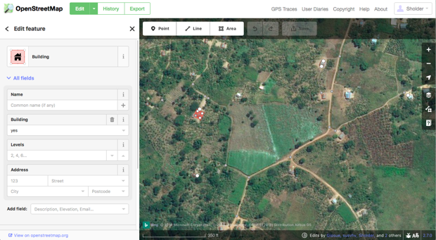
    The project we embarked on together was commissioned by the Tanzanian Development Trust, which runs a safe house for girls in Tanzania facing the threat of genital mutilation. Its workers pick up and safely shelter girls from neighboring villages who fear they’ll be cut. When a girl calls for help, outreach workers need to know where to go pick them up, but they’re stuck in a Google Maps dead zone. Using OSM, volunteers from all over the world—including girls on the ground in Tanzania—are filling in the blanks.

    When it comes to increasing access to health services, safety, and education—things women in many developing countries disproportionately lack—equitable cartographic representation matters. It’s the people who make the map who shape what shows up. On OMS, buildings aren’t just identified as buildings; they’re “tagged” with specifics according to mappers’ and editors’ preferences. “If two to five percent of our mappers are women, that means only a subset of that get[s] to decide what tags are important, and what tags get our attention,” said Levine.

    Sports arenas? Lots of those. Strip clubs? Cities contain multitudes. Bars? More than one could possibly comprehend.

    Meanwhile, childcare centers, health clinics, abortion clinics, and specialty clinics that deal with women’s health are vastly underrepresented. In 2011, the OSM community rejected an appeal to add the “childcare” tag at all. It was finally approved in 2013, and in the time since, it’s been used more than 12,000 times.

    Doctors have been tagged more than 80,000 times, while healthcare facilities that specialize in abortion have been tagged only 10; gynecology, near 1,500; midwife, 233, fertility clinics, none. Only one building has been tagged as a domestic violence facility, and 15 as a gender-based violence facility. That’s not because these facilities don’t exist—it’s because the men mapping them don’t know they do, or don’t care enough to notice.
    In 2011, the OSM community rejected an appeal to add the “childcare” tag at all. It was finally approved in 2013, and in the time since, it’s been used more than 12,000 times.

    So much of the importance of mapping is about navigating the world safely. For women, especially women in less developed countries, that safety is harder to secure. “If we tag something as a public toilet, does that mean it has facilities for women? Does it mean the facilities are safe?” asked Levine. “When we’re tagging specifically, ‘This is a female toilet,’ that means somebody has gone in and said, ‘This is accessible to me.’ When women aren’t doing the tagging, we just get the toilet tag.”

    “Women’s geography,” Price tells her students, is made up of more than bridges and tunnels. It’s shaped by asking things like: Where on the map do you feel safe? How would you walk from A to B in the city without having to look over your shoulder? It’s hard to map these intangibles—but not impossible.

    “Women [already] share that information or intuitively pick it up watching other women,” Price said. “Those kinds of things could be mapped. Maybe not in an OSM environment, but that happens when cartography goes into many different hands and people think of different ways of how we know space, classify space, and value space.”

    That’s why Levine believes that the emphasis on recruiting women mapmakers, especially for field projects like the Tanzanian one, is above all else a practical one. “Women are the ones who know the health facilities; they know what’s safe and unsafe; they know where their kids go to play; they know where to buy groceries,” she said. “And we have found that by going to them directly, we get better data, and we get that data faster.”

    Recording more women-centric spaces doesn’t account for the many LGBTQ or non-binary spaces that go unmapped, a gap the International Women’s Day event didn’t overtly address. But elsewhere on the internet, projects like “Queering the Map” seek to identify queer spaces across the globe, preserving memories of LGBTQ awakenings, love stories, and acts of resistance. Instead of women’s health centers, the Queered Map opens a space to tag gay bars, or park benches where two women once fell in love, or the street in Oakland someone decided to change their “pronouns to they/them.” It’s a more subjective way to label space, and less institutionalized than the global OSM network. But that’s sort of the point.
    Service through cartography

    The concentration of women mappers in humanitarian projects is partly due to the framing of cartography as a service-driven skill, Levine said, rather than a technical one. That perception reflects the broader dynamics that alienate women from STEM fields—the idea that women should work as nurturers, not coders—but many women at the map-a-thon agreed that it was a drive to volunteer that first drew them to OSM.

    Maiya Kondratieff and Grace Poillucci, freshmen at George Washington University, are roommates. Both of them unexpectedly fell into digital mapping this year after seeing GW’s Humanitarian Mapping Society advertised at the university club fair. They were joined at the Missing Maps event by fellow society member Ethan Casserino, a third-year at GW.

    “It wasn’t presented as a tech-y thing; more like service work,” said Kondratieff. “And our e-board is mostly even” in terms of gender representation, she added. One of those older leaders of the group spent much of the night hurrying around, dishing out pizza and handing out stickers. Later, she stopped, leaned over Kondratieff’s shoulder, and helped her solve a bug in her map.

    Rhys, a cartography professional who asked not to be identified by last name, graduated from GW in 2016 and majored in geography. A lot of her women peers, she said, found their way into cartography based on an interest in art or graphic design. As things become more technology-heavy, she’s observed a large male influx. “It’s daunting for some people,” she said.

    Another big barrier to women’s involvement in OSM, besides the already vast disparities in the tech sphere, Levine said, is time. All OSM work is volunteer-based. “Women have less free time because the work we’re doing in our free time is not considered work,” said Levine. “Cleaning duties, childcare, are often not considered shared behaviors. When the women are putting the baby asleep, the man is mapping.”

    As a designer with DevelopmentSeed, a data technology group that is partnering with OSM to improve its maps, Ali Felski has been interviewing dozens of OSM users across the country about how they interact with the site. Most of them, she said, are older, retired men with time on their hands. “Mapping is less community-based. It’s technically detailed, and there aren’t a lot of nice instructions,” she said, factors that she thinks might be correlated with women’s hesitance to join the field. “I think it’s just a communication problem.”

    Building that communication often starts with education. According to a PayScale gender-by-major analysis conducted in 2009, 72 percent of undergraduate geography majors were men. At GW, that may be changing. While the geography major is small, it’s woman-dominated: 13 women and 10 men are in the graduate program. Price has taught generations of GW students (including Rhys, who counts her as a mentor), and leads the department with six other women, exactly matching the department’s seven men.

    Organizations like YouthMappers, which has 113 chapters spread among 35 countries, are supporting students in creating their own university OSM communities. And a lot of the students who participate are women. An estimated 40 percent of the 5,000 students who take part in YouthMappers are female, and a quarter of their chapters have more than 50 percent participation, said Marcela Zeballos, a research associate and 2009 graduate of GW. The group also champions women’s empowerment initiatives like Let Girls Map, which runs from International Women’s Day in March to International Day of the Girl in October.

    I didn’t get to map much at the event, but that night I kicked off the Let Girls Map season snuggled in bed, tagging buildings and drawing roads. I learned to curve paths and square edges, hypnotized by the seemingly endless satellite footage of Starbucks-free woods.

    The gaps in my local geographical knowledge, though, were unsurprisingly vast: I didn’t know if the buildings I was outlining were bathrooms or houses or restaurants, and couldn’t really discern a highway from a path from a driveway. And when my “unknown line” is a Tanzanian woman’s escape route, the stakes are high. That’s why HOT projects also depend on community members, some equipped with old-fashioned pens and paper, to hone in on the details.

    But map-a-thons like this get people engaged, and OSM-literate. They begin to build the sense of community that DevelopmentSeed’s Felski wished OSM didn’t lack. At an event like this, led and attended by women in the cartography field (or who may soon enter it), it’s easy to forget how few there really are.

    Down the table, the undergraduates Kondratieff and Casserino chatted, eyes trained at the rural Tanzanian landscape unfolding on their laptop screens. “You should minor in GIS,” Casserino urged.

    “Maybe I will,” she replied.

    https://www.citylab.com/equity/2018/03/who-maps-the-world/555272
    #femmes #cartographie #cartes #genre #argent #femmes_cartographes
    ping @reka @odilon

    via @isskein

  • Emma Willard, America’s First Female Mapmaker
    https://www.theparisreview.org/blog/2018/06/18/americas-first-female-mapmaker

    A recent item for sale in the rare-book trade caught my eye. Boston Rare Maps had a series of twelve maps created by America’s first female mapmaker, Emma Willard. They were to accompany a textbook she had written, first issued in 1828. The maps for sale were from the second edition.

    Willard is well-known to historians of the early republic as a pioneering educator, the founder of what is now called the Emma Willard School, in Troy, New York. But she was also a versatile writer, publisher and, yes, mapmaker. She used every tool available to teach young readers (and especially young women) how to see history in creative new ways. If the available textbooks were tedious (and they were), she would write better ones. If they lacked illustrations, she would provide them. If maps would help, so be it: she would fill in that gap as well. She worked with engravers and printers to get it done. She was finding her way forward in a male-dominated world, with no map to guide her. So she made one herself.

    #cartographie #visualisation #femmes #historicisation #Emma_Willard

    • Coming of age? Reflections on the centenary of women’s admission to the Royal Geographical Society

      Women’s admission to the Royal Geographical Society was at least a two-staged affair, with a cohort of 22 women being admitted in 1892–93 before open access to women from 1913. However, whilst official membership was defined by these historic line-in-the-sand ‘boundary’ moments, some aspects of women’s participation within the Society were enacted in a permeable ‘frontier zone’. Both prior to, and after, fully accessing Fellowship in 1913, women were active producers of geographical knowledge – travelling, researching, writing, and teaching. Given these blurred thresholds of participation and recognition, and the complex social politics of majority/minority views on women’s access to full membership, marking and celebrating the centenary of women’s admission to the Society is riddled with ambiguities. What is unambiguous, however, is that the centenary presents a long-overdue opportunity to celebrate over a hundred years of women’s geographical work. It also offers a moment to pause and reflect on the status of women within the discipline today.

      http://onlinelibrary.wiley.com/doi/10.1111/geoj.12051/full

    • Les premières géographes universitaires en France : enquête sur les débuts d’une féminisation disciplinaire (1913-1928)

      Dans le premier quart du XXe siècle, la géographie universitaire française connaît une féminisation lente et difficile, mais réelle, accélérée par la Grande Guerre. C’est le temps des pionnières, autant dans les revues disciplinaires que dans l’institution académique. Cependant, si plusieurs noms sont déjà connus parmi ces premières géographes féminines, il s’agit ici de systématiser l’étude, de quantifier et d’expliquer le phénomène, et d’évaluer la réalité de cette présence dans un champ scientifique jeune mais considéré comme particulièrement rétif aux femmes, en particulier dans le travail de terrain. A ce titre, une large place est accordée aux marges de la discipline, aux outsiders masculins et féminins et à la comparaison internationale, pour donner une vision plus équilibrée d’une évolution jusqu’ici sous-estimée.

      http://journals.openedition.org/cybergeo/27138

    • Early Women Geography Educators, 1783-1932

      This article is a study of early women geography educators between the years 1783 and 1932. Many women were working in the field at that time, but with varying degrees of activity. Twenty-six were especially active in geography contributing significantly to the growth of geography in universities, colleges, and public schools. Some of the women wrote geography textbooks in the pre-professional geography period before 1875. As such, they would be considered geographers, but it was not until the 1890s that women became involved in professional geography. The professional activities of seven women are highlighted as representative of women who were especially active in the discipline.

      http://www.tandfonline.com/doi/abs/10.1080/00221349908978944

    • Quelques (très rares) femmes dans ce bouquin :
      Dictionnaire biographique de géographes français du XXe siècle, aujourd’hui disparus

      Le XXème siècle a vu se former puis s’étendre la communauté des géographes, en même temps que la discipline s’est développée et enrichie, depuis le rôle déterminant du Service Géographique de l’Armée dans les domaines de la topographie, de la géodésie et de la cartographie, et le rôle fondateur des excursions interuniversitaires annuelles permettant aux étudiants d’accompagner leurs professeurs et d’apprendre la géographie sur le terrain. Le XXème siècle a vu aussi naître les principales organisations et associations de géographes français ainsi que l’Union Géographique Internationale en 1922. À la suite de la présentation de ces structures, les notices biographiques de plus de 400 géographes français sont complétées par une vaste collection de photographies prises au long du siècle - de 1897 au début des années 2000.

      http://geoprodig.cnrs.fr/items/show/42528

    • Renée Rochefort (1924-2012)

      Repères bibliographiques (non exhaustifs)
      1958 « Un dossier sur le temps présent : les bas-fonds de Palerme, d’après l’enquête de Danilo Dolci » [note critique], Annales É.S.C., 13-2, pp. 349-358.
      1959 « Misère paysanne et troubles sociaux. Un pays du Latifondo sicilien : Corleone », Annales. É.S.C., 1959, Volume 14, Numéro 3, pp. 441-460.
      1961 Le Travail en Sicile. Étude de géographie sociale, Paris, PUF, 1961.
      Les bouches de Kotor. Étude de géographie régionale, essai sur les espaces d’une région, Lyon, Université de Lyon, Faculté des Lettres.
      1963 « Géographie sociale et sciences humaines », Bulletin de l’Association de géographes français, 1963, XL, n° 314, pp. 18-32.
      « Sardes et Siciliens dans les grands ensembles des Charbonnages de Lorraine », Annales de Géographie, 1963, LXXII, n° 391, pp. 272-302.
      1970 « Grands ensembles et mutations des banlieues lyonnaises », Revue de géographie de Lyon, 1970, XLV, n° 2, pp. 201-214.
      1972 « Géographie sociale et environnement », dans La pensée géographique française. Mélanges offerts au Professeur A. Meynier, Saint-Brieuc, Presses universitaires de Bretagne, 1972, p. 395-405.
      1977 « Les enfants et adolescents dans l’agglomération lyonnaise en 1976 : disparités et ségrégations », Revue de géographie de Lyon, 1977, LII, n° 4, pp. 319-337.
      1983 « Réflexions liminaires sur la géographie sociale », dans Noin, D., dir., Géographie sociale, actes du colloque de Lyon, 14-16 octobre 1982, dactylographié, 1983, p. 11-14.
      1984 « Pourquoi la géographie sociale ? », dans Coll., De la géographie urbaine à la géographie sociale. Sens et non-sens de l’espace, Paris, 1984, p. 13-17.
      1984 « Les classes sociales, l’État et les cultures en géographie sociale », Revue de géographie de Lyon, 1984, LIX, p. 157-172.


      http://www.esprit-critique.net/2017/01/renee-rochefort-ossature-du-power-point.html

      Elle travaille notamment sur les #banlieue et les #grands_ensembles :
      http://www.persee.fr/doc/geo_0003-4010_1963_num_72_391_16412

      http://www.persee.fr/doc/geoca_0035-113x_1977_num_52_4_6141

      #géographie_sociale

    • Quelques grandes voyageuses, pas académiques:
      Alexandra David-Néel

      Louise Eugénie Alexandrine Marie David, plus connue sous le nom d’Alexandra David-NéelNote 1, née le 24 octobre 1868 à Saint-Mandé, morte à près de 101 ans le 8 septembre 1969 à Digne-les-Bains, est une orientaliste, tibétologue, chanteuse d’opéra et féministe, journaliste et anarchiste, écrivaine et exploratrice, franc-maçonne et bouddhiste de nationalités française et belge.

      Elle fut, en 1924, la première femme d’origine européenne à séjourner à Lhassa au Tibet, exploit dont les journaux se firent l’écho un an plus tard1 et qui contribua fortement à sa renommée, en plus de ses qualités personnelles et de son érudition.

      https://fr.wikipedia.org/wiki/Alexandra_David-N%C3%A9el

    • Et cet article signalé par @odilon et @reka
      Femmes en géographie au temps des changements

      Longtemps minoritaires, mais absolument pas absentes du champ de la géographie universitaire française depuis le début du xxe siècle, les femmes ont occupé une place croissante dans la discipline après 1945. Cette féminisation s’est accentuée à partir des années 1960, selon des modalités que la présente étude s’efforce de mesurer pour la période 1960-1990, époque de profondes modifications académiques, morphologiques et scientifiques dans la communauté disciplinaire. On montrera en particulier que, pour être solidement ancrée dans des domaines parfois inattendus, ce phénomène s’appuie alors sur des réseaux féminins constitués et un féminisme relativement précoce et affirmé, quoique marginal.

      https://www.cairn.info/revue-espace-geographique-2017-3-p-236.htm

    • Aventurière, écrivaine et même cantatrice : découvrez la vie trépidante d’#Alexandra_David_Néel

      Chaque semaine, dans « Chacun sa route », Elodie Font dresse le portrait d’une #exploratrice de génie. Alexandra David-Néel est sans doute la plus connue des exploratrices françaises, une femme au caractère assez dur pour une vie de rencontres et d’écriture.

      https://www.franceinter.fr/culture/aventuriere-ecrivaine-et-meme-cantatrice-decouvrez-la-vie-trepidante-d-a
      #exploration

    • L’altra mappa

      Perché le donne non fanno parte, al pari dei loro colleghi maschi, della società di esploratori, viaggiatori e geografi? Eppure non sono poche le donne esploratrici, viaggiatrici e geografe che in età moderna e contemporanea hanno dato il loro contributo alla rappresentazione del mondo. Alcune sono più note: Lady Montagu in viaggio a Costantinopoli nella prima metà del Settecento; Léonie d’Aunet, compagna di Victor Hugo, in viaggio verso Polo Nord e Lapponia; Dora d’Istria, colta europeista ante litteram. E ancora la tedesca Ida Pfeiffer, viaggiatrice “patentata” da A. Von Humboldt; Alexandra David-Néel, prima donna a entrare nel cerchio sacro della città di Lhasa. Ma assai vasta sarebbe la galleria delle figure inedite. Dopo un’ampia introduzione teorica, la prima parte del volume si snoda fra viaggi che sembrano veri e sono inventati, e viaggi reali che fanno fatica a essere riconosciuti come tali; la seconda parte riguarda alcuni casi di viaggiatrici-esploratrici del XIX e XX secolo: insieme ai nomi, ai volti, ai viaggi, Luisa Rossi ci restituisce una geografia diversa, un’altra mappa.

      https://diabasis.it/prodotto/laltra-mappa

    • Lady Travellers

      Tra la fine dell’800 e i primi del ‘900, una vera rivoluzione travolge il vecchio e il nuovo mondo. Le donne iniziano a viaggiare sole, sfidando le convenzioni dell’epoca. Annotano, fotografano, disegnano e raccontano la loro versione della realtà. Ma esiste veramente un modo di viaggiare tutto femminile?


      Lady Travellers, donne viaggiatrici, è una serie storico-documentaristica che ricostruisce 6 imprese straordinarie condotte a cavallo tra ‘800 e ‘900, raccontate dal punto di vista femminile.

      Ogni episodio è dedicato a una donna diversa e alla sua incredibile impresa, e ogni impresa è dedicata a un paese diverso. Le vicende umane delle protagoniste sono narrate in prima persona, attraverso la tecnica del teatro delle ombre, impastati a repertori fotografici e video d’epoca.

      Le donne viaggiatrici sono:

      #Alexandra_David_Neel, francese, la prima donna a raggiungere Lhasa;
      #Giuseppina_Croci, una giovane donna italiana di 27 anni che alla fine dell’800 va a lavorare in una filanda in Cina;
      #Mary_Kingsley, inglese, trascorse alcuni mesi in Africa per studiare le tribù cannibali
      #Isabella_Bird, inglese, la prima donna ammessa alla Royal Geographical Society
      #Carmen_De_Burgos, prima donna spagnola inviata di guerra
      #Marga_D’Andurain, avventuriera basca francese, spia e contessa, voleva essere la prima donna a raggiungere La Mecca.
      #Nellie_Bly, giornalista statunitense, è stata la prima donna a fare il giro del mondo in solitaria
      #Aurora_Bertrana, spagnola, viaggiò dalla Polinesia al Marocco, pioniera della narrativa di viaggio e punto di riferimento per molte donne.
      #Ella_Maillart, viaggiò con la barca vela per tutto il mediterraneo. All’età di 23 anni abbandona le regate e comincia a viaggiare per l’Europa e per l’Unione Sovietica.
      #Gertrude_Bell, scrittrice, diplomatica, archeologa: fu la prima fautrice di un rapporto con i popoli del Medio Oriente orientato al rispetto e a una progressiva indipendenza politica ed economica
      #Freya_Madaleine_Stark, è stata la prima occidentale a raggiungere la leggendaria Valle degli Assasini, in Iran, alla ricerca della fortezza di Alamut
      #Eva_Mameli_Calvino, madre dello scrittore Italo Calvino e docente di botanica, si trasferisce a Cuba e qui studia piante mai viste prima. Partecipa alla resistenza ed è fucilata.

      http://www.raiscuola.rai.it/programma.aspx?ID=217

    • #Ida_Laura_Pfeiffer

      Ida Laura Reyer, è un’austriaca e di famiglia benestante, nata a Vienna il 4 ottobre 1797: è la quinta di sei fratelli, tutti maschi, figli di un agiato mercante di tessuti che muore prematuramente quando lei ha appena nove anni.

      Sin da piccola non segue il modello dell’eterno femminino e veste come i fratelli, forgiata anche dalla rigida educazione del padre Alois, improntata a coraggio, determinazione, sobrietà… È un’accanita lettrice di libri di viaggi e di avventura e tutto ciò che le permette di evadere dal “quotidiano” l’attira irrefrenabilmente.

      Gli amici di famiglia raccontano che amava correre fuori casa per veder passare, con lo sguardo sognante, le diligenze che lasciavano la città.

      Si innamora del suo giovane precettore, che le trasmette la passione per la geografia, ma la madre si oppone al loro amore e, costretta dalle difficoltà economiche in cui versa la famiglia, a ventidue anni accetta di sposare l’avvocato Max Anton Pfeiffer, molto più anziano di lei: è un matrimonio triste e senza amore, vissuto in ristrettezze economiche per il fallimento del marito e con il cuore gonfio di malinconia. Non resta con le mani in mano e per tirare avanti dà lezioni di piano e fa la segretaria.

      Scrive di quegli anni: «Solo il cielo sa cosa ho sofferto. Vi sono stati giorni in cui vi era solo pane secco per la cena dei miei figli».

      Vede il mare per la prima volta nel 1836, quando si reca a Trieste con un figlio, e in quel momento scatta la scintilla.

      Nel 1842, diventata vedova e con i figli già grandi, all’età di quarantasette anni guarda oltre lo steccato della mediocrità e dell’ovvio. Spinta dal desiderio incontrollato della conoscenza e dotata di grandissima immaginazione e coraggio verso la scoperta dell’ignoto, part per 9 mesi e, e da sola: discende il Danubio, si addentra in Turchia e in Libano, visita la Palestina, arriva in Egitto, sosta a Malta e risale l’Italia fino a Trieste.

      A casa studia le lingue del Nord e poi riparte per altri sei mesi, alla volta di Scandinavia e Islanda.

      Diviene navigatrice, esploratrice a bordo di mezzi di fortuna, gira il mondo portando a casa testimonianze di alternative esistenze dove non il denaro o il ceto sociale, ma lo stato di natura e la collocazione dell’umanità al suo interno erano motivo di studio, come forma di miglioramento della propria esperienza da trasmettere agli altri.

      Sono viaggi spartani, fatti in economia, spesso avvalendosi di passaggi gratuiti: a volte indossa abiti maschili per potersi mescolare alle gente e osservare più liberamente il comportamento delle popolazioni incontrate nel suo peregrinare tra i continenti.

      Percorrerà 140.000 miglia marine e 20.000 miglia inglesi via terra.

      Il suo primo viaggio intorno al mondo dura due anni e sette mesi. Si imbarca da Amburgo per raggiungere il Brasile e poi il Cile. Da qui poi attraversa l’Oceano Pacifico approdando a Tahiti fino ad arrivare all’isola di Ceylon. Risale attraverso l’India fino al Mar Nero e alla Grecia sbarcando a Trieste e ritornando a Vienna.

      Mentre si trova in Oriente scrive sul suo diario: «In quella mischia ero davvero sola e confidavo solo in Dio e nelle mie forze. Nessuna anima gentile mi si avvicinò».

      Il secondo giro del mondo va in senso opposto, da Ovest verso Est, e dura quattro anni: da Londra giunge a Città del Capo per poi esplorare il Borneo e avere contatti ravvicinati con i “tagliatori di teste” del Dayak, attraversa l’Oceano Pacifico in senso inverso, arriva in California e inizia a percorrere tutti gli Stati americani.

      È la prima donna bianca che nel 1852 si reca nella giungla di Sumatra 1852) abitata dai batak, ritenuti cannibali. In quell’occasione riesce a salvarsi dicendo ai cannibali: «La mia testa è troppo vecchia e dura per essere mangiata», e il saggio capo tribù inizia a ridere e la lascia libera.

      Non si risparmia nulla in fatto di pericoli, in un mondo non ancora sotto la lente d’ingrandimento di un satellite.

      E poi il Madagascar, Réunion e Mauritius, con la malaria che la tiene sotto assedio e la porterà a quell’ultimo viaggio da cui non c’è ritorno.

      Dei suoi viaggi scrive appunti a matita, con una calligrafia piccola e minuta, raccontando i suoi sette viaggi in tredici volumi di diari che diventano bestseller e vengono tradotti in sette lingue.

      Finalmente, viene ammessa a far parte delle Società geografiche di Berlino e Parigi, ma non di quella inglese, ostinatamente negata alle donne.

      I musei di Vienna custodiscono, ancora oggi, piante, insetti e farfalle che lei raccoglie ovunque e porta in patria.

      In una bellissima e significativa foto del 1856 Ida è seduta su un divano con un vestito dell’epoca, con il capo coperto da una cuffietta bianca di pizzo, il braccio destro su un grosso libro, accanto a lei un enorme mappamondo, i suoi occhi non guardano l’obiettivo ma altrove, lontano lontano.

      Muore il 27 ottobre 1858. Il cimitero centrale di Vienna ne conserva le spoglie.

      Nel 2018 l’Università della stessa Vienna le intitola una cattedra con borsa di studio, ma nelle vie della sua città natale manca ancora il suo nome. È Monaco di Baviera a dedicarle la sua prima strada.

      https://vitaminevaganti.com/2021/09/18/ida-laura-pfeiffer

  • The Forgotten History of Female Mapmakers - The Atlantic
    http://www.theatlantic.com/technology/archive/2016/03/badass-women-cartographers/474654

    In the 1970s, early in her career as map librarian at the New York Public Library, Alice Hudson started researching women mapmakers throughout history.

    Exposition : http://www.bpl.org/exhibitions/?page_id=12226

    (Joni Seager, “Literacy”, 2009)

    (Céleste Babin, “Mappemonde Projetée sur l’Horizon d’Angers”, 1839)

    #femmes #cartographie #historicisation

  • Celebrating 400 Years of Women in Cartography – Globemakers

    http://www.bellerbyandco.com/blog/random/celebrating-400-years-of-women-in-cartography

    Une initiative vraiment très importante sur les femmes cartographes (oubliées, niées, cachées)

    Celebrating 400 Years of Women in Cartography
    June 1, 2015 Leave a Comment
    Celebrating 400 Years of Women in Cartography
    Osher Map Library & Smith Center for Cartographic Education

    There is an exhibition going on now for those of you who might be passing through…. Maine. Women in Cartography recognises and celebrates the long overlooked role of women in the world of mapping; bringing their stories, accomplishments, and most importantly their maps to light. Curated by Alice Hudson, former Chief of the Map Division at the New York Public Library, Women in Cartography showcases the works of better-known women cartographers such as Marie Tharp, who, in partnership with Bruce Heezen, created the first scientific map of the entire ocean floor, and, Agnes Sinclair Holbrook who created the Hull-House maps, statistical cartographic presentations of social data from the immigrant rich Near West Side neighbourhoods of Chicago.

    You can see the exhibition from March 26th – October 22nd 2015.

    ———————————-

    Women have had many cartographic roles, depending on social and economic circumstances. Before 1800, women were integral, if generally obscure, members of the map trade; however, the industrialisation and corporatisation of the print trades led women to be excluded from the economic sphere of cartography. At the same time, the growth of Western economies gave new opportunities for women. However, they often thought it necessary to use only their initials rather than their full, feminine names. The growth of public education in the early nineteenth century, particularly in the U.S., included the formation of schools for young girls, where in addition to home-skills they were taught geography, often by drawing and embroidering maps and globes; women increasingly wrote school textbooks and often designed their maps as well. Women actively participated in the creation of maps for newly developing markets associated with automobile travel and tourism, preparing pictorial tourist maps and city guides. In academia, women have made ground-breaking maps of social, physical, and historical phenomena, using both traditional and now digital techniques. And, during World War II, when women filled the labor shortages created by mass conscription of men, thousands of women made maps for the U.S. military, only to leave the field after the war’s end.

    #cartographie #femmes #discriminations #inégalités #histoire

  • Mapping Out the Hidden World of Women Cartographers – News Watch

    http://newswatch.nationalgeographic.com/2014/01/30/shining-a-light-on-the-hidden-world-of-women-cartograp

    “Oftentimes the world of women cartographers seems to be hidden, much like the so-called dark side of the moon,” says Will C. Van Den Hoonaard in Map Worlds: A History of Women in Cartography, newly published by Wilfrid Laurier University Press. As it turns, a woman—the Russian-born cartographer Kira Shingareva—was one of the first mapmakers to plot the dark side of the moon in 1965. We asked Van Den Hoonaard, a professor emeritus of sociology at the University of New Brunswick, to tell us more about what he calls “cartography from the margins.”

    What provoked your interest in the subject of women cartographers?

    I started out as a cartographic editor, at one point served on a committee, and noticed how happy a colleague was. I asked why and she told me she had just been named chair of the International Cartographic Association’s Commission on Gender and Cartography. That started me thinking…

    #cartographie #femmes_cartographes