


En carte : explorez la frontière américano-mexicaine | Le Monde
►http://www.lemonde.fr/les-decodeurs/visuel/2017/01/24/en-carte-explorez-la-frontiere-americano-mexicaine_5068028_4355770.html
En carte : explorez la frontière américano-mexicaine | Le Monde
►http://www.lemonde.fr/les-decodeurs/visuel/2017/01/24/en-carte-explorez-la-frontiere-americano-mexicaine_5068028_4355770.html

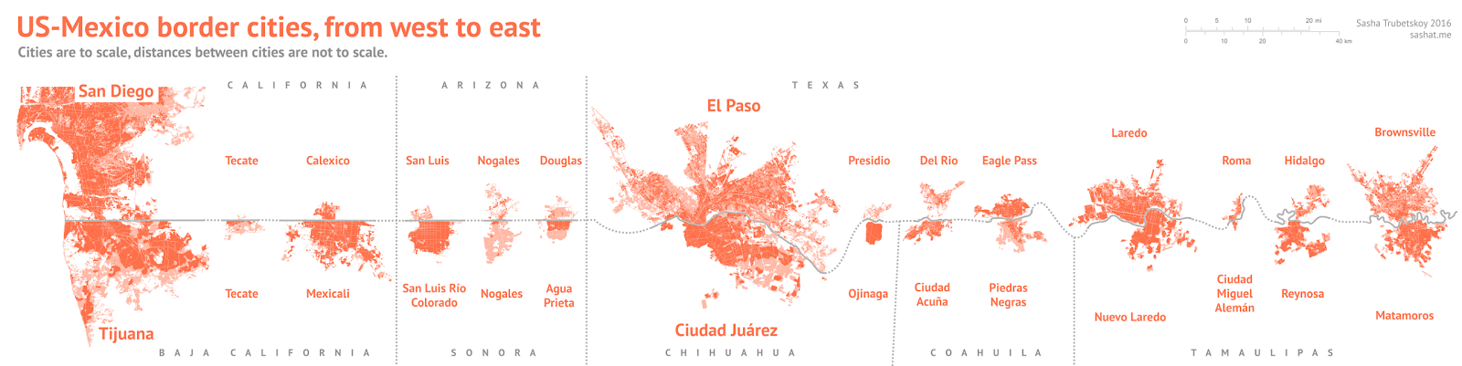
Trump Wants a Border Wall. See What’s in Place Already.
Most U.S. border land east of El Paso, Tex., is privately owned. To the west, most of the land is owned by the federal government.
The government has built nearly 700 miles of wall and fencing since 2006, mostly on federal land and where the terrain does not provide a natural barrier.
Some of the fencing is tall — higher than 10 feet — and concentrated near populated areas.
And more than 16,000 Border Patrol agents work across nine sectors.
People usually pass through one of 25 official crossings that dot the border.
Most of the hard drugs that are smuggled into the United States come through these crossings — or under them. Hundreds of smuggling #tunnels snake under border towns like #Nogales, in Arizona.
Checkpoint America : Monitoring The Constitution #Free_Zone
#Checkpoint_America: Monitoring The Constitution-Free Zone is a new Cato project designed to map Department of Homeland Security Custom and Border Protection (CBP) internal checkpoints and provide the public with information on their operations, as well as the chance to help improve our information on and understanding of activities at these checkpoints.
Simply stated, Americans living in or traveling through the so-called “border zone” can be subjected to motor vehicle stops and constitutionally dubious searches at internal checkpoints run by the CBP. Some of these checkpoints are located as much as 100 miles inside the country, and reports of CBP agent abuses of citizens at such checkpoints appear frequently in the press.
If you conduct a YouTube search utilizing the phrase “checkpoint refusal videos,” you will get thousands of hits-and you could easily spend days watching them. One Arizona man has created Roadblock Revelations, a website dedicated to exposing CBP abuses of motorists (the website operator has to travel through a CBP checkpoint daily in order to get to and from work). A ReasonTV piece documented the case of one American citizen who, upon refusing to disclose his citizenship at the Laredo, Texas checkpoint, was detained by CBP without charge for 19 days (the case was the subject of litigation). In some cases, CBP agents have used #violence to remove motorists from their vehicles when they decline to answer questions after asserting their rights.
In October 2013, the Arizona ACLU chapter filed a complaint with the DHS’s Inspector General office regarding CBP mistreatment of multiple Arizona residents at checkpoints in the state. The abuses at these checkpoints have become so serious that the ACLU has initiated the Border Litigation Project, which seeks to monitor and combat in court CBP’s excesses at the checkpoints. A 2015 Freedom of Information Act request to CBP filed by Cato Policy Analyst Patrick Eddington for information on these checkpoints has been on administrative appeal for two years-a clear effort by CBP to block release of information related to the length of motorist stops for “secondary” inspections, as well as the number of use-of-force incidents.
On the map below, you can click on individual checkpoints to view overhead and ground-level photography of the facilities, physical descriptions of the checkpoints, and read (where available) press accounts, administrative actions, and court proceedings involving a given checkpoint.
If you have comments, questions, or suggestions about how this online CBP checkpoint monitoring tool can be improved, contact Patrick Eddington at peddington@cato.org. Share what you learned on Twitter with the hashtag #CheckpointAmerica.
Petite mise en garde sur cato.org :
#CATO, c’est un think-tank ultra-libéral (anti-Etat)
Maps U.S. Border Barriers by Kenneth D. #Madsen
 https://cpb-us-w2.wpmucdn.com/u.osu.edu/dist/2/14781/files/2017/08/California_v379_2017-08-02-waiver_c-1943i5n.jpg
  https://cpb-us-w2.wpmucdn.com/u.osu.edu/dist/2/14781/files/2017/07/California_v378_poster-e-tpu81t.jpg
 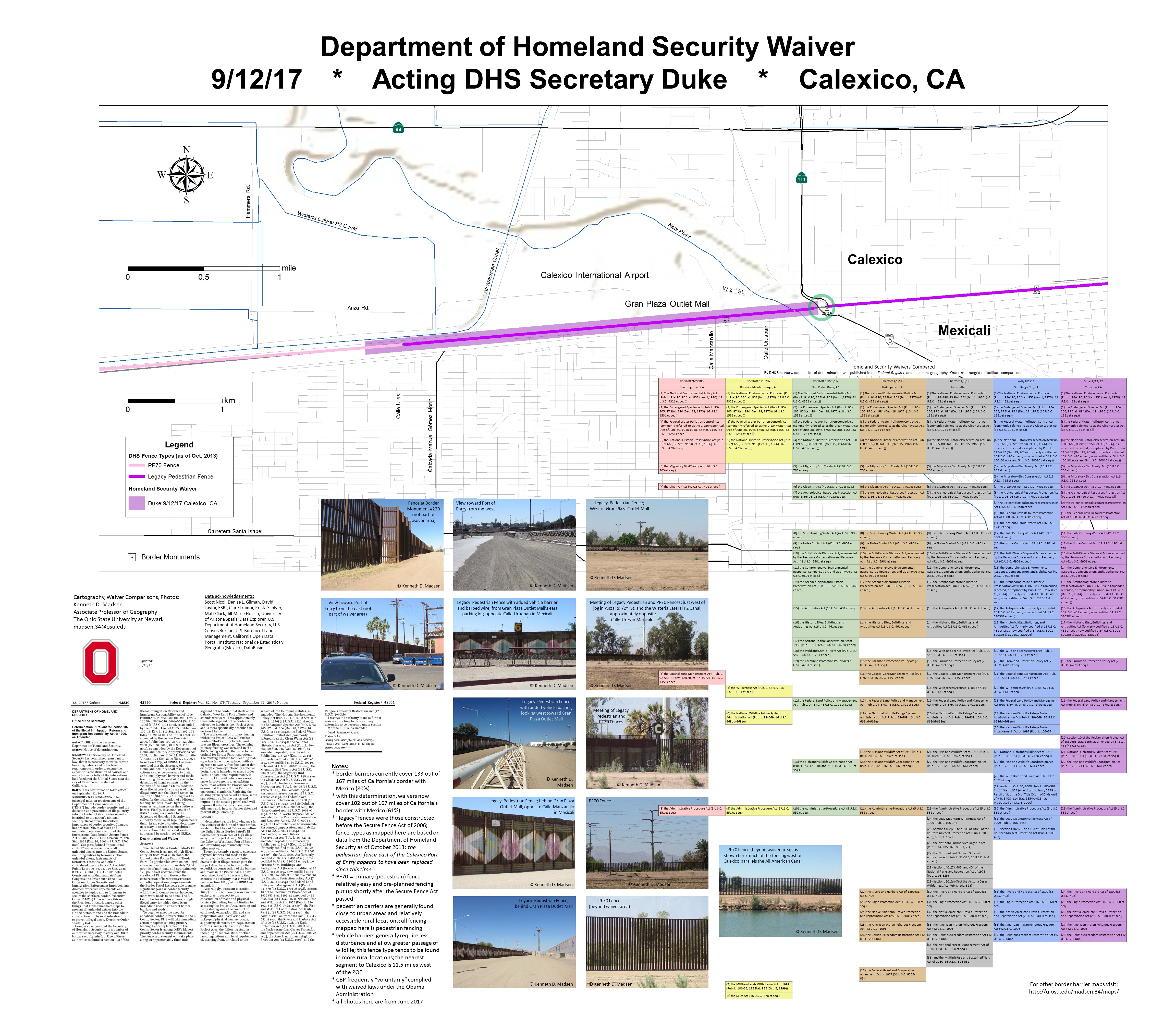 https://cpb-us-w2.wpmucdn.com/u.osu.edu/dist/2/14781/files/2017/09/California_v386_2017-09-12-waiver_Calexico-1jyg0mn.jpg
  https://cpb-us-w2.wpmucdn.com/u.osu.edu/dist/2/14781/files/2017/07/Arizona_v378_poster-e-2kehasc.jpg
 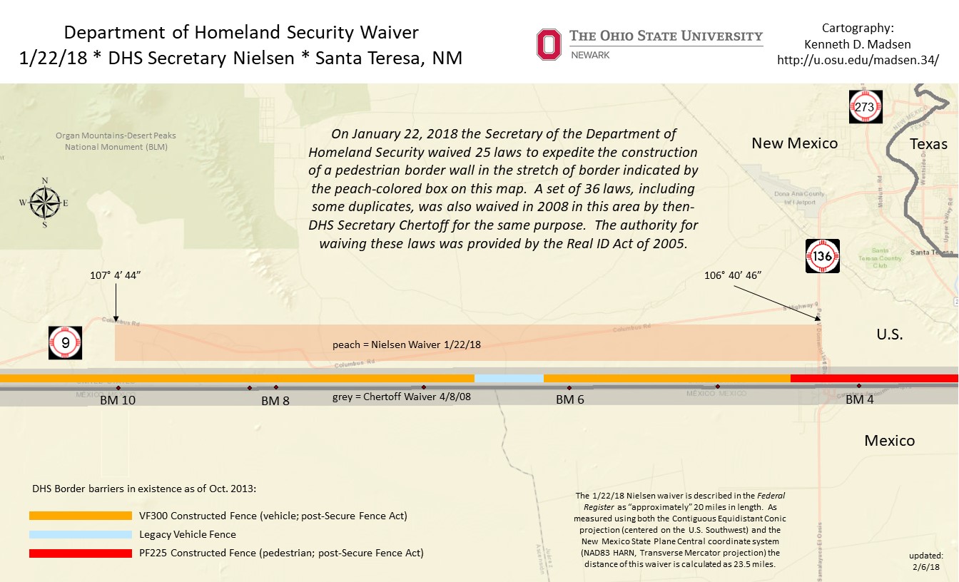 https://cpb-us-w2.wpmucdn.com/u.osu.edu/dist/2/14781/files/2018/02/NM_Nielsen_2018-01-22_waiver_SantaT_v04-1jvftes.jpg
Map of proposed border wall released
We’re now getting a clear picture of where more than 60 miles of border wall will be built in Webb and Zapata counties thanks to the newly released map from the federal government.
"This is more than just a big ugly fence that turns our city into a prison yard, this represents government seizing private land, seizing our land and not just for this generation, but for generations in the future,” said Melissa Cigarroa.
As more and more information about the proposed border wall comes to light, Rio Grande International Study Center Board President, landowner, and advocate Melissa Cigarroa says it’s getting harder to imagine how life will be without the simple pleasures she and her family enjoy in the piece of land they have along the river.
“We bought that land so we can have river access and enjoy fishing on the river that’s exactly where they want to put the wall.”
Cigarroa is one of the many landowners whose property lies within the border wall miles. An email from the federal government sheds light on where the wall will be.
There is approximately 69 miles of CBP funded border wall being proposed in Webb and Zapata County. That is in addition to the border wall system that is being funded and constructed by the department of defense.
We’re unsure of which local community leaders have received this new map.
However, we do know that Zapata County Judge Joe Rathmell was shown the updated map by CBP this morning.
“I guess we’re getting a clearer picture of what exactly we’ll be looking at.”
On Monday, Zapata County unanimously voted against allowing the federal government to their property to survey land for the border wall.
"What we were addressing yesterday were two small tracts of land that the county owns, around the campsite of San Ygnacio, the areas of Zapata County that are going to be affected with this phase of construction would be areas from San Ygnacio north to the Webb County line.”
Zapata along with the City of Laredo have denied right of entry, but Webb County has not.
To see the full maps you can click here: ▻http://media.graytvinc.com/documents/FY+2020+Laredo+Border+Wall+System+Projects+Request+for+Input_ENGLIS.
▻https://media.graytvinc.com/images/690*388/map3.PNG
▻https://www.kgns.tv/content/news/Map-outlines-where-border-wall-construction--568195211.html


