OpenLayers Themes / Mapping 101 / FAQs - MapBox Support
►http://support.mapbox.com/kb/mapping-101/openlayers-themes
un set de controles plus sympa pour openalyers (vectoriels disponibles)
#gis #openlayers #map
OpenLayers Themes / Mapping 101 / FAQs - MapBox Support
►http://support.mapbox.com/kb/mapping-101/openlayers-themes
un set de controles plus sympa pour openalyers (vectoriels disponibles)
#gis #openlayers #map

Carte des emprunts toxiques
►http://labs.liberation.fr/maps/carte-emprunts-toxiques
Carte des emprunts structurés, dits « toxiques », distribués par Dexia Crédit local (DCL), de 1995 à 2009, et encore en exercice début 2010. Il est indiqué le montant de ces emprunts, le surcoût attendu pour les collectivités, tel qu’il est valorisé par DCL, ainsi que les banques qui ont servi de contrepartie à DCL.

Leaflet - a modern, lightweight JavaScript library for interactive #maps by CloudMade
►http://leaflet.cloudmade.com
Leaflet is a modern, lightweight BSD-licensed JavaScript library for making tile-based interactive maps for both desktop and mobile web browsers, developed by CloudMade to form the core of its next generation JavaScript API.

Amazing #maps show #Twitter and #Flickr activity around the world - Telegraph
►http://www.telegraph.co.uk/technology/twitter/8638292/Amazing-maps-show-Twitter-and-Flickr-activity-around-the-world.html?ima
Judging from this map of Europe, it is clear that Twitter is most popular in Britain and the Netherlands


Underscore.js
►http://documentcloud.github.com/underscore
#functional_programming support that you would expect in Prototype.js (or Ruby), but without extending any of the built-in #JavaScript objects. It’s the tie to go along with jQuery’s tux.
Underscore provides 60-odd functions that support both the usual functional suspects: #map, #select, #invoke — as well as more specialized helpers: function #binding, javascript #templating, deep equality testing, and so on. It delegates to built-in functions, if present, so modern browsers will use the native implementations of forEach, map, #reduce, #filter, every, some and indexOf.

Put a thousand books from the British Library on your #iPad
►http://www.tuaw.com/2011/06/12/put-a-thousand-books-from-the-british-library-on-your-ipad-for-f
The British Library has released 1000 books from its 19th Century collection into a free iPad app that includes novels, historical works, poetry, philosophy and scientific books.
The books have been scanned in high resolution and color so you can see the engraved illustrations, the beauty of the embossed covers, along with #maps and even the #texture of the paper the books were printed on.
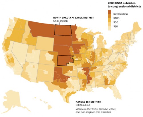
U.S. food politics in action
►http://www.foodpolitics.com/2011/06/u-s-food-politics-in-action
For an instant tutorial in U.S. food politics, take a look at this Washington Post #map of where agricultural subsidies go.

Vos déplacements, à la #carte | Andréa Fradin
►http://owni.fr/2011/06/13/vos-deplacements-a-la-carte
En intégrant les réseaux de transports en commun de nombreuses villes à travers le monde, Mapnificient vous propose de visualiser tous les endroits où vous pouvez vous rendre en un temps donné. Pratique et esthétique.
#Cultures_numériques #Opendata #Google_Maps #map #mapnificience #visualisation

Vous êtes plutôt #SQL ou bien vous êtes plutôt #MapReduce pour l’analyse de vos grosses quantités de données ? Ne pleurez pas devant la difficulté du choix, vous pouvez combiner les deux, dit le projet #HadoopDB :
►http://db.cs.yale.edu/hadoopdb/hadoopdb.html
L’article original :

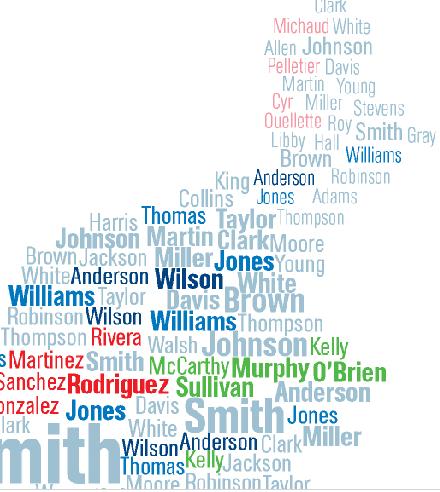
#Maps of #Surnames » Sociological Images
►http://thesocietypages.org/socimages/2011/02/05/maps-of-surnames
the concentration of last names serves as an echo of immigration and settlement patterns. British-origin names tend to dominate across the U.S., unsurprisingly, particularly Smith, Johnson, and Williams. Because slaves were often given the last names of their owners, a significant proportion of individuals with British last names are African American — for instance, African Americans are about 20% of people named Smith.
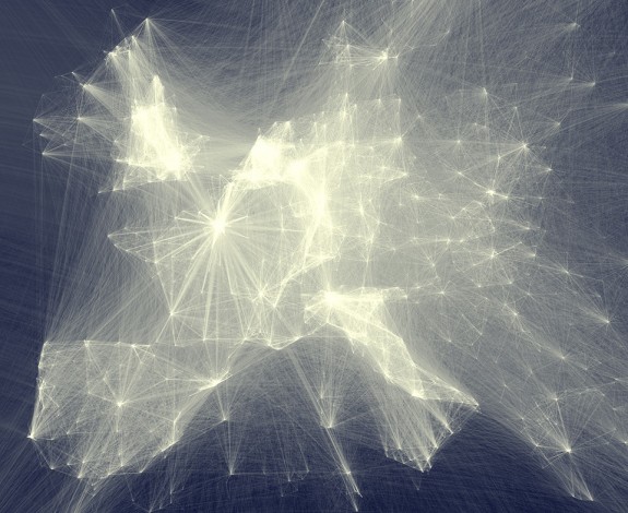
Map of scientific collaboration between researchers
►http://flowingdata.com/2011/01/27/map-of-scientific-collaboration-between-researchers
scientific collaboration around the world from 2005 to 2009:
From an extensive database of academic citations:
I extracted and aggregated scientific collaboration between cities all over the world. For example, if a UCLA researcher published a paper with a colleague at the University of Tokyo, this would create an instance of collaboration between Los Angeles and Tokyo.
#seenthis_bug : j’ai été obligé de remplacer dans l’URL le tilde par un %7E, sinon ce n’était pas pris en compte


Experiments in Map-Making « The Moor Next Door
►http://themoornextdoor.wordpress.com/2010/10/26/experiments-in-map-making
Below are some rough, experimental maps that attempt to show some of the priorities discussed last week’s post on some of the politics between the various actors in the Maghreb-Sahel region. Nothing here is perfectly depicted or with total accuracy, but they are a start toward … something. [UPDATE: Another map, after the jump.]
jQuery maphilight documentation
►http://davidlynch.org/js/maphilight/docs
“maphilight applies to images with a ’usemap’ attribute, and outlines the areas defined in their map on mouseover.”
#usemap #carte #image #cliquable #zone #maphilight #jQuery #plugin #javascript #clevermarks
wimt.fr - Where Is My Train?
►http://wimt.fr
#mashup #demo #exemple #Mappy #RER #carte #train #géolocalisation #clevermarks
Mapzen POI Collector - the only iPhone OpenStreetMap mapping application
►http://mapzen.cloudmade.com/mapzen-poi-collector
“Mapzen POI Collector lets you add businesses, local amenities and other places of interest to OpenStreetMap – all from one free, easy to use iPhone application”
Entering The Wonderful World of Geo Location - Smashing Magazine
►http://www.smashingmagazine.com/2010/03/08/entering-the-wonderful-world-of-geo-location
#geographie #maps #ip #per.sonn.es #spip