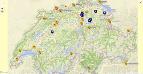
Pour les gens qui utilisent un ordi avec une pomme dessus :
▻https://www.youtube.com/watch?v=Mi14GK2TX7U
▻http://alper.nl/dingen/2015/12/osm-live-edit-screensaver
Par contre ça doit générer un sacré trafic réseau tout ça :p
#osm
Pour les gens qui utilisent un ordi avec une pomme dessus :
▻https://www.youtube.com/watch?v=Mi14GK2TX7U
▻http://alper.nl/dingen/2015/12/osm-live-edit-screensaver
Par contre ça doit générer un sacré trafic réseau tout ça :p
#osm
Maps + algorithms to bring infrastructure and services to urban slums worldwide
This year, Stamen has been working with the Santa Fe Institute and UC Berkeley College of Environmental Design for Slum Dwellers International to create Open Reblock, a public interface for their innovative research to develop better planning and development tools for informal settlements. The result is a publicly available tool at ▻http://openreblock.org. It takes maps of existing buildings and roads or paths and uses a sophisticated algorithm to create a map showing how city infrastructure and services can be brought to informal settlements with the least disruption for existing communities and their residents.
Informal settlements are part of cities worldwide, and they’re growing rapidly. Some demographers estimate that virtually all of the population growth on the planet in this century will effectively be absorbed by informal settlements. A single city “block” in informal settlements can have hundreds of residences, most without direct street access. It’s difficult to provide services, roads, water, and sewage, in these situations. One reason often cited for either doing nothing or for the demolition and redevelopment of these settlements is their lack of easy access for infrastructure and services. Open Reblock provides an alternative — a way forward for integrating services in existing informal settlements, respecting these communities, while helping them gain access to essential services. It does this by generating maps to connect as many parcels as possible — up to all of the parcels — in a block to roads and utilities.
via ▻http://content.stamen.com/open_data_essential_infrastructure
Né en 1888, Søren Poulsen a passé les 25 dernières de sa vie de 1943 à 1969 à construire une carte du monde de 4000m² au bord du lac Klejtrup au Dannemark.
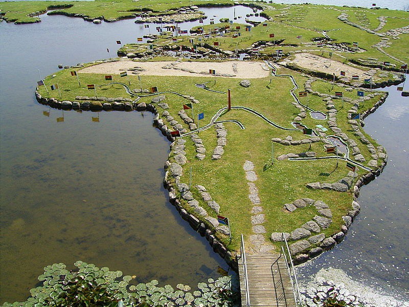 http://www.laboiteverte.fr/wp-content/uploads/2015/11/carte-monde-lac-dannemark-01.jpg
 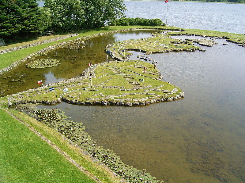 http://www.laboiteverte.fr/wp-content/uploads/2015/11/carte-monde-lac-dannemark-03.jpg
 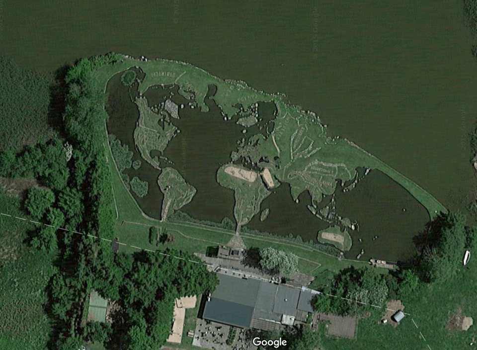 http://www.laboiteverte.fr/wp-content/uploads/2015/11/carte-monde-lac-dannemark-10.png
 ▻http://www.laboiteverte.fr/la-carte-du-monde-au-bord-du-lac
#map


Haha c’est taré ! Avec les grands cours d’eau et les déserts !
#cartographie #lac


J’espère qu’il a géré le relief pour faire des maj de sa carte en faisant monter le niveau de l’eau...
Using OpenStreetMap Data with Open-Source GIS | Markieta | Cartographic Perspectives
▻http://cartoperspectives.org/index.php/journal/article/view/cp71-markieta/138
INTRODUCTION
For many, free and open-source data and software represents accessibility to otherwise inaccessible geospatial workflows in terms of cost and availability. Commercial data used in geographic information systems (GIS) is available through a relatively small number of merchants or vendors, which produce highly accurate, precise, and detailed information. This is produced, however, at a cost that many small and large businesses, private consultants, and startups cannot afford. Open-source data, such as the volunteer geographic information on OpenStreetMap (OSM), represents a community effort to build one of the best web maps, and subsequently the best GIS database, available for free to the public. OpenStreetMap is a web-based map to which any registered user can submit data. These updates, over time, populate the now extensive web map that is the OpenStreetMap. At the same time, the data that lives on the OpenStreetMap can be downloaded and used inside of a GIS for geospatial analysis, cartographic rendering, and other geo-related tasks.
There are various workflows for extracting and consuming the data that is made available by the OpenStreetMap project. One of these methods is outlined in this tutorial. This tutorial will take Mac OSX users through a typical setup of a local PostgreSQL database, downloading and parsing raw OpenStreetMap data, and querying the database to extract data for use in QGIS, an open-source GIS package. Upon completing this tutorial, users will have hit the ground running, with the ability to run spatial queries—such as locating all the coffee shops within 500 metres of a subway station—or building cartographically pleasing reference map books with data that is of interest to the map reader.
THIS TUTORIAL WILL COVER THE FOLLOWING:
Access and browse an OSM data repositories
Download a subset (often called an “extract”) of the planet.osm data package
Install PostgreSQL (object-relational database system)
Install PostGIS for use with PostgreSQL (spatial database extension for PostgreSQL)
Install and utilize osm2pgsql (converts OSM data for use in the PostgreSQL database)
Install QGIS and its dependencies (GIS package)
Query and add data in QGIS from PostGIS/PostgreSQL
Sorted Cities
▻http://hanshack.com/sorted-cities
’Sorted Cities’ is an ever-growing collection of posters, based on #building footprints that have been sorted by size and shown in proportion to each other.The tool uses data from OpenStreetMap.
#osm
Geometa Lab HSR Blog — Easy web #map creation with OpenStreetMap data using #umap and #overpass
▻http://geometalab.tumblr.com/post/130632772622/easy-web-map-creation-with-openstreetmap-data
This blog shows how to integrate up-to-date OpenStreetMap (OSM) data into the free web map publishing tool uMap. To query the geometries from the #osm database the web-based tool Overpass Turbo will be used.
Trending Tags on #osm
▻https://hashtags.developmentseed.org
Edits et tags utilisés sur osm en direct.
Présentation : ▻https://developmentseed.org/blog/2015/09/28/whats-trending-osm
Code source : ▻https://github.com/developmentseed/planet-stream
#map

From #JOSM search & replace to processing #Openstreetmap with your favorite text edition tools
▻http://serendipity.ruwenzori.net/index.php/2015/08/25/from-josm-search-replace-to-processing-openstreetmap-with-you #OSM #XML #Perl
Bonne nouvelle !
The OSM-based and open source Geo Search Engine Photon now also supports “Reverse Geocoding”, i.e. output of address to a transferred X / Y coordinate.
▻http://www.weeklyosm.eu/archives/4639
Je viens de brancher le plugin #GIS pour #SPIP dessus pour tester, mais malheureusement #photon ne renvoie pas autant d’informations que #nominatim pour l’instant (?). On verra ça plus tard...
#osm
Et il est censé être mieux ?

« mieux » je ne sais pas, il utilise les mêmes données que nominatim, mais l’infra derrière permet de faire de l’auto-complétion sans problème.
@ybon pourra certainement t’en dire plus :)
the other openstreetmap churches post (tecznotes)
▻http://mike.teczno.com/notes/openstreetmap-churches.html
What is the easiest way to #extract a list of a specific type of features from #osm for a particular area?Since you’re asking for a major urban area, I would expect that London is part of the Mapzen metro extracts.Then I used ogr2ogr, a tool in the #gdal family, to quickly peel out all the tag matches. I could do this interactively in QGIS as well, but I find the command line to be a speedier way to get what I want.
#map


« On peut créer des alternatives à Google avec le logiciel libre »
▻http://www.lemonde.fr/festival/article/2015/07/04/on-peut-creer-des-alternatives-a-google-avec-le-logiciel-libre_4670378_44151
On vient de franchir une étape fondamentale, celle de la co-création du premier jeu de données d’adresses. La base adresse est consultable sur le site data.gouv.fr où l’on trouve à la fois les jeux de données libérés par la communauté d’OpenStreetMap, et ceux des services de l’Etat, l’IGN et la Poste, ainsi que des outils pour les utiliser. L’enjeu est fondamental en terme d’innovation et d’indépendance. L’adresse, c’est la première chose dont on a besoin pour retrouver son chemin, calculer son itinéraire, effectuer des livraisons, secourir des blessés...
#openstreetmap #opendata cc @severo @adsib


Oui c’est une excellente idée que l’État libère les données qui sont de caractère public, et considère #OSM comme un allié et pas comme un concurrent. J’espère qu’on pourra faire la même chose ici en Bolivie, il y a justement un projet en cours d’élaboration pour un « registro domiciliario », on va essayer de proposer cette solution.
Et aussi proposer l’utilisation de #geohash, qui est bien adapté dans un pays où la poste est moribonde, le code postal n’existe pas, et les numéros dans les rues n’existent pas toujours (et dans le « campo », pas de rue, pas d’adresse). Un peu sur le modèle irlandais avec #eircode :
OpenStreetMap | escada’s diary | Don’t know what to think of it of this research
▻https://www.openstreetmap.org/user/escada/diary/35244
Somewhere in April, I bought a smartphone and installed OsmAnd on it. During my first ride with it, I discovered that someone tagged a stretch of an highway with maxspeed=50. I noticed it, because OsmAnd suddenly warned my that I was speeding. The same day I changed it back to the normal 120 and I left a changeset comment. Today I got a reply to that comment (in Dutch): “Deze werd in #osm geplaatst voor een onderzoek naar de temporele kwaliteit van OpenStreetMap. Alle gemaakte fouten, die nog niet verbeterd werden door de gemeenschap, worden vandaag verbeterd.” The translation is something like "Those errors were placed into OSM for a research in the temporal quality of OpenStreetMap. All deliberately made mistakes, that are not yet corrected by the community, will be (...)
How straight or bendy are the roads?
▻http://www.technomancy.org/openstreetmap/bendy-roads
Using OpenStreetMap (OSM) data, I was able to see how bendy or straight the roads are all over the world. One theory I had was that Europe, where current roads are based on older roads that predate cars, would have more bends and curves than the USA, where current roads were (in many places) only put in in the last 150 → 100 years, and probably put in directly and dead straight.

Je me demandais pourquoi il n’existait pas encore de calculateur d’itinéraire GR. Réponse dans ce billet de Christian Quest, le président d’OSM :
GR® ? Grrrrr®... :(
Depuis des années, la communauté française des contributeurs OpenStreetMap se pose régulièrement des questions sur le statut des itinéraires de randonnée en France.
OSM permet en effet de cartographier des itinéraires officiels, pour les partager librement et dans de nombreux pays ceci ne soulève aucune question particulière.
Dans des pays voisins comme la Belgique, l’organisme chargé des sentiers de randonnées s’appuie même sur OpenStreetMap pour diffuser ces itinéraires et sur un fond de carte OSM pour diffuser des guides destinés aux randonneurs.
Quel problème y a-t-il alors en France ?
La Fédération Française de Randonnée Pédestre (FFRP) a par le passé attaqué certains éditeurs qui avaient reproduit des itinéraires. Elle a fait valoir que ceux-ci étaient une « oeuvre de l’esprit » et donc couverts par le droit d’auteur. A notre connaissance, deux procédures (seulement) ont donné une fois raison et une fois tort à la FFRP.
Sans doute craignent-ils une démocratisation incontrôlée de l’utilisation de ces sentiers... Faut toujours faire gaffe avec la démocratisation (et un grand merci à la FFRP pour veiller de la sorte à la protection de ce patrimoine de toutes les hordes sauvages qui risquent de déferler sur les sentiers !).

@biggrizzly hum je ne pense pas, à côté de ça, la FFRP a fait un énorme travail pour que la randonnée soit un sport/loisir populaire. Hiatus de culture plutôt ?
De mon point de vue, la seule chose que je vois, c’est que quand je me balade, pas moyen de connaître les sentiers sans acheter la carte du coin, carte que je ne vais utiliser qu’une seule fois. Je comprends qu’il y ait des affaires de sous, mais là, pour le moment, les solutions pour les résoudre ne me parlent pas. Et j’avoue être profondément frustré quand je voyage sans savoir s’il y a un GR ou pas proche de là où je suis...

@biggrizzly mon expérience me pousse plus a dire qu il suffit d aller dans les syndicat d initiative pour trouver bonheur gratuit à son pied de marcheur et pour ceux ci s entêtent à vouloir te faire payer, trouver le troquet du coin (pas le bobo hein, celui avec les vieux qui boivent le coup) et causer une ou deux tournée avec eux... Bon, t auras pas forcément les GR mais les ballades valent le coup en général, si tu ne te perd pas dans les explications des locaux (ce qui m’est arrivé une paire de fois... D ou des ballades beaucoup plus longues que prévues... Mais après, j imagine que certains ont plus de mémoire que moi :) )

Tu as raison @corinne2, mais je suis un indécrottable citadin qui n’ose pas adresser la parole aux « gens du coin », quand ils existent encore ! :-D On finit toujours pas trouver son bonheur sur place, c’est vrai.
il y a aussi des app super cool comme Wikiloc, bon ok payante pour du parcours géolocalisé en temps réel, mais ça reste raisonnable, ça comble un manque, et c’est collaboratif.

J’ai aussi remarqué que les sentiers et de chemins de randonnées ou de vélo sont en quelque sorte privatisés par les OT et ça me gonfle.
Mise en place et utilisation d’un serveur BAN/BANO pour un usage personnalisé sous Ubuntu 14.04
▻http://geotribu.net/node/811
Dans une deuxième temps, nous introduisons la Base Adresse Nationale (BAN) et la Base Adresse Nationale Ouverte (BANO, historique). En effet, danc ce contexte, des outils pour géocoder ont été mis en oeuvre. Nous expliquerons comment les utiliser, comment installer un serveur pour géocoder chez vous si par exemple, vous avez des besoins de géocodage massif ou de personnaliser la recherche d’adresse avec vos critères lors du géocodage.


Un gros bienvenu sur seenthis à @shenriod !!!
Grand spécialiste de #GIS, #cartographie, #OSM et... #Asie_centrale.
On attend tes trouvailles !
cc @reka @fil
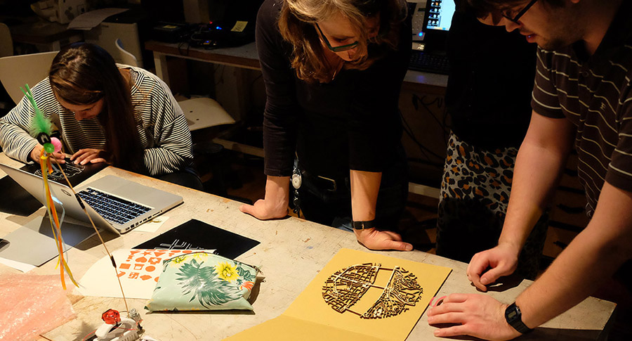
Cartographie avec SPIP
Développement avec la librairie Leaflet et dérive sur les fonds de cartes du plugin GIS. Ce plugin permet l’intégration de cartes et la géolocalisation des objets de SPIP. Il utilise la librairie Leaflet et propose plus de 25 fonds de carte différents, dont la plupart sont basées sur les données OSM.
▻https://wiki.openstreetmap.org/wiki/FR:State_of_the_Map_France_2015#Apr.C3.A8s-midi_2

vires moi mon pseudo de ton truc de comm’ :D
Non je déconne... (enfin juste un peu)
Claque une bise à C. Quest et Yohan si tu les croises.
mais bon ça fait quand même un bail que je t’ail laissé tout seul sur ce coup là :(
Mais je reprends du service, on va faire GIS 5.0
Si t’as une todo c’est le moment de la sortir...
Il y aura à terme au moins deux fonds de cartes supplémentaires ;)
tu sais que ``[(#INCLURE{fond=modeles/carte_gis,` ça s'écrit aussi `#MODELE{carte_gis...`` au fait :p
ah ben c’est déjà passé.... t’es pas doué en com toi... surtout que j’aurais pu venir :(

@kent1 arf dommage, mais si tu traînais plus sur irc tu l’aurais su, na :p
nouveau troll sur la #licence des données #osm :
Gary Gale : “Dear OSM, it’s time to get your finger out” ▻http://geohipster.com/2015/04/27/gary-gale-dear-osm-its-time-to-get-your-finger-out
deux réponses :
Is it the moment for OpenStreetMap ? ▻http://www.openstreetmap.org/user/Zverik/diary/34864
Dear OSM, just chill out ▻http://geomaticblog.net/2015/04/27/dear-osm-just-chill-out
laisse tomber la neige, ça ne fait pas de bruit...
City Layouts on Behance
►https://www.behance.net/gallery/24276859/City-Layouts
▻https://m1.behance.net/project_cover?proj_id=24276859&size=404
Topography, architecture and traffic routes give every city a unique structure.
These conditions create the typical and individual inner structure of a city.
I didn’t only want to show these structures in the conventional way from above, but also including the exact three-dimensionality of topography and buildings - a real world visualisation.
The OpenStreetMap data enabled me to visualize the satellite-based information using DEM Earth in Cinema 4D. The results are some extraordinary views of large capitals and small towns.
Series of gallery quality art prints for sale on Society6
Specific cities or perspectives are available on request.
#cartographie #3D #osm
OpenStreetMap | nebulon42’s diary | Osmic (OSM Icons) 0.1
▻http://www.openstreetmap.org/user/nebulon42/diary/34709
I’m happy to announce the availability of the first release 0.1 of Osmic (OSM Icons). Osmic is a collection of 100+ clean high quality SVG icons optimised for small sizes. The icons are licensed under Public Domain (or CC0). Have a look at the Github repository: ▻https://github.com/nebulon42/osmic
#map #osm #icone #creativecommons
C’est disponible en font ?

@rastapopoulos nope ça ne semble pas, mais bientôt peut-être si quelqu’un s’y colle :)
Yep, j’ai posé la question en commentaire ainsi que l’intégration à Fontello.
Et hop, il a fini par mettre les icônes dans une font après ma proposition :
▻http://www.openstreetmap.org/user/nebulon42/diary/34709#comment30540
Maintenant l’étape suivante ce serait de demander à Fontello d’intégrer cette font dans leurs jeux de base.
J’ai fait un ticket pour le demander :
▻https://github.com/fontello/fontello/issues/406
Bicycle - osm24
Simple website created with overpass API.
annonce : ▻http://forum.openstreetmap.org/viewtopic.php?id=30522
sources : ▻https://github.com/dotevo/bicycle-overpass
OpenTopoMap - Topographische Karten aus OpenStreetMap
▻http://opentopomap.org/#map=5/47.220/3.955
Cool, bientôt un nouveau fond de carte dans le plugin #GIS pour #SPIP :)
Et hop, elle est dispo dans GIS 4.26.9 :
Il est très beau ce fond.
Avec le relief de La Paz, ça va être plus sympa que le fond actuel de GeoBolivia qui n’a pas de lignes de niveau - on dirait que c’est tout plat
▻http://geo.gob.bo/mapfishapp/map/181a81be4602c3e3a6e6a8f16a0ddaf3
Pas de bol, opentopomap ne génère pas le fond pour nous :
▻http://opentopomap.org/#map=11/-16.4940/-68.1475
Avec GeoBolivia, on va tenter de le générer avec les données #OSM et #SRTM, je donnerai des nouvelles si on y arrive.
GeoDNS - tile.openstreetmap.org
▻http://dns.openstreetmap.org/tile.openstreetmap.org.html
Tabaluga primarily served traffic to visitors from Germany. Approximately 56 million map tiles per day. (avg 652/sec, peaking at 1245/sec). Serving close to 1TB of data per day. It was the highest traffic #osm tile cache #server.
▻https://blog.openstreetmap.org/2015/03/24/openstreetmap-tile-cdn-continues-to-grow
Maptime AMS - Street patterns !
▻http://maptime-ams.github.io/street-patterns
This is a tutorial on using OpenStreetMap road data to make physical visualizations using Fablab equipment. Follow along, and don’t forget to click on all the links to read some background information!
source dispo par ici : ▻https://github.com/maptime-ams/street-patterns
Setting up a Pelias Instance
▻https://mapzen.com/blog/pelias-setup-tutorial
Pelias is a modular open-source #geocoder using ElasticSearch for fast autocomplete and forward and reverse geocoding. It’s designed to support a variety of datasets, including #Geonames, Quattroshapes, #osm, and whatever else you can throw at it. Take a look at the demo to see what it can do right now and check out the work we’re currently doing on Github.
#map