• Street Scenes from the East End, 1950-1980
    https://autograph.org.uk/online-image-galleries/bandele-tex-ajetunmobi

    Bandele ‘Tex’ Ajetunmobi was a self-taught photographer who stowed away on a boat to Britain from Lagos, Nigeria in 1947. He chose to leave Lagos as he found himself an outcast on account of the disability he developed from having polio as a child.

    After settling in East London, he began recording the daily lives of his friends and acquaintances, particularly on the streets and in the pubs, shops and clubs around Whitechapel, Stepney and Mile End. He continued to document the area for almost half a century, focusing on immigrant communities and the multi-racial nature of the area.


    photo Bandele ‘Tex’ Ajetunmobi
    #photographie

  • ONE YEAR!
    Photographs from the miners’ strike 1984 - 85
    https://www.martinparrfoundation.org/exhibitions/one-year

    To coincide with the 40th anniversary of the miners’ strike this exhibition will look at the vital role photographs played during the year-long struggle against pit closures, including many materials drawn from the Martin Parr Foundation collection. The miners’ strike was one of Britain’s longest and most bitter disputes, the repercussions of which continue to be felt throughout the country today.


    Miners Strike 1984 mass picket confronting police lines, Bilston Glen. Norman Strike at the front of a mass picket, Scotland. © John Sturrock/Reportdigital.co.uk

    via https://www.theguardian.com/artanddesign/2024/jan/11/1984-miners-strike-photography-martin-parr-foundation

    ‘The officer could have smashed her skull’: the 1984 miners’ strike in pictures

    #photographie #grève

  • Dessins de hasard : Anima Sola #30
    Récit poétique à partir d’images créées par procuration.

    https://liminaire.fr/palimpseste/article/dessins-de-hasard

    La nuit est un long chemin qui serpente dans les sous-bois, quelques flaques d’eau forment des miroirs au sol. La brume épaissit à mesure qu’on avance. Le paysage se transforme lentement. Difficile de voir à quelques pas devant soi, parfois une lumière vacille au loin, tremblante à peine, cela ressemble à un signal secret, un repère dans la nuit, on pense s’approcher du but, à destination, mais c’est une illusion passagère, lumière chavire avant de basculer dans le noir. La nuit s’obscurcit toujours un peu plus. Bleu nuit sur fond noir....

    (...) #Écriture, #Langage, #Poésie, #Lecture, #Photographie, #Littérature, #Art, #AI, #IntelligenceArtificielle, #Dalle-e, #Récit, #Nature, #Nuit, #Paysage, #Lumière, (...)

    https://liminaire.fr/IMG/mp4/anima_sola_30.mp4

  • Documenter l’anthropocène ?
    https://metropolitiques.eu/Documenter-l-anthropocene.html

    Comment photographier les destructions écologiques en cours tout en maintenant un point de vue critique sur « l’anthropocène » ? Le dernier ouvrage de Danièle Méaux étudie les conditions de possibilité d’un regard critique et réflexif, pour le photographe comme pour ses publics. Ce nouvel ouvrage de Danièle Méaux, professeure en esthétique à l’université de Saint-Étienne, s’inscrit dans le sillage de Géo-photographies et Enquêtes, parus également chez Filigranes en 2015 et 2019. Poursuivant un tour d’horizon #Commentaires

    / #arts, #photographie, #anthropocène, #écologie, #paysage, #environnement, #représentation

    https://metropolitiques.eu/IMG/pdf/met_gaudin9.pdf

  • Périple autour du #vernaculaire américain
    https://metropolitiques.eu/Periple-autour-du-vernaculaire-americain.html

    Comment décrire, encore, les architectures et paysages américains ? Trois architectes françaises ont mené une exploration écrite et graphique de l’est des #États-Unis, dont rend compte l’ouvrage richement illustré What about vernacular ?. En 2023, est paru aux éditions Parenthèses What about vernacular ?, ouvrage de 384 pages dont les autrices sont les architectes Justine Lajus-Pueyo, Alexia Menec et Margot Rieublanc. D’emblée le titre What about vernacular ? positionne la proposition de Lajus-Pueyo, #Commentaires

    / #architecture, vernaculaire, États-Unis, #voyage, #photographie, #dessin, #paysage

  • Alice Springs Retrospektive
    https://www.rbb-online.de/rbbkultur-magazin/archiv/20230603_1830/springs-alice-newton-fotografin-ausstellung-museum-fuer-fotografie-retros

    J’ai vu l’expo. Vous n’avez rien manqué. Voire https://seenthis.net/messages/1034120

    Sa 03.06.2023 | 18:30 | rbbKultur - Das Magazin

    Sie lernten sich 1947 in seinem Atelier in Melbourne kennen: Der 27-jährige Fotograf Helmut Newton und die 26-jährige Schauspielerin June Browne. 22 Jahre lange fotografierte June, die inzwischen Newton hieß, nur privat. Aber 1970 wurde Newton, inzwischen weltberühmt, vor einem Fotoauftrag krank - seine Frau sprang für ihn ein. Von diesem Tag an begann ihre öffentliche Karriere als Fotografin. Sie nannte sich nun Alice Springs. Und begann eigene Wege zu gehen. Vor 2 Jahren starb Alice Springs 98jährig und 17 Jahre nach ihrem Mann. Jetzt wurde ihr fotografischer Nachlass und der Hausstand der beiden aus Monte Carlo nach Berlin in die Helmut Newton Stiftung gebracht.

    Es ist Liebe auf den ersten Blick als Helmut Newton seine June 1947 zum ersten Mal fotografiert. Ein Jahr später heiraten sie. June Newton ist seine Muse und kuratiert seine Ausstellungen. Erst über 20 Jahre später wird sie eine renommierte Fotografin. Sie nennt sich Alice Springs. 2021 starb sie 98-jährig. Jetzt zeigt die Helmut Newton Stiftung die Retrospektive „Alice Springs“. Ihre Karriere als Fotografin begann per Zufall: Als Helmut Newton 1970 wegen einer Grippe nicht fotografieren kann, springt sie ein und macht ihr erstes Werbebild für die Zigarettenmarke „Gitanes“.

    June Newton alias Alice Springs, 2009

    „I will gehen, habe ich gesagt, ich habe eine Kamera, wenn es nicht funktioniert, kannst Du es nächste Woche nachholen, aber zumindest kann ich es dem Jungen, dem Fotomodell sagen. Er akzeptierte von mir fotografiert zu werden. Die Bilder gingen zum Kunden, und der Scheck kam zu Helmut Newton zurück, und dann hatte ich eine neue Karriere, ein neues Geschäft.“

    June Newton wird 1923 in Melbourne geboren. Sie feiert erste Erfolge als Schauspielerin, während Helmut Newton noch unbekannt ist. Er fotografiert sie in der Rolle der „Salomé“. Als Schauspielerin sensibilisiert sie Newton für das Rollenspiel bei der Inszenierung seiner Akt-Modelle. Sie gibt ihm viele Tipps für das Model-Shooting. Nacktheit ist für beide etwas ganz Natürliches. Im Alltag fotografieren sie sich gegenseitig.

    June Newton alias Alice Springs, 2009

    "Wir waren gerade beim Abendessen in der Küche, wie immer in Paris. Und ich habe eine Zigarette geraucht, und ich habe mich eben entspannt und Helmut hatte wie immer eine Kamera in der Hand, und er sagte: „Mach so Juni“, „Do that Juni“, und ich machte es."

    Matthias Harder, Kurator, „Alice Springs Retrospektive“

    „Ich glaube, das war ein tolles Wechselspiel der beiden. Also sie haben sich ja seit den 50er-Jahren eigentlich gegenseitig porträtiert, also lange bevor June Newton als Fotografin richtig reüssierte und dieses Bild im Hintergrund ist aus den Achtzigern. Man sieht Helmut Newton mit ihrem Hut, mit ihren Pumps. Und es ist dieses Rollenspiel, was zwischen den beiden schon unglaublich früh begann.“

    June Newton nennt sich in den 1970er Jahren Alice Springs, macht Modefotos für die Titelseiten internationaler Frauenmagazine. Im Gegensatz zu Newton, der seine Models aufwendig inszeniert, fotografiert sie ihre spontan, zeigt sie in ihrer Natürlichkeit. Bekannt wird sie mit einer großen Kampagne: Hier eines der Werbebilder für den legendären Pariser Friseur Jean Louis David. Sie macht auch Porträts: Zum Beispiel vom Schriftsteller William S. Bouroughs, Maler Gerhard Richter oder Modeschöpfer Karl Lagerfeld. Alice Springs öffnet sie emotional, fängt intensiv deren Blicke ein. Auch noch nie gezeigte Fotos von Alice Springs sind in der Ausstellung zu entdecken: Zum Beispiel ein Porträt des Philosophen Michel Foucault. Ihm entlockt sie ein herzliches Lachen. Alice Springs Schauspielerfahrung vor und hinter der Kamera kommt ihr dabei zugute. In der Ausstellung sehen wir Porträtbilder von Alice Springs und Helmut Newton nebeneinander. Hier ein Bild von Schauspielerin Catharine Deneuve. Alice Springs fotografiert sie privater und intimer als ihr Mann Helmut Newton - der inszeniert sie lasziv und mit geschickter Lichtregie.

    Matthias Hader, Kurator

    „Helmut Newton hat in den drei Fällen in den gleichen drei Feldern gearbeitet wie June Newton und tun hat es insbesondere im Porträt zu einer Meisterschaft gebracht. Ja, wenn wir die Bilder in Gegenüberstellung sehen, da hat vielleicht Helmut Newton gar nicht herangereicht. Es sind wirklich Menschenbilder voller Seele, die June Newton alias Alice Springs geschaffen hat. Und das ist ihre ganz große Leistung, auch in der Fotogeschichte.“

    In der Ausstellung ist auch der sogenannte „Living Room“, das Wohnzimmer des Künstlerpaares zusehen. An den Wänden: Ein Bild von Andy Warhol, Roy Lichtenstein und auch der verhüllte Berliner Reichstag.

    Matthias Harder, Kurator

    „Helmut Newton hatte ja immer ein Heimweh auch an seine Geburtsstadt Berlin und Helmut und June waren ja sehr, sehr häufig hier. Und das ist im Grunde auch dieses Porträt, was June von ihm gemacht hat vor dem Reichstag, was hier rein collagiert ist. Und so treffen sich die beiden in ihrem Werk immer wieder, und die eine ist ohne den anderen nicht denkbar und umgekehrt.“

    Ein unzertrennliches Ehepaar mit einem großen Werk, das unterschiedlicher nicht sein kann.

    – Museum für Fotografie
    Ausstellung: Alice Springs. Retrospektive, 03.06.2023 bis 19.11.2023

    Anlässlich des 100. Geburtstag von June Newton alias Alice Springs werden über 200 Fotografien auf der gesamten Ausstellungsfläche im ersten Stock des Museums für Fotografie gezeigt.

    #Berlin #Charlottenburg #Jebensstraße #photographie

  • Museum für überflüssige Fotografie Berlin
    https://www.smb.museum/museen-einrichtungen/museum-fuer-fotografie/home


    Si vous vous trouvez à Berlin, n’y allez pas, profitez des autres musées, des parcs et lieux culturels à votre portée. Si par contre vous êtes toujours attirés par l’érotisme en noir et blanc des années 1960 - 1990, si vous avez envie de rencontrer la perspective male gaze d’un vieux résidant blanc de Monaco, ce musée est pour vous.

    Il se trouve que le musée de photographie est l’appendice de la fondation Helmut Newton Stiftung . Le riche photographe de mode originaire de Berlin a profité du besoin des politiciens de la capitale allemande de faire encore preuve de philosemitisme pour récupérer l’énorme bâtiment d’un ancien casino militaire dont on ne savait pas trop que faire au tournant du siècle.

    Le musée propose outre la collection Helmut Newton / Alice Springs des expositions changeantes, mais là encore, n’y allez pas tant qu’on y présente Flashes of Memory. Fotografie im Holocaust Je ne sais pas si on doit qualifier ce type d’assemblage de holocaust porn , mais il n’y a rien à apprendre. Quand on connaît le sujet c’est superflu et pour les non initiés la mise en scène des objets empêche la familiarisation avec et la découverte d’informations supplémentaires.

    A Berlin il y a plusieurs musées et collections de qualité sur le judaisme, le régime nazi et l’holocauste. Il y a les musées des arrondissements, les Stolpersteine et plein d’autres voies accès à l’histoire pour tout le monde. Ce n’est pas dans la Jebensstraße que vous allez découvrir quelque chose de nouveau.

    Rezension zu : Flashes of Memory. Fotografie im Holocaust
    https://www.hsozkult.de/exhibitionreview/id/reex-135894?title=flashes-of-memory-fotografie-im-holocaust&recno=11&q=&sor

    Ulrich Prehn, Zentrum für Antisemitismusforschung, Technische Universität Berlin - Ein improvisiert wirkender dreirädriger Wagen, darauf ein Kamerateam. Der Wagen – im Filmjargon ein „Dolly“ – wird von einem Wehrmachtssoldaten an mehreren Reihen von Näherinnen, die an ihren Maschinen sitzen, vorbeigeschoben, um Aufnahmen von ihrer Arbeit anzufertigen. Die in dieser Szene an der Bildproduktion beteiligten Akteure gehörten der Propagandakompanie 689 der Wehrmacht an, Ort der Dreharbeiten im Mai 1941 war eine Näherei im Warschauer Ghetto.[1] Dies zeigt das groß gezogene Eingangsfoto zu Flashes of Memory. Fotografie im Holocaust, der deutschen Version einer Ausstellung, die bereits 2018 in Jerusalem zu sehen war. Klug und anschaulich legt sie mit diesem Beispiel einen Teil der Produktionszusammenhänge und damit die Gemachtheit von Fotografien und filmischen Bewegtbildern offen – und zwar keineswegs nur von Propagandabildern, wie sie für Diktaturen des 20. Jahrhunderts typisch waren.

    Erarbeitet wurde die Ausstellung von der Direktorin des Yad Vashem Museums in Jerusalem, Vivian Uria, und ihrer Stellvertreterin Maayan Zamir-Ohana. Als historischer Berater stand ihnen mit Daniel Uziel ein ausgewiesener Kenner der Film- und Fotoquellen zum Zweiten Weltkrieg und zur Shoah an der Seite. Zu der nun in Berlin präsentierten Adaption der Ausstellung, für die die Internationale Gedenkstätte Yad Vashem und der Freundeskreis Yad Vashem mit der Kunstbibliothek – Staatliche Museen zu Berlin (Co-Kurator: Ludger Derenthal) kooperiert haben, ist ein aufwendig produzierter, die Abbildungen in überzeugender Reproduktionstechnik wiedergebender Katalogband erschienen, der leider keine vertiefende Bibliographie enthält. Das Bildmaterial stammt überwiegend aus den Yad Vashem Archives, zum Teil aber auch aus deutschen, US-amerikanischen und einigen weiteren Archiven, darunter das zentrale staatliche Film- und Fotoarchiv der Ukraine.

    An den eingangs beschriebenen Opener schließt sich – ähnlich klug auf den (technischen) „Apparat“ wie auf erinnerungskulturell relevante Aspekte bezogen – ein einführender Abschnitt an, welcher der technik- und mediengeschichtlichen Entwicklung optischer Aufzeichnungsapparate von der Camera obscura bis zur Fotografie im digitalen Zeitalter gewidmet ist. Überdies eröffnet dieser Abschnitt im Zusammenhang des eigentlichen Themas der Ausstellung, „Fotografie im Holocaust“, anhand von Objektgeschichten ausgesprochen anschaulich ein weites Spannungsfeld von Aufzeichnung, Zeugenschaft und materieller Überlieferung: Gezeigt werden konkrete Fotoapparate, deren ursprüngliche Besitzer:innen und Wanderungen der Kameras von Hand zu Hand. So ist der „Korona Tankette“, der Kleinbildkamera eines polnischen Amateurfotografen aus Rypin namens Jacob Konskowolski, der nach Majdanek deportiert und dort ermordet wurde, mit der im Vergleich riesig wirkenden Studio-Plattenkamera der Neuen Kamera Werke Görlitz (Modell „Stella“) eine Akteursgeschichte aus dem Bereich der Berufsfotografie an die Seite gestellt: die Geschichte der erfolgreichen (Foto-)Künstlerin Františka Grubnerová, die in der Tschechoslowakei ein eigenes Studio betrieb, wo sie von der deutschen Besatzungsmacht unter dem Vorwand, sich antifaschistisch betätigt zu haben, verhaftet und 1942 zusammen mit ihrem Ehemann und ihren zwei Söhnen ins Ghetto Theresienstadt deportiert wurde.

    Abb. 1: Františka Grubnerovás wuchtige Studio-Plattenkamera verweist hier auf die Biographie der Fotografin, erhält aber auch selbst Protagonisten-Status.
    (Foto: © Ulrich Prehn)

    Abb. 2: Ausstellungsansicht Museum für Fotografie 2023, mit Grubnerovás Kamera rechts im Bild. An der Wand ist eine Zeitleiste zur Geschichte fotografischer Abbildungstechniken und Apparate zu sehen, im Vordergrund einer der Leuchttische mit ganz unterschiedlichen Fotos aus der NS-Zeit.
    (Foto: © Staatliche Museen zu Berlin / David von Becker)

    Das erste inhaltliche Kapitel trägt die Überschrift „Politische Fotografie und politischer Film im nationalsozialistischen Deutschland“. Es fängt leider schlimm an: Die Kurator:innen haben sich nicht gescheut, den Besucher:innen ein „Best of“ – oder treffender: ein „Worst of“ – der bekanntesten visuellen Propagandist:innen des NS-Regimes um Augen und Ohren zu hauen. Heinrich Hoffmann, Walter Frentz und Leni Riefenstahl sind, unterstützt von Auszügen aus Hitlers „Mein Kampf“ und Goebbels-Zitaten sowie garniert mit einem knipsenden „Reichsleiter“ Martin Bormann, die mehr als erwartbaren Protagonist:innen der ersten drei großflächigen Wände. Originelle oder intelligente Zugänge finden sich hier nicht. Vielmehr behält Riefenstahl, flankiert von ihren beiden Reichsparteitags- und „Olympia“-Kameramännern Frentz und Ertl, in viel zu lang präsentierten Ausschnitten aus Ray Müllers schon 1993 wenig überzeugendem Filmporträt Die Macht der Bilder: Leni Riefenstahl das letzte Wort. Wird in der Forschungsliteratur wie im Feuilleton gerade mit Blick auf Riefenstahl immer gern auf die bequeme Suggestiv-Formel von der „Macht der Bilder“ zurückgegriffen, so erweist sich in diesem Abschnitt der Ausstellung, mit welchem Unheil auch die häufig unterschätzte Macht der offenen Töne in Ausstellungsräumen verbunden sein kann. Der Rezensent war perplex und leicht verärgert, starrten die neben ihm stehenden Besucher:innen doch wie gebannt vor allem auf diesen Bildschirm – so als stünden sie unfreiwillig als lebender Beweis dafür, mit welch billigen Mitteln (audio-)visuelle Überwältigung und Überforderung noch immer leicht zu erzeugen ist. Riefenstahl darf munter, immer wieder unterschnitten mit den von ihr geschaffenen Inszenierungen muskulöser Körper beim Diskuswurf oder beim Fackellauf, ihr krudes Gemisch aus Anekdoten und Apologetik daherquatschen: ein beinahe ungebrochener, in die Jetztzeit wirkender unseliger „Triumph des Willens“.

    Abb. 3 und 4: Ufa-Filmplakat von Erich Ludwig Stahl zum NSDAP-Parteitagsfilm „Triumph des Willens“ (1934/35), daneben Sequenzen aus Ray Müllers Film „Die Macht der Bilder: Leni Riefenstahl“ (1993). Eine kritische Kontextualisierung dieses Films und selbst ein klarer Exponat-Nachweis fehlen hier leider.
    (Fotos: © Ulrich Prehn)

    Und „düster“ geht es weiter, allerdings rein auf der inhaltlich verhandelten Ebene, auf der verschiedene Beispiele für „Fotografie als Spiegel des Antisemitismus“ präsentiert und beleuchtet werden. Dabei ist es ausgesprochen schwer, etwa die Botschaft eines von Polizisten kompilierten „Typen“-Albums über „Jüdische Verbrecher“, das der Polizeipräsident von Nürnberg und Fürth im Februar 1938 dem fränkischen Gauleiter und Herausgeber des antisemitischen Hetzblattes Der Stürmer schenkte, „einzufangen“, was die Wirkung jener konstruierten „Verbrecher“-Porträts auch auf heutige Betrachter:innen angeht. Denn natürlich bewegt man sich auf Glatteis, wenn man sich als Kurator:in ausdrücklich für das extensive Zeigen solcher Exponate entscheidet (im Katalog erstrecken sich die Abbildungen aus dem Album immerhin über vier Seiten), zumal wenn es an den entsprechenden Stellen bei nur vorsichtigen Versuchen des „Einfangens“ mit konventionellen Mitteln bleibt, die aus skeptischer Sicht wohl lediglich auf „Schadensbegrenzung“ hinauslaufen können.[2]

    Gestalterisch auf den ersten Blick etwas altbacken wirkt eine Wand zur antisemitischen Propaganda des Stürmer, die sich – ein großes Verdienst – aber nicht nur auf die reine Präsentation der in besagtem Hetzblatt abgedruckten Quellen beschränkt, sondern sich auch aus dem Fundus des sogenannten Stürmer-Archivs bedient, zu dessen Beständen unzählige „Volksgenossinnen“ und „Volksgenossen“ in Form von Zuschriften, Amateurfotografien und -karikaturen beitrugen und damit den deutschen (und österreichischen) Antisemitismus „von unten“ dokumentierten. Ähnlich einer Zeitung im Kaffeehaus sind die einzelnen von der Wand „klappbaren“ Tafeln montiert, beidseitig mit Abbildungen und dazwischen mit kurzen Exponattexten versehen. Die Besucher:innen dürfen also „blättern“ und damit einsteigen in eine gelungene kritische Analyse der Gemachtheit der jeweiligen antisemitischen Feindbild-Konstruktionen. Denn im Vergleich zwischen den an die Stürmer-Redaktion eingesandten Fotos mit den tatsächlich gedruckten, neu betexteten Bildern offenbaren sich die vielfältigen Bearbeitungen, etwa durch Beschnitt oder Retuschen der jeweiligen Aufnahmen. Dieser Zugriff offenbart gelungenes Ausstellungs-„Handwerk“, wird hierdurch doch die (visuelle) „Lesefähigkeit“ der Betrachter:innen unterstützt, das Auge an konkreten, für viele Nutzer:innengruppen (etwa Schulklassen) auch überschaubaren Einzelbeispielen geschult.

    Abb. 5: Über den Tafeln ist ein Zitat aus den 1995 erstmals veröffentlichten Tagebüchern Victor Klemperers zu lesen. Am 17. August 1937 kommentierte der Literaturwissenschaftler ein im „Stürmer“ mit antisemitischer Botschaft abgedrucktes Foto und die Wirkung auf ihn.
    (Foto: © Ulrich Prehn)

    Das zweite Kapitel offenbart bereits in der Überschrift den kuratorischen Zugriff der Gegenüberstellung: „Fotografie aus dem Ghetto – zwei verschiedene Blickwinkel“. Dieser Abschnitt stieß am Tag meines Ausstellungsbesuchs auf das stärkste Publikumsinteresse, und dabei wiederum besonders die Aufnahmen, die jüdische Fotografen in den Ghettos von Lodz und Kaunas oft unter Lebensgefahr gemacht hatten. Kommt einigen der Fotos von Mendel Grossman und Henryk Ross mittlerweile beinahe der Status von Bildikonen zu[3], ist es ein Verdienst der Ausstellung, dem Publikum auch das Werk weniger bekannter „Ghetto-Fotografen“ näherzubringen: so etwa die 1943 heimlich im Ghetto Lodz angefertigten Aufnahmen des Assistenten Grossmans, Aryeh Ben-Menachem, die, in einem Album überliefert, die verheerenden Existenzbedingungen der Menschen dokumentieren, sowie die Bilder des Untergrundfotografen Zvi Hirsch Kadushin, der mit einer ins Ghetto Kaunas geschmuggelten Kamera ebenfalls heimlich fotografierte.

    In diesem Kapitel treten uns die vielfältigen Funktionen sowie die zum Teil komplizierten Entstehungs- und Rahmenbedingungen von Fotografie und Film vor Augen, die für beide Medien im nationalsozialistischen Regime und besonders unter der deutschen Besatzungsherrschaft in Ostmitteleuropa charakteristisch waren. So stehen den Aufnahmen, die die erwähnten jüdischen Fotografen im Ghetto Lodz teils im Auftrag des „Judenrats“ und teils heimlich, entgegen dem ausdrücklichen Verbot durch den „Judenrats“-Vorsitzenden Chaim Rumkowski, zu Dokumentationszwecken und gewissermaßen als Überlebensstrategie machten, viele Fotos und Filme gegenüber, die deutsche Fotografen in offizieller Funktion als Angehörige verschiedener NS-Organisationen zu Propagandazwecken anfertigten, bisweilen aber auch aus „privatem“ Interesse. Vor allem die Propagandafotos und -filme verfehlen – so steht zu vermuten – auch heute ihre (problematische) Wirkung auf die Betrachter:innen nicht, zumal wenn sie wie in Flashes of Memory so geballt, in so erheblicher Dichte präsentiert werden. Denn es ist wohl nur schwer möglich, sich der Reproduktion der in die fotografische Inszenierung eingeschriebenen Erniedrigung im Akt des erneuten Betrachtens zu entziehen. Denkt und fühlt man heute als Betrachter:in den Umstand, dass die Fotografierten kaum bzw. nur sehr begrenzt die Möglichkeit hatten, sich dem Fotografiert-Werden zu entziehen oder gar zu widersetzen, immer mit – oder wird man tendenziell zum Komplizen oder zur Komplizin der Täter und ihres Blicks?

    Die Ausstellungsmacher:innen haben in diesem Zusammenhang auf das bewährte Rezept zurückgegriffen, der ungeheuerlichen Täter-(Bild-)Sprache zeitgenössische Aussagen derer entgegenzusetzen, auf die sich die infame Hetze bezog: Ausschnitten aus dem fragmentarisch gebliebenen Film Asien in Mitteleuropa, den ein deutsches Kamerateam im Frühjahr 1942 im Warschauer Ghetto drehte[4], werden zum Beispiel Auszüge aus zwei Tagebüchern polnischer Jüd:innen gegenübergestellt. In der Ausstellung nehmen Exzerpte und Beispielseiten aus dem 1942 verfassten Tagebuch der damals in Warschau lebenden Journalistin Rachel Auerbach zwar einen gewissen Raum ein.[5] Doch bleibt fraglich, ob sie gegenüber der antisemitischen visuellen NS-Propaganda und den nicht in offizieller Funktion fotografisch festgehaltenen Täter-Blicken auch nur annähernd als „Gegengift“ zu wirken vermögen.

    Insgesamt wird das Ausstellungskapitel der Komplexität der „Ghetto-Fotografie“ durchaus gerecht, doch dominieren in der gewählten Präsentationsstrategie und dem entsprechenden Ausstellungsdesign an einigen Stellen die Video-Screens mit Bewegtbildern (also die Filmausschnitte, die in unablässigen Schleifen laufen) die Fotoabbildungen, wie der Wand-Ausschnitt in Abb. 6 verdeutlicht. Zwar ist die Anzahl der Foto- und Dokument-Exponate deutlich größer als die Anzahl der Stationen, die Filmausschnitte präsentieren. Dennoch ergibt sich ein Ungleichgewicht, wenn für die Bewegtbilder nicht eigene „Orte“ (oder Präsentationsformen) gewählt werden, die den unbewegten Bildern genug Raum zur Wirkung und „Selbstentfaltung“ lassen.

    Abb. 6: Diese im Ausschnitt abgebildete Wand, aus der die beiden blaustichig reproduzierten Screen-Stills hervortreten, ist überschrieben mit einem Zitat von Zvi Kadushin: „Ich machte tausende, ja abertausende [Fotos]. […] Ich habe immer weiter fotografiert, für später, für die Ewigkeit.“
    (Foto: © Ulrich Prehn)

    Außerdem ist mit Blick auf dieses Kapitel kritisch zu fragen, ob an den betreffenden Stellen das Übermaß antisemitischen Bildmaterials (mit einem hohen Anteil von zu Propagandazwecken angefertigten Bewegtbildern) in seiner Wirkung durch „Gegen-Zitate“, hier erneut aus dem Tagebuch von Rachel Auerbach (siehe Abb. 7) sowie aus dem Tagebuch von Chaim A. Kaplan, auch nur annähernd gekontert werden kann.

    Abb. 7: Über dem Exponat – der Bildstrecke „Juden unter sich“ aus der „Berliner Illustrierten Zeitung“ vom 24. Juli 1941 – ist ein Zitat aus dem Tagebuch von Rachel Auerbach zu lesen, das mit dem Plädoyer „Lasst sie filmen!“ beginnt. „Diese Gesichter, diese Augen, werden in der Zukunft lautlos aufschreien…“
    (Foto: © Ulrich Prehn)

    Das dritte und letzte Kapitel ist den Bildern von der Befreiung der Lager durch die alliierten Kriegsgegner Nazi-Deutschlands gewidmet. Auf den ersten Blick könnte man denken, hier werde lediglich der Pflicht nachgekommen, die „Geschichte zu Ende zu erzählen“ – ähnlich wie beim Einstieg zum ersten Kapitel über visuelle politische Propaganda des NS-Regimes. Zwar zeigen viele Exponate durchaus Erwartbares und „Bewährtes“, doch verweist der Untertitel dieses Abschnitts, „Zweck und Verbreitung“ (der Bilder von der Befreiung), auf den interessanten Aspekt der Vielfalt der Bilder und der mit ihrer Zirkulation verbundenen Interessen und Intentionen. Allerdings könnten Strategien und Rahmungen der Nutzung von Fotografien und Filmaufnahmen der Befreiung der Konzentrationslager sowie des Nürnberger Hauptkriegsverbrecherprozesses seitens der westlichen Alliierten und der sowjetischen Befreier sicher noch weit präziser herausgearbeitet werden, als die Ausstellung es tut.[6]

    Die drei inhaltlichen Kapitel werden, was Ausstellungskonzeption und -architektur angeht, gestützt von einer Art „Mittelgräte“. Diese besteht aus vier Leuchttischen, die im Raum angeordnet auf ein (wechselndes) „Schlussbild“ zulaufen: Auf historisches Filmmaterial von Deportationen wird ein Zitat des französischen Philosophen und Fotografietheoretikers Roland Barthes über das „spectrum der Photographie“ projiziert. Auf den unterschiedlich langen Leuchttischen sind, wie zufällig hingeworfen, alle möglichen visuellen Zeugnisse dessen zu sehen, was die Ausstellung verhandelt. Das wirkt „irgendwie“ symbolisch aufgeladen – ist aber letzten Endes leider ziemlich inhaltsleer. Denn den Betrachtenden erschließt sich nicht: Soll hier die Vielfalt der „Fotografie im Holocaust“ in einer Überforderung (gleich Über-„Macht der Bilder“) qua Masse versinnbildlicht werden? Oder sollen sich die Betrachter:innen doch in einzelne Fotos vertiefen können – steht dahinter der kuratorische Versuch, sowohl die Individualität als auch die Masse der Fotografierten zum Ausdruck zu bringen? Zielt die Präsentation des den jeweiligen Kontexten entrissenen „Rohmaterials“ darauf ab, die Besucher:innen anzuregen, selbst nach Indizien zur Einordnung der Fotos zu suchen? All das ist denkbar. Und doch verfestigte sich mein Eindruck im Laufe des mehrstündigen Besuchs der Ausstellung zunehmend: Die Leuchttisch-Idee funktioniert nicht gut. Die durchschnittliche Verweildauer der Besucher:innen am ersten der Tische ist schon vergleichsweise kurz, ein zweiter wird im Zweifelsfall gar nicht mehr groß beachtet.

    Abb. 8: Ausstellungsansicht mit Leuchttischen, Museum für Fotografie 2023
    (Foto: © Staatliche Museen zu Berlin / David von Becker)

    Besser gelungen ist demgegenüber der baulich-konzeptionelle Übergang des letzten Leuchttisches in das bereits erwähnte Schlusszitat, das die Besucher:innen aus dem Diffus-Ubiquitären der Fotomassen in die Klugheit, Reduktion und literarische Befähigung des Autors Roland Barthes hinüberrettet: „Und was photographiert wird, […] [möchte ich] das spectrum der Photographie nennen […], weil dieses Wort durch seine Wurzel eine Beziehung zum ‚Spektakel‘ bewahrt und ihm überdies den etwas unheimlichen Beigeschmack gibt, der jeder Photographie eigen ist: die Wiederkehr des Toten.“ Nachdem am Beginn der Ausstellung schon ein anderes kurzes Barthes-Zitat zu lesen war, markiert dieses nun einen Abschluss.

    Abb. 9: Letzter Leuchttisch und Schluss-Zitat
    (Foto: © Ulrich Prehn)

    Festzuhalten bleibt: Die „Zeige-Strategien“ der Kurator:innen (in meiner Interpretation: „Im Zweifelsfall alles – auch bis an die Schmerzgrenze – zeigen, denn das alles hat es gegeben“) sind zwar in gewissem Sinne nicht nur schwer auszuhalten. Sie sind auch problematisch hinsichtlich einer „Ethik des Zeigens und Nicht-Zeigens“ – und, auf die Besucher:innen der Ausstellung zurückgeworfen, einer „Ethik des Sehens“, nicht zuletzt vor dem bereits erläuterten Hintergrund des fehlenden Einverständnisses der fotografierten bzw. gefilmten Personen. Dies mag beispielhaft eine letzte Abbildung verdeutlichen.

    Abb. 10: Auf dem Screen oben ist ein Ausschnitt aus dem um 1940 produzierten Propagandafilm „Der Jude im Regierungsbezirk Zichenau“ zu sehen. Von einigen der gefilmten Jüdinnen und Juden wurden auch Fotografien angefertigt, die in einem Album mit dem Titel „Typy Zydowskie“ (bzw. auf Deutsch: „Der jüdische Typ“) veröffentlicht wurden (unten: eine Beispielseite).
    (Foto: © Ulrich Prehn)

    Trotz der genannten Einwände sei aber betont: Die Ausstellung ist definitiv einen Besuch wert, bietet sie doch Einblicke in eine noch immer kaum zu überschauende Bandbreite fotografischen und filmischen Schaffens. Darüber hinaus lassen sich die einzelnen visuellen Zeugnisse und Inszenierungen, welche die Vorstufen des „Zivilisationsbruchs“ markieren, in den gelungenen Teilen der Ausstellung unter anderem daraufhin befragen, welchen Beitrag (audio-)visuelle Täter-Quellen zur Vorbereitung und Ermöglichung der Shoah leisteten.

    Anmerkungen:
    [1] Das Foto ist über die Bilddatenbank des Bundesarchivs verfügbar; als Fotograf ist dort Ludwig Knobloch genannt (Bild 101I-134-0769-39A, https://www.bild.bundesarchiv.de, 17.07.2023).
    [2] Allerdings hat die Diskussion um angemessene Strategien des Zeigens (bzw. des Nicht-Zeigens) visueller Zeugnisse von Gewalt, Menschenverachtung und Hass gerade in Bezug auf NS-Quellen in Deutschland erst jüngst Fahrt aufgenommen, so etwa im Rahmen des gemeinsam vom Zentrum für Antisemitismusforschung der TU Berlin, dem Deutschen Historischen Museum sowie der Stiftung Topographie des Terrors veranstalteten Workshops „Vorzeigen, Verhüllen, Verschließen – Wie können antisemitische und rassistische Bilder und Objekte ausgestellt werden?“ (September 2022); vgl. den Programmflyer und Einladungstext:
    https://arthur-langerman-foundation.org/wp-content/uploads/2022/08/2022-09_Programm_Workshop_Vorzeigen_Verhu%CC%88llen_Ver (17.07.2023). Gute Überblicke sowie instruktive Überlegungen und Vorschläge bieten Felicitas Heimann-Jelinek, Kuratorische Überforderung? Zum Ausstellen von Zeugnissen des Holocaust, in: Anna-Maria Brandstetter / Vera Hierholzer (Hrsg.), Nicht nur Raubkunst! Sensible Dinge in Museen und universitären Sammlungen, Mainz 2017, S. 247–256, https://doi.org/10.14220/9783737008082.247 (17.07.2023); Maren Jung-Diestelmeier / Sylvia Necker / Susanne Wernsing, Antisemitische und rassistische Objekte und Bilder in Ausstellungen? Ein Gespräch über erprobte Strategien und offene Fragen, in: Jahrbuch für Antisemitismusforschung 29 (2020), S. 26–53. Siehe darüber hinaus das im Juli 2020 begonnene Themendossier „Bildethik. Zum Umgang mit Bildern im Internet“, hrsg. von Christine Bartlitz, Sarah Dellmann und Annette Vowinckel, https://visual-history.de/2020/07/20/themendossier-bildethik (17.07.2023).
    [3] Vgl. hierzu Tanja Kinzel, Im Fokus der Kamera. Fotografien aus dem Getto Lodz, Berlin 2021; rezensiert von Andreas Weinhold, in: H-Soz-Kult, 28.01.2022, https://www.hsozkult.de/publicationreview/id/reb-97007 (17.07.2023).
    [4] Zum Ghettofilm-Fragment vgl. Vicente Sánchez-Biosca, La muerte en los ojos. Qué perpetran las imágenes de perpetrador, Madrid 2021, S. 174–228.
    [5] Ergänzend zu den Schilderungen Rachel Auerbachs ist in der Ausstellung auch ein längeres Zitat aus dem (publizierten) Tagebuch von Adam Czerniakow platziert, das auf die perfiden Produktionsbedingungen des sog. Ghettofilm-Fragments verweist; vgl. Adam Czerniakow, Das Tagebuch des Adam Czerniakow. Im Warschauer Getto 1939–1942, München 2013, hier S. 256f. Die deutsche Erstausgabe war 1986 erschienen.
    [6] Vgl. hierzu Ulrike Weckel, Beschämende Bilder. Deutsche Reaktionen auf alliierte Dokumentarfilme über befreite Konzentrationslager, Stuttgart 2012; rezensiert von Sven Kramer, in: H-Soz-Kult, 23.11.2012, https://www.hsozkult.de/publicationreview/id/reb-18688 (17.07.2023); außerdem z.B. Lawrence Douglas, Film as Witness: Screening Nazi Concentration Camps before the Nuremberg Tribunal, in: Yale Law Journal 105 (1995), S. 449–481, http://hdl.handle.net/20.500.13051/8920 (17.07.2023).

    #Berlin #Charlottenburg #Jebensstraße #photographie #musée #shoa

  • L’heure du retour : Anima Sola #29
    Récit poétique à partir d’images créées par procuration.

    https://liminaire.fr/palimpseste/article/l-heure-du-retour

    Nous restons un long moment sans rien dire. Le vent dans nos cheveux, l’air de la mer nous enivre. Elle pense parfois qu’il faut s’ouvrir à tout ce qui nous entoure en toutes circonstances afin de faire de notre mémoire le réceptacle de sensations uniques. Elle les énumère à voix basse : Aérer chaque jour sa maison pendant cinq minutes pour renouveler l’air à l’intérieur. Passer la main dans ses cheveux. Lever les yeux en l’air pour regarder les avions traverser le ciel. Remonter son col et rajuster son écharpe dans la fraîcheur de l’hiver...

    (...) #Écriture, #Langage, #Poésie, #Lecture, #Photographie, #Littérature, #Art, #AI, #IntelligenceArtificielle, #Dalle-e, #Récit, #Nature, #Nuit, #Paysage, #Lumière, #Mer (...)

    https://liminaire.fr/IMG/mp4/anima_sola_29.mp4

  • Squatters, bikers and skateboarders in hijabs: Brits’ wild communities exposed
    https://www.theguardian.com/artanddesign/2023/dec/26/squatters-bikers-and-skateboarders-in-hijabs-brits-wild-communities-exp

    Murtha’s stunning photography – and the tragic story of her death a decade ago, in relative obscurity and poverty at the age of just 56 – is the subject of a recent documentary, Tish, by Paul Sng. Inspired by Murtha’s work, and to celebrate the spirit that drove it, the photography project Document Your Community was launched to tie in with the release of the film. Created by the British Culture Archive, in association with Modern Films and supported by the British Film Institute, it invited the public to follow in the footsteps of Murtha and document their own communities.

    Everyone was welcome to submit photos, be it keen amateurs, budding professionals or simply those who happened to snap something in passing on their phone. These 11 images taken from the project, picked in collaboration with Paul Wright from the BCA, capture the breadth of modern life in Britain via fun fairs, squat parties, skateboarders, window cleaners and broken-down bikers.


    Fight for Socialism! Smithdown Road, Liverpool by Sam Jones Photograph: Photo © Sam Jones/ British Culture Archive
    #photographie #Tish_Murtha

  • L’heure des nostalgies : Anima Sola #28
    Récit poétique à partir d’images créées par procuration.

    https://liminaire.fr/palimpseste/article/l-heure-des-nostalgies

    Je marche sans même avoir à regarder le fleuve. Je m’accroche aux bruits de la ville, aux visages des amis. Je contemple au-dessus de moi un ciel qui s’écrase contre ma nuque et les épaules. Je me dresse, tout est horrible et lointain. Il faudrait revenir en arrière mais personne n’est prêt à effectuer ce revirement, amorcer ce changement radical. Nous pensons souvent que changer d’avis, rebrousser chemin, défaire ce que nous avons fabriqué, est un aveu de faiblesse, le signe d’un échec.

    (...) #Écriture, #Langage, #Poésie, #Lecture, #Photographie, #Littérature, #Art, #AI, #IntelligenceArtificielle, #Dalle-e, #Récit, #Nature, #Nuit, #Paysage, #Lumière, #Incendie, #Feu (...)

    https://liminaire.fr/IMG/mp4/anima_sola_28.mp4

  • The invisible price of water

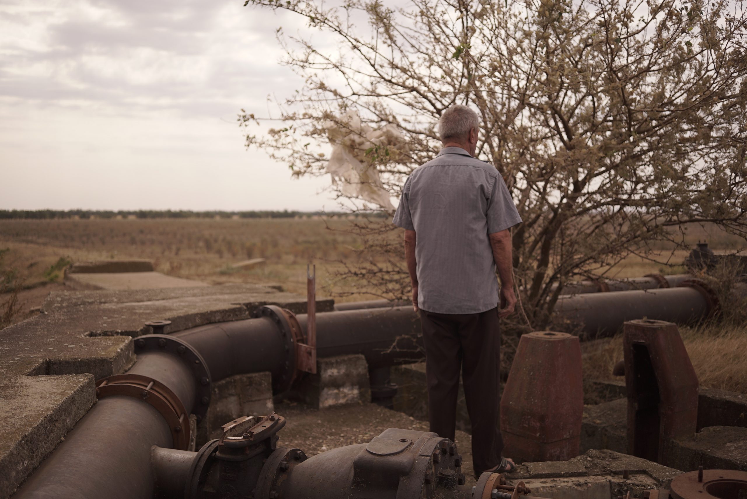
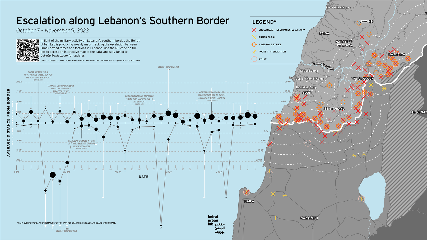
    During communism, extensive irrigation systems turned the regions along the Romanian Plain into major producers of fruit and vegetables. But when the irrigation infrastructure collapsed, so did the ecosystems built around it. Today, farmers are digging wells to deal with desertification: a risky strategy.

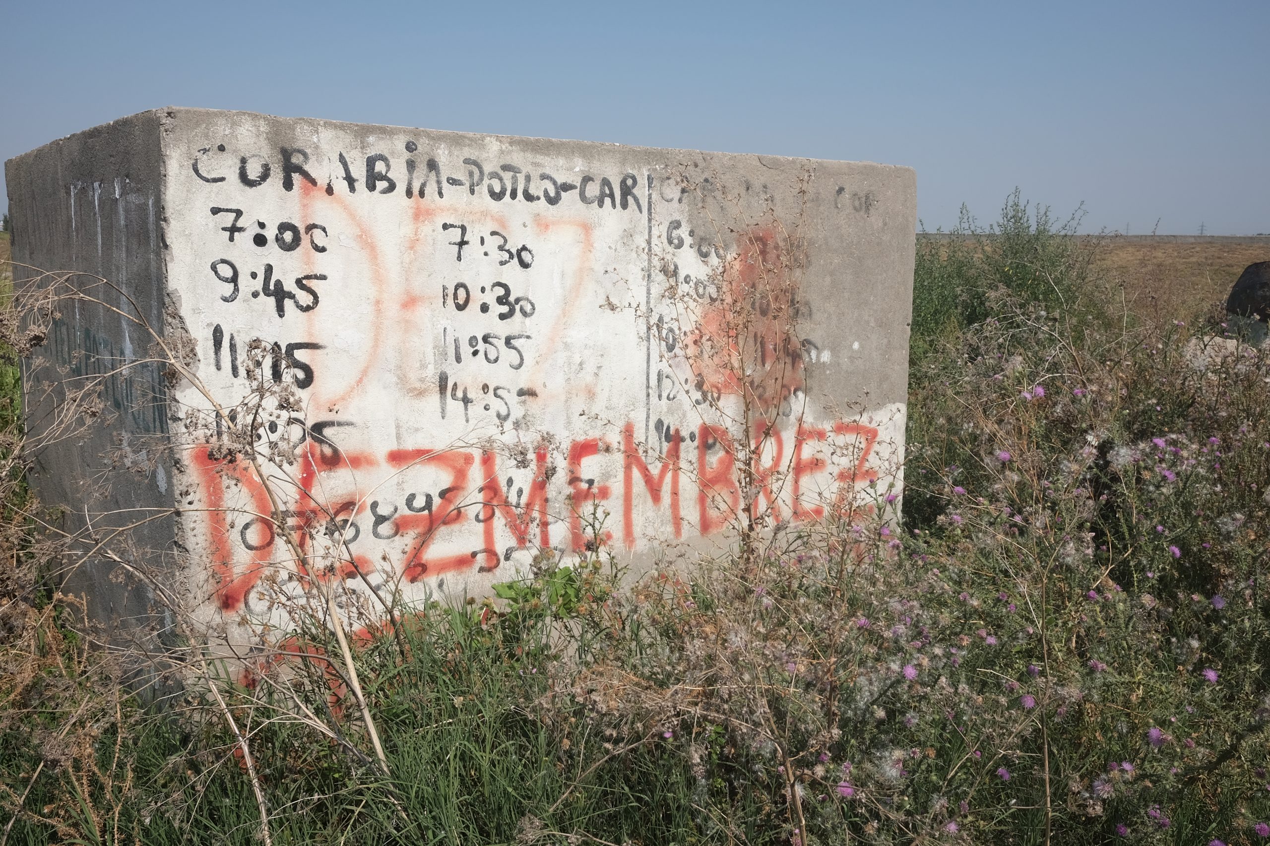
    From the 1970s until 2000, the Sadova-Corabia irrigation system watered over 70,000 hectares of land in Romania’s Dolj and Olt counties. A set of pipelines that brought water from the Danube, the system turned the area from a sandy region predominantly used for vineyards into a fruit and vegetable paradise. Little by little, however, the system was abandoned; now only segments of it are still working.

    Agriculture in the area has changed, as has the environment. Today the Sadova-Corabia region is known not just as the homeland of Romania’s famous Dăbuleni watermelons, but also as the ‘Romanian Sahara’. Together with the south of Moldavia, Dobrogea and the Danubian Plain, it is one of the regions in Romania most affected by desertification.

    Anthropologist Bogdan Iancu has been researching the irrigation system in southern Romania for several years. Scena9 sat down with him to talk about drought, Romania’s communist-era irrigation systems, and the local reconstruction of agriculture after their decline. The interview has been edited for clarity.

    Oana Filip: How did your interest in drought arise?

    Bogdan Iancu: Rather by accident. Around seven years ago I was in the Danube port of Corabia for another research project, and at one point I heard a student talking at a table with a local, who was telling him about the 2005 floods and the irrigation systems in the area. The man also wanted to talk to me and show me the systems. It was an extremely hot summer and I thought it was very interesting to talk about irrigation and drought.

    I myself come from the area of Corabia-Dăbuleni. My grandparents lived in a village a bit north of the Danube floodplains, where there was an irrigation system with canals. This was where I learned to swim. The encounter somehow reactivated a personal story about the frequent droughts of that time and the summers I spent there. A lot of people in the area told us that the emergence of irrigation systems in the ’60s and ’70s led to more employment in agriculture. For them it was a kind of local miracle. As I realized that droughts were becoming more frequent and widespread, I became certain that this could be a research topic.

    The following year I started my own project. In the first two or three years, I was more interested in the infrastructure and its decline, the meanings it held for the locals and the people employed in the irrigation system, and how this involved their perceptions of changes in the local microclimate. Later, I became interested in the fact that people began to migrate out of the area because of the dismantling and privatization of the former collective or state-owned farms.

    I then started looking at how seasonal workers who had left for Italy, Spain, Germany or Great Britain had begun to come back to work in agriculture and start their own small vegetable farms. I was interested in how they started to develop the area, this time thanks to a few wells that have been drilled deep into the ground. So, somehow, the formerly horizontal water supply has now become vertical. This could have some rather unfortunate environmental implications in the future, because too many drilled wells that are not systematically planned can cause substances used in agriculture to spill into the ground water.

    How has the locals’ relationship with water changed with the disappearance of the irrigation system and the increasing frequency of droughts?

    The irrigation system had a hydro-social dimension. Water was primarily linked to agriculture and the planned socialist system. For a long time, the locals saw the system as the reason for the appearance and cultivation of fruits and vegetables they had never known before. For ten years after 1990, the irrigation network still worked and helped people farm on small plots of land, in subsistence agriculture, so that they could still sell vegetables in nearby towns. But after 2000 the state increased the price of water and cut subsidies. When the system collapsed, the ecosystem built around it collapsed along with it.

    At that time, something else was going on as well. The system was being fragmented through a form of – let’s say partial – privatization of the water pumping stations. The irrigators’ associations received loans via the World Bank. These associations did not work very well, especially since the people there had just emerged from the collective farming system, and political elites deliberately caused all forms of collective action to lose credibility after the ’90s.

    Because the irrigation system was no longer being used, or being used at much lower parameters than before, it no longer seemed functional. Bereft of resources, the local population saw the remaining infrastructure as a resource and sold it for scrap. It became even more difficult to use the irrigation system. This caused people to migrate abroad. The first waves of ‘strawberry pickers’ have only recently started coming back, perhaps in the past six or seven years, bringing in the money they have made in Italy or Spain.

    People have to be empowered in relation to the water they need. So these seasonal workers began digging their own wells. They have lost all hope that the state can still provide this water for them. They saw that in the Romanian Danubian Plain, thousands, tens of thousands of hectares of land were sold off cheaply to foreign companies that receive water for free, because they take it from the drainage canals. This caused even greater frustration for the locals, who not only look down on the new technologies that these companies use, but also resent their privilege of receiving free water from the Romanian state.

    How do you see the future of the area?

    It’s difficult to say. In the short term, I think the area will partially develop. But, at the same time, I think problems could arise from too many exploitations.

    The number of private wells will probably increase. Some very large companies in Romania are lobbying Brussels to accept the inclusion of wells drilled into underground aquifers (geological formations that store groundwater) into the irrigation strategy being developed by the Ministry of Agriculture and Rural Development. This would mean ten years of semi-subsistence, or slightly above semi-subsistence agriculture, where the former ‘strawberry pickers’ turn into successful small farmers. We’ve already seen this in the villages on the Sadova-Corabia system. But we have no way of knowing how long this will last, and how much pressure these aquifers would be subjected to. There is a risk that they might get contaminated, because they function like pores, and the water resulting from agricultural activities, which contains nitrites and nitrates, could get in there and cause problems.

    In Spain, for instance, they are very cautious about drilling wells. Arrests have been made. It’s a political issue that contributed to the defeat of Pedro Sanchez’s Socialist party in the last elections. Many farmers in Spain privileged to have access to water could dig a well wherever they wanted, but now found themselves faced with this rather drastic law. And the People’s Party promised them that they would be able to continue digging wells.

    At the Dăbuleni Agricultural Research Station, for example, they are experimenting with exotic crops better adapted to desertification, such as dates, kiwis and a certain type of banana. Do you think people could adopt new cultures in Sadova-Corabia too?

    This already happened decades ago. With the advent of the irrigation system, people were forced to be open to cultivating vegetables and fruits they had never seen before. Someone told me how, when they ate the first eggplants, they didn’t know what to do with them, they seemed bitter. Even tomatoes, which to us seem always to have been eaten there, were only introduced in the ’60s. One person told me that when he first tried a tomato he thought it tasted like soap. But if their grandparents or parents could adapt, so will people today. Besides, most have worked in agriculture abroad with this kind of fruit.

    Have you seen any irrigation best practices that you think would be suitable for the situation in the Sadova-Corabia area?

    I think one such example is micro-agriculture, which is employed on smaller plots in Italy, for instance. There are also micro farms in Sadova-Corabia that produce organic, ecological, sustainable products and so on. And there are a few cooperatives that work quite well, some of them supply tomatoes for the Belgian-owned supermarket chain Mega Image, for example.

    Spain, on the other hand, is not a best practice model. Spain is a devourer of water resources in an absolutely unsustainable way. We’re already seeing that the Tagus (the longest river in the Iberian peninsula and an important source for irrigation) is endangered by large-scale agriculture. In the 1990s, there was small and medium-sized farming there, and I think there should be a return to that. Obviously, the economists say it’s not profitable, but it’s time to think about a decrease and not an increase, which is always cannibalistic. This kind of farming, on a medium or small scale, should also bring this irrigation system back into focus.

    Unfortunately, it’s unclear for how much longer the Sadova-Corabia system will be able to function. It has an outlet in the Danube, which dries up in the summer and is not permanently supplied with water, as it was during the socialist period. Last year, for example, irrigation electricians and mechanics working on the Danube encountered problems, because the main canal poured water into the Danube, instead of collecting from it. If the Danube is no longer a sustainable source for irrigation canals (and not just in Romania), the alternative lies in the different management of water resources.

    In the multimedia exhibition based on the project that you organized last year, there was a notion of how grand socialist projects obfuscated life narratives, and how human stories were lost to anonymity. What life narratives are being lost or hidden now, in this larger discussion of drought and desertification in the area?

    I met a woman who during communism had managed a farm where they grew peaches that were then exported to Germany and Czechoslovakia. She told me that local vegetables were exported to Great Britain; and that this export was even stipulated by the two countries. Over 200 British technicians and experts lived in Sadova-Corabia for about four years. The story of these people, these British experts, not just the Romanian ones, and how they collaborated is completely lost to history.

    In the ’70s, these people were a sort of agricultural vanguard. They were trying to propose a productive model of agriculture, a break from the post-feudal, post-war past. There were people who worked at the pipe factory and built those gigantic pipes through which water was collected from the Danube. Today, there are still people who continue to make enormous efforts to do what needs to be done. The mayor of Urzica, for example, encourages locals to sell or give away plots of land for afforestation, and the town hall is even trying to deploy its own afforestation projects.

    I have seen journalists travel to the area for two days, come back and report that socialism destroyed everything. Obviously, lakes were drained and the environmental toll was very high. At the same time, that era brought unlimited water to many areas where it was previously lacking. Acacia forests were planted. Biologists say they’re no good, as they actually consume water from the soil; but foresters everywhere defend them and say they provide moisture.

    One way or another, all these stories should be told. As should the stories of the people who went abroad for work and are coming back. These so-called ‘strawberry pickers’ or ‘seasonals’, whose lives we know nothing about, because the Romanian state doesn’t believe that five million Romanians who went to work abroad deserve the attention.

    When I went to the Dăbuleni research station, many of the researchers had grown up there and had a personal connection to the area and a notion that they were working for the place where they grew up. How does the connection between the locals and the environment change, when so many choose to work abroad?

    This is where things intersect. These people have parents who tell us that for them the emergence of the irrigation system was similar to what happened in Israel, a country that has problems with its soil and that managed to make it better with the aid of water improvement systems. They saw that desert repopulated, greened, diversified, and they saw a greater complexity in the kinds of crops they can grow. They got predictability, i.e. permanent jobs at state agricultural enterprises, or jobs that allowed them to work at home, at the agricultural production cooperative (CAP).

    One thing I didn’t know before this research was that peasants who met their agricultural production quota were given 22 acres of land that they could work within the CAPs, with fertilizer from the CAPs, and irrigated with water from CAPs. One person I talked to even drove a truck contracted by the state and sold watermelons in Cluj, Sibiu, Râmnicu Vâlcea, and Bucharest in the 1980s and 1990s. And he wasn’t the only one.

    For them, the irrigation system was not only associated with farms, but also the related industries – pipeline factories, factories making tiles that lined the irrigation channels. It was a flourishing new ecosystem. But once this system collapsed, they also came to associate it with the degradation of the environment. I spoke to a local who said that when the system worked, he didn’t feel the summer heat, even though the temperatures were just as high, because of the water in the canal network.

    The absence of water is like the absence of blood – without it, an organism can no longer metabolize. And then, naturally, the young people decided to leave. But this was not a permanent departure. They went to Spain, for example, they saw vertical water there, and they said, ‘Look, we can make our own wells, we don’t need to wait around for horizontal water.’

    Why, as a state, have we failed to come up with an irrigation project today as ambitious as Sadova-Corabia in its time?

    There’s more to it than just this one system. There are about a hundred or so chain irrigation systems that start in this area, from south of Resita all the way to Dobrogea. The problem is that these irrigation systems were in full boom before the 1990s. Now, don’t think I believe that only irrigation systems can ensure good crops. I think they should be seen as part of a mixed bag of solutions. The problem is not that no more irrigation systems have been built, but that the old ones have not been preserved, optimized or modernized. Private interests were prioritized, especially those of a very large class of landowners, and land-grabbing was prioritized to the detriment of working on smaller plots of land. And so, such infrastructures were abandoned, because the big players can afford super-performant extractive technologies.

    How do you see urban dwellers relate to droughts and irrigation?

    I have seen many of them ridiculing people in the countryside and finding it unacceptable that they use municipal water handed to them for irrigation; but, at the same time, none of them disclose the amount of water they use on their lawns, which are worthless grass. Obviously, it’s easier to laugh from inside an office and to think that people are being irrational than to understand that they’re selling tomatoes that they would have otherwise been unable to grow.

    As climate change intensifies, droughts will become more frequent. Will we see better cooperation in the face of this new reality, or more division?

    In the next five to six years I think we will see more competition for water and the criminalization of our fellow water-users. But I think that this is where the role of the media comes in. It should abandon the logic of only showing us the big, scary monster called climate change. Rather, it should detail how these climate changes are occurring at the grassroots level. I think both the press and the state should work on research and popularization, on disseminating information that talks about these effects.

    I don’t think that anything can be done without pedagogies. Yes, during the socialist period these pedagogies were abused, sometimes enforced with actual machine guns, and that was tragic. But today we don’t see any kind of pedagogy, any kind of relating. None of the measures that need to be implemented are socialized. People are not being called to their village cultural center to be told: ‘Here’s what we want to do.’ The cultural center is now only used for weddings. Some radical forms of pedagogy should be devised and disseminated locally, so that people understand the invisible price of water.

    https://www.eurozine.com/the-invisible-price-of-water
    #eau #histoire #communisme #Roumanie #irrigation #infrastructure #agriculture #puits #Dolj #Olt #acqueduc #Danube #maraîchage #vignobles #fruits #Sadova-Corabia #melons #Dăbuleni #désert #désertification #sécheresse #privatisation #banque_mondiale #émigration #saisonniers #fraises #micro-agriculture #Urzica #Bogdan_Iancu
    via @freakonometrics

  • L’aiguille des minutes : Anima Sola #27
    Récit poétique à partir d’images créées par procuration.

    https://liminaire.fr/palimpseste/article/l-aiguille-des-minutes

    Dès qu’il se met à pleuvoir, on cherche un abri, un sas de décompression, un refuge temporaire. Une parenthèse. On ne sait pas pour combien de temps on risque de se trouver coincé là. C’est cette incertitude qui nous intrigue en même temps qu’elle nous terrifie. Un temps qui ne sert à rien, qui tourne sur lui-même. Un moment d’observation désœuvrée, un peu lasse, distante. Instant de solitude, de retrait, de retour forcé sur soi.

    (...) #Écriture, #Langage, #Poésie, #Lecture, #Photographie, #Littérature, #Art, #AI, #IntelligenceArtificielle, #Dalle-e, #Récit, #Nature, #Nuit, #Paysage, #Lumière, #Pluie, #Ville (...)

    https://liminaire.fr/IMG/mp4/anima_sola_27.mp4

  • Guerre au Proche-Orient : à #Beyrouth, #Mona_Fawaz résiste par la #cartographie

    Professeure d’urbanisme et cofondatrice du #Beirut_Urban_Lab, la chercheuse cartographie le conflit à la frontière entre le #Liban et Israël. Et montre ainsi le « déséquilibre profond » entre les attaques visant le territoire libanais et celles ciblant le sol israélien.

    « Je suis entrée dans le centre de recherche ; tous mes collègues avaient les yeux rivés sur les nouvelles, l’air horrifié. C’est là que nous nous sommes dit que nous ne pouvions pas simplement regarder : il fallait agir, et le faire du mieux possible », se rappelle Mona Fawaz, professeure d’urbanisme à l’Université américaine de Beyrouth (AUB) et cofondatrice du Beirut Urban Lab, un laboratoire de recherche interdisciplinaire créé en 2018 et spécialisé dans les questions d’#urbanisme et d’#inclusivité.

    Lundi 4 décembre, dans ce centre de recherche logé à l’AUB, près de deux mois après l’attaque sans précédent du groupe militant palestinien Hamas en Israël et le début des bombardements intensifs de l’armée israélienne sur la bande de Gaza, elle revoit l’élan impérieux qui a alors saisi ses collègues du Beirut Urban Lab, celui de cartographier, documenter et analyser.

    « Certains ont commencé à cartographier les dommages à #Gaza à partir de #photographies_aériennes. Personnellement, j’étais intéressée par la dimension régionale du conflit, afin de montrer comment le projet colonial israélien a déstabilisé l’ensemble de la zone », y compris le Liban.

    La frontière sud du pays est en effet le théâtre d’affrontements violents depuis le 8 octobre entre #Israël et des groupes alliés au #Hamas emmenés par le #Hezbollah, une puissante milice soutenue par l’#Iran. Qualifiés de « #front_de_pression » par le chef du Hezbollah, Hassan Nasrallah, les #combats sur le #front_libanais, qui visent notamment à détourner l’effort militaire israélien contre Gaza, ont tué au moins 107 personnes du côté libanais, dont 14 civils. Du côté israélien, six soldats et trois civils ont été tués.

    C’est ainsi que l’initiative « Cartographier l’escalade de violence à la frontière sud du Liban » est née. Le projet répertorie le nombre de #frappes quotidiennes et leur distance moyenne par rapport à la frontière depuis le début du conflit, en s’appuyant sur les données collectées par l’ONG Armed Conflict Location & Event Data Project (Acled : https://acleddata.com). Sur son écran d’ordinateur, Mona Fawaz montre une #carte_interactive, une des seules en son genre, qui révèle un déséquilibre saisissant entre les attaques revendiquées par Israël, au nombre de 985 depuis le début du conflit, et celles menées depuis le Liban : 270 frappes répertoriées sur le sol israélien.

    L’occasion pour Mona Fawaz de questionner les expressions répétées dans les médias, qui façonnent la compréhension du conflit sans remettre en cause leurs présupposés. « On parle de tirs transfrontaliers, par exemple, alors même qu’il y a un déséquilibre profond entre les deux parties impliquées », souligne-t-elle. « Une distorsion médiatique » que la chercheuse dénonce aussi dans la couverture de l’offensive israélienne contre l’enclave palestinienne.

    Une « lutte partagée » avec les Palestiniens

    Pour Mona Fawaz, il est important de documenter un conflit dont les racines vont au-delà des affrontements présents. « La création de l’État d’Israël en 1948 a provoqué une perturbation majeure au sud du Liban, brisant [ses] liens historiques, sociaux, politiques et économiques » avec la Galilée, explique-t-elle.

    Des bouleversements que la chercheuse, originaire du village de Tibnine, dans le sud du pays, connaît bien, puisqu’ils ont marqué son histoire familiale et personnelle. Elle explique que la proximité entre les populations était telle qu’au cours de la « #Nakba » (la « catastrophe », en arabe) en 1948 – l’exode massif de plus de 700 000 Palestinien·nes après la création de l’État d’Israël –, sa mère a été évacuée de son village aux côtés de Palestinien·nes chassés de leurs terres. « Les déplacés ne savaient pas où s’arrêteraient les Israéliens, raconte-t-elle. Dans cette région du Liban, on a grandi sans sentir de différences avec les Palestiniens : il y a une lutte partagée entre nous. »

    En 1982, Mona Fawaz, qui avait alors à peine 9 ans, vit plusieurs mois dans son village sous l’occupation de l’armée israélienne, qui a envahi le pays en pleine guerre civile (1975-1990) afin de chasser du Liban l’Organisation de libération de la Palestine (OLP). Elle se souvient des scènes d’#humiliation, des crosses des fusils israéliens défonçant le mobilier chez son grand-père. « Ce n’est rien par rapport à ce que Gaza vit, mais il y a définitivement un effet d’association pour moi avec cette période », explique-t-elle.

    Dans le petit pays multiconfessionnel et extrêmement polarisé qu’est le Liban, l’expérience de la chercheuse n’est cependant pas générale. Si une partie des Libanais·es, notamment dans le sud, est marquée par la mémoire des guerres contre Israël et de l’occupation encore relativement récente de la région – les troupes israéliennes se sont retirées en 2000 du Sud-Liban –, une autre maintient une défiance tenace contre la #résistance_palestinienne au Liban, notamment tenue responsable de la guerre civile.

    Celle qui a ensuite étudié au Massachusetts Institute of Technology (MIT), à Boston (États-Unis), pour y faire son doctorat en aménagement urbain à la fin des années 1990, explique ensuite qu’il a fallu des années aux États-Unis pour réaliser que « même le soldat qui est entré dans notre maison avait été conditionné pour commettre des atrocités ». Si l’ouverture à d’autres réalités est une étape indispensable pour construire la paix, c’est aussi un « luxe », reconnaît la chercheuse, qui semble hors de portée aujourd’hui. « L’horreur des massacres à Gaza a clos toute possibilité d’un avenir juste et pacifique », soupire-t-elle.

    Le tournant de la guerre de 2006

    Peu après son retour au Liban en 2004, Mona Fawaz se concentre sur les questions de l’informalité et de la justice sociale. Un événement majeur vient bouleverser ses recherches : le conflit israélo-libanais de 2006. Les combats entre Israël et le Hezbollah ont causé la mort de plus de 1 200 personnes du côté libanais, principalement des civil·es, en seulement un mois de combat.

    Du côté israélien, plus de 160 personnes, principalement des militaires, ont été tuées. Cette guerre va être une expérience fondatrice pour le Beirut Urban Lab. C’est à ce moment que ses quatre cofondateurs, Mona Fawaz, Ahmad Gharbieh, Howayda Al-Harithy et Mona Harb, chercheurs et chercheuses à l’AUB, commencent leurs premières collaborations sur une série de projets visant à analyser l’#impact de la guerre. L’initiative actuelle de cartographie s’inscrit en continuité directe avec les cartes quotidiennes produites notamment par #Ahmad_Gharbieh en 2006. « Le but était de rendre visible au monde entier le caractère asymétrique et violent des attaques israéliennes contre le Liban », explique Mona Fawaz.

    Dans les années qui suivent, les chercheurs participent à plusieurs projets en commun, notamment sur la militarisation de l’#espace_public, le rôle des réfugié·es en tant que créateurs de la ville ou la #privatisation des #biens_publics_urbains, avec pour objectif de faire de la « donnée un bien public », explique Mona Fawaz, dans un « pays où la collectivité n’existe pas ». « Nos recherches s’inscrivent toujours en réponse à la réalité dans laquelle nous vivons », ajoute-t-elle. Une réalité qui, aujourd’hui dans la région, est de nouveau envahie par la guerre et les destructions.

    https://www.mediapart.fr/journal/international/121223/guerre-au-proche-orient-beyrouth-mona-fawaz-resiste-par-la-cartographie

    #résistance

    ping @visionscarto @reka

    • #Beirut_Urban_Lab

      The Beirut Urban Lab is a collaborative and interdisciplinary research space. The Lab produces scholarship on urbanization by documenting and analyzing ongoing transformation processes in Lebanon and its region’s natural and built environments. It intervenes as an interlocutor and contributor to academic debates about historical and contemporary urbanization from its position in the Global South. We work towards materializing our vision of an ecosystem of change empowered by critical inquiry and engaged research, and driven by committed urban citizens and collectives aspiring to just, inclusive, and viable cities.

      https://beiruturbanlab.com

      –—

      Mapping Escalation Along Lebanon’s Southern Border Since October 7

      Since October 7, the Middle East has occupied center stage in global media attention. Already rife with uncertainty, subjected to episodic bouts of violence, and severely affected by an ongoing project of ethnic cleansing for 75 years in Historic Palestine, our region is again bearing the weight of global, regional, and local violence. As we witness genocide unfolding and forceful population transfers in Gaza, along with an intensification of settler attacks in the West Bank and Jerusalem and the silencing of Palestinians everywhere, the conflict is also taking critical regional dimensions.

      As part of its effort to contribute to more just tomorrows through the production and dissemination of knowledge, the Beirut Urban Lab is producing a series of maps that document and provide analytical insights to the unfolding events. Our first intervention comes at a time in which bombs are raining on South Lebanon. Titled Escalation along Lebanon’s Southern Border since October 7, the platform monitors military activity between the Israeli Armed Forces and Lebanese factions. Two indicators reflect the varying intensity of the conflict: the number of daily strikes and the average distance of strikes from the border.

      The map uses data from the Armed Conflict Location and Event Data (ACLED) crisis mapping project, which draws upon local reporting to build its dataset. Since ACLED updates their dataset on Mondays, site visitors can expect updates to our mapping and analysis to be released on Tuesday afternoons. Please refer to ACLED’s methodology for questions about data sources and collection.

      As of November 14, the frequency and distribution of strikes reveals a clear asymmetry, with northward aggression far outweighing strikes by Lebanese factions. The dataset also indicates a clear escalation, with the number of incidents increasing day by day, particularly on the Lebanese side of the border.

      We see this contribution as an extension of our previous experiences in mapping conflicts in Lebanon and the region, specifically the 2006 Israeli assault on Lebanon.

      https://beiruturbanlab.com/en/Details/1958/escalation-along-lebanon%E2%80%99s-southern-border-since-october-7
      #cartographie_radicale #cartographie_critique #visualisationi

  • Je connais depuis toujours cette célèbre image de Paris, la carte postale du bouquiniste à la pipe avec au fond Notre Dame. [EDIT] D’autant plus que ce photographe était un proche. Il se faisait parfois enfermé dans la cathédrale pour capter les premières lueurs de l’aube sur Paris.
    C’était un fou de Paris, il s’appelait Pierre Yves Petit (1886-1969) et signait Yvon, au début en grattant la plaque de verre avec une plume, il a été un des premiers photographes éditeurs de cartes postales, tu sais, ces images que l’on s’envoyait par la poste quand on faisait du tourisme et que les appareils photos n’étaient pas encore dans nos téléphones de poche.

    petit hommage aux souris déglinguées autant que les bouquinistes par la politique olympique préfectorale, salut papy !

    Et je vois en publiant ici qu’internet s’approprie aussi cette image, comme la préfecture celle de Paris, je laisse la honte de ce sens unique rouge et injuste, c’est tout à fait représentatif de ce que je voulais dénoncer.

  • Un mélange de faux souvenirs : Anima Sola #26
    Récit poétique à partir d’images créées par procuration.

    https://liminaire.fr/palimpseste/article/un-melange-de-faux-souvenirs

    Je confonds un mélange de faux souvenirs, d’erreurs. Je suis comme tout le monde. Je ferme les yeux. J’imagine que les visages vont naître de l’instant. Je rêve d’un homme qui habite sur une petite île. Je découvre les limites de son monde. Linguiste il est obligé d’abandonner sa femme pour son travail. Il part vivre à l’autre bout du monde pour sauver une langue qui risque de disparaître. Il partage la vie du dernier locuteur, un vieil homme fatigué. Il en profite pour noter toutes ses paroles, ses expressions, il échange avec lui pour apprendre sa langue, tout en élaborant parallèlement un dictionnaire et une méthode d’apprentissage.

    (...) #Écriture, #Langage, #Poésie, #Lecture, #Photographie, #Littérature, #Art, #AI, #IntelligenceArtificielle, #Dalle-e, #Récit, #Nature, #Nuit, #Paysage, #Lumière, #Rêve, (...)

    https://liminaire.fr/IMG/mp4/anima_sola_26.mp4

  • Fabulations de l’enfance : Anima Sola #25
    Récit poétique à partir d’images créées par procuration.

    https://liminaire.fr/palimpseste/article/fabulations-de-l-enfance

    C’est une image d’enfance, une image qui revient me hanter régulièrement. Je suis seule, égarée en chemin dans un paysage que je ne reconnais plus, un lieu qui me devient étranger, sans doute à cause de la faible lumière. La nuit tombe, il fait froid. Le vent souffle et fait trembler les arbres. Leurs longues branches nues se balancent dans l’air gris du soir, et leurs bruits me glacent d’effroi. J’avance pour ne pas rester sans rien faire, immobile, en danger, exposée dans ce paysage désolé. Il va faire bientôt nuit.

    (...) #Écriture, #Langage, #Poésie, #Lecture, #Photographie, #Littérature, #Art, #AI, #IntelligenceArtificielle, #Dalle-e, #Récit, #Nature, #Nuit, #Corps, #Lumière (...)

    https://liminaire.fr/IMG/mp4/anima_sola_25.mp4

  • Sur le visage comme un oubli : Anima Sola #24
    Récit poétique à partir d’images créées par procuration.

    https://liminaire.fr/palimpseste/article/sur-le-visage-comme-un-oubli

    La nuit est tombée. J’admets que ce doit être bien difficile de tout prévoir à l’avance. La pluie continue à tomber, les gouttes d’eau ricochent sur la surface translucide de mon parapluie. Je vois leurs ondes se former au sol, tandis que les lumières de la rue sont éclaboussées dans les flaques par leurs reflets. J’arrive à un carrefour, je cherche ma direction. Et soudain, un son tremblotant m’interrompt. C’est une voix frêle que j’entends dans le tumulte de la circulation nocturne. Une voix privée de toute signification qui prononce des paroles incompréhensibles. Une voix sans âge ni sexe qui vient de loin.

    (...) #Écriture, #Langage, #Poésie, #Lecture, #Photographie, #Littérature, #Art, #AI, #IntelligenceArtificielle, #Dalle-e, #Récit, #Portrait, #Corps, #Lumière, #Pluie (...)

    https://liminaire.fr/IMG/mp4/anima_sola_24.mp4

  • Des coïncidences visibles : Anima Sola #23
    Récit poétique à partir d’images créées par procuration.

    https://liminaire.fr/palimpseste/article/des-coincidences-visibles

    Les formes se confondent avec les signes. Je cherche les liaisons, comment les rétablir. Une sensation ancienne, le souvenir d’une caresse pressante sur mon bras. La pression de ses doigts. Les traces blanches à la surface de ma peau qui s’effacent très vite après avoir desserré leur étreinte. Leur bref surgissement rappellent ces corps célestes qui traversent le ciel la nuit et qui, malgré la brièveté de leur passage, sont d’une nature éternelle, car ils forment le tissu du monde.

    (...) #Écriture, #Langage, #Poésie, #Lecture, #Photographie, #Littérature, #Art, #AI, #IntelligenceArtificielle, #Dalle-e, #Récit, #Portrait, #Corps, #Lumière, #Paysage (...)

    https://liminaire.fr/IMG/mp4/anima_sola_23.mp4

  • A New Tool Allows Researchers to Track Damage in #Gaza

    As the Israel Defense Forces (IDF) continue to bomb the Gaza Strip, many researchers are attempting to track and quantify the damage to the territory’s buildings, infrastructure and the displacement of the local population.

    A new tool, originally developed to estimate damage in Ukraine, has now been adapted and applied to Gaza. The tool can estimate the number of damaged buildings and the pre-war population in a given area within the Gaza Strip.

    The tool has already been used by a number of media outlets, but it is freely available for anyone to use and we have outlined its key features below.

    The coloured overlay on this map is a damage proxy map indicating the probability of a significant change occurring at particular locations since October 10, 2023. Users can click the “draw polygon” button to draw an area of interest on the map — for example, a particular neighbourhood.

    To understand how the tool works, let’s look at the neighbourhood of Izbat Beit Hanoun, which sustained heavy damage visible in these high-resolution, before-and-after satellite images from Planet:

    The row of apartment complexes in the north of the neighbourhood near the road has been razed. Lower-density areas in the centre and northeast of the neighbourhood have also sustained heavy damage. Airstrikes have also destroyed several of the apartment complexes in the southwest.

    Below is the damage probability map generated by the tool, highlighting many of these areas:

    Drawing a box over this neighbourhood allows us to roughly quantify the number of buildings – and people- affected by the destruction.

    In the neighbourhood of Izbat Beit Hanoun, the tool estimates that there are 321-425 damaged buildings (73 — 97%), displayed with colours above. The tool also estimates that in the area of interest there was a pre-war population of 7,453, of which 4756 – 6304 lived in areas that are now likely to be damaged.
    How it Works

    Synthetic Aperture Radar (SAR) imagery has been used extensively in academic studies of building damage, and by groups like NASA following the 2020 explosion at the port of Beirut. NASA explains the use of SAR for building damage detection as follows: “SAR instruments send pulses of microwaves toward Earth’s surface and listen for the reflections of those waves. The radar waves can penetrate cloud cover, vegetation, and the dark of night to detect changes that might not show up in visible light imagery. […] When buildings have been damaged or toppled, the amplitude and phase of radar wave reflections changes in those areas and indicate to the satellite that something on the ground has changed.”

    The application above detects damaged areas by measuring the change in the intensity of the radar waves reflected back to the Sentinel-1 satellite before and after October 10, 2023, adjusted for how noisy the signal is in both periods. A more detailed explanation of the algorithm (which was peer-reviewed for a conference) is available here, and a walkthrough (including code) applied to the 2020 Beirut explosion is available here.

    Once likely damaged areas have been identified, the damage probability map is combined with building footprints from Microsoft. Footprints in which significant change has occurred are classified as damaged. This yields a count (and proportion) of estimated damaged buildings within an area.

    To get a rough idea of the number of people affected in a given area, population data are sourced from the LandScan program at Oak Ridge National Laboratory. The data are provided at the level of 90 metres. These population estimates are generated by merging current data on building structures, occupancy rates and infrastructure. Because these are estimates, they are subject to some level of error. They also predate the current conflict and are thus not meant to be interpreted as a count of actual or potential civilian casualties. You can read more about LandScan data here.
    Accuracy

    To assess the accuracy of the damage detection algorithm, damage points from the UN Satellite Office (UNOSAT) were used for validation. These are generated by manually combing through high-resolution satellite imagery and tagging visibly damaged buildings. Below is the same image of Izbat Beit Hanoun, with UNOSAT damage points overlaid in white.

    In the images above, the colourful overlay is a damage probability map. Darker colours indicate a higher probability that a significant change occurred after October 10, 2023.

    The UNOSAT damage points are available under the “Layers” tab in the top right corner of the tool. It should be noted that UNOSAT carried out the assessment on November 7 and that damage has occurred since then.

    Geolocated Footage

    To get an additional source of validation data, geolocated footage of strikes and destruction in Gaza are available under the “Layers” tab in the top right, and are displayed as blue triangles.

    These are sourced from Geoconfirmed, a community-based geolocating network. Clicking on a geolocated event will open a panel in the top right, showing a brief description of the event, the date, a link to the source media, and a link to the geolocation of the event.

    In the example below, clicking on a geolocated event in the heavily damaged Tal al-Hawa neighbourhood reveals that Gaza City’s International Eye Hospital appears to have been hit by an airstrike.

    Clicking on “Source Media” shows the following image of the eye hospital.

    Clicking on “Geolocation” displays the following tweet, which uses the visible characteristics of the building itself and adjacent buildings to locate the picture.

    Further research confirms that the International Eye Hospital was subsequently completely destroyed.

    It should be noted that the geolocations have not been independently verified by the creators of the tool and are automatically added to the map as they become available. Nevertheless, these geolocations are an important additional source of preliminary information. As of the date of publication, there were 541 geolocated events in the Gaza Strip. The tool automatically adds new geolocations as they become available.
    Important Caveats

    While this tool can help us better understand the devastating impact of IDF strikes on Gaza, there are a number of important caveats to bear in mind when using it.

    The first is that this tool detects any significant changes that have occurred in Gaza since October 10, 2023. The vast majority of these changes are likely related to conflict damage, but not all. For example, placing a large number of tents on a previously open field would be detected, since this would change the amplitude of the signal reflected back to the Sentinel-1 satellite from that patch of land.

    Second, because of the way the algorithm functions, older damage will be more confidently detected than newer damage. Thus, while the tool updates automatically as new imagery becomes available, it may take some time for newer damage to become visible. Other SAR-based methods can produce accurate estimates of damaged areas on a particular date. The Decentralized Damage Monitoring Group is working on such methodologies, with the aim of publicly disseminating damage maps that show not only where damage has occurred, but when.

    Finally, the assessment of population exposure is not a measure of actual or potential civilian casualties. These population estimates predate the most recent conflict in Gaza, and many civilians have fled. The affected population counts represent a ballpark estimate of the number of people who previously lived in areas that are now likely damaged or destroyed.
    Accessing the Tool

    The Gaza Damage Proxy Map uses previously established and tested methodology to provide estimates of damage to buildings. The data is updated approximately one to two times per week as new satellite imagery is gathered by the Sentinel-1 satellite. It therefore represents cumulative damage since October 10, not real-time damage to buildings.

    Although the information provided by the tool is an estimate, it is useful for researchers to quickly gain an overview of damaged areas in the Gaza Strip.

    You can access the Gaza Damage Proxy Map here.

    A similar tool using the same methodology to assess damage in Ukraine following Russia’s full-scale invasion and in Turkey following the February 6 Turkey-Syria earthquake, can be accessed here: https://ee-ollielballinger.projects.earthengine.app/view/gazadamage

    https://www.bellingcat.com/resources/2023/11/15/a-new-tool-allows-researchers-to-track-damage-in-gaza

    #imagerie #architecture_forensique #destruction #cartogrphie #visualisation #guerre #images_satellites #images_satellitaires #Synthetic_Aperture_Radar (#SAR) #UNOSAT #géolocalisation #photographie #dégâts #bombardements

    ping @visionscarto

  • Life on the streets of Los Angeles – in pictures
    https://www.theguardian.com/culture/gallery/2023/nov/15/life-on-the-streets-of-los-angeles-in-pictures

    The photographer and campaigner Suitcase Joe is known for his raw depiction of life on Skid Row. His new book, Grey Flowers, takes an unflinching but empathic look at working-class, unhoused and marginalised people in the city

    #photographie
    #solitude


    Naked and Alone in Skid Row
    A pregnant woman walks naked and alone through the heart of Skid Row, clutching a blanket. When asked if she needed some clothes and warned of the attention she might bringing to herself, she replied: ‘What can they do to me now that they haven’t already done?’

  • L’art de l’indécis
    https://laviedesidees.fr/Pauline-Martin-Le-flou-et-la-photographie

    Il ne faut pas opposer la netteté et le flou, comme si ce dernier n’était défaut technique ou absence de maîtrise. L’histoire de la #photographie montre qu’il a au contraire fait l’objet d’une élaboration minutieuse. À propos de : Pauline Martin, Le flou et la photographie, histoire d’une rencontre (1676-1985), Presses universitaires de Rennes

    #Arts #peinture #beaux-arts
    https://laviedesidees.fr/IMG/pdf/20231107_flou.pdf
    https://laviedesidees.fr/IMG/docx/20231107_flou.docx

  • Sous la lumière : Anima Sola #22
    Récit poétique à partir d’images créées par procuration.

    https://liminaire.fr/palimpseste/article/sous-la-lumiere

    J’observe les vagues se briser sur la coque du navire, leur écume blanche et leur bruit mat. Dans cette effervescence brumeuse, je vois des images qui se succèdent rapidement sous mes yeux sans que je les vois réellement. Ce sont des images mentales. La route entourée de palmiers se détache dans le contrejour de la lumière. Les filets des bateaux de pêche accostés au port qui chaloupent et se balancent au gré des courants. Mais très vite, ces images se troublent, leurs formes se mêlent les unes aux autres. Je ne vois plus rien. Ce sont des paroles qui s’imposent à moi.

    (...) #Écriture, #Langage, #Poésie, #Lecture, #Photographie, #Littérature, #Art, #AI, #IntelligenceArtificielle, #Dalle-e, #Récit, #Portrait, #Corps, #Lumière, #Mer (...)

    https://liminaire.fr/IMG/mp4/anima_sola_22.mp4

  • Female faces of photography : masterworks at Paris Photo – in pictures
    Helen Levitt : New York, 1971

    One of the most influential street photographers of the 20th Century, #Helen_Levitt spent decades documenting local communities in her native city, capturing everyday city life in neighbourhoods such as the Lower East Side, Bronx and Spanish Harlem


    Photograph : Helen Levitt/Courtesy Galerie Thomas Zander, Cologne
    #photographie