Seenthis
•
 
Identifiants personnels
  • [mot de passe oublié ?]

 
  • #p
  • #pla
  • #plan
  • #planification
RSS: #planification_urbaine

#planification_urbaine

  • #planification_urbaine_féministe
0 | 25
  • @topophile
    Revue Topophile @topophile via RSS 20/01/2025
    1
    @reka
    1

    « Mamífera » : et si l’espace public facilitait l’allaitement ?
    ▻https://topophile.net/savoir/mamifera-et-si-lespace-public-facilitait-lallaitement

    https://topophile.net/wp-content/uploads/2025/01/Equal-Saree-Mamifera-Verde02-F.-Conchi-Berenguer-Urrutia-Topophile.jpg

    En 2023, alors que le festival MODEL - Festival d’Arquitectures de Barcelona, proposait de s’intéresser à l’idée d’« empathie radicale », les membres d’Equal Saree ont imaginé un pavillon d’allaitement collectif intitulé Mamífera. Composée d’architectes et de chercheuses, cette agence interroge la conception de nos espaces publics et la place qui y est faite au soin, aux... Voir l’article

    Revue Topophile @topophile via RSS
    • @reka
      Phil Reka docs & archives @reka CC BY-NC-SA 20/01/2025

      #urban_matter
      #aménagement_urbain
      #urban_planning
      #planification_urbaine

      Phil Reka docs & archives @reka CC BY-NC-SA
    Écrire un commentaire
  • @metropolitiques
    Metropolitiques @metropolitiques via RSS 9/09/2024
    4
    @reka
    @simplicissimus
    @colporteur
    @stephane_m
    4

    À la recherche du #polycentrisme francilien
    ▻https://metropolitiques.eu/A-la-recherche-du-polycentrisme-francilien.html

    Et si la révision du Schéma directeur d’aménagement de la région #Île-de-France (SDRIF-E) faisait fausse route ? Jacqueline Lorthiois et Harm Smit appellent à un véritable polycentrisme, fondé sur la superposition des bassins d’emploi et des bassins de vie afin de réduire les temps de transport et les #inégalités entre territoires franciliens. L’objectif du schéma directeur de la Région Île-de-France (SDRIF) est de définir « la planification stratégique afin d’encadrer la croissance urbaine, l’utilisation de #Débats

    / #planification_urbaine, inégalités, #emploi, Île-de-France, #transports, centralité, polycentrisme, (...)

    #centralité #mobilité
    ▻https://metropolitiques.eu/IMG/pdf/smit-lorthiois.pdf

    Metropolitiques @metropolitiques via RSS
    Écrire un commentaire
  • @cdb_77
    CDB_77 @cdb_77 3/03/2024
    1
    @freakonometrics
    1

    Nos villes sont des oeufs au plat ? L’#urbanisme expliqué par une omelette

    https://pixelfed.zoo-logique.org/storage/m/_v2/578583396227231930/062ac74bd-fb82c6/T7Nwlz9qyxaH/GDlvXZRpbanv4REIeA7gHg442SS1BOUa00pEktTE.png

    Je me permets de vous signaler la parution d’une nouvelle vidéo sur ma chaîne de vulgarisation en géographie « Archipel ».
    Elle tente d’expliquer l’histoire des villes et les grands principes de l’urbanisme avec… des œufs.

    ▻https://www.youtube.com/watch?app=desktop&v=CQm0aCrluy8


    #villes #histoire_des_villes #urban_matter #ressources_pédagogiques #vidéo #oeuf #oeufs #fonctions #lieu_De_pouvoir #concentration_des_richesses #fortifications #Antiquité #Empire_romain #Moyen-Age #fonction_politique #fonction_religieuse #fonction_commerciale #révolution_industrielle #industrialisation #exode_rural #quartiers_industriels #pouvoir #modernité #ville_moderne #voiture #pavillons #périurbain #étalement_urbain #maisons_individuelles #junkspace #rural #artificialisation_des_sols #étapes #Banham #Le_Corbusier #zonage_urbain #planification_urbaine #usage_des_sols #covid #post-covid #télétravail #polycentrisme #moncentrisme #liens_sociaux #aménagement_urbain #chronourbanisme #chrono-urbanisme #Cedric_Price

    CDB_77 @cdb_77
    Écrire un commentaire
  • @urban_political
    Urban Political @urban_political via RSS 1/09/2023
    4
    @cdb_77
    @reka
    @colporteur
    @hassan_nya
    4

    Book Review Roundtable: Against the Commons: A Radical History of Urban Planning
    ▻https://urbanpolitical.podigee.io/68-against-the-commons

    Against the Commons underscores how urbanization shapes the social fabric of places and territories, lending awareness to the impact of planning and design initiatives on working-class communities and popular strata. Projecting history into the future, it outlines an alternative vision for a postcapitalist urban planning, one in which the structure of collective spaces is defined by the people who inhabit them.

    #Commons,Commoning,Radical_Planning,Berlin,Enclosure,Agrarian_Question,Milan,New_York,Chicago
    ▻https://audio.podigee-cdn.net/1204327-m-7c57eda7252ce5d46d0d1f7cea9d8acc.m4a?source=feed

    Urban Political @urban_political via RSS
    • @cdb_77
      CDB_77 @cdb_77 1/09/2023

      Against the Commons. A Radical History of Urban Planning

      https://m.media-amazon.com/images/P/1517911761.01._SCLZZZZZZZ_SX500_.jpg

      An alternative history of capitalist urbanization through the lens of the commons

      Against the Commons underscores how urbanization shapes the social fabric of places and territories, lending awareness to the impact of planning and design initiatives on working-class communities and popular strata. Projecting history into the future, it outlines an alternative vision for a postcapitalist urban planning, one in which the structure of collective spaces is defined by the people who inhabit them.

      ▻https://www.upress.umn.edu/book-division/books/against-the-commons
      #livre #communs #planification_urbaine #urbanisme #capitalisme #post-capitalisme

      CDB_77 @cdb_77
    Écrire un commentaire
  • @cdb_77
    CDB_77 @cdb_77 28/10/2022
    1
    @monolecte
    1

    #Glasgow becomes UK’s first city to adopt feminist town planning approach

    https://i.imgur.com/QNXdgyY.png

    SCOTLAND’S biggest city has become the first in the UK to back a “#feminist_town-planning” strategy.

    Councillors in Glasgow have backed a motion which called on the council to ensure the needs of women are put at the centre of how planning decisions on roads, parks and new buildings are made.

    It could see new rules introduced requiring new pavements to be wide enough to accommodate buggies or for parks to be brightly lit at night.

    Greens councillor Holly Bruce put forward the motion which was backed by a majority of the local authority on Thursday.

    She said that traditional town planning rules did not adequately cater to the needs of women.

    Her motion called on the council to make the needs of women central to “all aspects of planning, public realm design, policy development and budgets”.

    Bruce added: “Women, and those of marginalised genders, have a right to the city, have a right to not only to exist but to flourish in its environment.

    “I’m delighted that our motion received unanimous support from across the chamber today and it’s so exciting to consider how much better Glasgow can become with a feminist approach to designing our city.

    “For too long, our streets, parks and buildings have been designed by men. The apparently ‘gender-neutral’ approach that we’ve used for centuries has meant that the male perspective has become the default.

    "These shortcomings have often been unintended, and are an obvious consequence of having too few women in the rooms where decisions are made.”

    ▻https://www.thenational.scot/news/23083380.glasgow-becomes-uks-first-city-adopt-feminist-town-planning-a

    #féminisme #villes #Holly_Bruce #planification_urbaine_féministe #femmes #droit_à_la_ville
    #TRUST #master_TRUST

    CDB_77 @cdb_77
    Écrire un commentaire
  • @cdb_77
    CDB_77 @cdb_77 12/04/2021
    2
    @monolecte
    @colporteur
    2

    La città post-pandemica non potrà esistere senza giustizia sociale e spaziale

    Dove eravamo arrivati

    Parlare oggi di rigenerazione urbana e innovazione sociale non può avere lo stesso significato di qualche mese fa. È chiaro come l’emergenza pandemica lascerà un segno sia sulla capacità delle comunità urbane di attivarsi, sia sulla possibilità delle istituzioni di sostenerle.

    La letteratura sull’innovazione sociale sottolinea da tempo come le forme di innovazione sociale si attivino soprattutto in aree urbane a forte capitale sociale e che abbiano già sperimentato forme di attivazione dal basso; troviamo inoltre innovazione sociale soprattutto in quelle aree urbane capaci di favorire spazi di relazione caratterizzati da diversità sociale e culturale. Esiste quindi una relazione problematica tra innovazione sociale e diseguaglianze urbane.

    Le ricerche condotte in questi anni hanno inoltre dimostrato che l’innovazione sociale ha un forte bisogno di spazio e delle istituzioni per potersi ancorare e definire progettualità durature nel tempo e potenzialmente inclusive.
    Quali cambiamenti

    Capitale sociale, spazi in disuso, presenza delle istituzioni. L’emergenza pandemica avrà sicuramente un impatto su come questi 3 “ingredienti” dell’innovazione sociale si comporranno nei territori.

    Ci troveremo probabilmente di fronte ad una città mutata, dove le diseguaglianze sono destinate ad aumentare con un impatto su come il capitale sociale e la presenza di vuoti urbani saranno distribuiti nello spazio. Ci troveremo presumibilmente di fronte ad un aumento della dotazione di spazi vuoti, in maniera simile a quanto accadde dopo la crisi del 2008, ma ancora non conosciamo le geografie dell’abbandono e nemmeno le traiettorie con cui le società riabiteranno le città e le aree interne.

    Abbiamo di fronte un enorme spazio di opportunità. Quello di ripensare alla rigenerazione urbana via innovazione sociale non più come un insieme di pratiche, di sperimentazioni. Ma come una componente essenziale della pianificazione urbana se pensiamo che la città post-pandemica debba moltiplicare i suoi anticorpi per combattere le forme crescenti di diseguaglianze sociali e nell’accesso ai servizi pubblici di base.
    Nuove infrastrutture di comunità

    Questo orizzonte di opportunità si è intravisto in pieno lockdown alcuni mesi fa. In tantissimi comuni, in piena emergenza, gli spazi di rigenerazione sono diventati infrastrutture di comunità, servendo i territori e le persone più in difficoltà. Luoghi in cui lasciare la spesa sospesa, dove organizzare i volontari per le distribuzioni di quartiere, dove raccogliere fondi per le famiglie più in difficoltà. In diversi casi si sono create delle collaborazioni inedite tra comunità e istituzioni, andando oltre le classiche frammentazioni tra corpi sociali, per rispondere ad una emergenza sanitaria senza precedenti. Anche la collaborazione tra città e comuni più piccoli su scala metropolitana è spesso stata facilitata dai legami a rete tra questi spazi di comunità. Una infrastruttura sociale importante che in diversi casi ha saputo uscire dai confini comunali.

    In una crisi epocale, ‘le iniziative di innovazione sociale si sono moltiplicate uscendo spesso da classici steccati di appartenenza perché al centro è sembrato tornare l’essere umano più che le categorie a cui appartiene’. In un articolo scritto su The Guardian in piena pandemia, Richard Sennett aveva aperto ad alcuni interessanti ragionamenti in questo senso.

    Le esperienze di innovazione sociale, in particolare in emergenza Coronavirus, mostrano che lo spazio conta: spazi innesco specifici o sistemi di spazi da cui partono azioni variegate con effetti territoriali più o meno rilevanti. Senza spazi a cui ancorare il lavoro di comunità, tante azioni di mutuo aiuto non sarebbero state attivate in emergenza Coronavirus.

    È all’interno di spazi che abbiamo visto organizzarsi le comunità. Spazi che sono diventati infrastrutture di prossimità: luoghi capaci non solo di essere spazi di welfare, ma di essere infrastrutture per le istituzioni che hanno provato ad adattarsi per rispondere meglio all’emergenza. Non è un caso che la VII Commissione del Parlamento italiano abbia per la prima volta riconosciuto con una risoluzione il ruolo degli spazi rigenerati a base culturale come vere e proprie infrastrutture sociali a cui le istituzioni si possono ancorare per definire percorsi di welfare innovativi.

    Nella situazione eccezionale che ha portato a collaborare oltre i soliti steccati di appartenenza, spazi abitativi, servizi socio-sanitari, servizi educativi e religiosi, spazi commerciali e spazi abitativi hanno dimostrato la potenzialità, insieme, di generare o catalizzare forme di capitale sociale. In ognuno di questi spazi è stato mobilitato capitale sociale da utilizzare in chiave di cambiamento, a riprova del fatto che quando parliamo di innovazione sociale, si intendono processi capaci di rigenerare a partire dal supporto di tutte le infrastrutture sociali e spazi di welfare presenti sul territorio.
    Le sfide alla pianificazione urbana

    Come questo scritto ha provato a far vedere, gli spazi di rigenerazione urbana via innovazione sociale hanno dimostrato un valore potenziale nuovo. Quello di essere finalmente riconosciuti anche per il loro valore di presidi e infrastrutture di comunità, capaci di mettere in campo forme inedite di sostegno e di welfare, in collaborazione con le istituzioni e altri corpi intermedi.

    A maggior ragione in questo momento torna al centro la necessità per la pianificazione urbana di riconoscere il valore di questo micro-spazi di relazione. Siamo di fronte alla necessità di un cambio di paradigma, non solo per le forme di analisi urbana e territoriale. La pianificazione ha sempre di più il compito di definire possibili traiettorie di cambiamento di cui soggetti diversi si possono appropriare per definire forme di collaborazione anche inedite con la pubblica amministrazione. La pianificazione è posta di fronte sempre di più alla necessità di facilitare processi più che solo progettarli e in quest’ottica lo spazio di prossimità appare come una palestra per l’azione importante. La pianificazione, in particolare in emergenza, necessita di tempi di azione diversi, di saper lavorare per scenari intermedi senza perdere un orizzonte di cambiamento.

    Il Comune di Bologna, spesso pioniere in questo campo, ha lavorato alla definizione di un Piano Urbanistico Generale che identifica 24 strategie di prossimità in cui gli spazi di innovazione sociale diventano occasioni stabili di interazione, luoghi importanti non solo per l’analisi dei bisogni ma anche per definire future traiettorie di trasformazione. Spazi intermedi di progettazione dove poter davvero mettere al valore su scala di prossimità proposte su più settori (abitare, economia, sociale, ambiente, infrastrutture) senza però rinunciare ad una pianificazione su scala più ampia, quella urbana.

    Nella città post-pandemica, il concetto di giustizia sociale e spaziale riprenderà ancora più senso. Porre attenzione (e quindi intervenire) sull’inserimento differenziato allo spazio abitativo, allo spazio pubblico e alla sfera pubblica, alle opportunità lavorative, nonché al reale coinvolgimento nei processi di policy, significa agire in alcune dimensioni sociali e materiali che sono all’origine delle diseguaglianze urbane.

    Sono questi alcuni dei ragionamenti che ci hanno portato, anche quest’anno, a rivedere l’offerta formativa di Master U-Rise dell’Università Iuav di Venezia, potenziandole l’interdisciplinarietà e la capacità progettuale. Perché un professionista che vuole lavorare in ambienti complessi non può rinunciare ad essere allo stesso tempo riflessivo e pratico, a mantenere uno sguardo alto sul mondo ma sapendone maneggiare gli attrezzi giusti una volta sul campo.

    ▻https://www.che-fare.com/urise-citta-post-pandemica-giustizia-sociale-spaziale

    #Elena_Ostanel
    #villes #coronavirus #pandémie #post-pandémie #urban_matter #urbanisme #géographie_urbaine #innovation_sociale #régénération_urbaine #inégalités #friches_urbaines #vide #planification_urbaine #justice_sociale
    #TRUST #master_TRUST

    CDB_77 @cdb_77
    • @cdb_77
      CDB_77 @cdb_77 12/04/2021

      Le projet #Neighbourchange de Elena Ostel

      #Neighbourchange

      In and beyond Europe today we witness strengthened structural spatial divisions within city neighbourhoods, with increased inequality and sharper lines of division. Neighbourhoods are increasingly diverse in socio-economic, social and ethnic terms, but many differences also exist in lifestyles, attitudes and activities. Continuing immigration and increasing socio-economic and ethnic concentration in neighbourhoods question social cohesion in local societies worldwide.

      In Europe, high rates of unemployment, austerity and poverty make diverse neighbourhoods and local societies increasingly complex and contested. The polarisation of urban space exacerbates and ethnic concentration in neighbourhoods overlaps with situations of social exclusion and deprivation.

      Against this backdrop, we witness a stalled urban regeneration investment as well as the welfare state provisions across many European cities and disadvantaged neighbourhoods, with finance enormously inhibited outside core economic areas following the 2007 financial crisis; more importantly, dissimilar top-down revitalisation strategies have resulted in new urban dynamics and urban tensions, gentrification processes and social exclusion.

      In this context, urban neighbourhoods have become a privileged unit of policy intervention where community-based initiatives have been experimented with the aim to produce social cohesion and transforming power relations and socio-spatial inequalities. Social innovation has become a buzzword often associated to community-led regeneration processes.

      But the efficacy of community-based initiatives inspired by a social innovative approach needs to be further assessed in a condition when the State is constantly retreating.

      https://i0.wp.com/www.elenaostanel.com/wp-content/uploads/2018/04/neighbourchange-socio-spacial-polarization.jpg?resize=1024%2C402&ssl=1#.jpg

      ▻https://www.elenaostanel.com/neighbourchange

      CDB_77 @cdb_77
    Écrire un commentaire
  • @reka
    Phil Reka docs & archives @reka CC BY-NC-SA 15/03/2021
    2
    @cdb_77
    @02myseenthis01
    2

    La ville du quart d’heure - Paris et petite couronne | Apur
    ▻https://www.apur.org/fr/geo-data/ville-quart-heure-paris-petite-couronne

    https://www.apur.org/sites/default/files/images/carte/image-a-la-une/carte_ville_quart_heure.jpg

    Cette carte indique la zone d’accessibilité à 5 minutes à pied pour 3 principaux commerces du quotidien : boulangerie, pharmacie et marchand de journaux/librairie. Dans les zones en bleu, les habitants ont accès, en 5 minutes à pied à ces 3 types de commerces à la fois ; dans les zones en rose foncé, les habitants ont accès, en 5 minutes qu’à 2 types de commerces sur 3 ; dans les zones en rose pale, les habitants ont accès, en 5 minutes qu’à un type de commerce sur 3 ; enfin dans les zones grises, les habitants se situent à plus de 5 minutes de l’un ou l’autre de ces types de commerces. Les zones blanches correspondent aux bois, forêts, très grands équipements et ne sont pas habités.

    #ville #urban_matter #urbanisation #planification_urbaine

    Phil Reka docs & archives @reka CC BY-NC-SA
    • @cdb_77
      CDB_77 @cdb_77 15/03/2021

      #quart_d'heure #15_minutes #5_minutes

      CDB_77 @cdb_77
    Écrire un commentaire
  • @cdb_77
    CDB_77 @cdb_77 21/02/2021
    2
    @reka
    @mad_meg
    2
    @reka

    Seeing the city with #Nausicaa_Pezzoni, on mapping perceptions of European cities

    http://journal.urbantranscripts.org/wp-content/uploads/2020/05/in_np_milano_ako_togo_750px.jpg

    1. Could you describe your project on mapping perceptions of European cities by people with migration backgrounds, and what motivated you to initiate these projects?

    The project of mapping the city through the hand drawings of migrants aims at exploring an emerging issue in the contemporary governance of a city that is increasingly inhabited by transitory populations, namely, how its new inhabitants relate to the urban landscape. I have chosen to focus on people with migration backgrounds as exemplary of this transitory living, and of a relationship with the city more characterized by assigning meaning to urban spaces rather than appropriating them.

    In anthropology and sociology, the literature on the meaning of life as related to movement and instability is extensive and by now consolidated. From Bauman’s liquid modernity to Sennett’s exile man, to Attalì’s nomadic man, some descriptions have taken on the role of mapping our era.

    In urban planning, however, movement and temporariness remain under explored. Planning tools are still oriented towards permanence. Moving populations urge urban planning to update this consolidated paradigm based on permanence. The first motivation to initiate my research sprang from this consideration.


    2. What motivated you to choose the medium of cognitive maps to open up a dialogue with research participants?

    I started from the hypothesis that rethinking the city, and any attempt to consider temporary living in urban planning, cannot be separated from the observation and experience of people who live under the condition of transiency. How migrants represent the city also provides an opportunity to listen to people who are at the same time “guests” of the new city and are architects of its transformation.
    I have chosen the medium of cognitive maps as the most adept instrument to bring to the surface the lived space of a transitory living, both in the mind of those who draw and in the resulting drawings.

    Giving the pencil to the newcomers means giving them the possibility to propose their ideas of the city through its representation, as the representation itself is expected to produce a particular vision of reality, in contrast to a scientific, objectifying vision, which sees the map as a reflection of reality. It is a reason linked to the need to introduce new tools in order to read the contemporary city, as well as to expand the audience of subjects who can express an idea about the city.

    Starting from the question asked by Kevin Lynch sixty years ago to deepen his study on “The image of the city” (Lynch, 1960), “How does a stranger build an image of a new city?”, I have proposed an empirical research using and adapting the medium of mental maps first introduced by Lynch. Indeed, the question suggested by Lynch seemed to be very current in the city nowadays and had never been answered since it was asked.


    3. Based on your research, what do European cities represent for migrants?

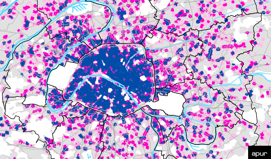
    European cities represent the landfall territory, the threshold to cross and a place to live in. They also represent a place to build a new idea of the city itself, and of the society that could be. In the framework of an epochal migration crisis, my research took on an ethical aspect within urban policies. Maps become, in this context, tools to try and describe European cities differently from how they have always been represented and conceived. A migratory phenomenon of unthinkable proportions until ten years ago found in Europe inhospitable land, unable not only to host the populations that press on its borders, but also to see their possible contribution in the wider horizon of ideation and planning. As such, maps represent a city knowledge device in terms of building of a new awareness of the city itself.

    A new project was conceived, “Migrants mapping Europe”, aimed at applying the method introduced in Milan to other Italian and European cities, starting with the exploration of Bologna and Rovereto. This is the second phase of research, aimed at incrementally building a European map of the present time that brings to surface the meaning and forms of the first landing and of the transitory living conditions in the territories of contemporaneity.


    4. What were your expectations at the beginning of your project? Have they changed whilst carrying out research? If so, how?

    At the beginning of the research project, I did not expect the reaction received from of almost all the participants who were asked to draw their cognitive maps. However, the initial disorientation, disbelief, incomprehension, and often the interviewee’s resistance to draw, progressively disappeared. It was replaced by the surprising acceptance of that improbable challenge, which induced 150 migrants to a creative observation of the city, fully participating in a project that had no purpose that was immediately evident.

    What I understood and changed whilst carrying out my research is the necessity to project the interviewee into the current experience within the landing city, without looking back towards their past experiences, but rather focussing on their immanent condition.

    When, at the beginning of the survey, some participants were asked to speak about their backgrounds, their migration journey, their past, before drawing the map, those migrants found it impossible to draw any map, at all. Looking at the city they currently live in was actually the only way for them to be able to draw. It has proved to be a determining factor for the actual creation of the maps, and it has further convinced me that it was much more critical to invite participants to think about their current living conditions, rather than asking them to look back to their personal history.


    5. How do you ensure inclusion and participation in your projects? And how do you create a safe space for individuals to share their connection to the city as well as their personal history?

    I try to speak about the kind of participation involved in this experiment, and about its significance from the newcomers’ point of view. Amidst widespread and growing efforts to conduct participatory research, this survey has a particular goal, that is to offer a possibility for migrants to appropriate the city by recognizing their relationship to the urban space. Through their drawings of the map, they develop their sense of belonging to the city. The representation of the urban landscape drawn by migrants who are trying to find their bearings in the city is an act of self-organization within the landscape. The action of imagining and drawing the urban geography corresponds to the act of mentally inhabiting the city and in this way taking possession and transforming it from a space of estrangement into a space which is more articulated and complex, where even a person who has recently arrived can conceptualize and live within it. This is the reason why it is important for migrants to look at the city and not to look back at their history. We can say that the exercise of mapping makes explicit the act of taking to oneself to a space which, no longer about an estranging experience, becomes a space open to unpredictable inhabiting conditions.

    There is an ethical reason for this kind of participatory process. It is the opportunity to listen to participants’ point of view with the intention of building a level of equality between the expert and the disorientated gaze: It is an attempt to overcome the prerogative of power over the other that has always divided those who belong—to a territory, to a right, to a system—from those who are excluded.


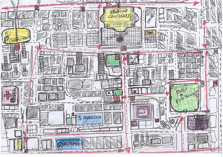
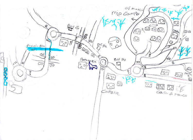
    6. Could you share three maps that convey a particularly strong visualisation of how people with migration backgrounds perceive cities of transit?

    I chose one map of Bologna, one of Rovereto and one of Milan, which are the first three Italian cities included into the project “Migrants mapping Europe”. These surveys are going to be published in the second edition of my book with the title “La città sradicata. L’idea di città attraverso lo sguardo e il segno dell’altro” [The Uprooted City] (2020, O barra O edizioni, Milano)

    http://journal.urbantranscripts.org/wp-content/uploads/2020/05/in_np_bologna_mahamadou_mali_750px.jpg http://journal.urbantranscripts.org/wp-content/uploads/2020/05/in_np_rovereto_masane_750px.jpg http://journal.urbantranscripts.org/wp-content/uploads/2020/05/in_np_milano_ako_togo_750px.jpg

    7. Your projects have investigated and voiced migrants’ perceptions of several cities, how were these settings similar and different from one another?

    In all the cities so far involved, the sample of interviewees included people from all over the world and who had not yet settled in the city. Thus, they had a mobile point of view, characterized mainly by instability.

    The instruments used for each interview were a sheet of A4 paper, pens, crayons and markers, which were left on the table available to the interviewees to choose the most appropriate graphical tools to draw their map. On the back of the map, newcomers were asked to write their name, age, country of origin, the location of their hometown, and duration of stay in that city.

    The interview also included information, if participants were willing to share, on the migratory path and the current working situation, to build a more complex picture of their condition. However, as I was saying earlier, the survey did not focus on the reasons for migration, nor the living conditions in the original country; the idea was to bring the newcomer directly to his current condition, to open up a reflection on the arrival city.

    The locations of interviews were different in the various cities, depending on the context in which the research originated. While in Milan they were chosen to reflect the heterogeneity of places where newcomers have their main activities, in the other Italian cities, interviews took place where the group of participants involved lived (Bologna) or where they attended school (Rovereto). In Paris, a group of people with migration backgrounds was interviewed at the École Normale Supérieure where they were attending an integration program with local associations.


    8. Who would you say is the target audience of your work and how has your work been received so far?

    At the beginning I thought I would address my work to urban planners. In fact, I used an interdisciplinary method to investigate the city, other disciplines were interested in opening up a dialogue with my research. Serveral discussions, in Italy and abroad, found food for thought and fertile ground for cross pollination in the areas of geography, anthropology, sociology, and the sciences of representation, in addition to the field of urban planning. The workshops I developed in the different cities are the results of these cross-pollinations . Recently, I took part in a seminar of postcolonial studies and it was on this occasion that I conducted the last workshop with migrants in Paris.


    9. What are going to be the next developments of your projects?

    The next developments of “The Uprooted City” are to map new cities, with the idea of changing the point of view on Europe as a whole. My hypothesis now is to propose an idea of Europe whose identity is not predefined. It is the possibility that its representation could be transformed by the observation of migrants, and it is the idea and the wish that Europe may be able to transform itself in relation to the foreigner who is coming. It is a hope that migrants could induce each city to represent itself with another map, in a framework oriented not to speak in the name of the other, but to allow the other to lead the narrative of the city.

    ▻http://journal.urbantranscripts.org/article/seeing-the-city-with-nausicaa-pezzoni-on-mapping-perceptio

    #urbanisme #villes #géographie_urbaine #visualisation #cartes_mentales #cartographie #migrations #instabilité #planification_urbaine #permanence #mobilité #expérience #représentations #Kevin_Lynch #Milan #cartographie_participative #appartenance #dessin #Bologna #Rovereto

    –-> la référence à l’afflux sans précédent de migrants en Europe et la « crise migratoire » semblent vraiment ne pas réussir à s’effacer, même pour les personnes avec les meilleures intentions du monde :

    In the framework of an epochal migration crisis, my research took on an ethical aspect within urban policies. Maps become, in this context, tools to try and describe European cities differently from how they have always been represented and conceived. A migratory phenomenon of unthinkable proportions until ten years ago found in Europe inhospitable land, unable not only to host the populations that press on its borders, but also to see their possible contribution in the wider horizon of ideation and planning.

    ping @reka

    CDB_77 @cdb_77
    • @fil
      Fil @fil 21/02/2021

      superbe !

      Fil @fil
    Écrire un commentaire
  • @reka
    Phil Reka docs & archives @reka CC BY-NC-SA 25/08/2020

    Décentraliser n’est pas démocratiser - regards.fr
    ▻http://www.regards.fr/politique/article/decentraliser-n-est-pas-democratiser

    http://www.regards.fr/IMG/png/btv1b53062034s_f1.png

    C’est un faux débat par excellence. La ville est devenue le territoire par excellence de l’organisation sociale, et la métropolisation est le pivot de son expansion. Dès lors, revient sur le devant de la scène ce sempiternel débat sur l’obsolescence de l’État national. Si l’État désigne la puissance publique, il ne relève pas d’un seul territoire. La commune ne fait pas moins partie de la sphère étatique que le département, la région, la nation ou les institutions continentales. La question traditionnelle est de savoir comment fonctionne le grand « tout » de l’État : de façon centralisée ou décentralisée. Dans les dernières décennies, la réponse s’est portée vers la seconde hypothèse, ce que l’on peut tenir pour un progrès.

    #décentralisation #urban_matter #planification_urbaine #ville

    Phil Reka docs & archives @reka CC BY-NC-SA
    • @marclaime
      Marc Laimé @marclaime 25/08/2020

      La « participation citoyenne » est le nouveau pont-aux-ânes du gauchisme culturel propre à la petite bourgeoisie intellectuelle qu’incarne parfaitement Regards entre autres. Ces incantations sans lendemain achoppent toujours sur la réalité des processus décisionnels qui associent les opérateurs privés dominants, l’Etat, le politique, et l’immense armée de réserve d’idiots utiles qui aident à faire fonctionner le tout. Essayez un peu de proposer des ruptures qui permettraient d’un finir avec l’opacité desdits processus décisionnels et vous verrez immédiatement se constituer une sainte alliance des « décideurs » bien décidés à interdire au commun des mortels de s’occuper de leurs affaires...

      Marc Laimé @marclaime
    • @cdb_77
      CDB_77 @cdb_77 25/08/2020

      #métropolisation #géographie_urbaine

      CDB_77 @cdb_77
    Écrire un commentaire
  • @hlc
    Articles repérés par Hervé Le Crosnier @hlc CC BY 23/08/2020

    When June Jordan and Buckminster Fuller Tried to Redesign Harlem | The New Yorker
    ▻https://www.newyorker.com/culture/culture-desk/when-june-jordan-and-buckminster-fuller-tried-to-redesign-harlem

    https://media.newyorker.com/photos/5f402bba9a557880d973bc49/16:9/w_1280,c_limit/Schwartz-SkyriseforHarlem.jpg

    The uprisings coincided with a turbulent period in Jordan’s life. A week after the riots, Jordan’s husband wrote to say that he wouldn’t be returning to their home; Jordan, increasingly destitute, sent her son to his grandparents. She wrote to Fuller, he responded almost immediately, and they spent several months drafting “Skyrise for Harlem,” a plan for a neighborhood where residents had long been subjected to constant policing, cramped quarters, and dilapidated schools. Their plan would transform Harlem without displacing any of its existing residents, who often became the collateral damage of “urban renewal” (or what Jordan and others called “Negro removal”). Urban renewal involves the designation of certain areas as “blight”—a term disproportionately applied to low-income Black and brown communities—in order to justify demolition of existing structures and authorize new building. The practice was exemplified by Robert Moses, whose now-infamous Cross Bronx Expressway, for example, relied on denying the rich cultural networks and microeconomies of East Tremont, which were then destroyed by the highway’s construction.

    In contrast with urban-renewal projects that devalued Black and brown populations, Fuller and Jordan’s design sought to transform the environment in service of Harlem’s residents. The plan was ambitious, but drastic measures were required. “Partial renovation is not enough,” Jordan wrote. “A half century of despair requires exorcism.” Columns installed in backyards would act as stilts so that construction of fifteen fireproof, conical towers could take place above existing buildings. These towers would contain new dwelling space—light-filled apartments of twelve-hundred square feet, each equipped with a balcony and parking spot—as well as studios, concert halls, theatres, athletic fields, and recreational space. Parking ramps and suspension bridges would cut through the towers, and green space and collective leisure areas would be expanded. After construction was completed, the residents who lived in the buildings below would simply move up to the improved units. After residents had settled into their new units, the old units would be “converted into communal, open space for recreation, parking and so forth.”

    Under her married name, Meyer, Jordan wrote about “Skyrise for Harlem” in the April, 1965, issue of Esquire. Jordan chaffed against Esquire’s stipulations. “The limitation of 2500 words seems to me arbitrary and acceptable only if it becomes possible to adequately condense to a poetry of form the verbal aspect of the piece,” she wrote to Fuller, emphasizing the project’s allegiance to radical imagination. In the article, Jordan omitted her own integral role in the project—perhaps to seize on the celebrity of her collaborator, who had appeared on the cover of Time the previous year. “Fuller’s design,” “Fuller’s circular decked towers,” “Fuller’s solution,” Jordan wrote. Still, their shared enthusiasm for the transformative potential of design comes through: “There is no evading architecture, no meaningful denial of our position. You can build to defend the endurance of man, to protect his existence, to illuminate it. But you cannot build for these purposes merely in spasmodic response to past and present crises, for then crisis, like the poor, will be with us always.”

    Jordan submitted the article under the headline “Skyrise for Harlem,” but the editors replaced it with one of their own, “Instant Slum Clearance,” which encapsulated precisely the dominant urban-planning idea that Jordan and Fuller’s design rejected: that Black residents were a form of contamination who had to be removed for a neighborhood to flourish. The subtitle—“R. Buckminster Fuller designs a total solution to an American dilemma: here, for instance, is how it would work in Harlem”—clinched the project’s attribution to Fuller and reversed Jordan’s guiding question, “What was I for?” It cast the plan from one motivated by the love of a particular place into one preoccupied with a generalized violence.

    The check from Esquire arrived on December 24, 1964. “I pleaded with the bank to cash the check, immediately,” Jordan recalled. Then she headed to the airport to pick up her son, who made it home just in time for Christmas.

    “Skyrise for Harlem” never made it off the page. Although Jordan insisted that the pair fully expected the plan to be carried out, its fate was hardly an anomaly for Fuller, whose spectacular ideas regularly outpaced his commitment to seeing them through. Unlike many of Fuller’s other brainstorms, however, engagements with “Skyrise” have been scattershot. A few sources have covered the project, without giving credit to Jordan. A 1965 article in the Southern Illinoisan, Fuller’s local newspaper, described the proposal, giving sole credit to Fuller. The Whitney’s exhibition “Buckminster Fuller: Starting with the Universe,” from 2008, included the blueprint by Fuller’s associate Shoji Sadao that appeared alongside the Esquire article, with no mention of Jordan. Jordan wrote about the project’s genesis and her frustration with Esquire’s editorial changes in “Civil Wars.”

    #Planification_urbaine #Harlem #1964

    Articles repérés par Hervé Le Crosnier @hlc CC BY
    Écrire un commentaire
  • @reka
    Phil Reka docs & archives @reka CC BY-NC-SA 19/07/2020

    Juba, Sudan – Southern Sudan seeks to build a giant rhinoceros-shaped city | Essay | Architectural Review
    ▻https://www.architectural-review.com/essays/juba-sudan-southern-sudan-seeks-to-build-a-giant-rhinoceros-shaped-city/8606046.article

    https://www.architectural-review.com/pictures/2000x2000fit/5/1/4/1237514_AR10_VIEW_HIGH_RES_RHINO.jpg

    #architecture #planification_urbaine #rhino #juba #soudan

    Phil Reka docs & archives @reka CC BY-NC-SA
    Écrire un commentaire
  • @cdb_77
    CDB_77 @cdb_77 19/03/2020
    11
    @reka
    @antonin1
    @arno
    @gastlag
    @fbahoken
    @_kg_
    @josephine2
    @rumor
    @fredlm
    @suske
    @nicolas6
    11

    En ces temps où on nous demande de faire de la #continuité_pédagogique (►https://seenthis.net/messages/831759), des collègues partagent des idées de #films à suggérer aux étudiant·es confiné·es chez elleux...

    #ressources_pédagogiques #géographie #films_documentaires

    CDB_77 @cdb_77
    • @cdb_77
      CDB_77 @cdb_77 19/03/2020

      Film geographies :
      ►https://www.filmgeographies.com

      CDB_77 @cdb_77
    • @cdb_77
      CDB_77 @cdb_77 19/03/2020

      L’IRD Audiovisuel met à disposition une grande base de films de géographes (et d’autres disciplines) dont certains peuvent être vus en ligne notamment les films d’étudiants réalisés dans le master PED Paris 1 et Paris 7 sous la co-direction de Bernard Surugue.

      ▻https://audiovisuel.ird.fr/index.php

      CDB_77 @cdb_77
    • @cdb_77
      CDB_77 @cdb_77 19/03/2020

      Voici quelques ressources non exhaustives :

      – le site Doc2Geo, créé il y a plusieurs années par X. Browaeys : ►https://sites.google.com/site/doc2geo/visionner
      Il n’est plus vraiment à jour, mais possède un grand nombre de films très intéressants par des géographes.

      – le site d’hypothèse rassemble de nombreux films de recherche en sciences sociales qui sont associés à des textes de présentation (►https://sms.hypotheses.org)

      – le dernier numéro de la RFMV (Revue Française des Méthodes Visuelles) est consacré aux géographies audiovisuelles (►https://rfmv.fr/numeros/3). Vous y trouverez de nombreux liens vers des films à la lecture des articles.
      Notamment :
      – un film d’O. Bories sur l’#urbanisation des #terres_agricoles (►https://sms.hypotheses.org/19065)
      – un film de Marie Chenet sur la question du #loup en #France (►https://vimeo.com/212742493

      )
      –un autre sur l’apprentissage de la #géomorphologie par le terrain (►https://medihal.archives-ouvertes.fr/medihal-01178310)
      – un film de Benoit Raoulx sur des ramasseurs de #déchets à #Vancouver (►https://www.canal-u.tv/video/cerimes/traplines_in_vancouver.9476)
      – un autre sur la vie d’un #marché au #Venezuela (►https://www.canal-u.tv/video/cerimes/las_playitas.13575)
      – un film de Floriane Chouraqui sur le #risque_volcanique au #Cap-Vert (►https://sms.hypotheses.org/10522).

      Citons aussi le travail de Laura Corsi qui a réalisé des magazines télévisuels sur l’#entreprenariat dans les #îles_du_Ponant (►https://www.id-iles.fr).

      CDB_77 @cdb_77
    • @cdb_77
      CDB_77 @cdb_77 19/03/2020

      5 vidéos courtes sur des scénarios de #transition_énergétique en ville.
      Centré sur un des acteurs-pivots de l’#énergie et de l’#urbanisme (Collectivités locales, Etat, entreprises gestionnaires de l’énergie, coopératives d’habitants), chaque scénario présente les implications à trois niveaux : bâtiment, ville et Pays.

      ►https://www.youtube.com/playlist?list=PLIXAicJJXv1Cq1GymN_D6w03xS2k4q_Rc

      CDB_77 @cdb_77
    • @cdb_77
      CDB_77 @cdb_77 19/03/2020

      Dans le cadre d’un projet de recherche sur la place des #patrimoines dans la #planification_urbaine, nous avons mis en ligne un certain nombre de ressources vidéos, dont un documentaire d’une trentaine de minutes intitulé « A la recherche du #PLU patrimonial » (▻https://www.canal-u.tv/video/plu_patrimonial/a_la_recherche_du_plu_patrimonial.50841).

      Toutes les vidéos sont en accès libre et gratuit sur une chaîne Canal-U dédiée : ▻https://www.canal-u.tv/producteurs/plu_patrimonial
      #patrimoine

      CDB_77 @cdb_77
    • @cdb_77
      CDB_77 @cdb_77 19/03/2020

      CBC a fait cet inventaire de films autochtones en ligne : ►https://www.cbc.ca/arts/there-s-a-massive-free-catalogue-of-indigenous-films-online-and-we-have-6-picks-

      Et deux podcasts, que vous connaissez peut-être déjà :

      – Kiffe ta race, sur les rapports sociaux de race : ▻https://www.binge.audio/category/kiffetarace

      – et les couilles sur la table, sur les masculinités : ▻https://www.binge.audio/category/les-couilles-sur-la-table

      CDB_77 @cdb_77
    • @cdb_77
      CDB_77 @cdb_77 19/03/2020

      Ce n’est pas un film de géographe mais c’est un très beau film documentaire géographique :
      « Les femmes aussi... » série en 4 tableaux dont un sur les « travailleuses de la nuit à Paris » qui porte sur ces femmes de ménage qui se lèvent à 4h du matin ou encore plus tôt pour nettoyer les bureaux, les gares, etc.
      1967. En noir et blanc. Archive INA, mise sur youtube :
      ▻https://www.youtube.com/watch?v=611FiGKm-jE

      De la belle géographie sociale, et une façon de filmer fort intéressante aussi.

      et depuis ce film là on peut enchainer sur d’autres films de l’époque tout aussi bien (je suis en train de surfer sur un film sur la mémoire de Belleville).

      Et je vous recommanderais bien Ils ont filmé les grands ensembles, travail de recueil puis de montage de films-amateur tournés par les 1ers habitants des grands ensembles de la banlieue parisienne. Très utile pour faire vraiment saisir à nos étudiants que ces quartiers n’ont pas toujours été, et ne sont toujours pas pour bcp d’entre eux, des repoussoirs et zones franches où règne la violence.
      Mais il n’est pas disponible en ligne. Bcp de BU ont le DVD, mais elles sont fermées pour l’instant. Mais à garder ds votre filmo pour des jours meilleurs.

      CDB_77 @cdb_77
    • @cdb_77
      CDB_77 @cdb_77 19/03/2020

      Le première choque qui devrait interpeller le géographe est l’étymologie du mot « confinement », le « confin » désignant à peu près le contraire de la situation qui nous est imposée.

      En Russie, une série assez populaire sur la 1ère chaîne, На краю ("sur le confin") met en scène des péripéties en dehors du pays, vers le proche-Orient... où ils se retrouvent en captivité : voir sur Яндекс : ▻https://yandex.ru/search/?text=%D0%BD%D0%B0%20%D0%BA%D1%80%D0%B0%D1%8E&clid=1985050-165&win=220&lr=112

      Sur le confin, c’est aussi une chanson d’Emin, un chanteur russo-azéri.
      Emin - На краю
      ▻https://www.youtube.com/watch?v=L1tCH66ZX44

      « Sur le confin - deux coeurs Solitaires, deux mélodies.
      Sur le confin de l’amour, la route n’est pas terminée.
      Nous y sommes comme en apesanteur. »

      CDB_77 @cdb_77
    • @cdb_77
      CDB_77 @cdb_77 19/03/2020

      Filmer les grands ensembles 2016
      ▻https://www.youtube.com/watch?v=VDUBwVPNh0s

      J’utilise aussi (très court et néanmoins intéressant) :

      ▻https://www.ina.fr/video/CAF89027084
      11 avril 1964, émission Journal de Paris à l’Télévision française

      ▻https://www.ina.fr/video/AFE85009790/ces-miserables-cites-qu-on-nomme-bidonvilles-video.html
      9 janvier 1963, le journal « les actualités françaises »

      CDB_77 @cdb_77
    • @cdb_77
      CDB_77 @cdb_77 20/03/2020

      La conférence de J-B FRESSOZ (historien des sciences) est très utile à tout géographe qui veut comprendre les liens entre énergie - automobile - maison individuelle - lobbys et plus globalement l’étalement urbain et la transition énergétique et écologique.

      ►https://www.youtube.com/watch?v=lO0r5O4-2wU

      CDB_77 @cdb_77
    • @cdb_77
      CDB_77 @cdb_77 20/03/2020

      Deux excellents reportages réalisés par le géographe Olivier Archambeau et des étudiant.e.s du Pôle image du département de géographie de l’Université Paris 8 sur la route 66 et les Great Northern et Stuart Higways (Australie), et que vous pourrez trouver sur Viméo en consultant les liens suivants : ▻https://vimeo.com/35060677

      (route 66) et ▻https://vimeo.com/35057618
      ( Great Northern et Stuart Higways).

      CDB_77 @cdb_77
    • @cdb_77
      CDB_77 @cdb_77 20/03/2020

      N’oublions pas le site MédiHAL (▻https://medihal.archives-ouvertes.fr) petit frère de HAL et inventé par des géographes et des archéologues il y a quelques années à Bordeaux et à Paris, dans le cadre du TGE Adonis devenu Huma-Num (bien connu pour son outil de recherche Isidore) : il y a des vidéo(s) de géographes (trop peu) à visionner et on peut surtout y déposer des photos mais aussi des vidéo(s).

      CDB_77 @cdb_77
    • @rumor
      Rumor @rumor CC BY-NC-SA 20/03/2020
      @cdb_77 @seenthis

      merci @CDB_77 pour la double initiative de populariser @seenthis et pour avoir regroupé toutes ces formidables ressources. Ne reste plus que d’arriver à trouver un créneau préservé du flux pour les regarder...

      Rumor @rumor CC BY-NC-SA
    • @antonin1
      Antonin @antonin1 CC BY-NC-SA 20/03/2020

      Merci ! J’adore « KIffe ta race » et « Les couilles sur la table ».

      Antonin @antonin1 CC BY-NC-SA
    • @rumor
      Rumor @rumor CC BY-NC-SA 20/03/2020

      à signaler aussi :
      Barons sans descendance, « Martine Aubry, la dame de Lille », « Gaudin, l’heure de l’inventaire », « De Gérard à Monsieur Collomb », « Juppé, un roman bordelais », films documentaires, 13 Productions, 2019. URL : ▻https://www.13productions.fr/barons-sans-descendance
      avec une recension de Nicolas Maïsetti sur Métropolitiques : ▻https://www.metropolitiques.eu/Barons-sans-descendance-portraits-de-maires-de-grandes-villes.html

      Rumor @rumor CC BY-NC-SA
    • @cdb_77
      CDB_77 @cdb_77 20/03/2020

      Dans la continuité du message sur les films réalisés par Olivier Archambeau, je vous signale son dernier film sur Port-au-Prince dans le cadre du programme de recherche PRCU. ▻https://vimeo.com/224445414

      Lavil andeyo (La ville en dehors)

      CDB_77 @cdb_77
    • @cdb_77
      CDB_77 @cdb_77 20/03/2020

      Dessin animé de la conférence de #David_Harvey sur la #crise_financière :

      ▻https://www.thersa.org/discover/videos/rsa-animate/2010/06/rsa-animate---crisis-of-capitalism
      ▻https://www.youtube.com/watch?v=qOP2V_np2c0&feature=emb_logo

      CDB_77 @cdb_77
    • @cdb_77
      CDB_77 @cdb_77 20/03/2020

      films de géographes que j’ai appréciés :
      – le film de Jacques Lévy Urbanité/s (1h17) ►https://vimeo.com/84457863

      disponible aussi en anglais
      Le film explore le concept d’urbanité à travers l’observation des villes du Monde, tout particulièrement en Chine. Ce projet théorique ambitieux propose aussi un intense dialogue avec les « villes invisibles » d’Italo Calvino. Il s’agit enfin d’un film-manifeste, une contribution à l’invention d’un langage cinématographique contemporain pertinent pour le travail scientifique.

      – la série Thinking places, là encore avec sous-titres possibles, pilotée par le même Jacques Lévy

      Thinking Places est une série de neuf films scientifiques dont le principe est d’associer, par le langage du cinéma, le discours d’un chercheur travaillant sur l’espace à un lieu que ce chercheur a lui-même choisi parce ce lieu l’a changé. Il s’agit donc d’un dialogue entre deux personnages de cinéma, un penseur-acteur et un lieu.

      Chaque film est fondé sur quatre règles :
      – La personne et le lieu doivent être filmés simultanément.
      – Le film comprend un seul plan-séquence
      – Le tournage est limité à une seule prise.
      – Le lieu filmé est ce dont parle la personne filmée.
      La durée est fixée librement par le chercheur lui-même (de moins d’une demi-heure à plus d’une heure).

      Jacques m’a confirmé que la formule appelle à être dupliquée par toute personne géographe intéressée. Si certains ou certaines ont été changées par leur appartement ou leur maison de confinement, à votre caméra !

      Béatrice Collignon/Ottawa, 32 min, français ▻https://vimeo.com/album/3575603/video/139349603
      Jean-François Staszak/Boston, 29 min, français ▻https://vimeo.com/album/3575603/video/140032297
      John Agnew/Belfast, 24 min, anglais, sous-titres français ▻https://vimeo.com/album/3575603/video/140032827
      Franco Farinelli/Florence, 37 min, italien, sous-titres français ▻https://vimeo.com/album/3575603/video/139431686
      Paola Viganò/Courtrai + Anvers, 47 min, anglais, sous-titres français ▻https://vimeo.com/album/3575603/video/140033453
      Michel Lussault/Lyon, 57 min, français ▻https://vimeo.com/album/3575603/video/139361302
      Augustin Berque/Imintanoute (Maroc), 66 min, français ▻https://vimeo.com/album/3575603/video/139361284
      Susanne Rau/Grande Canarie, 37 min, allemand, sous-titres français ▻https://vimeo.com/album/3575603/video/140035483
      Jacques Lévy/Séoul, 34 min, français ▻https://vimeo.com/album/3575603/video/139346092

      CDB_77 @cdb_77
    • @_kg_
      -KG- @_kg_ 20/03/2020
      @cdb_77

      MERCI @cdb_77, j’en ai pensé aussi, de regrouper ici, mais t’as été plus vite, trop bien ! :)

      -KG- @_kg_
    • @bm27
      bm27 @bm27 20/03/2020

      bonjour,
      je me permets de rajouter le film qu’on a réalisé pour la Région Grand Est à l’occasion de la commémoration des inondations de décembre 1919. ▻https://www.youtube.com/watch?v=tHPEOLlkxMg

      bm27 @bm27
    • @alexiab
      alexiab @alexiab 20/03/2020

      6 minutes pour parler de genre & mobilités : ►https://vimeo.com/151365379

      alexiab @alexiab
    • @cdb_77
      CDB_77 @cdb_77 21/03/2020

      Vidéos réalisées dans le cadre du projet de recherche-action « Map & Jerry » que nous avons mené avec Martin Lozivit et l’IRD au #Bénin.
      Il s’agit d’un projet d’#innovation_numérique et de #cartographie_participative conduit avec des jeunes d’un quartier précaire, un #fablab local et la communauté Open StreetMap.

      – Vidéo bilan du projet : ▻https://youtu.be/8f6sknx7sTQ


      – Vidéo de la fabrication des Jerry (phase 1) : x6w21ir.m3u8

      Deux articles permettent de compléter ces vidéos :

      Armelle Choplin et Martin Lozivit, « Mettre un quartier sur la carte : Cartographie participative et innovation numérique à Cotonou (Bénin) », Cybergeo : European Journal of Geography [En ligne], Espace, Société, Territoire, document 894, mis en ligne le 02 mai 2019, consulté le 20 mars 2020. URL : ▻http://journals.openedition.org/cybergeo/32152 ; DOI : ▻https://doi.org/10.4000/cybergeo.32152

      Armelle Choplin & Martin Lozivit, « Les fablabs en Afrique : l’innovation numérique au service d’une ville durable ? », Métropolitiques, 20 janvier 2020. URL : ▻https://www.metropolitiques.eu/Les-fablabs-en-Afrique-l-innovation-numerique-au-service-d-une-ville

      CDB_77 @cdb_77
    • @cdb_77
      CDB_77 @cdb_77 22/03/2020

      Anarchist Film Archive

      ►https://christiebooks.co.uk/anarchist-film-archive
      #anarchisme

      CDB_77 @cdb_77
    • @cdb_77
      CDB_77 @cdb_77 22/03/2020

      Nomad Maps, une #itinérance_cartographique andine à #vélo
      ▻https://peertube.openstreetmap.fr/videos/watch/384d14d7-9d19-4d15-a958-74aae719b48f
      –-> film documentaire de 28 min, voici le synopsis :

      #Alban_Vivert, géographe et cartographe, de formation -
      et surtout de passion -, a pédalé pendant 6 mois à
      travers les Andes colombiennes, équatoriennes et
      péruviennes, à la rencontre des membres locaux de la
      communauté cartographique libre #OpenStreetMap.
      Durant ce périple en totale autonomie entre lui à sa
      bicyclette, il a tendu le micro aux acteurs et
      contributeurs de cette carte collaborative du monde afin
      de connaître leur implication et la motivation qui les
      animent dans ce vaste projet mondial collaboratif qui
      entend donner le pouvoir des cartes aux citoyens.
      Ce road movie est une invitation au spectateur à se
      questionner sur l’usage et l’utilité des cartes dans nos
      sociétés contemporaines où celles-ci occupent un
      espace croissant dans nos quotidiens que peu
      soupçonnent.

      #cartographie_participative #cartes

      CDB_77 @cdb_77
    • @cdb_77
      CDB_77 @cdb_77 22/03/2020

      Les films de #Tarkovsky sont désormais en ligne

      Andreï Tarkovsky (1932-1986) est reconnu comme le meilleur réalisateur soviétique de la période d’après guerre. Et son influence s’est étendue bien au delà de l’Union Soviétique.

      ►https://russie.fr/films-tarkovsky-en-ligne

      CDB_77 @cdb_77
    • @cdb_77
      CDB_77 @cdb_77 23/03/2020

      LISTE DE RESSOURCES DE GEOGRAPHIE POUR LE SUPERIEUR
      VIDEO / AUDIO / COURS EN LIGNE : RESSOURCES GRATUITES ET SANS ABONNEMENT EXCLUSIVEMENT

      ▻https://pads.aliens-lyon.fr/p/9foe-geoconfines?lang=fr

      CDB_77 @cdb_77
    • @cdb_77
      CDB_77 @cdb_77 23/03/2020

      La géographie, c’est vraiment utile ?
      Pitch chaîne Boussole, vidéo YouTube de vulgarisation, 4’30, niveau débutant : ▻https://www.youtube.com/watch?v=RASyN8gAKKo

      CDB_77 @cdb_77
    • @cdb_77
      CDB_77 @cdb_77 23/03/2020

      La Crise de l’#Euro.
      Une suite de vidéo [20 minutes chacune] sur la crise de l’Euro, incluant ses aspects géographiques, par la chaîne de vulgarisation économique Heu ?Rêka.
      ▻https://www.youtube.com/watch?v=5uBXviM1PcQ&list=PLbHgDl1izvblo60rgF3r-gmq5ttWq6CCt


      #monnaie

      CDB_77 @cdb_77
    • @cdb_77
      CDB_77 @cdb_77 27/03/2020

      Pour la Nuit de la Géo spécial confinement, la Géothèque vous propose de découvrir le 3 avril le documentaire « #L'image_qu'on_s'en_fait », dont la projection était prévue initialement comme un temps fort de la Nuit de la Géographie de Lyon annulée comme beaucoup d’autres événements pour cause de crise sanitaire.

      Nous vous proposons donc de plonger dans ce film autour des « #panneaux_marrons » jalonnant les #autoroutes de France, pour réfléchir à leur sens et aux représentations des territoires qu’ils construisent et reflètent...

      Soyez nombreux.ses au rendez-vous en ligne le 3 avril, pour voir le film entre 10h et 21h et rencontrer le réalisateur sur Facebooklive à partir de 21h ! Gratuit, sur inscription à geotheque@gmail.com (un lien et code d’accès vous seront alors communiqués).

      ▻https://www.franceinter.fr/emissions/capture-d-ecrans/capture-d-ecrans-05-mars-2020?xtmc=_coupy_&xtnp=1&xtcr=5

      ▻https://www.facebook.com/events/503002057084487

      CDB_77 @cdb_77
    • @rumor
      Rumor @rumor CC BY-NC-SA 27/03/2020

      HENRI LEFEBVRE – LE DROIT À LA VILLE. UN FILM DE JEAN LOUIS BERTUCCELLI, 1974

      Henri Lefebvre (1901-1991), est un marxiste « indépendant », en cela il se présente comme « marxien », même si à plusieurs reprises il chemine avec le Parti communiste français (PCF). Il se dit également « utopien » et un temps « situationniste ». Incroyablement inventif et intuitif, il perçoit l’importance de la vie quotidienne et y consacre trois ouvrages majeurs (Critique de la vie quotidienne, 1947, 1962 et 1981), de l’urbanisation et de la ville qu’il analyse dans six ouvrages (Le droit à la ville, 1968 ; Du rural à l’urbain, 1970 ; La révolution urbaine, 1970 ; La pensée marxiste et la ville, 1972 ; Espace et politique, 1973 et La production de l’espace, 1974), de l’informatique (Vers le cybernanthrope, contre les technocrates, 1973), de l’altérité (Manifeste différentialiste, 1971), sans compter ses

      réflexions sur l’État, la dialectique, le marxisme…

      www.eterotopiafrance.com/catalogue/elements-de-rythmanalyse-et-autres-essais-sur-les-temporalites/

      Rumor @rumor CC BY-NC-SA
    • @cdb_77
      CDB_77 @cdb_77 1/04/2020

      Conseils généraux de sites mentionnés par les un.e.s et les autres

      Canal U, du collège de France, de FUN Mooc , plateforme TENK, ▻https://imagesdelaculture.cnc.fr/web/guest/catalogue-general
      Le site archive.org mentionné par l’EHESS propose une banque de donnée en libre accès impressionnante : ici le lien vers leur catégorie « films académiques et culturels » : ▻https://archive.org/details/culturalandacademicfilms

      L’université de Genève met en libre accès des films d’étudiants de leur atelier (thèmes : frontières, villes, utopies etc).
      ▻https://www.unige.ch/sciences-societe/geo/etudes/master-1/atelierfilms

      Le volet « films » du site « Mondes Sociaux », un magazine interdisciplinaire en ligne du Labex SMS dont l’objectif principal est de valoriser des recherches autour des notions suivantes : réseaux, régulations, dispositifs et territoires. Donc pas mal de trucs en lien avec la géo ! ▻https://sms.hypotheses.org/category/film-recherche

      La vidéothèque du CNRS

      Le site Doc2Geo, créé il y a plusieurs années par X. Browaeys ►https://sites.google.com/site/doc2geo/visionner

      CBC a fait cet inventaire de films autochtones en ligne : ►https://www.cbc.ca/arts/there-s-a-massive-free-catalogue-of-indigenous-films-online-and-we-have-6-picks-

      CDB_77 @cdb_77
    • @cdb_77
      CDB_77 @cdb_77 1/04/2020

      La première loi de la géographie ; Des villes en systèmes dans le monde ; Réseaux et graphes en sciences sociales : accessibles via FUN MOOC

      CDB_77 @cdb_77
    • @cdb_77
      CDB_77 @cdb_77 1/04/2020

      « voici trois courts métrages de 8’ sur certaines activités de recherches de l’IFP (écologie, manuscrits, photos) :
      ▻https://www.ifpindia.org/content/cnrs-images-m%C3%A9dia-3-courts-m%C3%A9trages-sur-les-activit%C3%A9s-de-re

      Ils sont disponibles aussi sur ▻https://videotheque.cnrs.fr, qui est surement une mine ».

      « Un film (vieux mais encore largement d’actualité), sur les évolutions de l’irrigation en Inde… ». Écrit et réalisé par Nathanaël Coste et Nicolas Ploumpidis. Ce documentaire aborde la question de la gestion de l’eau en Inde du Sud, sujet d’inquiétude sous-jacent en ville comme à la campagne. Laissant la parole aux acteurs locaux, il montre comment la gestion de l’eau a évolué au cours des dernières décennies et comment cette ressource tant convoitée peut être source de prospérité mais aussi d’expériences amères. L’eau apparaît ici clairement comme un révélateur des enjeux auxquels se trouve confrontée une société en plein bouleversement.

      Bittersweet Waters / Eaux douces, Eaux amères
      Written and Directed : Nathanael Coste & Nicolas Ploumpidis
      Co authors : Olivia Aubriot / Yanni Gunnell / Anupama Krishnamurthy
      Co production : IFP

      ▻https://bittersweetwaters.wordpress.com

      Bittersweet Waters (Eng)
      ▻https://vimeo.com/223454473

      Eaux douces, Eaux amères (Fr)
      ▻https://vimeo.com/223447091

      CDB_77 @cdb_77
    • @cdb_77
      CDB_77 @cdb_77 1/04/2020

      ▻https://parisdugenre.fr qui fait suite à un programme de recherche avec pleins de chercheuses en géographie, urbanisme, démographie, architecture... sur lequel on trouve deux films d’Anne Jarrigeon sur la mobilité des femmes et la libraire Violette and co. il y a aussi des films de Mina Saidi-Sharouz et Anne Jarrigeon sur les politiques publiques de genre de Barcelone et Berlin.

      ▻https://parisdugenre.fr/les-thematiques/mobilite/#toute-chose-egale-par-ailleurs-film

      ▻https://parisdugenre.fr/les-thematiques/politiques-publiques/#politique-degalite-a-berlin-justice-de-genre-a-barcelone-films

      CDB_77 @cdb_77
    • @cdb_77
      CDB_77 @cdb_77 1/04/2020

      Marie Chenêt - Entre chiens et loups : ►https://vimeo.com/212742493


      Béatrice Collignon - Des noms de lieux à la cartes en pays inuit : je n’ai pas retrouvé le lien, ▻https://halshs.archives-ouvertes.fr/halshs-00259422
      Benoît Raoulx - Traplines in Vancouver : idem
      Collectif Orangotango (de Berlin) - This is not an Atlas (documentaire sur les contre-cartographies) : ▻https://www.youtube.com/watch?v=T8-GKyy3j6I&t=1s

      Laura Corsi fait sa thèse en recherche-création sur les îles bretonnes, elle a produit pas mal de vidéos en ligne, tout est sur sa chaîne en ligne : ▻https://www.youtube.com/channel/UCUbP8k3Sy-pMrHQaEbfFS5g/videos
      Et quelques très bons films/série faits par des non-géographes :

      Invisibles. Les travailleurs du clic - 4 épisodes diffusés récemment (pas conçu par des géographes, plutôt sciences sociales, mais plein de trucs à en tirer d’un point de vue géographique). Série conçue avec la participation d’Antonio Casilli (approches critiques du numérique)
      ▻https://www.youtube.com/watch?v=ST_KVB6bEdw&list=PLUDzuI7to_hD6PswmzU0r9oSq048EDoY8


      Jeff Daniel Silva - Là où la terre : super film sur le quartier du Merlan dans les quartiers nord de Marseille d’un artiste chercheur en sciences sociales que j’aime beaucoup. Il y a un extrait ici, si ça t’intéresse je peux lui demander s’il serait d’accord pour donner le code d’accès : ▻https://lafabriquedesecritures.fr/catalogue/laoulaterre
      Philippe Cartelli et Mariangela Cicarello - Lampedusa : idem film d’artiste/chercheur en sciences sociale. Film très étrange et vraiment chouette sur la naissance d’une île en 1831 au large de la Sicile et ses conséquences géopolitiques.
      Helène Baillot et Raphael Botiveau - bientôt diffusé : (sur le passage de la frontière de la frontière franco-italienne dans les hautes alpes par les migrant-e-s) : ▻https://lafabriquedesecritures.fr/catalogue/premier-prix-technique
      Et bien entendu le programme du colloque de Bordeaux

      ▻https://colloquefilmgeo.wordpress.com/programme-geocinema

      CDB_77 @cdb_77
    • @cdb_77
      CDB_77 @cdb_77 1/04/2020

      Urbanités de Jacques Lévy : ►https://vimeo.com/84457863

      mais tu as dû le trouver
      Une conférence d’Augustin Berque : ▻https://www.youtube.com/watch?v=jqQ90ATU5ZI
      mais c’est pas un film et une autre de Berque : ▻https://www.youtube.com/watch?v=8XJYhtFAXOg
      sur l’esprit des lieux
      un vieux film de Jean Rouch qu’était pas géographe :
      ▻https://www.youtube.com/watch?v=JT5r5c8PYWA

      CDB_77 @cdb_77
    • @cdb_77
      CDB_77 @cdb_77 1/04/2020

      Sur canal u vous trouverez en accès libre un film sur la cafeiculture au Kilimandjaro que j’ai réalisé avec F. Devenne et S.Bouharaoura. il date de 2000 mais peut servir pour l’analyse des filières agricoles côté producteurs.

      ▻https://www.canal-u.tv/video/universite_toulouse_ii_le_mirail/cafeicultures_kilimanjaro_le_cafe_au_bois_dormant_bernard_charlery_de_la_mas

      CDB_77 @cdb_77
    • @cdb_77
      CDB_77 @cdb_77 1/04/2020

      « Ultima Patagonia rassemble de nombreux scientifiques dont un géographe de notre laboratoire, Richard Maire. Une version pirate est disponible sur YouTube :
      ▻https://www.youtube.com/watch?v=u5oFiCQ6Kbc

      Il y a tout un volet géomorphologie passionnant et riche avec des explications limpides et des images de structures uniques au monde, enrichi par un rythme façon aventure très agréable à voir. On en ressort l’esprit aéré, un peu humide, mais avec de magnifiques images dont une adorable petite chouette qui arrache des "ooooh" même aux plus insensibles. Très dépaysant pour les étudiants et étudiantes en mal de grands espaces ».

      CDB_77 @cdb_77
    • @cdb_77
      CDB_77 @cdb_77 1/04/2020

      Un film documentaire réalisé dans le cadre de son mémoire de master 2 à Bordeaux par une de mes étudiante de géographie Suzanne Le Maréchal Il s’intitule : Viaje’Arte l’art de voyager
      On le trouve sur youtube :
      ▻https://www.youtube.com/watch?v=9Uj_ZCZ6_Vs

      CDB_77 @cdb_77
    • @cdb_77
      CDB_77 @cdb_77 1/04/2020

      « Je peux vous suggérer ce film, que j’avais regardé en tant qu’étudiante dans un cours sur les pays en développement, il commence à dater mais il est bien conçu. Pour info, ce n’est pas diffusé via une plate forme légale » : ▻https://spoonconcept.com/main-basse-sur-le-riz

      CDB_77 @cdb_77
    • @cdb_77
      CDB_77 @cdb_77 1/04/2020

      « J’ai beaucoup aimé le film de la géographe Marie Chenet "Entre chiens et loups" qui propose une immersion dans le quotidien de Thierry Giordan, éleveur-berger des Alpes-Maritimes (►https://sms.hypotheses.org/9352), mais il y en a bien d’autres ...

      L’un de mes films est présent sur ce site, Fogo na Boca, sur la gestion de crise pendant l’éruption du volcan de Fogo (Cap-Vert) en 2014-2015 : ►https://sms.hypotheses.org/10522.

      Je serais très heureuse de partager ce film avec la communauté géographique, chercheurs et élèves, d’autant plus qu’il peut, à mon sens, servir pour faire un parallèle avec la gestion de crise actuelle.
      Si ça vous intéresse, mes autres films sont en libre accès sur Youtube, sur ma chaîne vidéo : ▻https://www.youtube.com/channel/UCVBSEBT9Zit1I-k1IJq_2WQ

      Si vous utilisez l’un de mes films pour vos cours et que vos étudiants font de l’analyse de contenu des discours (ou autre type d’analyse), j’aimerais beaucoup pouvoir savoir comment vous vous y prenez et éventuellement accéder à certains devoirs. C’est en effet passionnant de comparer les interprétations et réceptions des films en fonction des situations, publics, voire de l’actualité ».

      CDB_77 @cdb_77
    • @cdb_77
      CDB_77 @cdb_77 1/04/2020

      Il y a deux ans s’est déroulé à Bordeaux le colloque "Le film dans la pratique de la géographie".
      ►https://colloquefilmgeo.wordpress.com
      Un compte-rendu sous forme de fil Twitter est disponible, accessible à tous et toutes »
      ▻https://twitter.com/i/events/979650295864152065

      CDB_77 @cdb_77
    • @cdb_77
      CDB_77 @cdb_77 1/04/2020

      « Ce qui fait terrain. Fragments de recherche » ▻https://vimeo.com/40585715

      « Fabrique de l’océan Indien » ▻https://videotheque.cnrs.fr/index.php?urlaction=doc&id_doc=6630&rang=3

      CDB_77 @cdb_77
    • @cdb_77
      CDB_77 @cdb_77 1/04/2020

      « Quelques films-recherche de géographes ruralistes de l’équipe Dynamiques Rurales du laboratoire LISST (Laboratoire interdisciplinaire Solidarités, Sociétés, Territoires) à l’Université Toulouse 2 Jean Jaurès sont disponibles à cette adresse » : ▻https://www.dailymotion.com/Dynamiques-Rurales/videos?sort=visited

      CDB_77 @cdb_77
    • @cdb_77
      CDB_77 @cdb_77 1/04/2020

      « Nous avons réalisé des films sur le Brésil à Rennes 2 sous la direction de Robert Bariou, collègue hélas décédé récemment. Tu trouveras les liens sur ma page perso, rubrique "activités d’enseignement" et "Participation à la réalisation de documentaires" :
      ▻https://perso.univ-rennes2.fr/vincent.dubreuil#ancre_enseignement
      On peut les visualiser en ligne sans contrainte ».

      CDB_77 @cdb_77
    • @cdb_77
      CDB_77 @cdb_77 1/04/2020

      « Je n’ai pas de films de géographes sous la main, mais deux films qui peuvent être support d’analyse géographique.

      D’une part, Greepeace met à disposition gratuite le film qui a gagné le festival qu’ils organisent annuellement. Je n’ai pas vu celui-ci en particulier mais la sélection est toujours de qualité. Il croise crise écologique, trajectoires sociales et Monts du Lyonnais. Il est ici : ▻https://greenpeacefilmfestival.org/film/chemins-de-travers
      D’autre part, et là le décalage est plus grand, mais pour un cours sur la montagne ça peut intéresser : voici trois films gratuits d’un trailer de haute montagne (à défaut d’une vertu pédagogique le décentrement peut faire du bien) ▻https://www.theriderpost.com/disciplines/dirt/autres-dirt/trail/kilian-jornet-met-trois-de-ses-films-en-acces-libre

      CDB_77 @cdb_77
    • @cdb_77
      CDB_77 @cdb_77 1/04/2020

      « Le dernier numéro de la RFMV (Revue Française des Méthodes Visuelles) est consacré aux géographies audiovisuelles (►https://rfmv.fr/numeros/3). Vous y trouverez de nombreux liens vers des films à la lecture des articles. Notamment : un film d’O. Bories sur l’urbanisation des terres agricoles (►https://sms.hypotheses.org/19065), un film de Marie Chenet sur la question du loup en France (►https://vimeo.com/212742493

      ) et un autre sur l’apprentissage de la géomorphologie par le terrain (►https://medihal.archives-ouvertes.fr/medihal-01178310), un film de Benoit Raoulx sur des ramasseurs de déchet à Vancouver (►https://www.canal-u.tv/video/cerimes/traplines_in_vancouver.9476) et un autre sur la vie d’un marché au Venezuela (►https://www.canal-u.tv/video/cerimes/las_playitas.13575), un film de Floriane Chouraqui sur le risque volcanique au Cap-Vert (►https://sms.hypotheses.org/10522). Citons aussi le travail de Laura Corsi qui a réalisé des magazines télévisuels sur l’entrepreunariat dans les îles du Ponant (►https://www.id-iles.fr). »

      CDB_77 @cdb_77
    • @cdb_77
      CDB_77 @cdb_77 1/04/2020

      « Si la série Terres Extrêmes d’Heidi Sevestre n’est plus en ligne, on peut trouver quelques ressources dans les trente épisodes de Habiter sur Terre »
      ▻https://www.dailymotion.com/playlist/x6af1a

      CDB_77 @cdb_77
    • @cdb_77
      CDB_77 @cdb_77 1/04/2020

      « Voici une contribution.
      5 vidéos courtes sur des scénarios de transition énergétique en ville.
      Centré sur un des acteurs-pivots de l’énergie et de l’urbanisme (Collectivités locales, Etat, entreprises gestionnaires de l’énergie, coopératives d’habitants), chaque scénario présente les implications à trois niveaux : bâtiment, ville et Pays.

      ►https://www.youtube.com/playlist?list=PLIXAicJJXv1Cq1GymN_D6w03xS2k4q_Rc

      Et pour un travail pédagogique approfondi, un livre présente les scénarios de façon détaillée, décrit la méthodologie de leur élaboration et offre des lectures croisées pluridisciplinaires des études de terrain qui ont permis d’identifier les liens entre les principaux déterminants des scénarios.
      Scénarios de transition énergétique en ville : Acteurs, régulations, Technologies
      Une version pré-publication est disponible sur researchgate : ▻https://www.researchgate.net/publication/299409636_Scenarios_de_transition_energetique_en_ville_Acteurs_regulat

      La version finale papier de l’ouvrage est épuisée : une version epub (payante) est disponible sur le site de l’éditeur.
      ▻https://www.vie-publique.fr/catalogue/23665-scenarios-de-transition-energetique-en-ville

      Sur le même thème et dans un objectif proche, la Boite à Outils Climat Air Urbanisme rédigée par Le laboratoire PACTE, l’Agence d’Urbanisme de la Région Urbaine Grenobloise et Grenoble Alpes Métropole.

      S’ y trouvent - :
      – (presque) toutes les prescriptions de sobriété, efficacité et développement d’énergie renouvelable ainsi que d’adaptation aux effets du changement climatique à introduire dans un PLU et compatibles avec le code de l’urbanisme
      – une méthode de copilotage par les services ou élus communaux de la conception de projets immobiliers privés en amont de la délivrance du permis de construire.

      Cette boite à outils articule ainsi prescriptions d’urbanisme réglementaire et méthode d’urbanisme négocié. Une part de ces prescriptions a été reprise par le PLU métropolitain entré en vigueur au premier janvier 2020. »

      CDB_77 @cdb_77
    • @cdb_77
      CDB_77 @cdb_77 1/04/2020

      « Nous avions organisé un colloque sur l’alerte à la population en France en 2019 à Avignon (pour ceux que cela intéresserait) » :
      ▻https://www.canal-u.tv/recherche/?q=Cap%27Alert&submitProgramSearch=Ok&simpleform_submitted=searchbar-form&fr

      CDB_77 @cdb_77
    • @cdb_77
      CDB_77 @cdb_77 1/04/2020

      « Tu trouveras à cette adresse :
      ▻https://master-dr.univ-lyon2.fr/c-films-realises-par-les-etudiant-e-s-638844.kjsp?RH=1436173976

      les liens vers des films réalisés par des étudiants du Master 2 "Gestion des territoires et développement local", parcours "Développement rural", que je dirige. C’est un Master pluridisciplinaire porté par un département de géographie. Les films sont réalisés dans le cadre d’une option vidéo ayant pour but de former les étudiants au film de territoire.
      Le film en cours de réalisation cette année porte sur le Pays Gévaudan en Lozère (rôle du projet de SCOT dans le cadre du projet de développement du PETR) et sera bientôt finalisé ».

      CDB_77 @cdb_77
    • @cdb_77
      CDB_77 @cdb_77 1/04/2020

      « La conférence de J-B FRESSOZ (historien des sciences) Transition Piège à con ? est très utile à tout géographe qui veut comprendre les liens entre énergie - automobile - maison individuelle - lobbys et plus globalement l’étalement urbain et la transition énergétique et écologique ».

      ►https://www.youtube.com/watch?v=lO0r5O4-2wU

      « Deux petits guides à destination des géographes, aménageurs et urbanistes que nous avons réalisé avec le Syndicat Mixte du SCoT d’Epinal Cœur des Vosges.
      Il s’agit de présenter comment réaliser la transition vers un territoire à énergie positive en l’inscrivant dans le règlement d’un SCoT.
      Les deux volumes du guide sont téléchargeables sur le site du SCoT d’Epinal (en bas de page) » :
      ▻http://www.scot-vosges-centrales.fr/page/R%E9vision+du+Plan+Climat-298.html

      CDB_77 @cdb_77
    • @cdb_77
      CDB_77 @cdb_77 1/04/2020

      « En complément du message de Marie Chenet, vous trouverez effectivement d’autres films aussi comme celui portant sur le projet participatif "l’encyclopedie des migrants" placé sur plusieurs sites ►https://www.encyclopedie-des-migrants.eu/projet/film) avec sous-titrage possible en 4 langues et des films d’atelier sur le site du programme FRESH sur celui de la MRSH sur 4 thèmes. ▻http://www.unicaen.fr/recherche/mrsh/fresh/atelier

      Par ailleurs, le site national ▻https://www.canal-u.tv outre quelques films héberge surtout des conférences filmées sur des thématiques diverses »

      CDB_77 @cdb_77
    • @cdb_77
      CDB_77 @cdb_77 1/04/2020

      « visualisation des conférences d’Aurélien Barrau, astrophysicien et philosophe, militant, qui parle de changement climatique et de perte de biodiversité. Très peu réjouissant, surtout en ce moment, mais une dénonciation qui correspond malheureusement aux observations des climatologues et biologistes et une vision politique radicale ».

      Conférence Climax Aurelien Barrau : Harceler le politique face aux catastrophes – 2018- 11mn ▻https://www.youtube.com/watch?v=R7sMZiSKmqg


      Aurélien Barrau - Comment habiter maintenant la Terre ? - Grandes Conférences Liégeoises (1h17) – 2020 ▻https://www.youtube.com/watch?v=v2V2qeoOjqE

      Egalement les conférences de Bruno Latour :
      Bruno Latour - Le futur a-t-il de l’avenir ?
      ▻https://www.sciencespo.fr/executive-education/video-bruno-latour

      Bruno Latour, professeur émérite à Sciences Po, a proposé une leçon inaugurale à propos des "Politiques de la Terre". Découvrez sa vision de l’urgence climatique : "de la conscience à l’action".
      ▻https://www.youtube.com/watch?v=Db2zyVnGLsE

      CDB_77 @cdb_77
    • @vanderling
      Vanderling @vanderling 1/04/2020

      Depuis 19 ans, le FIFA se consacre à la promotion de la jeune création cinématographique et à la création musicale pour l’image.
      En période de confinement, le festival se dématérialise. Il aura lieu cette année sur le net. Les films pour lesquels il a obtenu l’autorisation seront disponibles gratuitement, pendant 24h, à la date initialement prévue pendant le Festival. Vous pourrez ainsi voir l’intégralité des courts métrages prévus et les 3/4 des longs en SVOD. Il vous suffira de créer un compte pour y accéder et devenir officiellement un e-festivalier !
      ▻https://www.fip.fr/evenements/21e-edition-du-festival-international-du-film-d-aubagne-music-cinema
      ▻https://festival2020.aubagne-filmfest.fr/fr

      Vanderling @vanderling
    • @mad_meg
      mad meg @mad_meg CC BY 4/04/2020

      Rédiger sa thèse en confinement : tips, outils, méthodes
      ►https://www.youtube.com/watch?v=7FTTB5MYfdY


      SOS Téléthèse : continuer sa thèse en plein #CoronaCrisis ?
      ►https://www.youtube.com/watch?v=I32FN6JjIl0

      mad meg @mad_meg CC BY
    • @cdb_77
      CDB_77 @cdb_77 8/04/2020

      Avec l’ensemble de l’équipe de la Plateforme d’observation des projets et stratégies urbaines, nous avons rassemblé ci-dessous quelques ressources, libre d’accès, issues des travaux POPSU :

      – Les six « portraits de petites villes », qui donnent à voir les recherches menées dans le cadre du programme POPSU Territoires : ▻https://www.youtube.com/playlist?list=PLvlJoZ77CV31fio95BZ0TZ_xofLgKD6zK

      – La captation du Forum POPSU Territoires du 15 janvier 2020, et en particulier la conférence inaugurale de Sylvie Fol qui fera l’objet dans les prochaines semaines d’une publication dans la collection Les Conférences POPSU : ▻https://www.youtube.com/watch?v=xkI7bzvtEmY&list=PLvlJoZ77CV31fio95BZ0TZ_xofLgKD6zK&index=10&t=769s

      – Les « cartes postales de thèses », qui présentent succinctement les thèses en cours de réalisation par les doctorants POPSU : ▻http://www.popsu.archi.fr/sites/default/files/nodes/popsu/page-speciale/1150/files/cartes-doctorants270220-bd.pdf

      – Le podcast de la conférence organisée à Abu Dhabi dans le cadre du Forum urbain mondial, « Interdépendances et coopérations dans les territoires métropolitains », en présence de Xavier Desjardins, de Marie-Christine Jaillet et de Soham El Wardini, maire de Dakar : ▻http://www.urbanisme-puca.gouv.fr/IMG/mp3/10th_feb_urban_library_session_1_session_floor_tracks_live_leger

      – Les dernières publications dans la collection Les Conférences POPSU et Les Cahiers POPSU : ▻https://hal.archives-ouvertes.fr/POPSU

      Enfin, je vous invite à lire le dernier ouvrage de Jean-Marc Offner, Anachronismes urbains, publié aux Presses de Sciences Po (▻http://www.pressesdesciencespo.fr/fr/book/?GCOI=27246100062460).

      CDB_77 @cdb_77
    Écrire un commentaire
  • @reka
    Phil Reka docs & archives @reka CC BY-NC-SA 2/11/2019

    Cities Made of Boundaries – UCL Press

    ▻https://www.uclpress.co.uk/products/95115

    http://cdn.shopify.com/s/files/1/1684/4803/products/jpg_rgb_1500h_ddb8de21-2d53-48ab-93dd-49cc7a2f7531_large.jpg?v=1527859322

    Cities Made of Boundaries presents the theoretical foundation and concepts for a new social scientific urban morphological mapping method, Boundary Line Type (BLT) Mapping. Its vantage is a plea to establish a frame of reference for radically comparative urban studies positioned between geography and archaeology. Based in multidisciplinary social and spatial theory, a critical realist understanding of the boundaries that compose built space is operationalised by a mapping practice utilising Geographical Information Systems (GIS).

    Benjamin N. Vis gives a precise account of how BLT Mapping can be applied to detailed historical, reconstructed, contemporary, and archaeological urban plans, exemplified by sixteenth- to twenty-first century Winchester (UK) and Classic Maya Chunchucmil (Mexico). This account demonstrates how the functional and experiential difference between compact western and tropical dispersed cities can be explored.

    The methodological development of Cities Made of Boundaries will appeal to readers interested in the comparative social analysis of built environments, and those seeking to expand the evidence-base of design options to structure urban life and development.
    Supplementary materials for this book are available to download from ▻http://discovery.ucl.ac.uk/10055955/6/Supplement-BLT-table.pdf

    #urban_mater #planification_urbaine #cartographie #Murs #frontières #fractures

    Phil Reka docs & archives @reka CC BY-NC-SA
    Écrire un commentaire
  • @reka
    Phil Reka docs & archives @reka CC BY-NC-SA 6/09/2018
    1
    @unagi
    1

    Radiant city | Thinkpiece | Architectural Review

    ▻https://www.architectural-review.com/essays/reviews/radiant-city/8640125.article

    https://www.architectural-review.com/pictures/2000x2000fit/2/1/1/1314211_Corbis_42_25642724.jpg https://www.architectural-review.com/Pictures/web/x/n/p/Corbusier_Bogota_scan_colou_636.jpg

    20th century Modernist masterplanning in South America stands charged as a catalyst for sprawling urban violence

    During this year’s Open House at Harvard’s Graduate School of Design (GSD), one lecture stood out for its bold proposition that Modernist urban planning is responsible for the chronic urban violence in Latin America. As well as approaching a somewhat unpalatable subject, the lecture by Diane Davis, who starts her tenure as Professor of Urbanism and Development this year, also marks a shift in direction for the school itself (which has become increasingly interdisciplinary under Department Head, Rahul Mehrotra).

    #urban_matter #révolte #amérique_du_sud #colonisation_of_urban_space

    Phil Reka docs & archives @reka CC BY-NC-SA
    • @cdb_77
      CDB_77 @cdb_77 6/09/2018

      #aménagement_du_territoire #urbanisme #modernisme #planification_urbaine #violence #violence_urbaine

      CDB_77 @cdb_77
    Écrire un commentaire
  • @reka
    Phil Reka docs & archives @reka CC BY-NC-SA 22/08/2018

    Ceci n’est pas une rue: Brussels to adopt whimsical new street names | Cities | The Guardian

    https://fastly-io.guim.co.uk/img/media/cfc8b2d5c0c8e1d3b97efd566209389a8f84d63f/419_0_4167_2500/master/4167.jpg?w=700&q=20&auto=format&usm=12&fit=max&dpr=2&s=d65dcc84a77431a04645d8225630dbf9

    « An artist’s impression of part of the proposed Gare Maritime regeneration. The competition is part of an initiative to generate interest in the project. Illustration: Courtesy: Tour & Taxis »

    https://fastly-io.guim.co.uk/img/media/aa5d09ce550154058e55309220fb00526c548cb4/0_381_7194_4316/master/7194.jpg?w=620&q=20&auto=format&usm=12&fit=max&dpr=2&s=689adb8725254c26a8dca35175f441a3

    « A new neighbourhood is being built around the Tour & Taxis industrial area in Brussels. Photograph: Simon Schmitt - wwww.globalview.be »

    In Brussels, the home of surrealism, city officials have given their blessing to rename a street in homage to one of René Magritte’s best-known paintings.

    Ceci n’est pas une rue (This is not a street) is inspired by The Treachery of Images, painted in 1929 by the Belgian artist, who lived in Brussels for decades.

    It was one of nearly 1,400 suggestions made by the public in response to an initiative to generate interest in a regeneration project in a former industrial district in the north of the city.

    #art #urban_matter #urban_planning #planification_urbaine

    • #Brussels
    • #artist
    Phil Reka docs & archives @reka CC BY-NC-SA
    Écrire un commentaire
  • @reka
    Phil Reka docs & archives @reka CC BY-NC-SA 9/06/2018
    2
    @hassan_nya
    @02myseenthis01
    2

    Outrage: ‘Coordinated housing reform is crucial for cities in Africa to work’ | Thinkpiece | Architectural Review

    ▻https://www.architectural-review.com/essays/outrage-coordinated-housing-reform-is-crucial-for-cities-in-africa-to-work/10019138.article

    https://www.architectural-review.com/pictures/2000x2000fit/1/0/5/3064105_dji_0343.mov.00_02_28_05.still0012.jpg

    In unplanned urban growth and informal settlements where the quality of life is low and land use is highly inefficient, effective policy is essential

    A $3.5 billion social housing project developed on the outskirts of Angola’s capital, Luanda, offers apartments starting at $120,000 in a country where per-capita incomes are just over $4,000. It’s indicative of a wider crisis in urban development in many African cities.

    Across the developing world, the pace of urbanisation has outstripped the ability of governments to provide decent and affordable housing for low-income residents. Urban growth has proceeded through unplanned, sprawling informal settlements where quality of life is low and land use is often highly inefficient. With cities in Africa set to triple in size by 2050, coordinated policy to increase housing supply is essential.

    ‘Where housing has been delivered, it is often beyond the reach of low-income residents, and poorly suited to the needs of poorer communities’

    #architecture #planification_urbaine #afrique

    • #AFRICA
    Phil Reka docs & archives @reka CC BY-NC-SA
    Écrire un commentaire
  • @reka
    Phil Reka docs & archives @reka CC BY-NC-SA 22/05/2018
    2
    @hassan_nya
    @02myseenthis01
    2

    Norman Foster visits Amaravati | Foster + Partners

    ▻https://www.fosterandpartners.com/news/archive/2018/05/norman-foster-visits-amaravati

    https://www.fosterandpartners.com/media/2637620/hero_2612_fp641290.jpg?width=1920&quality=85 http://thegoodlife.thegoodhub.com/wp-content/thumbnails/uploads/sites/2/2018/05/foster-partners-andhra-pradesh-insert-vue-hauteur-tt-width-690-height-442-crop-1-bgcolor-ffffff-except_gif-1-unveil-1.jpg http://thegoodlife.thegoodhub.com/wp-content/thumbnails/uploads/sites/2/2018/05/foster-partners-andhra-pradesh-insert-vue-hauteur-2-tt-width-690-height-442-crop-1-bgcolor-ffffff-except_gif-1-unveil-1.jpg

    Aussi ici :

    ▻https://www.ulyces.co/videos/linde-construit-la-ville-la-plus-ecologique-du-monde

    Et là :

    ▻http://thegoodlife.thegoodhub.com/2018/05/18/amaravati-le-projet-colossal-de-foster-partners-en-inde

    Lord Foster met Chief Minister N Chandrababu Naidu and his team on his visit to Andhra Pradesh to oversee the next stage of design development of the governmental complex of the new state capital, Amaravati. Foster + Partners is designing the central focus of the 217-square-kilometre city, including the design of two key buildings: Legislature Assembly and High Court Complex, along with several secretariat buildings.

    Norman Foster, Founder and Executive Chairman, Foster + Partners, said: “We are delighted to be working with the Chief Minister and the Government of Andhra Pradesh to help them realise their ideas for the People’s Capital and to build a clear and inspiring vision for the governmental complex at Amaravati. The design brings together our decades-long research into sustainable cities, incorporating the latest technologies that are currently being developed in India.”

    #architecture #planification_urbaine #norman_foster #urbanisation #ville #urban_matter #villes_futuristes

    • #Norman Foster
    Phil Reka docs & archives @reka CC BY-NC-SA
    • @cdb_77
      CDB_77 @cdb_77 22/05/2018

      #Amaravati #villes #urbanisme #géographie_urbaine

      CDB_77 @cdb_77
    Écrire un commentaire
  • @reka
    Phil Reka docs & archives @reka CC BY-NC-SA 6/05/2018

    Driven to distraction: the gravitational draw of the urban | Thinkpiece | Architectural Review
    ▻https://www.architectural-review.com/essays/driven-to-distraction-the-gravitational-draw-of-the-urban/10030702.article

    https://www.architectural-review.com/pictures/2000x2000fit/3/7/1/3109371_anxb9n.jpg

    Will Self recalls the search for urban excitement after the suburban tedium of childhood

    My poor mother: at several and different times in her life she suffered from phobias that either made her feel hopelessly confined, or horrifically exposed. I was close to her as she stood – metaphorically speaking – havering on the doorstep, poised between agoraphobia and claustrophobia. And I’ve remained close to her, in this respect at least – even though she died 30 years ago. My intense relationship with her has been mediated, in part, by the novel I wrote, How the Dead Live (2000), in which a fictional character, based on her, experiences a prosaic Western death from cancer, only to find herself in a late capitalist version of the Tibetan Buddhist bardo; the between-lives state wherein the disincorporated ego experiences its own disintegration into component, appetitive parts. Intense, eh.

    #urban_matter #suburbia #urbanisation #planification_urbaine #architecture

    Phil Reka docs & archives @reka CC BY-NC-SA
    Écrire un commentaire
  • @unagi
    unagi @unagi CC BY-NC 7/02/2018
    1
    @reka
    1

    A visual chronicle of the shotgun shack, a truly American architectural icon
    ▻https://timeline.com/visual-shotgun-shack-american-d507d33d83c2

    https://cdn-images-1.medium.com/max/1200/1*-fU4Zc1fGfE6aHSmXH1W0Q.jpeg

    In cities, housing needs are the biggest driver of architectural innovation (see California for its bungalows, the Northeast for its row houses). Local climate and available materials are often as important in determining regional residential solutions as space and population, and the shotgun houses common in the South—especially Louisiana—are a prime example.

    Though variations are common, generally a shotgun house is defined as a raised, single-story rectangular home with a narrow frontage—typically less than 12 feet wide—and no hallway. Tall-ceilinged rooms open onto one another from front to back, allowing for maximum ventilation in a hot, humid climate. Modest and efficient, shotgun houses were constructed as inexpensive accommodation for laborers clustered in neighborhoods like New Orleans’ Lower Ninth Ward. By the 20th century the diminutive dwellings had come to dominate NoLa’s working class residential landscape.

    unagi @unagi CC BY-NC
    • @reka
      Phil Reka docs & archives @reka CC BY-NC-SA 7/02/2018

      #états-unis #urban_matter #architecture #planification_urbaine #shrinking_cities #housing

      Phil Reka docs & archives @reka CC BY-NC-SA
    Écrire un commentaire
  • @reka
    Phil Reka docs & archives @reka CC BY-NC-SA 24/01/2018

    New anti-homeless architecture : Seattle uses bike racks to block rough sleepers | Cities | The Guardian

    ▻https://www.theguardian.com/cities/2018/jan/24/anti-homeless-architecture-seattle-bike-racks-block-rough-sleepers

    https://i.guim.co.uk/img/media/fb73ee94e8ed6e4a76b6f3d7fbe5294f9b8079ff/662_180_4090_2454/master/4090.jpg?w=1200&h=630&q=55&auto=format&usm=12&fit=crop&crop=faces%2Centropy&bm=normal&ba=bottom%2Cleft&blend64=aHR0cHM6Ly91cGxvYWRzLmd1aW0uY28udWsvMjAxOC8wMS8xOC9mYWNlYm9va19kZWZhdWx0LnBuZw&s=fc2e58361175aaaf1554c030b1264a4b

    Police cleared a homeless camp before the transport department filled the pavement with unneeded bike racks – a clear case of hostile architecture which does not address the problem, say campaigners
    Cities is supported by
    Rockefeller Foundation
    About this content

    Josh Cohen in Seattle

    Wed 24 Jan 2018 07.30 GMT
    Last modified on Wed 24 Jan 2018 08.24 GMT

    Seattle anti-homeless bike racks

    Returning after a two-day business trip, Seattle resident Jeff Few noticed something odd on a stretch of pavement underneath Highway 99. When he had left his Belltown condo there had been a homeless encampment. Now the tents and the men, women and children seeking shelter there were gone, with 18 new bike racks installed in their place.

    #équipements_anti_sdf #urban_matter #planification_urbaine et bien sur #vomir #obscé,ité #égoïsme #fin_du_monde #inhumanité et...

    Phil Reka docs & archives @reka CC BY-NC-SA
    • @touti
      vide @touti 25/01/2018

      Naïve que je suis, lisant rapidement le début du titre « New anti-homeless architecture » je me dis Ah super, une nouvelle architecture qui réinvente des logis pour sans domiciles, voyons voir cette bonne idée. Il faut dire que la Maison A me trotte dans la tête …
      ►https://seenthis.net/messages/661848
      et là, plaf la claque

      vide @touti
    Écrire un commentaire
  • @unagi
    unagi @unagi CC BY-NC 29/11/2017
    2
    @reka
    @jef_klak
    2

    Urbanisme Colonial à Pointe-à-Pitre | 1848 – 1967
    ▻http://laboratoireurbanismeinsurrectionnel.blogspot.de/2014/06/urbanisme-colonial-pointe-pitre-1848.html

    http://1.bp.blogspot.com/-U_Z8e-YKbPQ/U6bqFYIv_aI/AAAAAAAAI_k/csaAEh0JfuE/s1600/Denise+Colomb+guadeloupe+1958+02.jpg

    « Elle a germé, la ville, d’un magma de misère et d’un maigre cadastre, d’une eau trouble, d’une aurore cassée. Ce n’était qu’un comptoir, qu’une maison de passe, qu’un enclos, qu’un caillot, qu’une dissidence, qu’une blessure ouverte de l’histoire. »
    Ernest Pépin | 2007

    L’urbanisme colonial, après l’abolition de l’esclavage en 1848 en France, adopte bien des configurations en fonction des particularités économiques du pays colonisé, de la nature « bonne » ou « méchante » des colonisés, du climat et des caprices des éléments naturels, de la géographie, de l’héritage urbain et architectural, autochtone pré-colonial ou importé, et de la vocation de la ville – militaire, commerçante, industrieuse, administrative, agricole - assignée par l’administration.

    Mais la colonisation est par définition une domination spatiale, qui se décline en plusieurs échelles, du grand territoire à l’espace urbain des villes que le pouvoir colonial organise, réglemente et contrôle, selon deux grands principes : un principe discriminatoire, et social et racial, associé au principe répressif, principes atténués mais aussi fonctionnels dans les villes post-coloniales de l’Union française de l’après seconde guerre mondiale. Aimé Césaire, longtemps maire de Fort-de-France en Martinique déclarait ainsi : « Nous avons reçu les premiers CRS avant de voir la première application de la Sécurité Sociale. »

    Le cas de Pointe-à-Pitre est particulier, car il s’agit d’une ville nouvelle, fondée tardivement en 1763, et les activités de commerce, dans toutes leurs déclinaisons, supplantera les fonctions militaire et administrative, dédiées à Basse-Terre, ville protégée par un fort.

    Son mode d’urbanisation y est ainsi totalitaire, dans le sens où le dessin, la construction du socle sain de la ville – c’est-à-dire l’assainissement des terres marécageuses et leur viabilisation -, la gestion du foncier du domaine colonial propriété du Roy, puis de l’Etat, ont été assurés par l’administration militaire. L’urbaniste colonial dans ce cas précis se distingue par le dessin de la ville, l’organisation spatiale, l’affectation des sols, mais aussi par la distribution en concessions privées, des parcelles urbaines dans la ville viabilisée et des terrains sauvages de sa périphérie. Ville-port créée ex nihilo, rien ne peut échapper au contrôle de l’administration, tout y est organisé de manière à assurer à la fois la sécurité – contre les attaques des Anglais, des autochtones, des esclaves – et le bon développement de son économie ;

    unagi @unagi CC BY-NC
    • @reka
      Phil Reka docs & archives @reka CC BY-NC-SA 29/11/2017

      #urban_matter #urbanisme #planification_urbaine

      colonialisme

      Phil Reka docs & archives @reka CC BY-NC-SA
    Écrire un commentaire
  • @reka
    Phil Reka docs & archives @reka CC BY-NC-SA 3/11/2017

    The City of the Future Is Hiding in the Arizona Desert - Motherboard

    ▻https://motherboard.vice.com/en_us/article/bj7jjd/arcosanti-city-future-paolo-soleri-arcology

    https://video-images.vice.com/articles/59f6c4a38e4e2008860fad59/lede/1509344650124-293090926ae2528m.jpeg?crop=1xw:0.8506916799363057xh;center,center&resize=1200:* https://video-images.vice.com/_uncategorized/1509344806334-DSC_0012.jpeg?resize=1575:* https://video-images.vice.com/_uncategorized/1509345585935-DSC_0079.jpeg?resize=1575:*

    Paolo Soleri’s radical experiment in urban planning has been running in the middle of the Arizona desert for nearly 50 years.

    #arizona #urban_matter #planification_urbaine #ville #utopie

    Phil Reka docs & archives @reka CC BY-NC-SA
    Écrire un commentaire
  • @reka
    Phil Reka docs & archives @reka CC BY-NC-SA 29/10/2017

    Netanyahou retarde son projet de « Grand #Jérusalem » - Page 2 | Mediapart

    ▻https://www.mediapart.fr/journal/international/281017/netanyahou-retarde-son-projet-de-grand-jerusalem?onglet=full

    https://static.mediapart.fr/files/2017/10/28/beitarillit.jpg

    Enrichi par la vente de sa start-up spécialisée dans la lutte contre la fraude sur Internet, Bennett s’est lancé en politique à la tête d’un parti nationaliste religieux d’extrême droite, le Foyer juif, très populaire chez les colons. Après avoir obtenu, lors des législatives de 2015, huit députés et trois portefeuilles, il cache de moins en moins son ambition de succéder à Netanyahou, dont il dénonce à chaque occasion les faiblesses et la pusillanimité.

    #urban_matter #aménagement_urbain #Planification_urbaine #colonisation #dépossession #confiscation

    Phil Reka docs & archives @reka CC BY-NC-SA
    • @cdb_77
      CDB_77 @cdb_77 30/10/2017

      #Israël #Grand_Jérusalem #aménagement_du_territoire #Bennett #Foyer_juif

      CDB_77 @cdb_77
    Écrire un commentaire
  • @reka
    Phil Reka docs & archives @reka CC BY-NC-SA 7/10/2017
    1
    @kassem
    1

    La Norvège n’est plus ce qu’elle était... civique et disciplinée, forget it : Les habitants du quartier Vestre Veitvet à Oslo remarquent depuis quelques jours que de plus en plus de voitures (circulation vers le centre pour aller au boulot) n’hésitent pas à paser par le parc et rouler sur la pelouse pour éviter le péage urbain à 5 euros le passage...

    Snikkjører over gressplen for å spare bompenger - NRK Østlandssendingen - Lokale nyheter, TV og radio

    ▻https://www.nrk.no/ostlandssendingen/snikkjorer-over-gressplen-for-a-spare-bompenger-1.13722529

    https://gfx.nrk.no/ljkj5ejD2GS864VgtrsiHA2RKBgkZBHLhQAY8Pj9QYlg.jpg

    I Vestre Veitvet borettslag i Oslo er folk bekymret over sikkerheten.

    Flere bilister har de siste dagene kjørt gjennom parkområdene flere steder. Det er synlige merker på stengte bommer og bilspor flere steder i gresset på eiendommen.

    #oslo #norvège #voiture #urban_matter #ville #gglomération #planification_urbaine #politique_de_la_ville

    Phil Reka docs & archives @reka CC BY-NC-SA
    • @colporteur
      colporteur @colporteur CC BY-NC-SA 7/10/2017

      #péage

      colporteur @colporteur CC BY-NC-SA
    Écrire un commentaire
  • @reka
    Phil Reka docs & archives @reka CC BY-NC-SA 15/02/2017

    Imaginaire : Construire et Habiter la Terre - Sciencesconf.org

    ▻https://icht2.sciencesconf.org

    Avec pour ambition de mener une réflexion large et internationale sur le devenir des villes du XXIè siècle, le premier colloque « Imaginaire : Construire et Habiter la Terre - ICHT » s’est tenu à São Paulo les 16 et 17 mars 2016, co-organisé par la Faculdade de Arquitetura e Urbanismo de l’Universidade de São Paulo (FAU-USP) et l’Université Jean Moulin - Lyon 3, à l’initiative d’Artur Rozestraten (FAU-USP) et de Jean-Jacques Wunenburger (Lyon 3).

    Sur le thème "villes intelligentes et poétiques urbaines", cette première édition s’emparait de l’idée de ville intelligente, le plus souvent assimilée aux smart cities et au nouveau fonctionnalisme qui les sous-tend : en un mot, produire des espaces et des services urbains plus efficaces. Dans une perspective critique, l’objectif était de réinterroger la fabrique contemporaine de l’urbain à partir de la notion de poétique urbaine : après tout, qu’est-ce qu’une ville intelligente ? Jusqu’où ville intelligente et poétique urbaine sont-elles antagonistes ? Comment les poétiques urbaines interagissent avec les projets de ville intelligente, les subvertissent, indiquent des alternatives ou transforment les approches proposées ?

    #imaginaire #urban_matter #urbanisme #ville #planification_urbaine

    Phil Reka docs & archives @reka CC BY-NC-SA
    Écrire un commentaire
0 | 25

Thèmes liés

  • #urban_matter
  • #urbanisme
  • #ville
  • #architecture
  • #urbanisation
  • #villes
  • #géographie_urbaine
  • #mobilité
  • #cartographie_participative
  • #aménagement_urbain
  • #inégalités
  • publishedmedium: architectural review
  • #trust
  • #master_trust
  • publishedmedium: the guardian
  • #planification_urbaine
  • #cartographie
  • #urban_mater
  • #voiture
  • #urban_planning
  • #polycentrisme
  • #aménagement_du_territoire
  • #ressources_pédagogiques
  • continent: africa
  • #transports