• Heatwaves at both of Earth’s poles alarm climate scientists | Climate crisis | #The_Guardian
    https://www.theguardian.com/environment/2022/mar/20/heatwaves-at-both-of-earth-poles-alarm-climate-scientists

    #Temperatures in #Antarctica reached record levels at the weekend, an astonishing 40C above normal in places.

    At the same time, weather stations near the north pole also showed signs of melting, with some temperatures 30C above normal, hitting levels normally attained far later in the year.

    At this time of year, the Antarctic should be rapidly cooling after its summer, and the Arctic only slowly emerging from its winter, as days lengthen. For both poles to show such heating at once is unprecedented.

    IPCC issues ‘bleakest warning yet’ on impacts of climate breakdown
    Read more
    The rapid rise in temperatures at the poles is a warning of disruption in Earth’s climate systems. Last year, in the first chapter of a comprehensive review of climate science, the Intergovernmental Panel on Climate Change warned of unprecedented warming signals already occurring, resulting in some changes – such as polar melt – that could rapidly become irreversible.

    The danger is twofold: heatwaves at the poles are a strong signal of the damage humanity is wreaking on the climate; and the melting could also trigger further cascading changes that will accelerate climate breakdown.

    • « C’est sidérant » : l’Antarctique touché par une vague de chaleur exceptionnelle
      https://www.lemonde.fr/planete/article/2022/03/22/c-est-siderant-l-antarctique-touchee-par-une-vague-de-chaleur-exceptionnelle

      « C’est sidérant, et c’était totalement inconcevable jusqu’à la semaine dernière », réagit Gaétan Heymes, météorologue à Météo-France. Le scientifique, qui a passé un an en Antarctique, compare l’amplitude du phénomène à celle du dôme de chaleur qui avait touché le nord-ouest du continent américain en juin 2021, avec près de 50 °C au Canada. « Cet événement totalement inédit change définitivement ce que nous pensions être possible en matière de climat antarctique », abonde Jonathan Wille, chercheur postdoctorant étudiant la #météorologie polaire à l’Institut des géosciences de l’environnement, à Grenoble.

      Il faut s’imaginer un instant l’intérieur du continent blanc battu par des vents glacés, à plus de 3 000 mètres d’altitude, où les températures oscillent entre – 50 °C et – 55 °C à cette période de l’année. Le 18 mars, elles ont atteint – 11,5 °C sur la base scientifique franco-italienne Concordia et – 17,7 °C sur la base russe Vostok. De quoi battre très largement (de 15 degrés) les précédents records pour le mois de mars ; mais il s’agit également du maximum jamais enregistré, toutes saisons confondues, à Concordia.

      Sur le littoral, où le climat est plus doux, le thermomètre a grimpé jusqu’à 4,8 °C sur la base française de Dumont-d’Urville, et 5,6 °C à la station australienne Casey, un record également pour le mois de mars. « Toutes ces températures sont dignes du milieu de l’été austral, alors qu’en ce moment, au contraire, le thermomètre chute et qu’on va se diriger vers la nuit polaire », note Gaétan Heymes.

      Au même moment, à l’autre extrémité du globe, l’Arctique a également connu des records de #chaleur, avec des températures supérieures de 30 degrés aux normales de saison, en raison d’une forte dépression qui a pompé l’air chaud provenant du sud. Le pôle Nord se réchauffe en moyenne trois fois plus vite que le reste du monde sous l’effet d’un cercle vicieux appelé « amplification arctique » : en fondant, la glace et la neige, très réfléchissantes, sont remplacées par de l’océan ou de la végétation, plus sombres, qui absorbent davantage les rayons du soleil. Il en découle une hausse des températures de l’air et de l’eau qui, à leur tour, accélèrent la fonte. « Il y a beaucoup moins de boucles de rétroaction en Antarctique, et la tendance des dernières décennies y a plutôt été celle d’un refroidissement dans l’est du continent blanc », rappelle Gaétan Heymes.

      And just to leave this satellite image from today of the atmospheric river spreading clouds over East Antarctica https://t.co/OdAy1Li6sS

      -- JonathanWille (@Dr. Jonathan Wille)
      Comment expliquer alors cette #vague_de_chaleur ? Elle a été entraînée par ce que les #scientifiques appellent une « #rivière_atmosphérique », un étroit corridor chargé en vapeur d’eau qui circule entre 5 000 et 8 000 mètres d’altitude et qui a traversé l’#océan_austral depuis l’Australie, avant de toucher un tiers du continent #antarctique. « La vapeur, un gaz à effet de serre, a augmenté la chaleur au-dessus du continent. Cela a été accentué par la présence d’un dôme de chaleur, un blocage anticyclonique qui a isolé la masse d’air », explique Gaétan Heymes. Les très fortes chaleurs de la mi-mars dans l’ouest de l’#Australie ont « probablement renforcé » la « rivière atmosphérique », ajoute-t-il.

  • Cancers et métaux lourds : une fois la mine fermée, la vie empoisonnée
    https://reporterre.net/Cancers-et-metaux-lourds-une-fois-la-mine-fermee-la-vie-empoisonnee

    Dans les #Cévennes, au pied de #mines à l’arrêt depuis cinquante ans, des #déchets chargés en #métaux_lourds polluent #sols et #rivières et intoxiquent les habitants. Voici l’histoire de leur combat et celle d’un État qui ne les entend pas.

    #pollution #intoxication

  • River Runner Global
    https://river-runner-global.samlearner.com

    The Global River Runner is a vizualization simulating the path a raindrop would take, assuming it runs off into a stream and from then on to a terminating location, likely an inland water body or the ocean. A running list of interesting flow paths can be found here.
    DISCLAIMER

    The Global River Runner is an open source Work In Progress, based on open data and open source software components, some of which themselves are in early or alpha development stages (all described in detail below). The vast majority of river paths calculated are based on topographic data collected and processed automatically, and may not reflect true river paths that may be affected by engineered features such as dams, canals, and conduits. Many names of rivers and inland water features such as lakes may be inaccurate as they are based on only on easily available datasets with global coverage. At times, the UI may exhibit slow or otherwise poor performance or encounter other errors. If you find issues regarding any of the above, please submit an issue through Github if you have an account, or fill out an issue survey form, to help us improve the application and underlying data!

  • Une petite fille de 10 ans meurt noyée dans la rivière frontière entre la Croatie et la Slovénie

    Une petite fille turque de 10 ans est morte dans la #Dragonja, la #rivière qui sépare la Croatie de la Slovénie, à seulement 30 km de l’Italie. Elle était sur les épaules de sa mère, qui tentait de gagner l’autre rive, lorsqu’elle a été happée par le courant.

    Elle était recherchée depuis sa disparition, le 9 décembre dernier. Une petite fille turque de 10 ans est morte noyée dans la rivière Dragonja, frontière naturelle entre la Slovénie et la Croatie, dans le nord-ouest de l’Istrie. Le 11 décembre, son corps a été retrouvé sous l’eau, à deux mètres de profondeur, et à 400m du lieu de sa disparition, a précisé Suzana Sokač, une représentante de la police, au média slovène Dvevnik (https://www.dnevnik.si/1042978940/kronika/nadaljuje-se-iskanje-deklice-ki-jo-je-odnesla-dragonja).

    Une cinquantaine de personne au total - des policiers, des pompiers, des chiens de sauvetage, et des plongeurs de l’armée slovène - avaient entrepris des recherches le long de la rivière jusqu’à son embouchure dans la mer Adriatique, durant deux jours.

    La petite fille avait disparu, alors que sa famille tentait de traverser la rivière pour gagner la Slovénie, sur l’autre rive. Elle a été emportée par les eaux alors qu’elle se trouvait sur les épaules de sa mère.

    https://twitter.com/SuzanaLovec/status/1470044411518230533

    Cette dernière est quant à elle saine et sauve. Elle a réussi à s’accrocher à un arbre et n’a pas été emportée par le courant, « très fort à cet endroit », indique le journal italien L’Espresso (https://espresso.repubblica.it/attualita/2021/12/10/news/migranti_tragedia_confine_di_schengen-329668240). Cette femme de 47 ans a réussi à grimper sur une échelle tendue par un policier croate et un policier slovène, et à sortir de l’eau, selon un communiqué de la police. « Elle était à moitié consciente, comme si elle était prise de convulsions, a raconté un habitant. Elle a de la chance d’être en vie ».

    Les policiers ont également pu sauver ses trois autres enfants. Ses deux garçons de 18 et 5 ans avaient réussi à traverser la rivière et ont été interceptés côté slovène. Son troisième garçon, âgé de 13 ans, était encore sur la rive croate. C’est lui qui a donné l’alerte, en allant chercher de l’aide auprès d’un riverain. « Il ne connaissait pas un mot d’anglais. Il était mouillé et a juste crié : ‘Help ! Help !’ », a expliqué l’habitant.

    Une étape sur la route des Balkans

    D’après ce riverain, la zone autour de la rivière Dragonja est régulièrement fréquentée par les migrants. ’’Mais quand ils voient la lumière et les gens, ils s’éloignent", a-t-il déclaré, en ajoutant que ce n’était pas la première fois qu’il aidait des exilés en détresse.

    Selon L’Espresso, la zone, où des clôtures de fils barbelés ont été érigées par endroits, est désormais une étape pour de nombreux migrants afghans, pakistanais et bangladais, qui font chemin sur la route migratoire des Balkans. Traverser la Dragonja de la Croatie à la Slovénie leur permet d’entrer dans l’espace Schengen, et de se rapprocher de l’Italie. Une fois la frontière passée, la ville italienne de Trieste n’est plus qu’à 30 km.

    La semaine dernière, le corps d’un homme bangladais de 31 ans avait été retrouvé au même endroit, après avoir traversé le cours d’eau. Une autopsie a été ordonnée pour déterminer la cause du décès. Mais les premières constatations indiquent qu’il est mort d’hypothermie, un jour avant d’avoir été retrouvé, avait déclaré à InfoMigrants un porte-parole du département de police de Koper. Ce jour-là, les températures étaient négatives.

    Le 1er janvier 2020, un corps avait été retrouvé près de là, à Socerb, à la frontière slovène : celui d’un Algérien de 29 ans, décédé après une chute dans un précipice.

    Depuis quelques années, la frontière entre la Slovénie et la Croatie, longue de 670km, est très surveillée. La police y patrouille régulièrement, appuyée par des drones, des caméras thermiques et des hélicoptères. « Lorsque des migrants tentent de fuir, ils courent dans plusieurs directions et les drones permettent aux policiers de les suivre et de les appréhender plus facilement », avait déclaré le ministère de l’Intérieur slovène en juin 2020.

    D’après le porte-parole de la police de Koper, une ville slovène au bord de l’Adriatique, la surveillance des frontières et les opérations de contrôle se sont poursuivies au cours de ces 18 derniers mois.

    https://www.infomigrants.net/fr/post/37179/une-petite-fille-de-10-ans-meurt-noyee-dans-la-riviere-frontiere-entre

    #Croatie #Slovénie #asile #migrations #réfugiés #frontière_sud-alpine #Alpes #montagne #décès #mort

    –—

    Ajouté à cette métaliste des morts à la frontière Slovénie-Croatie :
    https://seenthis.net/messages/811660

    Elle-même ajouté à la métaliste des morts dans les Alpes :
    https://seenthis.net/messages/758646

    • Desetletno turško deklico, ki jo je odnesla Dragonja, našli mrtvo

      V Dragonji so danes našli truplo desetletne turške deklice, ki jo je v sredo zvečer med prečkanjem reke z mamo odnesel močan tok. Truplo so našli dva metra pod vodo.

      Okoli pol ene ure so kakih 400 metrov stran od njenega izginotja danes našli truplo desetletne deklice, ki jo je med prečkanjem Dragonje v sredo odnesel močan tok reke, je potrdila Suzana Sokač, predstavnica policijske uprave Istrske. »Oseba je bila najdena približno dva metra pod vodo,« pa so smrt potrdili tudi v PU Koper.
      Na terenu 50 slovenskih policistov, gasilcev ...

      Desetletno deklico so na obeh straneh Dragonje iskali vse od srede zvečer, ko jo je z maminih ram odnesel močan tok Dragonje. Takrat jim je iz reke uspelo rešiti povsem izčrpano 47-letno Turkinjo, ki je deklico skušala spraviti s hrvaške na slovensko stran. Zraven je imela še dva druga otroka in nečaka. Ni ji uspelo. Deklico je odneslo, sama se je komaj še uspela držati za podrto deblo sredi reke. Močno podhlajeno so jo odpeljali v bolnišnico v Pulju.

      Deklico so tudi danes iskali tako na slovenski kot na hrvaški strani reke. Razmere so bile težke, reka je narasla. Policisti, poklicni in prostovoljni gasilci, vodniki reševalnih psov, pripadniki podvodne reševalne službe Slovenije in potapljači Slovenske vojske so bili na terenu od devetih zjutraj, so sporočili s PU Koper. Skupno jih je bilo okoli 50. »Prav tako policisti pomorske policije in URSP izvajajo pregled in iskanje ob izlivu reke Dragonje v morje,« so še dodali.
      Na Hrvaškem tudi s podvodnimi droni

      Iskalno akcijo je izvajalo tudi večje število reševalnih služb na Hrvaški strani reke Dragonje. Večjemu številu potapljačev so se na hrvaški strani danes pridružili člani antiteroristične enote Lučko, poročajo hrvaški mediji. »Reka je visoka, vse je odvisno od tega, v kakem stanju je deklica,« je za medije povedal Robert Boban Paulović, načelnik PP Buje. »Upamo, da se je uspela rešiti na kopno. Upamo, da bomo našli kakšno sled. Vse moči smo usmerili v to, da jo najdemo,« pa je dodal Marko Rakovac, član hrvaške gorske reševalne službe, ki je prav tako priskočila na pomoč. Na delu so tudi sledni psi. Dragonjo bodo prečesali tudi s pomočjo podvodnih dronov.
      Nesel jim je lestev

      Za hrvaške medije je o dramatičnih trenutkih v sredo zvečer spregovoril Jonatan Strojan iz Dramca, ki je poklical policijo in pomagal pri reševanju ženske iz vode. Povedal je, da je na njihova vrata potrkal 13-letni deček, ki je kričal le »help, help« , torej na pomoč. »Bil je premočen. Policija je prišla v roku desetih minut, sam sem šel pogledat, ali kdo potrebuje mojo pomoč. Potrebovali so vrv in lestev,« je razložil za Dnevnik Nova TV. »Ženska ni bila pri zavesti. Kot bi bila v nekem krču. Imela je srečo, da je bila še živa,« je dodal. Tudi sam je zabredel v reko. V tem času so pri njem doma poskrbeli za dečka, ki je prišel prosit za pomoč. Dali so mu nova oblačila, čevlje, hrano in pijačo. Jonatan pravi, da je migrantov tam naokrog veliko, a ker se izogibajo lučem in domačinov, ki kaj veliko ne vidi. »Sploh si ne morem predstavljati, kako grozno je to za otroke. Ne vedo, kaj bo z mamo, gledajo, kako ji iz rok v vodo pade njihova sestra … Grozljivo,« strne svoje občutke.

      https://www.dnevnik.si/1042978940/kronika/nadaljuje-se-iskanje-deklice-ki-jo-je-odnesla-dragonja

    • Ta smrt je na tvojih plečih, Evropa. Na tvojih plečih, Slovenija

      Desetletne deklice si spletajo kitke, božajo sosedove mačke, hihitajo se s prijateljicami in igrajo nogomet. V šoli imajo priljubljene predmete, učijo se tujih jezikov, pričkajo se s svojimi brati in sestrami. In ob decembrskih večerih težko zaspijo, ker razmišljajo o tem, ali bodo lahko budne dočakale novo leto.

      Danes so desetletno deklico mrtvo potegnili iz mrzle Dragonje. Dva metra pod vodo so potapljači našli njeno truplo. V reki, mimo katere se vsako leto skoraj vsi mi vozimo na svoje počitnice. Utopila se je v četrtek, ko je s svojo družino želela prečkati mejo, v želji po boljšem življenju.

      Umrla je na našem pragu, kot že toliko prebežnikov. Kot je na našem pragu, v dolini Dragonje, pred nekaj dnevi zmrznil 31-letni moški. In kot so v Kolpi umirali ljudje pred njima.
      suzana lovec

      Desetletne deklice si spletajo kitke in se izpod svojih toplih pernic ob koncih tedna zbujajo pozno. Desetletne deklice ne bi smele biti prestrašene, premražene in jokajoče, umirajoče v reki, utopljene v krutosti naše migracijske politike.

      Ta smrt je na tvojih plečih, Evropa, ki s svojo zastraševalno migracijsko politiko hočeš natanko to. Da ljudje, ki jih nimaš za svoje, ostanejo pred tvojimi vrati. Pa čeprav mrtvi.

      Ta smrt je na tvojih plečih, Slovenija, ki v tem že dolgo pridno sodeluješ. Na meje postavljaš rezilno žico, ki ji po “evropsko” rečeš tehnična ovira. V Centru za tujce razčlovečiš. Na terenu, če le lahko, preslišiš prošnje za azil. Izvajaš push-backe ; ljudi pošiljaš nazaj na Hrvaško in od tam v BiH, zavedajoč se, da jih tam čaka sistematično nasilje. In s tem kršiš lastno zakonodajo, ustavo, mednarodne konvencije, človekove pravice. In ko te na to opozarjajo, tisti redki humanitarci, nevladniki, pravniki, kulturniki in novinarji, ki še zmorejo opozarjati, gledaš stran. Opozarjajo te že leta in ti gledaš stran. V Evropo, ki vse to dopušča. Evropo, ki je zrasla na zaklinjanju, da je vsako življenje enako vredno.

      Desetletne deklice si spletajo kitke in ob sobotnih večerih gledajo risanke. Zdaj je tak večer.

      Nihče ne trdi, da so migracijske politike lahka stvar. Da vprašanja niso kompleksna in da ne terjajo kompleksnih odgovorov. Jih. A povsem jasno je, da je edini napačen odgovor na migracije – kršenje človekovih pravic. Natanko to, kar Evropa in Slovenija že dolgo počneta. Delamo natanko to, česar ne bi smeli. V ljudeh smo nehali videti ljudi.

      https://n1info.si/novice/slovenija/ta-smrt-je-na-tvojih-plecih-evropa-na-tvojih-plecih-slovenija

    • Morire al confine

      Giovedì scorso una quarantasettenne con i suoi quattro bambini ha cercato di guadare il fiume per entrare in Slovenia. Il figlio diciottenne e un altro bimbo di cinque anni sono riusciti ad arrivare sulla sponda slovena; la donna con sulle spalle la bambina è rimasta in mezzo al corso d’acqua, mentre l’altro figlio tredicenne anni è restato bloccato sul versante croato. Le acque, ingrossate dalle piogge dei giorni precedenti, hanno trascinato via la bimba, mentre la madre è rimasta aggrappata ad un tronco. È stato il figlio sulla sponda croata a dare l’allarme, bussando alla porta di una casa e urlando in inglese le uniche parole che conosceva: “help”, “help”. Il proprietario è andato immediatamente sul posto e poco dopo è arrivato anche un agente della polizia croata che si è buttato nel fiume, ma non è riuscito a far altro che a impedire che la piena portasse via anche la donna. A quel punto dall’altra parte del confine sono arrivati i poliziotti sloveni. Hanno usato il guinzaglio del cane per legare l’agente che si è tuffato in acqua e poi, con l’aiuto di una scala, messa tra le due sponde, hanno tratto in salvo la donna.

      I profughi sono stati immediatamente riconsegnati ai croati, che prima li hanno trasportati a Pola, dove sono stati ricoverati in ospedale (in Slovenia l’ospedale di Isola distava solo pochi chilometri) e poi li hanno trasferiti al centro profughi di Zagabria, dove hanno chiesto asilo politico. Ora la salma della bimba attende di venir portata in Turchia, dove verrà sepolta nel villaggio natale della famiglia.

      https://www.balcanicaucaso.org/aree/Slovenia/Morire-al-confine-214618

    • Tužan kraj potrage : U rijeci pronađeno tijelo djevojčice (10) koja je s obitelji prelazila rijeku

      Djevojčicu je, podsjetimo, odvukla jaka struja kada je s turskom državljankom pokušala prijeći rijeku i doći u Sloveniju. Policija je ženu uspjela spasiti. Riječ je o migrantima.

      Desetogodišnja djevojčica za kojom se od jučer tragalo nakon što je nestala u nabujaloj rijeci Dragonji pronađena je mrtva u subotu oko 12.30 sati, izvijestila je istarska policija. “Mrtvo tijelo djevojčice pronađeno je u vodi na mjestu koje je oko 400 metara nizvodno od mjesta nestanka, a pronašli su je djelatnici interventne postrojbe PU istarske”, izvijestila je glasnogovornica istarske policije Suzana Sokač koja je u ime policije izrazila sućut obitelji. Inače u pretrazi za djevojčicom tijekom jučerašnje dana i jutros sudjelovali su policijski službenici iz Buja, pripadnici interventne jedinice policije iz Pule, pripadnici specijalne policije iz Rijeke i ATJ Lučko sa svojim roniocima, HGSS sa psima tragačima, djelatnici Civilne zaštite državne intervencijske postrojbe Rijeka, djelatnici Crvenog križa obučeni za potrage na brzim vodama, vatrogasci i pripadnici lokalnih DVD-a te slovenski policajci i vatrogasci.

      https://www.vecernji.hr/vijesti/i-dalje-se-traga-za-curicom-iz-turske-u-pomoc-stize-veci-broj-ronioca-15465

  • Les projets de méga-bassines, accusées d’assécher les rivières, alimentent la guerre de l’eau dans les campagnes - Basta !
    https://basta.media/mega-bassines-marais-poitevin-irrigation-riviere-assechee-agriculture-inten

    Un chantier de seize #réservoirs d’eau géants destinés à l’#agriculture a débuté fin septembre près du #marais_poitevin. Symboles de l’agro-industrie, asséchant les sols, ces #méga-bassines déclenchent une forte contestation.

    #fnsea

  • Sciences participatives : DRYrivERS, une application smartphone pour surveiller l’assèchement des rivières | INRAE INSTIT

    COMMUNIQUE DE PRESSE - Les réseaux hydrographiques sont essentiels à notre bien-être et comptent parmi les zones de haute diversité biologique les plus menacées de la Terre. Le changement climatique et l’augmentation des besoins en #eau notamment assèchent de plus en plus les rivières. Toutefois, l’assèchement des réseaux hydrographiques reste peu étudié, compris et cartographié. Dans le cadre du projet DRYvER* piloté par #INRAE, une équipe internationale de scientifiques collecte, analyse et modélise des données provenant de #réseaux_hydrographiques sujets aux assèchements à travers deux continents, l’Europe et l’Amérique du Sud. Pour aider les scientifiques à #cartographier les asséchements des rivières, les citoyens ont désormais une application à leur disposition : DRYrivERS.

    https://www.inrae.fr/actualites/sciences-participatives-dryrivers-application-smartphone-surveiller-lassecheme

    #app #rivieres #eau

  • Borderline | The Wire

    Harsh living conditions have always brought people together in the Kupa-region on the Croatian-Slovenian border, but today the stream of life is cut in two by a razor wire to keep refugees from entering Slovenia.

    https://player.vimeo.com/video/532174343

    http://www.offworld.be/index.php/film-borderline-wire

    #film #film_documentaire #documentaire #Tiha_Gudac
    #frontières #barbelé #Croatie #Slovénie #Kupa #Balkans #route_des_Balkans #migrations #asile #réfugiés #rivière #clôture #fermeture_des_frontières #frontière_sud-alpine

    ping @isskein

    • Slovenia, Croazia : filo spinato

      «Mi chiedono ’sei pro o contro l’immigrazione?’, ma la domanda non ha senso, non c’è da essere pro o contro, l’immigrazione esiste. Piuttosto, bisogna scegliere come gestirla». Un’intervista a Tiha K. Gudac, regista del documentario Žica, filo spinato

      «Žica », letteralmente “filo spinato”, è il secondo documentario della regista croata Tiha K. Gudac (classe 1982). Dopo aver esordito nel 2014 con «Goli», che ripercorre la storia del nonno internato a Goli Otok, Gudac si occupa questa volte del filo spinato che il governo sloveno ha posizionato sul confine tra Croazia e Slovenia e sull’impatto che questo nuovo muro ha sulle comunità locali. Il film è parte del progetto «Borderline» prodotto da Off World e dedicato a diversi confini europei, raccontati attraverso sei documentari. Žica, uscito nel 2021, ha vinto il premio “Menzione speciale” al RAFF – Rab Film Festival.

      Com’è nata l’idea di un film sul filo spinato tra Slovenia e Croazia?

      Tutto è iniziato nel 2016, quando si è sviluppato il progetto «Borderline», con l’obiettivo di realizzare una serie di documentari sulle frontiere dell’Unione europea. Io ho proposto il confine croato-sloveno e realizzato un primo trailer. Allora c’era qualcosa di davvero macabro nel paesaggio: le autorità slovene avevano posto a terra dei rotoli di «nastro spinato» (razor wire), che è molto più tagliente del normale filo spinato e può incidere la carne fino all’osso. Per questo, si trovavano molti animali morti lungo il confine. La mia idea è stata selezionata e le riprese sono iniziate nel 2019.

      Qual è la situazione al confine croato-sloveno oggi?

      I rotoli di nastro spinato sono stati sostituiti con una recinzione sulla quale è stato collocato il filo spinato. La barriera è più lunga e più resistente, ma perlomeno meno pericolosa per chi ci cammina vicino.

      Nel tuo documentario ti concentri sulle conseguenze che il filo spinato ha nella vita quotidiana di chi ci vive vicino. Da dove sei partita?

      Mi sono concentrata sull’area attorno al fiume Kupa (Kolpa, in sloveno) che divide i due paesi, in particolare, la zona di Petrina (Slovenia) e Brod na Kupi (Croazia). Si tratta di una regione che in Croazia è nota con il nome di Gorski Kotar e dove si registrano gli inverni più rigidi, secondi solo a quelli del monte Velebit. Date queste difficili condizioni di vita, la popolazione locale si è unita, da un lato all’altro del confine, e oggi rappresenta un’unica comunità in cui si parla sia sloveno che croato, e anche una terza lingua dialettale, che è un miscuglio delle prime due.

      L’impressione che si ha, guardando il tuo film, è che l’armonia locale sia stata distrutta da un’agente esterno...

      È così, non si tratta di un’esagerazione. Penso alla storia di Zlatko, uno dei protagonisti del documentario. Lui vive sul lato croato del fiume, ma siccome in quel punto non c’è una strada, lui attraversa la Kupa con una piccola barca per fare la spesa o cercare ciò che gli serve dal lato sloveno del fiume. Tanti altri, invece, hanno la casa da un lato e i campi dall’altro e quindi utilizzano i piccoli ponti per andare dall’altra parte. Ecco, con l’arrivo del filo spinato sono stati chiusi tutti i valichi minori e ora le persone devono fare a volte un giro di 40 km per arrivare dall’altra parte.

      C’è una bella scena nel film, in cui si vede la polizia locale mentre cerca di convincere gli abitanti della necessità del filo spinato...

      Tutti i protagonisti del film si trovano in una situazione in cui non vorrebbero essere. I poliziotti sono persone del luogo che hanno trovato un lavoro sicuro e stabile in un’area in cui non ci sono fabbriche o grandi imprese. Ora si ritrovano a dover posizionare filo spinato e fare respingimenti illegali. La popolazione locale, naturalmente, non ne vuole sapere del filo spinato, perché separa le comunità, impedisce agli animali di raggiungere il fiume ecc. I migranti, infine, arrivano dall’altro capo del mondo e cercano di sopravvivere e di attraversare il confine.

      Il film segue anche le vicende di Omar e Mohammed, due migranti che dalla Bosnia Erzegovina cercano di raggiungere l’Italia. La loro testimonianza dei respingimenti è molto forte...

      Mi ricordo un giorno, durante le riprese, quando ci siamo messi a chiacchierare a Velika Kladuša (Bosnia Erzegovina), facendo finta di avere una conversazione normale. Uno di loro mi ha chiesto quali fossero i miei hobby e quand’è venuto il suo turno ha detto: “Io cammino per la Croazia finché non mi riportano di qua”. Hanno provato ad arrivare in Slovenia 10–15 volte e ogni volta sono stati picchiati e respinti. Il comportamento violento della polizia croata non è solo inaccettabile perché viola i diritti umani di queste persone ma, se vogliamo, è anche irresponsabile nei confronti dei cittadini europei, perché traumatizza delle persone che poi arriveranno in Europa, cariche di paura e di rabbia.

      Che idea ti sei fatta del modo in cui i governi europei stanno rispondendo alla questione migratoria?

      Ho l’impressione che non si voglia vedere la realtà. Si parla di “crisi”, quando in verità le migrazioni non sono un fenomeno passeggero, ma che anzi durerà e, temo, peggiorerà nei prossimi anni. Il focus del mio film era il filo spinato ma inevitabilmente si è allargato all’immigrazione e mi sono resa conto che sul tema la gente ha una visione in bianco e nero. Mi chiedono “sei pro o contro l’immigrazione?”, ma la domanda non ha senso, non c’è da essere pro o contro, l’immigrazione esiste. Piuttosto, bisogna scegliere come gestirla. E siccome si tratta di un fenomeno complicato, serve una risposta articolata e non semplice come un muro o una barriera di filo spinato, che in ultima istanza non serve a nulla.

      Il tuo film è già stato presentato in diversi festival in Germania e nei Balcani. Quali sono state le reazioni finora?

      Il pubblico ne è stupito, perché si parla di luoghi familiari, molto vicini. In Slovenia, tuttavia, il film non è ancora stato proiettato, lo sarà a breve al festival del cinema di Portorose. Ma per quanto riguarda i respingimenti o la violenza sui migranti in generale, non mi sembra che ci sia un vero dibattito pubblico. Ci sono tante inchieste, pubblicazioni, ma quando si guarda alle dichiarazioni dei responsabili politici, c’è solo negazione. E mi dispiace, vorrei che la società reagisse di più, perché altrimenti finisce che ci si abitua pian piano a tutto, come al filo spinato davanti alla propria casa. E se guardiamo agli ultimi dieci anni in Europa, con la scusa del male minore o del male necessario, ci siamo in realtà abituati all’avanzata del fascismo.

      https://www.balcanicaucaso.org/aree/Croazia/Slovenia-Croazia-filo-spinato-212734

  • Spain’s #Bidasoa river : the new ‘death trap’ for migrants

    A growing number of people are attempting to swim the crossing to reach France, despite the numerous dangers involved.

    Jon is one of the people in charge of Irungo Harrera Sarea, an NGO flagging up the fact that more and more migrants are swimming across the Bidasoa river in Spain’s Basque Country along the 10 kilometers where it borders France: “If neither the Atlantic nor the Mediterranean has deterred them, how is the river in Irun going to stop them? And it is a terrible mistake,” he says.

    So far this year, 4,100 migrants have crossed the border illegally, most of them on foot; others by car or bus and a growing number are swimming across the river, according to data from the Basque regional government. And that is not counting those who have stayed in Red Cross shelters and those who distrust any official organizations. Fifty migrants remain in the Basque city of Irun waiting to cross to France, with the river always there as an option.

    The Bidasoa river has already claimed two lives this year. On Sunday, a man drowned while trying to cross to the other side. And another, Yaya, a 28-year-old from the Ivory Coast, died in May. The month before, a third had taken his own life by throwing himself into the river.

    If 4,244 migrants resorted to the Basque government’s aid in 2019, 4,100 have already done so in just the first eight months of 2021. In 2020, the year the coronavirus pandemic hit Spain, the Basque government registered 3,493 migrants. “This past Friday, 80 people heading north used the Basque government’s resources in the Irun area; on Saturday, 60; and on Sunday, 20 remained,” says Xabier Legarreta, the director of the Basque government’s Migration and Asylum department. He stresses that what is playing out is a “humanitarian drama.”

    Legarreta says that “safe humanitarian corridors” should be created: the European Union “has to take action on the matter,” he explains. The Irun NGO, Irungo Harrera Sarea, estimates that an average of 20 to 30 migrants arrive in the city every day on their way north. “Ninety-five percent of them come from the Canary Islands,” Jon explains: “Once on the mainland, they manage to make their way up to Irun en route to northern Europe.”

    But when they arrive in Irun, they find that the border is closed off. The official explanation from the French side is the pandemic. There are controls for pedestrians, train passengers and even for those in small boats. “And they are not general controls, they are selective; they only ask for the documentation of those who look Arabic or sub-Saharan African,” says Jon.

    If their documentation is not in order, they are sent back to Spain. Up to two or three times in many cases, without any involvement from the Spanish police. They are left on the Santiago or Behobia bridges. “Desperation is starting to wreak havoc among the most unlucky migrants,” says Jon. “And in that state of desperation, they do whatever it takes to continue their journey.”
    Ten kilometers “impossible to control 24 hours a day”

    The river is not, however, a viable option. Although the Basque police keep an eye on the banks of the Bidasoa as it passes through Irun, the 10 kilometers that make up the border are “impossible to control 24 hours a day,” says one police officer, though he does add that surveillance is increasingly intense.

    “It is not unusual to see four or five crossing in a group,” says Jon. “The problem,” he explains, is that the word is spreading among the migrant community that crossing the Bidasoa river is easy because in some places there are barely 40 or 50 meters between the two banks and at low tide, it gives the impression one could walk across.

    “The river is an illusion,” says Adrián, from the Santiagotarrak Sports Society in Irún, which specializes in rowing and canoeing and whose members know the Bidasoa like the back of their hand. “The other shore seems very close, but it’s actually very far away, and if they are tired or malnourished or don’t know how to swim very well, it’s a death trap at some points.”

    Spanish canoeist and Olympic medalist Maialen Chourraut used to train at the so-called San Miguel curve, about three kilometers from Pheasant Island where the migrant died on Sunday. It is an area of rapids stretching about 150 meters that, when the tide is high, is used by whitewater rafting specialists. At low tide, you have to be careful because of the abundance of tide pools.

    Yaya, the migrant who died in May, lost his life in the Pheasant Island area, in the part closest to France, where the river becomes deep. On that stretch, the depth changes abruptly. Traveling with his nephew, who survived, Yaya worked as a bricklayer and taxi driver in order for them both to travel to Europe. The pair got a boat in Western Sahara and after five days adrift they reached the Canary Islands. They then traveled to Málaga and from there to Irun. But Yaya did not make it past the Bidasoa river. “People are dying because they are not given a passage,” says Anaitze Agirre, another spokeswoman for the Irungo Harrera Sarea NGO.

    The French authorities’ strict border controls in Irun are also favoring those preying on the migrants’ desperation, according to Jon. Between those who claim to organize a safe passage to the other side and leave them on the shore, and those who charge €50 to get them through only to let them down, “a business is being generated that is beginning to get dangerous,” he says.

    One migrant protesting Sunday’s fatality was Hakim. The drowned man has not yet been identified. All that is known from his footprints is that he was not registered. On the back of the tragedy, Hakim says he has decided he will not swim to France. Though he says this in a mumble. Because, if there is only that option, if the other routes are closed.... who knows?

    https://english.elpais.com/spain/2021-08-11/spains-bidasoa-river-the-new-death-trap-for-migrants.html

    #décès #morts #mourir_aux_frontières #Espagne #rivière #montagne #fleuve #migrations #asile #réfugiés #frontières #France #Pyrénées

    –—
    ajouté à la métaliste sur les personnes décédées dans les Pyréenées :
    https://seenthis.net/messages/932889

  • La calotte glaciaire du #Groenland libère d’énormes quantités de #mercure dans les #rivières voisines
    https://trustmyscience.com/calotte-glaciaire-groenland-libere-enormes-quantites-mercure-dans-ri

    Les scientifiques savent depuis longtemps que lorsque les glaciers glissent sur leur terrain, ils broient les roches sous-jacentes, libérant potentiellement du mercure dans leur eau de fonte. Jon Hawkings, de l’université d’État de Floride, et ses collègues, ont donc voulu savoir si cela était le cas au Groenland. Pour cela, ils ont analysé les eaux de fonte s’écoulant de la limite sud-ouest de la calotte glaciaire du Groenland.

    « Les concentrations de mercure dans cette région sont au moins 10 fois plus élevées que celles d’une rivière moyenne », explique Hawkings. Cela signifie que l’eau de fonte est aussi riche en mercure que certaines rivières très polluées. Sauf que dans ce cas, le mercure n’a pas été introduit dans l’eau directement par les humains… « Bien que ce mercure ne soit pas introduit par l’Homme, la calotte glaciaire fond beaucoup plus rapidement en raison du changement climatique », explique Hawkings.

    [...]

    Ces concentrations de mercure sont parmi les plus élevées jamais enregistrées dans la littérature scientifique pour des eaux naturelles non contaminées par l’activité humaine.

    Source : Large subglacial source of mercury from the southwestern margin of the Greenland Ice Sheet | Nature Geoscience
    https://www.nature.com/articles/s41561-021-00753-w

    #climat

  • Modra rijeka

    Modra rijeka, Črnomelj, Slovenija, 25.3.2021

    https://vimeo.com/547961150


    Un #poème de #Mak_Dizdar :

    Where it is none knows
    We know little but it’s known

    Beyond forest beyond valley
    Beyond seven beyond eight

    Still worse still crazier
    Over weary over bitter

    Over blackthorn over bramble
    Over heat over strictness

    Over foreboding over doubts
    Beyond nine beyond ten

    Still deeper still stronger
    Beyond quiet beyond dark

    Where no cock crows
    Where no horn’s voice is heard

    Still worse still crazier
    Beyond mind beyond god

    There is a blue river
    It is wide it is deep

    A hundred years wide
    A thousand summers deep

    Don’t even dream of its length
    Insurmountable dark and murk

    There is a blue river

    There is a blue river—
    We must cross the river

    http://www.spiritofbosnia.org/volume-1-no-4-2006-october/blue-river

    #rivière_Kolpa #Kupa #frontière_sud-alpine #montagne #mourir_aux_frontières #asile #migrations #réfugiés #décès #morts #frontières #frontières
    #art #art_et_politique #poésie #vidéo

    –-

    ajouté au fil de discussion sur les migrants morts dans la rivière Kolpa (Kupa) à la frontière entre la #Croatie et la #Slovénie :
    https://seenthis.net/messages/811660

    Lui-même ajouté à la métaliste sur les morts à la frontière sud-alpine :
    https://seenthis.net/messages/758646

  • Le corps sans vie d’un homme retrouvé dans la #Bidassoa

    Les secours ont repêché ce matin le #cadavre d’un homme noir dans la Bidassoa, à #Irun. Il s’agissait d’un exilé qui s’est noyé en tentant de rejoindre #Hendaye à la nage. Un autre jeune âgé de 16 ans a été secouru par des Hendayais avant d’être expulsé par les gendarmes.

    Ce samedi matin à Irun, du côté de l’#île_aux_Faisans, les pompiers ont retrouvé un corps sans vie sur les rives de la Bidassoa. Il s’agit d’un homme noir, un migrant qui a péri en traversant le fleuve à la nage pour se rendre sur les rives de l’Etat français, comme l’ont confirmé au site Naiz les pompiers d’Hendaye (https://www.naiz.eus/eu/info/noticia/20210522/rescatan-el-cuerpo-sin-vida-de-una-persona-en-el-rio-bidasoa).

    Selon la radio Antxeta Irratia (https://twitter.com/antxetairratia/status/1396063752856932359), des kayakistes du club Santiagoarrak ont fait cette macabre découverte vers 11 heures du matin, avant que les secours n’interviennent.

    De plus, Irungo Harrera Sarea (IHS) a signalé qu’une autre personne migrante, un adolescent de 16 ans, a été secouru par des Hendayais à l’issue de sa traversée de la Bidassoa. Selon Naiz, les gendarmes l’ont expulsé dans les deux heures qui ont suivi. Le réseau IHS a appelé à un rassemblement ce dimanche à 11h30 à Azken Portu, où a été retrouvé le corps sans vie du migrant.

    Déjà un décès le mois dernier

    Il y a un mois, un Erythréen avait été retrouvé mort à Irun (https://www.mediabask.eus/fr/info_mbsk/20210419/le-corps-d-un-erythreen-retrouve-mort-a-irun), non loin de la Bidassoa. Selon la police locale, la Ertzaintza, le jeune homme se serait suicidé par pendaison. Le réseau Irungo Harrera Sarea avait alors exigé des institutions qu’elles prennent leurs responsabilités dans cette affaire (https://www.naiz.eus/eu/hemeroteca/gara/editions/2021-04-22/hemeroteca_articles/eritrear-baten-heriotzaren-harira-ardurak-eskatu-ditu-harrera-sareak).

    Au #Pays_Basque Nord, l’Hendayais Tom Dubois avait fait part dans un entretien (https://www.mediabask.eus/fr/info_mbsk/20210317/un-jeune-guineen-qui-traversait-la-bidasoa-secouru-par-des-hendayais) à MEDIABASK le 17 mars dernier de son inquiétude qu’un tel drame se produise. Le 13 mars, avec des amis, il a porté secours à un jeune Guinéen qui venait d’arriver sur les rives hendayaises de la Bidassoa après l’avoir traversé à la nage depuis Irun.

    Manifestation le 29 mai

    Les associations Diakite, Etorkinekin, la Cimade et Irungo Harrera Sarea ont appelé à une mobilisation le 29 mai (https://www.mediabask.eus/eu/info_mbsk/20210521/manifestation-a-irun-et-hendaye-pour-les-droits-des-migrants). Deux colonnes au départ des mairies d’Irun et d’Hendaye se rejoindront pour une manifestation commune, pour défendre les droits des personnes migrantes.

    https://www.mediabask.eus/eu/info_mbsk/20210522/le-corps-sans-vie-d-un-jeune-homme-retrouve-dans-la-bidassoa

    #décès #morts #mourir_aux_frontières #Espagne #rivière #montagne #fleuve #migrations #asile #réfugiés #frontières #France #Pyrénées

    ping @isskein
    via @karine4

    –-

    ajouté à la métaliste sur les personnes mortes dans les Pyrénées :
    https://seenthis.net/messages/932889

    • #Yaya_Karamoko, 28 ans, meurt noyé à la frontière franco-espagnole

      Il avait 28 ans et rêvait de rejoindre la France dans l’espoir d’un avenir meilleur. Yaya Karamoko, originaire de Mankono en Côte d’Ivoire, est mort noyé dans la Bidassoa en voulant traverser le fleuve à la frontière franco-espagnole, le 22 mai. Mediapart retrace son parcours.

      « Il avait l’intention de s’installer en France… Il voulait travailler et sortir sa famille de la galère », souffle Hervé Zoumoul. Depuis deux semaines, cet activiste des droits humains, bénévole à Amnesty International France, remue ciel et terre pour mettre un nom et un visage sur celui qui s’est noyé le 22 mai dernier, à l’âge de 28 ans, en traversant la Bidassoa, un fleuve à la frontière franco-espagnole, dans le Pays basque. Il s’appelait Yaya Karamoko et avait commencé son périple depuis la Côte d’Ivoire, en passant par le Maroc, les Canaries et l’Espagne continentale.

      Selon Xabier Legarreta Gabilondo, responsable chargé des migrations et de l’asile au Pays basque espagnol, c’est la première fois qu’une personne exilée meurt dans la Bidassoa en empruntant cette route migratoire. « La police autonome de l’Euskadi m’a appelé le 22 mai pour m’apprendre que le corps de Yaya avait été retrouvé dans le fleuve. Le gouvernement basque souhaite dire toute sa consternation face à un événement si triste : il est choquant qu’une personne perde la vie en essayant de rechercher une opportunité. »

      Dans les jours qui suivent le décès, les autorités semblent perdues. « C’est moi qui ai appelé les proches de Yaya, avec l’aide de la communauté ivoirienne, pour les mettre au courant de son décès », confie l’écrivaine et militante Marie Cosnay, qui découvre avec surprise qu’aucune « information officielle » ne leur est parvenue en Côte d’Ivoire. La voix brisée et les silences songeurs, elle est encore sous le choc. Usée, aussi, par ses efforts d’investigation.

      « J’ai appelé la police basque et la cour d’Irun, mais ils ne savent rien. Je n’arrive pas à connaître le protocole dans un tel cas, tout le monde est très démuni. Il y a une faillite des États et des institutions légales », pointe-t-elle dix jours après le drame, avant de préciser que le corps du jeune homme était, à ce stade, toujours à l’institut médicolégal de San Sebastián, et que les proches présents sur le territoire français devaient « se constituer parties civiles » pour pouvoir le voir. « Nous avons tenté de faciliter les échanges entre le juge en charge du dossier de Yaya et les membres de sa famille, afin que le contact puisse être établi », assure de son côté le responsable des migrations et de l’asile du gouvernement basque, sans donner plus de détails.

      Au lendemain du drame, alors que la presse locale évoque le corps d’un « migrant » retrouvé dans la Bidassoa, un collectif de soutien aux exilés organise un rassemblement spontané sur le pont Santiago aux abords du fleuve. Près de 1 000 personnes sont là pour protester contre les frontières et les politiques migratoires qui conduisent à la mort les personnes en exil, à la recherche d’un pays sûr ou de meilleures conditions de vie. À cet instant, pour Marie Cosnay, présente dans la foule, l’urgence est aussi de retracer l’histoire de Yaya afin qu’il ne tombe pas dans l’oubli.

      « Son seul objectif était d’aller en Europe »

      Le visage rond et le regard vif, le jeune Ivoirien rêvait « d’une vie meilleure », confie un ami à lui, qui a partagé sa chambre durant plusieurs mois à Dakhla, au Maroc. « Comme tout jeune Africain, il était passionné de football. Ici, on n’a pas la télévision alors on allait voir les matchs dans un café. Il adorait le club de Chelsea ! », se souvient-il. Et d’ajouter : « C’était quelqu’un de sympa, tranquille, qui ne parlait pas beaucoup. Il était souvent triste, son seul objectif était d’aller en Europe. »

      Originaire de Mankono (Côte d’Ivoire), où il grandit et quitte le lycée en classe de terminale, il travaille un temps comme chauffeur de taxi à Abidjan, puis dans le BTP. « On a grandi ensemble dans le même village, raconte son cousin Bakary tout en convoquant ses souvenirs. On partageait tout, même nos habits et nos chaussures. Il était ouvert aux autres et aimait rassembler les gens. » Souriant, drôle et taquin, aussi. « Il aimait beaucoup jouer au foot mais ne marquait jamais », ajoute-t-il dans un éclat de rire teinté de tristesse.

      Son père décédé, c’est pour aider sa famille qu’il décide de tenter sa chance en Europe début 2021, rapporte Hervé Zoumoul qui a retrouvé un certain nombre de ses proches pour remonter le fil de sa courte vie. Yaya s’envole au Maroc, où il travaille durant plusieurs mois d’abord comme maçon, puis dans une usine de conservation de poissons pour financer la traversée auprès d’un passeur qui lui demande 2 500 euros. À ses côtés, dans la pirogue qui lui promet une vie nouvelle, il prend soin de son neveu, âgé de seulement 11 ans. Ses parents ont fourni à Yaya une autorisation parentale, que Mediapart a pu consulter, l’autorisant à « effectuer un voyage [au] Maroc » en sa compagnie.

      « Il m’a raconté la traversée du Maroc aux Canaries et ce n’était vraiment pas facile, poursuit l’ami de Yaya basé à Dakhla. Ils se sont perdus et sont restés cinq jours en mer. Des personnes se sont jetées à l’eau, il y a eu des morts. Selon ses dires, le capitaine du convoi et plusieurs autres ont été arrêtés parce qu’ils n’ont pas déclaré les disparus aux autorités à leur arrivée [le 16 mars – ndlr]. » Depuis 2020, cette route particulièrement dangereuse via les Canaries s’est réactivée, notamment depuis le Sénégal et le sud du Sahara occidental, faisant gonfler le nombre d’arrivées sur l’archipel espagnol (lire ici notre entretien, ou là notre reportage).

      « L’enfant qui accompagnait Yaya a finalement été pris en charge dans un centre pour mineurs aux Canaries et y est resté », explique Marie Cosnay. « Yaya a poursuivi sa route, enchaîne Hervé Zoumoul. Il était avec un groupe de personnes transféré le 22 avril en Espagne continentale. » Lui et trois de ses compagnons de route arrivent d’abord à Malaga et remontent petit à petit vers le nord, de Grenade à Madrid, jusqu’à atteindre Irun dans le Pays basque le 15 mai.

      Ils sont accueillis dans un centre d’accueil pour migrants de la Croix-Rouge, placé sous l’autorité de la communauté autonome du Pays basque espagnol. Ils quittent les lieux le 16 mai, précise Hervé Zoumoul, également à l’origine de la plateforme « Protégeons les migrants, pas les frontières ». « À partir de là, ni ses amis ni sa famille n’ont réussi à joindre Yaya. Ils ont supposé qu’il avait changé de numéro ou perdu son téléphone... » Jusqu’à la terrible nouvelle.

      Les trois amis de Yaya, avec qui il a traversé l’océan Atlantique depuis Dakhla jusqu’aux Canaries, puis rejoint l’Espagne continentale un mois plus tard, ont tous gagné la France. Contacté par Mediapart, l’un d’entre eux a préféré rester silencieux. « C’est très difficile pour eux. Ils ont été obligés de se séparer pour ne pas être repérés par la police. Yaya n’a pas réussi à traverser, eux ont survécu », résume Hervé Zoumoul.

      Yaya Karamoko laisse derrière lui une mère âgée et plusieurs frères et sœurs sans ressources. « Il représentait tous mes espoirs. C’est grâce à lui que je suis ici, il m’a aidée à fuir mon domicile au pays car j’étais victime de violences conjugales, sanglote Aminata, une cousine de Yaya, actuellement au Maroc. Il devait m’aider pour la suite... Comment je vais faire s’il ne vit plus ? »

      Celle qui avait pour projet de le rejoindre en France se dit aujourd’hui perdue. « Les gens à Mankono n’arrivent pas à croire qu’il est décédé, complète son cousin Bakary. Je ne sais pas si sa mère tiendra longtemps avec cette nouvelle. Je ne pourrai jamais l’oublier. » Faute de moyens, le corps de Yaya ne pourra pas être rapatrié en Côte d’Ivoire. « Sa famille ne peut pas se permettre de payer pour cela. Il sera donc enterré en Espagne », précise Hervé Zoumoul.

      Combien de morts devra-t-il encore y avoir aux portes de l’Europe et de la France pour espérer voir une once de changement dans nos politiques migratoires ? « Il est temps d’exiger des engagements collectifs tant au Pays basque qu’en Espagne et en Europe. Il est temps de revendiquer de l’humanité et des droits dans les politiques migratoires, d’accueil et de transit », conclut Xabier Legarreta Gabilondo. Le gouvernement basque a demandé au gouvernement espagnol l’organisation d’une réunion pour en discuter. »

      https://www.mediapart.fr/journal/international/070621/yaya-karamoko-28-ans-meurt-noye-la-frontiere-franco-espagnole

  • À la frontière franco-espagnole, la police « #traque » les migrants

    Depuis environ un mois, les contrôles à la frontière franco-espagnole se sont intensifiés. Selon les associations, les migrants, « traqués par la police », prennent de plus en plus de #risques pour atteindre la France. Les humanitaires redoutent un drame, d’autant que certains exilés tentent désormais de rejoindre l’Hexagone en traversant la #rivière #Bidassoa à la nage.

    « #Refoulements illégaux », « traque », « #chasse_à_l'homme », « violation des droits »... Les mots utilisés par les associations locales pour décrire la situation à la frontière franco-espagnole sont forts. Depuis un mois, les humanitaires observent une présence de plus en plus importante des #forces_de_l'ordre. « Il y a toujours eu des contrôles mais à ce point-là, jamais ! On a même vu des #militaires déambuler dans les villages », raconte Lucie Bortaitu de l’association bayonnaise Diakité.

    Début novembre, lors d’une visite dans les Pyrénées, le président Emmanuel Macron avait annoncé le doublement des effectifs aux frontières françaises pour lutter contre la menace terroriste, les trafics et l’immigration illégale.

    À cela s’ajoute la fermeture, début janvier, de 15 points de passage sur les 650 kilomètres de frontière qui séparent l’Espagne de la France pour contenir la pandémie de Covid-19. Cette #surveillance renforcée 24h/24 mobilise 230 #policiers et #militaires.

    Mais pour les associations, le principal enjeu est de limiter l’arrivée de migrants dans l’Hexagone. « Les autorités françaises utilisent l’excuse de la crise sanitaire mais en fait le but premier est le #contrôle_migratoire », estime Ion Aranguren, de l’association espagnole Irungo Harrera Sarea, active du côté d’Irun. « C’est clairement pour lutter contre l’immigration illégale : seuls les Noirs sont constamment contrôlés par les policiers », renchérit Lucie Bortaitu.

    Des refoulements quotidiens

    Depuis plusieurs semaines, selon les humanitaires, les migrants sont « traqués » sur la route, dans les trains et dans la rue. À #Hendaye, les #gendarmes sont même entrés dans le jardin d’un particulier pour y extraire un exilé venu se cacher de la police, rapportent les bénévoles. Des migrants ont aussi été arrêtés au-delà des #20_kilomètres de la frontière, un rayon dans lequel les contrôles d’entrée sur le territoire sont autorisés. Plusieurs personnes ont ainsi été interpellées à #Bordeaux à leur descente du train et expulsées en Espagne.

    D’autres migrants racontent avoir été interpellés, puis envoyés dans les locaux de police avant d’être expulsés à la frontière au beau milieu de la nuit. « L’autre jour, on a appris que cinq femmes avaient été déposées à #Behobia [ville espagnole frontalière située à quelques kilomètres d’#Irun, ndlr] tard le soir. On les lâche là au milieu de nulle part, loin des associations et alors qu’un couvre-feu est aussi en vigueur en Espagne », souffle Lucie Bortaitu. D’autres encore ont été laissés par la police française à #Ibardin, en plein cœur des Pyrénées, du côté espagnol.

    Ce genre de témoignages de refoulement sont recueillis quotidiennement par les associations, françaises et espagnoles. Certains exilés ont déjà tenté six, sept voire huit fois le passage.

    Les mineurs non plus n’échappent pas à ces renvois, malgré la possession d’acte de naissance pour certains, synonyme d’une évaluation de leur minorité et d’une prise en charge par le département.

    Atteindre la France par la rivière

    Ces refoulements, de plus en plus fréquents, inquiètent les humanitaires et les avocats. « Ces #expulsions, qui sont devenues la norme, se font en dehors de tout cadre légal. Ce sont purement et simplement des renvois expéditifs illégaux », signale Me Francisco Sanchez Rodriguez, avocat en droits des étrangers au barreau de Bayonne. Les exilés n’ont en effet pas la possibilité de déposer l’asile, et aucun document de renvoi ne leur est délivré par un juge, comme le prévoit la loi. « On n’avait jamais vu cela à cette frontière », assure l’avocat.

    Malgré la pression policière et les violations de leurs droits, les migrants restent déterminés à continuer leur route. Résultat : ils prennent de plus en plus de risques pour échapper aux forces de l’ordre. Quelques-uns ont même tenté d’atteindre la France en traversant la frontière Bidassoa, qui sépare les deux pays. Un itinéraire jusque-là jamais emprunté par les exilés.

    Tom Dubois-Robin, un habitant d’Hendaye, voit depuis environ un mois des migrants essayer de « passer en France à la nage », en dépit des dangers. Samedi 13 mars, alors qu’il est assis au bord de l’eau avec des amis, il porte secours à un jeune homme venu de l’autre côté de la rivière. Quelques jours plus tard, Tom Dubois-Robin ramasse une doudoune dans l’eau. Dans les poches, il trouve des effets de la Croix-Rouge, dont le centre à Irun accueille des exilés. « Il a dû tenter la traversée et a jeté sa doudoune car elle était trop lourde », pense l’Hendayais.

    Les associations et les citoyens du #Pays_basque redoutent un drame, et se battent pour empêcher que leur rivière ne devienne un cimetière. Tom Dubois-Robin partage ce combat. Cet ancien policier, qui a lâché son uniforme en 2018 en raison justement de ces renvois à répétition, a écrit aux élus de sa région pour « qu’ils tapent du point sur la table et qu’on évite le pire ». Las qu’il est depuis plusieurs années de « ce ping-pong incessant » qui consiste à « renvoyer à la frontière des familles avec enfants ».

    https://www.infomigrants.net/fr/post/31024/a-la-frontiere-franco-espagnole-la-police-traque-les-migrants

    #traque_policière #frontières #migrations #asile #réfugiés #Pyrénées #France #Espagne #contrôles_frontaliers #militarisation_des_frontières #armée #police

    ping @isskein @karine4

  • Weaponizing a River

    The Dam

    On the 10th of March, news reports emerged suggesting that Bulgaria had released water downstream from the Ivaylovgrad Dam on the Ardas, a tributary of the Evros (also Meriç, and Maritsa),
    and flooded the river border at the request of the Greek government. This intentional flooding of the border was subsequently denounced as fake news by the Bulgarian authorities and remains unverified. Yet due to the increasing severity of spring floods, including as recently as 2018, the release of water from Bulgarian dams has been a subject of friction between Greece, Turkey, and their upstream riparian neighbor. On the 27th of February, Turkey decided to effectively suspend the 2016 EU-Turkey deal and in doing so directed thousands of asylum seekers to the border with Greece. In the context of Greece’s military response, the recent reports have revealed a hidden violence designed into the environment of the Evros river. In the weeks since, there have been two confirmed casualties from the use of either live or rubber rounds—Muhammad al Arab and Muhammad Gulzar.

    The alleged opening of the dam and these shootings are not distinct but are in continuity with the long-term, albeit previously low intensity, weaponization of the river. These exceptional events prove the more insidious use of the Evros as an ecological border infrastructure extending to its entire floodplain.

    The intentional flooding of the valley, and its entanglement with border defense strategies, testifies to Evros as an arcifinious space. Derived from the legal heredity of international border law, according to legal scholar John W. Donaldson, the term “arcifinious” is the territorial concept whereby a state is bounded by geophysical limits with defensive capabilities, or “natural” boundaries “fit to keep the Enemy out,” such as seas, rivers, deserts, and mountains.
    According to eighteenth-century Dutch jurist Hugo Grotius and his followers, rivers are “part of ’arcifinious’ or ’natural’ military frontier zones that are ‘indetermined,’ and flexible based on the application of force.” While rivers shift of their own volition, they are also manipulated, like straightening. Perhaps more tellingly, the very flexibility of a river—its interstitial condition between water and sediment—is useful in the production of an “indeterminate” space that is materially porous, shifting, and thus difficult for trespassers to cross. This material ambiguity also makes river boundaries unstable in the eyes of international jurisprudence. The hostile characteristics of arcifinious boundaries are mobilized in naturalizing processes central to sovereign claims to territory in a practice that enables states to obscure their agency in relation to border deaths.Some days before the 10th, word had been circulating inside the Fylakio registration and pre-removal detention center in the north of the Evros region that the dam would be opened to make the river more difficult to cross. The dam being discussed by border guards as part of a border defense strategy emphasizes the river not as “natural” but, to the contrary, always flexible to force. Fylakio, also located near the Ardas river, would be one the first villages reached when onrushing water from the dam crosses the Bulgarian-Greek border. Before these waters arrive at the “Karaağaç Triangle,” the Ardas serves as the Greek-Turkey border for one kilometer, after which it meets the Evros/Meriç between the Greek villages of Marasia and Kastanies. This is the northwestern point of the Karaağaç Triangle, which was the only segment of the Greece-Turkey border not originally delimited by the Evros/Meriç river in the 1926 Athens Protocol, an annex to the 1923 Lausanne Peace Treaty. Instead, it is today a stretch of deforested land with an eleven-kilometer-long deterrent fence. Proposed in 2011 and completed in 2012, the fence directs border crossers to more dangerous routes across the river, and to deadlier maritime crossing routes in the Aegean sea. Fittingly, the fence is mentioned as a “technical obstacle” in FRONTEX Serious Incident Reports (SIR).The Karaağaç Triangle is where refugees were directed by the Turkish government on the 27th of February, and where they found themselves trapped between Greek forces who would not let them cross and Turkish forces who prevented them from returning to Istanbul and the Turkish mainland. It is where Muhamad Gulzar, a young man from Pakistan, was shot dead, and five more were injured on the 4th of March. During our visit to the Evros in early March, we witnessed trucks carrying fencing towards strategic—yet unfortified—parts of the river. The fence is currently being elongated by forty kilometers, particularly along parcels of Greek land that sit on the Turkish side of the river, and vice versa.In the war of words exchanged by the two sides, the Greek government and far right Twitter has been using the term “hybrid war” to describe what they perceive as a Turkish attempt to “intrude” on Greek territory through indirect means, here with refugee bodies instead of bullets. In response to Turkey’s weaponization of refugees, Greece and the EU are also employing a form of hybrid warfare explicitly incorporating the river ecology itself. Where so many people were—and still are—trapped in spaces along the frontier, like at Karaağaç, they are exposed to a hybrid form of border violence involving farmers spraying pesticides onto refugees across the fence, the deployment of large fans to direct teargas back to the Turkish side, and the use of water cannons to spray blue liquid across the fence so those who make it onto the Greek side can be easily identified. In addition to these assembled elements, on the night of the 26th of March, the impromptu camp that had been set up in Pazarkule, on the Turkish side of the border, caught fire. In videos that were circulated, witnesses claim that the fires were lit by Turkish authorities (jandarma) in their attempts to remove asylum seekers from the border (a measure supposed to counter the spread of COVID-19).Authors in critical border studies refer to the mobilization of geophysical and environmental features either as a hybrid collectif, an assemblage of actants, landscape as space of moral alibi,

    or what we call border natures. The border’s ecology of exception is made possible by both the river’s adaptability to force and flexibility, and contributes to the production of an ambiguous space in which multiple modes of violence are perpetrated with impunity. Methods of hybrid warfare are unambiguously mobilizing environmental elements. As such, “nature” can no longer be an alibi but is directly incorporated in the production of death at the border.

    What is the role of water in the politics of death at the border? Here river waters stand at the intersection of connection-division, and life-death.
    The fluvial frontier is a complex and nuanced territorial condition braiding together multiple elements including conservation, transboundary river management, military technology, the geopolitics of resource logistics, and the divergently visible and opaque politics of border crossing. Thinking against material and discursive reproductions of both rivers and borders as “natural” phenomena, the Evros/Meriç/Maritsa river is the result of multiple organizational technologies of territorial sovereignty. Primary amongst these is the mobilization of major infrastructure: the dam and the contingent release of waters downstream would be a direct threat to the lives of asylum seekers attempting to enter the EU. If Bulgaria, as a member state, had opened the dam, this would have been premised on its contribution to the fortification of the external borders of fortress Europe.

    2. A Shifting Border

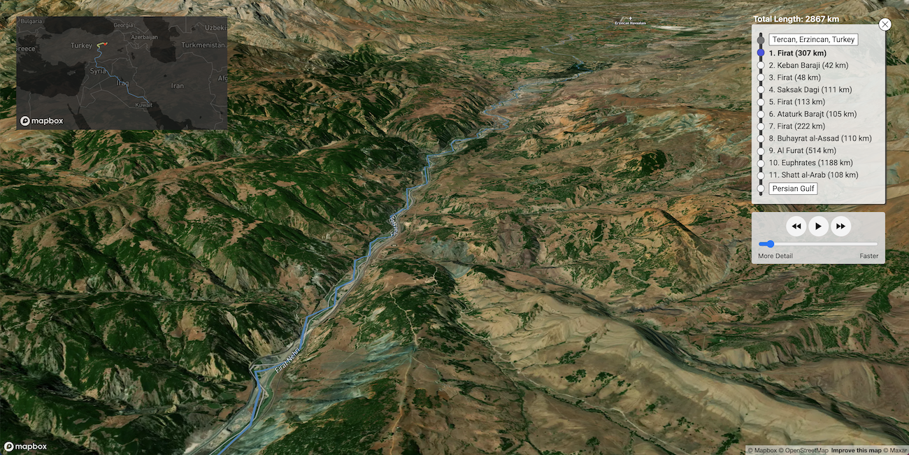
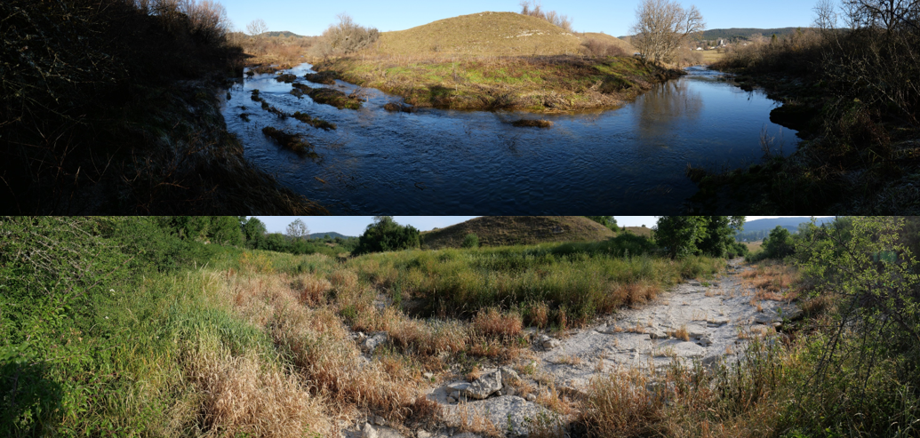
    The Evros/Meriç/Maritsa has its source in the Rila mountains. It runs for 310 of its 528 kilometers through Bulgaria, with the final 210 kilometers forming a border, initially between Bulgaria and Greece, and then for the last 192 kilometers between Greece and Turkey before reaching its delta and emptying into the Thracian Sea in the Aegean. The river is fast, with a mean annual flow rate of 103 cubic meters per second (a rate which can increase twofold between December and April). Its course flows over sandy and malleable soil, and annually discharges approximately 3.2 million tons of sediment and 9.5 billion cubic meters of freshwater into the sea.
    This results in frequent erosion that alters its banks. Capricious shifts of the river produce islands of stranded land; there are expanses of “Turkish” earth on the “wrong” side of the river, and elsewhere, land has been ceded by the river to Greece. These stranded territories are also points where fatalities become concentrated. Pavlos Pavlidis, coroner at the University Hospital of Alexandroupolis, capital of the Evros prefecture, and Maria-Valeria Karakasi have identified a particular parcel of land near Feres, the entry point to the Delta, as the location where seventy-two bodies were recovered between 2000 and 2014. This is also where refugees were recently directed by geographers aligned with Turkish authorities,

    and where a young man from Aleppo, Muhammad al Arab, was shot dead by Greek soldiers standing inside the dry river bed of the 1926 border, which now acts as little more than a trench. Within the above calculations of river flow and sediment transportation is concealed a deadly politics of bordering that incorporates the full spectrum of the Evros’s hydrology and manipulates the ambiguities produced by rivers.

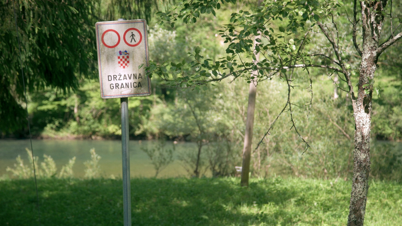
    The river’s movements occupy a central role in the territorial disputes between the riparian states of Bulgaria, Greece, and Turkey, and compound what is already a militarized terrain. Due to these shifts, and the river’s own agency, many have considered rivers as inadequate political boundaries. Donaldson words it thus: “the presence of water makes a boundary river unstable, forceful, and risky; incompatible with the legal fiction of a fixed boundary line that would prefer the stability of land over the dynamism of water.”
    This instability lies behind the fantasies of territorial control implied by the international committee assembled in 1926 with the task of determining the precise course of the border between Greece and Turkey at the end of the Ottoman Empire.The 1926 committee, headed by Dutch colonel J. Backer, deemed that the border follow the median line between the banks throughout the course of the river, or its main “branch,” when the river splits. The border was marked with red ink on ten maps that were attached as annexes to the protocol, and the first twenty-six demarcation “pyramids” were installed. Delimited in such an inflexible way, like many river borders, it could not respond to shifts in the median line and changes in the course of the river. Instead, the demarcation of the protocol fixed the river in time and to an abstract line. Consequently, efforts to enforce the demarcation of the border have long been hampered by the agency of the river itself. As early as 1965, markers installed to designate part of the border along the Evros/Meriç by a joint Greek-Turkish committee were quickly carried away by the river. Similarly, in 2015, parts of the fence were carried away by flood waters released from the Ivaylovgrad dam. As recently as October 2017, Turkish authorities dug trenches underneath the fence to prevent flooding.

    There is now almost 100 years of geomorphological variation between the drawn border and the current course of the river. Islands that used to be there are no longer; banks have moved and canalizations have directed the river in divergent ways. Two rivers and two borders exist at the Evros/Meriç: the cartographic border of the old median line (featuring now almost unmoving oxbow lakes) and the water of the new trespass line. It comes with little surprise then that stabilizing the river banks to the 1926 condition has been a concern of both Greece and Turkey. Since 1936, the two countries have made efforts to draft plans for common flood defense, most notably the study undertaken in 1953 by the Chicago-based Harza Engineering Company. None of these plans were fully implemented, and after the 1970s, bilateral communication ceased for decades.

    In addition to the proposal of the fence in 2011, the Hellenic Army General Staff planned an unfulfilled project to dig a “120-kilometer-long, thirty-meter-wide, and seven-meter-deep” “moat.”

    Officially an “anti-tank trap” functioning primarily as a defense against Turkish invasion, in the context of increased crossings in 2011, the “moat” would have only been a further technical barrier for border crossers.

    Where rivers appear at first glance as “natural,” they are, to greater and lesser extents, the result of centuries of small and large-scale engineering interventions. In Stefan Helmreich’s concept of “infranature,” second nature—that which is always produced as socio-technical—is “folded” back into first or organic nature.
    What appears as “natural” or “organic” is therefore actually a mask for the production of techno-natural infrastructures. Helmreich echoes a famous passage in Michel Serres’s The Natural Contract where he describes the birth of geometry emerging from the calculations of Nile floods. Out of the “chaos” and “disorder” of flood events, Serres proposes that measurements made by surveyors, for irrigation purposes, reordered nature to give “it a new birth into culture.”

    Such culture, however, may itself produce violent effects. The measurements that reorder the river waters of the Evros are born into a culture that takes the form of a hybrid military-natural assemblage.

    Understanding the often intentionally ambiguous calculations of infranature in its combative applications helps to clarify how rivers are technologized through overt human interventions, such as dams and other large engineering projects, as well as in less overt ways. Rivers and their flows respond to assemblages of smaller scale and almost invisible interventions or those that occur far up river, like the opening of a dam. In these ways, the very speed at which water travels, or the amount of sediment that accumulates in the muddy delta, are part of the measurements of the infrantural technology of the arcifinious river. In these border environments, the river itself is potentially armed and dangerous.

    The river and its imagined doubling as a moat instrumentalizes the already treacherous route for asylum seekers beyond the scale of a “deterrent” into an engineered space unconcerned with fatalities. Stepping back from the Hellenic Army General Staff’s imagination, the Evros already performs the arcifinious role of a moat at the EU’s fluvial frontier. The drawing of a fixed, yet imaginary line along the central course of the river effectively produced the river as a frontier, whereby its movements and muds become spaces where sovereign territorial imaginaries are projected with horrifyingly real effects.

    3. Flood

    The risk of major flood events has long been one of the primary transboundary concerns in the Evros/Meriç/Maritsa. Such events have increased in frequency over the last twenty-five years, leading to a once in a thousand-year flood in 2005, severe events in 2006, 2007, 2011, 2014, and 2015, and a “state of emergency” announced by the Greek Government in March and April 2018.
    Flooding in the region is closely tied to the politics of hydro-electric infrastructure. The majority of large dams and reservoirs in the basin are concentrated on Bulgarian territory (as many as 722), while Turkey has built sixty, and Greece just five (mainly for irrigation purposes, as opposed to energy production). Flow variability is central to many transboundary agreements whereby upstream riparian nations either force or allow downstream riparians to adapt to seasonal changes in both wet and dry conditions.

    This is a concern for hyrdrodiplomatic relations between Greece, Turkey, and Bulgaria.

    When a tri-lateral working group met in October 2006 in Alexandroupolis, Turkey made a written demand, supported by Greece, that the reservoir storage capacity of large dams situated on the Ardas tributary in Bulgaria be regulated to “minimize water discharges downstream and reduce flow at Edirne,” a densely populated area, near to the border fence, and a major confluence where the Ardas and another tributary, the Tundzha, meet the Evros/Meriç/Maritsa. The Bulgarian delegation refused to respond and cancelled future working groups. Bulgaria is resistant to such regulation because of the role that the private sector plays in managing hydro-electric infrastructure.
    To maximize energy productivity and profits, their primary interest is to maintain the highest possible water level in the dam reservoirs all year round. Under previous conditions, this would have been in direct opposition to the interests of the downstream nations who want to regulate reservoir storage in wet seasons so they have the capacity to accommodate potential increases in volume that risk overtopping dams and result in flooding. The events of the past month, however, show that within the context of Bulgaria’s entrance into the EU in 2007, upstream storage of high levels of water is also part of military contingency planning to flood the valley and safeguard what is now a common European frontier.

    Recent attempts at hydrodiplomacy in the region include the 2016 “Joint Declaration Between the Government of the Hellenic Republic and the Government of the Republic of Turkey” signed by Prime Ministers Alexis Tsipras and Ahmet Davutoglu.

    This agreement incorporated multiple political and hydrographical issues that fold onto the frontier, including a Joint Action Plan to “stem migration flows,” with the implied proviso that Greece will support Turkey in EU visa liberalization dialogue. While this proviso has since been forgotten, the lubrication of one form of movement was unambiguously exchanged for the curtailment of another. This is followed by a section on flooding, acknowledging the damage caused each year and expressing a joint commitment to adhering to the centralized European Water Directive. As downstream nations, Greece and Turkey agreed and welcomed faintly veiled “goodwill and cooperation” from the “other relevant parties,” intimating Bulgaria, to whom they direct much of the blame.

    The overlaps between a river that regularly floods and a territory where border crossers are at the mercy of systematic violence resonates troublingly with nationalist media and governmental rhetoric of “flows,” “floods,” or “surges” and the “stemming” of migrants.”
    Naturalizing metaphors such as these emerge wherever border regimes are discursively or materially constructed to ensure the illegality of movement across borders, and in doing so, racially “other” border crossers. Indeed, hydrologic metaphors are evoked to draw a distinction between those who do not belong and those who do within a sedentary notion of territory. In light of the events of March 2020, the material movement of water out of place is not perceived as a threat that must be contained to prevent it seeping into discourses that legally and culturally ground the nation-state. Instead, the movement of these waters are deployed in the very efforts to exclude others from the space of the nation-state.Joint Operation Poseidon Land, EU border agency Frontex’s Evros operation, began in 2011. The name conjures a pathologic mythology, casting border crossers as mortals committing the hubris of seeking refuge in Europe, while Frontex claims the role of chastising deity. Here Poseidon, god of both the sea and rivers, intervenes at the land-water divide. In mythology, where his trident struck, land quakes and flooding and drowning ensues. Echoing a crude sketch of the hydrologic cycle, Operation Poseidon Land transposes border violence in liquid form from the Aegean—where Operation Poseidon Sea is enacted—to the headwaters of the Evros/Meriç/Maritsa and back down along its course. The rumored intentional flooding of the valley from the Ivaylovgrad dam brings Frontex’s troubling mythological sensibility into reality.

    4. Anachoma

    A week before the flooding made the headlines, and a day after Muhammad al Arab’s killing, the European commission president, Ursula von der Leyen visited Evros, along with three EU leaders and the Greek Prime Minister, Kyriakos Mitsotakis. Following the visit, they gave a joint statement in which der Leyen thanked Greece for being Europe’s aspida, using the Greek word for “shield” (ασπίδα).

    Der Leyen’s choice of vocabulary uncannily echoes local military discourse, in which the region is often called Greece’s ανάχωμα (anachoma), or embankment, against Turkish invasion, and more recently against asylum seekers. The landscape of the Evros/Meriç/Maritsa is entirely sculpted to either contain or facilitate movement, be it of military personnel, people, or water. The berm, a versatile and ambiguous military-ecological technology, is the physical embodiment of the ανάχωμα. There are multiple types of berms, each of which is designed to perform distinct functions. There are surpassable/summer berms, main berms, tertiary berms for flood defense, raised rail lines and roads enabling movement during flood periods, irrigation, and, most explicitly in the delta, anti-tank installations. A hierarchy is designed into the system of flood control to allow water, armies, and people to penetrate the frontier space to varying degrees.

    The military imaginary of Evros as an ανάχωμα also refers to a more nuanced politics of demographic engineering. The delimitation of the border in the 1920s coincided with the exchange of populations between Greece and Turkey, a process which created imagined communities that the river division helped crystalize. The process intended to produce a Greek Christian population along the border as a demographic buffer—or embankment—against invasion. This began with the transfer of Greek-speaking populations from what became Turkish territory on the shores of the Aegean and the Anatolian peninsula, as well as Pontic Greeks from the shores of the Black Sea. In return, Turkish-speaking and other Muslim populations from Greek territory were moved to Turkey, although significant minority populations still remain in western Thrace. In the century since, Turkish, Pomak, Bektashi, and other Muslim minorities in western Thrace have been the focus of multiple marginalizing practices. A system of checkpoints (barres) was put in place in 1936 to isolate these communities, the last of which were removed as recently as 1995.
    When we visited the Bektashi villages of Roussa and Goniko in Evros, we saw the check point still standing, an abandoned yet powerful reminder of the state as an ambient presence.

    As embankments of wet earth, berms are concentrations of these politics of demographic engineering and territorial control. They are ground engineered in excess. They are routes of control through the floodplain for the police, military, and local farmers, and they figure within the imaginary of the moat as obstacles for invading forces. The berms reveal the border regime’s deployment of the environment as defensive “infranatural” technology.

    Corresponding to the engineered limits of the floodplain, berms are often placed along the edge of the military buffer zone that runs along the Greek side of the Evros border, also known as ZAP (Zoni Asfaleias Prokalypsis). As human rights reports have been claiming for years, where the floodplain/buffer zone broadens, the river becomes a site where human rights violations occur. These include the failure to rescue and illegal pushbacks of border crossers back to Turkey.
    A case on May 8, 2018 involving a group of fourteen people attempting to cross during a flood event speaks directly to the overlapping of flooding with the operations of the border. The attempt failed and resulted in one fatality. Once the group returned to Turkey, they attempted to contact Greek authorities with a picture of the ID card and the GPS location of the body. Greek police stated that the flooding was too severe to attempt a recovery, and over the next few days, no confirmation of the recovery of the body was received. In other examples, the police have refuted the possibility of pushbacks because the water is too high or the geomorphology makes it impossible. In this way, the behavior of water in excess is co-opted as an obviatory device; a mask in the construction of denial. The flood is an alibi for border violence. Consequently, the berm infrastructure marks the limit of the flood and acts as a container for this riverine geography of exception.

    5. The Delta

    The Evros Delta, where the river meets the Thracian Sea, covers a surface area of 111,937 square kilometers. A protected conservation area designated as a wetland of international importance by the 1971 Ramsar treaty, the delta’s saline waters, ponds, and islands are home to a number of migratory bird species. Since last month, however, it has hosted a different kind of migration, with army and police units operating side by side with local, self-proclaimed “frontiersmen,” “guardians of the border,” and hunting clubs from all over Greece arriving to prevent what they understand to be an “intrusion” of “illegal aliens” (“lathrometanastes”) into Greece. Joining them are far-right and neo-nazi militants from Europe and the US who have flocked there to demonstrate their support, and “safeguard Europe’s borders.” Showing little regard for human life, they describe their operations as “hunting” for refugees. The ongoing dehumanization of asylum seekers using both language and physical force permeates the region. Detainees in the recently exposed border guard center at Poros, have described guards treating them “like animals.”
    The violent events of the past month, including the killings of Muhammad al Arab inside the Evros delta and Muhamad Gulzar in the Karaağaç Triangle, as well as the reports of the opening of the Ivaylovgrad dam, are punctuating moments that bring to the fore the slower environmental processes mobilized against asylum seekers at the border. The Evros catchment basin is currently a densely braided space of border violence and death, incorporating military personnel, nationalist and neo-nazi paramilitaries, local farmers and hunters, as well as the very ecology of this deltaic marshland, such as temperature and meteorological conditions. Indeed, rather than being a “natural” border, the Evros is an exemplary case of a borderized nature, where environmental elements, which are not deadly on their own, are made deadly by forcing people to traverse them under treacherous conditions. We have spoken with asylum seekers who have described the fog that hangs above the Evros. Fog, like clothes sodden from swimming across the river, and combined with freezing winter temperatures, contribute to the threat of hypothermia for border crossers, which, after drowning, is the second highest cause of death at Evros. As reported in the media, paramilitaries who have been recently drawn to the area to hunt people who cross “at night and in the fog,” are transposing the old Nazi directive for disappearing bodies “Nacht und Nebel” (“Night and Fog”) onto the Evros Delta.Through the waters of the river, amongst the impacted earth of the berms, and under the veil of the heavy airs of teargas and pesticides, complex forces are deployed and emerge from the fog of the Evros/Meriç/Maritsa. Understanding the complexity of the river as a weaponized border ecology is crucial to reveal the ongoing and intensifying violence that unfolds across different scales in this region. To confront the far-right that is currently assembling its forces rhetorically, environmentally, and in person in the Evros delta and all along the fluvial frontier, and to counter the obfuscating tactics long deployed by the police in their use of the river as alibi, requires understanding how this border is constructed. When considering the Evros border, we must learn to perceive the entire floodplain as a border technology. This, in turn, involves striving to see the river as a spectrum, from freezing fog in the valley, dew in the field, and mud in the floodplain as clearly as it sees water flowing between the riverbanks themselves.To assist migrants in defending their rights, and to resist the far-right seeping out of border regions into increasingly xenophobic societies, the very concept of “nature” needs to be reframed to encompass the ways it is deployed within the military imaginary of borderized environments. Practices must be developed to perceive how border regimes harness environmental processes. Such practices reveal the varying watery states of the Evros/Meriç/Maritsa as what they are: the riverine arsenal of a deadly defense architecture. The border regime operates as an expanded or “dispersed” territorial technology: an entire region designed as a violent ανάχωμα.

    https://www.e-flux.com/architecture/at-the-border/325751/weaponizing-a-river

    #weaponization #Evros #asile #migrations #réfugiés #frontières #Thrace #Grèce #Turquie #architecture_forensique #Forensic_Architecture #rivière

    • GEOGRAPHY OF EVROS/MERIÇ RIVER PUSHBACKS

      Across January, BVMN collected testimonies
      documenting pushbacks over the Evros/
      Meriç river on the Greek-Turkish border,
      impacting over 500 people-on-the-move.
      These incidents validate a pattern identified
      by BVMN of Greek authorities using small
      islands in the river to stage pushbacks, often
      leaving groups stranded there for indefinite
      periods. Beyond inhumane treatment –
      pregnant women have been left without food,
      water or shelter – several reports indicate
      that people are placed at direct risk of
      drowning (see 8.4) in the river.
      Ironically, Greece has cited flooding as a
      reason not to mount rescue operations or
      recover the bodies of those who have
      drowned, while using the riverʼs water level
      and challenging geomorphology to refute the
      possibility of pushbacks.
      One testimony (see 8.5) offers a compelling
      example of the dangers associated with this
      practice. It describes how eight North African
      men were driven into the middle of the Evros
      river and ordered to jump in. With “water
      reaching their chests ”, the men were forced
      to wade to an island from where they could
      swim to Turkish shores. While attempting the
      crossing, however, one man was swept away
      by the overwhelming current, only managing
      to survive by grabbing onto a fallen tree.
      Witnessing this scene, the remaining men on
      the island feared to cross as they could not
      swim. With soaking wet clothes, they were
      stuck there for three days in sub-zero
      temperatures, until they were eventually
      retrieved by Greek police and pushed back to
      Turkey.
      Perhaps most unsettling is that the officers
      allegedly watched this scene unfold and took
      over 72 hours to intervene. Hypothermia is
      the second highest killer of transit groups in
      the Evros region. Reminiscent of the triborder
      area between Bulgaria, Greece and
      Turkey, which is being used to stage indirect
      chain pushbacks, this phenomenon
      represents a weaponization of geography, or
      as one commentator eloquently wrote, ʻa
      form of hybrid border violence that explicitly
      incorporates the river ecology itselfʼ.

      https://www.borderviolence.eu/balkan-region-report-january-2021
      –-> pp.7-8

  • Manifested Stories. An Alternative Narrative to the Urban-Frontier Myth

    Rebecca Pryor traces the history of the revitalization of the Bronx River, illustrating an alternative narrative to the urban-frontier myth—one that centers Black and Brown communities and is community-generated.

    At the beginning of the film The Last Black Man in San Francisco (2019), which takes place in the not-so-distant future, a curbside preacher asks passersby why San Francisco is only now cleaning the Bay when residents have lived by its toxicity for decades. The cleanup is not for us, he yells, our neighborhood is “the final frontier for manifest destiny.”

    The preacher’s reference to manifest destiny is the urban-frontier myth at work. Originally theorized by geographer Neil Smith, this myth shows how American frontier language (“frontier,” “pioneer,” and “Wild West”) is used to justify gentrification and displacement. Smith names the myth to pinpoint what’s lurking behind the language: “the gentrification frontier is advanced not so much through the actions of intrepid pioneers as through the actions of collective owners of capital. Where such urban pioneers go bravely forth, banks, real-estate developers, small-scale and large-scale lenders, retail corporations, the state, have generally gone before” (Smith 1996). Through frontier language, gentrification is understood as rugged individualism instead of a phenomenon rooted in social, political and economic forces.

    The myth of the urban frontier reveals the power that stories have over place. The American frontier has always relied on complex justification narratives of white-settler colonialism—taking land and continuing to live on it requires stories about hate, fear, obsession and erasure (Tuck and Yang 2012). The same is true for the story created by urban-frontier language—longtime Black and Brown residents are erased, neighborhoods are devalued and then “discovered” through gentrification. But this is not the only kind of story. Another kind of story, what I am calling an “alternative narrative,” centers Black and Brown communities and can begin to appropriate urban spaces through collective land stewardship.

    Alternative narratives are formed by community-generated stories of place that manifest spatially. Whereas the frontier myth reflects a belief system that justifies erasure and individual profit, alternative narratives encourage the opposite—solidarity and collective ownership. One such alternative narrative is the story that environmental justice leaders created around the Bronx River.
    The Bronx River story

    The revitalization of the Bronx River has all the seeds of a great story. Those involved have mythical accounts of hauling cars out of the water and building parks from trash heaps. Many will talk about the importance of collective power and unexpected partnerships. Several say that they were lost until they “found” the river.

    Also, it’s a river. Rivers and most American waterways are uniquely common spaces. Unlike public parks and plazas, waterways are not owned by a city, state, or federal agency; they are governed by English Common Law, which secures the water as a public highway. The law creates spaces that, in some ways, can remain outside the context of American land ownership.

    The Bronx River story has three acts: the Upper River, the Lower River, and their unification. Act I begins in 1974 when Bronx resident Ruth Anderberg fell in love with a northern portion of the upper river, which runs from West Farms Square to 233rd Street. Once she realized that this was the same river as the one covered in trash at West Farms, she began a public cleanup project, enlisting police chiefs, local residents and friendly crane operators. Filled with everything from cars to pianos, the river was part archaeological site, part landfill. Anderberg’s efforts eventually turned into the Bronx River Restoration Group, a nonprofit that led restoration efforts and a youth workforce program until the late 1990s (DeVillo 2015).

    Act II’s star, the Lower River, which runs from West Farms Square to Soundview, was overshadowed by the catastrophic impacts of government disinvestment in the South Bronx (Gonzalez 2006). One interviewee who lived in the Bronx in the 1970s said that, “as a teenager, I was ashamed of living in the Bronx […] we became the symbol of urban decay, we became everything that can go wrong in a city.” Media and popular culture, like the 1981 blockbuster hit Fort Apache, perpetuated the urban-frontier myth, showing the South Bronx as both terrifying and alluring, rather than as a neighborhood neglected by the government.

    In the following decades, community-based organizations like Banana Kelly and The Point CDC spearheaded community investment and provided critical social services. Vacant lots became community gardens and a movement of community reliance grew. The river, however, remained cut off by industrial lots.

    Act III opens with city and federal investment in the river. The Parks Commissioner dubbed 2000 the “Year of the Bronx River” and committed federally allocated restoration funds to the river’s revitalization. NYC Parks seed grants helped develop two community-designed parks, connecting the South Bronx to its waterfront. Once there was waterfront access to the Lower River, organizations from both sections formed the Bronx River Alliance. From early on, the Alliance led creative community events to bring attention to the river.

    Today, the Bronx River is a physical manifestation of community power. The same interviewee who had said she was ashamed of the Bronx as a teenager described “finding” the Bronx River decades later with her children. “You have to teach new people who come here who might think the river is dirty,” she said. “You have to show them the restoration efforts. This river is used for community building. This river is about community.”
    A visual story: community design and power

    The parks conceived by Bronx residents and activists reflect a story of collective power and appropriation of space. Concrete Plant Park (CPP), a waterfront park designed by community members, reflects how the alternative narrative is also ingrained in its design choices.

    In the early 2000s, Youth Ministries for Peace and Justice (YMPJ) used NYC Parks’ $10,000 seed grant to create a youth-led park design for an abandoned concrete plant. As part of their design process, they visited a waterfront park in Westchester County (immediately north of New York City). They saw that the park in this whiter and wealthier community invited people to the water’s edge with green space, whereas most of the parks in the Bronx had asphalt. Their design choices reflected a choice to honor their history and look towards the future. They incorporated passive recreation, a boat launch, and the retention of the concrete plant structures as a reminder of their past. As one interviewee from YMPJ described his experience of CPP, “the concrete plant acts as a visual story for the park: the story of repurposing, the story of community power, the story of what could be done.”

    The concrete plant relics, park design, and ongoing community-led programming are a visual representation of an alternative narrative about how to claim space. This is not a simple story. CPP was not only metaphorically appropriated; the site was removed from city auction and transferred to the Parks Department as a permanent park. And CPP was not created by a design survey and a neighborhood campaign alone—the transformation of CPP has taken over 20 years and is the result of community advocacy, citywide partnerships, and federally secured funding. Similar representations of community power and creative partnerships are found in parks throughout the lower portion of the river, from #Starlight_Park to #Hunts_Point_Riverside_Park.

    Interconnected transformations: people and place

    Interviewees born and raised in the Bronx consistently spoke about the transformation of themselves and the Bronx River as part of the same story. As urbanist David Harvey states, “the right to the city is far more than the individual liberty to access urban resources: it is a right to change ourselves by changing the city” (Harvey 2008).

    An interviewee in her late twenties said, “I didn’t know anything about the Bronx River growing up, except that my grandfather’s brother died on it in the late ’70s. For me and my family, it was like, you don’t go to that place, it’s dangerous.” During college, she wanted to leave the Bronx in order to study the environment, but she became involved with the Bronx River Alliance and its stewardship efforts. When she took her grandfather to see the river, she said that “he was so amazed by the transformation. And I think part of this whole transition in me has been about changing the perception of those who are close to me who have always said, ‘No, you don’t go there.’”

    There are a couple of layers to this anecdote. First, this interviewee is young in the context of the Bronx River story. Without the previous decades of work spent appropriating space and establishing stewardship institutions, she may have left the Bronx to feel professionally fulfilled. Second, the story grew in a way that made room for her. It shifted from the manifestation of a frontier narrative placed on the Bronx—one of fear, danger, and otherness—to an alternative narrative that was generated by the people who lived there.
    A search for justice stories

    After the preacher in The Last Black Man in San Francisco questions the intended beneficiary of the Bay’s environmental cleanup, we watch as our protagonists, two young Black male San Franciscan friends, try to lay claim to their childhood home and, ultimately, to their narrative of belonging in San Francisco. The movie starts by satirizing the all-too-common story of green gentrification, where the cleanup of a toxic site is the harbinger of neighborhood displacement, and ends by illustrating the lonely battle of a Black man attempting to prove home ownership through his story alone.

    The Bronx River story, so far, is different. The river’s restoration was fueled by the incumbent community and its ongoing grassroots revitalization reaffirms their presence. Anchor institutions have helped to employ residents and keep them in the borough, if they want to stay there. Countless collaborative partnerships at the federal, city, and local level have enabled the transformation of the river. The Bronx River story is also not over. New waterfront developments are cropping up along the river as market-rate housing blooms in nearby gentrifying neighborhoods. Banana Kelly, The Point CDC, and Youth Ministries for Peace and Justice are now part of a coalition of groups challenging the city’s rezoning of the Southern Boulevard in the South Bronx. What happens next is the cliffhanger.

    https://metropolitics.org/Manifested-Stories.html

    #Bronx_river #Bronx #renaturation #revitalisation #rivière #gentrification #USA #Etat-Unis #narrative #récit #USA #Etats-Unis

  • 3ème #Apér-EAU_scientifique, 01 février 2021, 18h : « Pour une démarche participative dans les risques environnementaux » par Anne-Peggy Hellequin et Caroline Rufin-Soler
    https://reseaux.parisnanterre.fr/3eme-aper-eau-scientifique-01-fevrier-2021-18h-pour-une-demarc

    L’association Rés-EAUx vous convie à son 3ème Apér-EAU scientifique de la saison 2020-2021, le lundi 01 février 2021 à 18h. Nous aurons le plaisir d’accueillir Anne-Peggy Hellequin, professeure de géographie à l’université Paris Nanterre, et Caroline Rufin-Soler, maîtresse de conférence … Lire la suite

    #Apér-EAUx_2020-2021 #Grand_bleu #Khauraha #Kon_Kam_King #pêcherie #rivière #thon #Vouiller

  • Keep Out... Come Again. The underbelly of American-styled conservation in the Indian Himalayas.

    IN DECEMBER, THE ROAD leading to the #Tirthan_Valley entrance archway of the #Great_Himalayan_National_Park (#GHNP), a #UNESCO World Heritage site in India’s mountain state of Himachal Pradesh, is a potholed mudslide: For miles, a fleet of excavators and tunnel-boring machines are lopping and drilling the mountains to widen and extend the highway. Most of the traffic passing through a big, dark tunnel blasted through the mountain is headed to Manali — the mass-tourist hub of the Western Himalayas, about an hour’s drive farther north.

    My partner and I pass through the archway and weave the motorcycle along a cliffside road into the gorgeous, narrow valley. Villages and orchards dot the ridges. The first snow is melting off the roofs, and far below the Tirthan River runs free and fast. This is still the off-beaten path. But around every turn, we see signs that development is on the rise. Guesthouses, campsites, cottages, hotels, and resorts are sprouting up outside the park’s boundaries. Trucks carrying construction material drive traffic off onto the shoulder. On the opposite ridge, a new helipad access road is being carved out. The area appears to be under construction, not conservation.

    It seems that by putting this once little-known national park on the global map, conservationists have catalyzed a massive wave of development along its border. And ecotourism, though ostensibly a responsible form of development, looks over here, as one researcher put it, more like “old wine in a new bottle.”

    In the two decades since it was formed, the park has displaced over 300 people from their land, disrupted the traditional livelihoods of several thousand more, and forced yet more into dependence on a risky (eco)tourism industry run in large part by outside “experts.” In many ways, the GHNP is a poster child of how the American national park model — conceived at Yellowstone and exported to the Global South by a transnational nexus of state and nonstate actors, continues to ignore the sociopolitical and cultural realities of a place. As a result, protected areas around the world continue to yield pernicious impacts on local communities, and, to some extent, on the local ecology as well. It also raises the question: If protecting one piece of land requires moving its long-time human residents out, developing adjacent land, and flying in tourists from around the world — what is actually being conserved?

    IN THE EARLY 1980s, at the invitation of the Himachal government, a team of Indian and international wildlife biologists led by a British researcher named Tony Gaston surveyed the Western Himalayas for a possible location for the state’s first national park. The state government had been eyeing the Manali area, but after a broad wildlife survey, Gaston’s team recommended the Upper Tirthan and Sainj valleys instead.

    The ecosystem was less disturbed, home to more wildlife, and thus had “excellent potential for attracting tourists”— especially foreign tourists — who might constitute both a “substantial source of [park] revenues” as well as “an enormous input to the local economy,” the team’s report said.

    The proposed 754.4-square-kilometer park included the upper mountain glacial and snow melt water source origins of the Jiwa Nal, Sainj Tirthan, and Parvati rivers, which are all headwater tributaries to the Beas River and subsequently, the Indus River. Given its location at the junction of two of the world’s major biogeographic realms — the Palearctic and Indomalayan — its monsoon-fed forests and alpine meadows sustain a diversity of plant, moss, lichen, bird, and mammal species, many of which are endemic, including the Himalayan goral, blue sheep, and the endangered western Tragopan pheasant and musk deer.

    The park’s boundary was strategically drawn so that only four villages needed to be relocated. But this glossed over the problem of resource displacement. To the northwest, the proposed park was buffered by high mountain systems that include several other national parks and wildlife sanctuaries, but the land in and around its southwest boundary was home to about 150 villages with a total population of at least 11,000 people, all of whom were officially dispossessed of the forests they depended on for centuries when the Indian government inaugurated The Great Himalayan National Park in 1999. These villages are now part of a 265.6-square-kilometer buffer, or so-called “ecozone,” leading into the park.

    A large majority of these families were poor. Many of them cultivated small parcels of land that provided subsistence for part of the year, and they relied on a variety of additional resources provided by the forestlands in the mountains around their homes to meet the rest of their food and financial requirements. That included grazing sheep and goats in the alpine meadows, extracting medicinal herbs that they could sell to the pharmaceutical and cosmetics industry, and collecting gucchi, or morel mushrooms, that fetched high prices in international markets.

    “IN THE INDIAN CONTEXT, the notion that you can have a landscape that is pristine and therefore devoid of humans is an artificial creation,” says Dr. Vasant Saberwal, a wildlife biologist and director of the Centre for Pastoralism, an organization based in Gujarat state that aims to enhance our understanding of pastoralist ecosystems. “India has [long] been a heavily populated country. So, when you think of alpine meadows at 15,000 feet above sea-level, they have been used by pastoral communities for several hundred years. You cannot now go into those landscapes and say we want a pristine alpine meadow. There’s no such thing.”

    In keeping with the lingering idea, tracing back to early American conservationism, that pastoral societies destroy their own land, the Gaston team’s original report claimed that firewood collecting, hunting, and especially overgrazing, were degrading habitat within the area. It recommended a ban on grazing and medicinal plant collection in order to maintain the park’s biodiversity.

    But Saberwal’s research shows that grazing practices in the park’s high alpine meadows — which constitute almost half the park’s area — were likely necessary to maintain its high levels of herb diversity. Before the area was closed off to people, traditional herders of the Indigenous Gaddi tribe would travel up to the alpine meadows with about 35,000 sheep and goats entrusted to them by individual families, and graze them in these meadows for six snow-free months from April through September.

    “So, when you talk to people and suggest to people that their use of the park leads to degradation, they say that we have been using these resources for the past 150-200 years,” he says. “They say, if our presence here has been such a threat, then why would there be biological diversity here?”

    Saberwal’s findings are consistent with reams of scholarship in recent years documenting how local and Indigenous communities, without external pressures, live convivially with nature.

    That is not to say that external pressures aren’t impacting the region. There has definitely been an uptick in morel and medicinal herbs extraction from the park area, especially since the early 1990s when India “liberalized” its economy. Yet today, without adequate enforcement, it remains unclear just how much the park actually helped curtail extraction of these herbs or instead just forced the market underground.

    Other threats include poaching, human-wildlife conflicts, and hydropower development. Ironically, a 10-square-kilometer area was deleted from the original map of the GHNP for building of a hydro-power project, underscoring a typical approach towards conservation “wherein local livelihoods are expendable in the interests of biodiversity, but biodiversity must make way for national development,” Saberwal says.

    India’s Wildlife Protection Act, which prohibits all human activities within a national park, does recognize people’s traditional rights to forest resources. It therefore requires state governments settle or acquire these rights prior to finalizing a new national park’s boundaries, either through financial compensation or by providing people alternative land where such rights can be exercised. But India’s record of actually honoring these rights has been sketchy at best. In GHNP’s case, the state chose to offer financial compensation to only about 300 of the 2,300 or so impacted households, based on family names listed in a colonial report with census data for the area dating back to 1894. It eventually provided the rest of the villagers alternative areas to graze their livestock, but this land was inadequate and nutrient-poor compared to the grasses in the high alpine meadows. Only a handful of families in these villages still have sheep and goat herds today.

    Saberwal, and many mainstream conservationists, says there is an argument to be made for allowing villagers into the park, and not only because it supports their livelihoods. “The presence of people with a real stake in the biological resources of the park can also lead to far greater levels of support for effective management of the park, including better monitoring of who goes into the park, for what, and at what times of the year. Poaching could be more effectively controlled, as could the excessive extraction of medicinal herbs,” he says.

    DESPITE STIFF LOCAL RESISTANCE, the forest department — with support from an international nonprofit called Friends of GHNP, as well as the World Bank, which chipped in a $2.5 million loan — developed an ecotourism industry in the area to help local communities adapt.

    Eco-development, of course, is the current cool idea for making exclusionary conservation acceptable. On paper, it requires community involvement to create “alternative livelihoods” to reduce locals’ dependence on a park’s resources. So, with the support of Friends of GHNP, the forest department helped form a street theater group. It developed firewood and medicinal herb plantations in an effort to wean villagers off of foraging for these the park. A women’s savings and credit collective called Sahara was set up to produce vermicompost, apricot oil, and handicrafts. The Forest Department also handed out “doles” — stoves, handlooms, televisions, pressure cookers — what Mark Dowie, in his book Conservation Refugees, calls “cargo conservation,” or the exchange of commodities for compliance.

    Yet, the project was mired in corruption and mismanagement. The male director of the women’s collective, for instance, was discovered to be siphoning off the collective’s funds. Meanwhile, local ecodevelopment committees set up to coordinate expenditure on livelihood projects were run by the most powerful people in the villages, usually upper-caste males of the devta (deity) community, and chose to spend the money on things like temple and road repairs. According to a 2001 study of the ecodevelopment project, 70 percent of the funds were spent on infrastructure initiatives of this kind. Much later, in 2002, in an attempt to distance itself from the program, the World Bank concluded ecodevelopment had left “very little or no impact … on the ground.”

    In 2014, the park, along with the adjacent Sainj and Tirthan wildlife sanctuaries, was designated a UNESCO World Heritage site, again in spite of more protests from the impacted local communities. Friends of GHNP wrote the application.

    If creating the park cracked the door to development in the Tirthan Valley, minting it a UNESCO World Heritage site flung it wide open.

    On the economic front, it’s certainly true that the influx of tourists has injected more money into the Tirthan Valley than ever before. And it’s true, too, that many locals, the youth especially, are excited, or at least hopeful, that the industry will improve their lives and alleviate poverty. But on the whole, locals are losing opportunities to outside entrepreneurs who come with deeper pockets, digital marketing savvy, and already established networks of potential clientele.

    “That kind of investment and marketing involvement is difficult for locals for figure out,” says Manashi Asher, a researcher with Himdhara, a Himachal-based environmental research and action collective. “Basically, what many locals have done instead, is circumvent local ecotourism policies by turning their properties into homestay or other kinds of [tourist] lodgings and leasing them out to outsiders to run.”

    Though there are no official estimates yet, there’s a consensus among locals that outsider-run guesthouses have already cornered a majority of the valley’s tourism revenue. “City-based tourism operators are licking out the cream, while the peasantry class and unemployed youth earn a pittance from the seasonal, odd jobs they offer,” Dilaram Shabab, the late “Green Man” of Tirthan Valley who spearheaded successful movements against hydropower development on the Tirthan river, wrote in his book Kullu: The Valley of Gods.

    When I read this quote to Upendra Singh Kamra, a transplant from the northwestern state of Punjab who runs a tourism outfit for fishing enthusiasts called Gone Fishing Cottages, he emphasizes how, unlike at most properties, they don’t lay off their local staff during low season. Some have even bought motorcycles or cars. “Logically, you have nothing and then you have something and then you’re complaining that something is not enough. So it doesn’t make sense for me.”

    Many locals see it differently. Narotham Singh, a veteran forest guard, told me he leased his land for 30 years, but now worries for his son and grandchildren. “If they don’t study, what they’re going to be doing is probably cleaning utensils and sweeping in the guesthouses of these people. That’s the dark future.” Karan Bharti, one of Shabab’s grandsons, told me many youth are so ashamed to work as servants on their own land that they’re fleeing the valley altogether.

    More broadly, tourism is also a uniquely precarious industry. Global market fluctuations and environmental disasters frequently spook tourists away for years. (The Western Himalayas is primed for an 8.0-plus magnitude quake tomorrow). And when destination hotspots flip cold, once self-reliant shepherds turned hoteliers are left holding the bill for that high-interest construction loan.

    Sadly, this is exactly what’s happened. In Himachal, the Covid-19 pandemic has exposed just how dependent the state has become on tourism. After the borders were shut in late March, pressure to reopen to salvage a piece of the summer high season was palpable in the press. Chief Minister Jai Ram Thakur proposed Himachal advertise itself for “Quarantine Tourism.” The hotel unions shot down the idea as absurd.

    THERE’S NO SIGN NOR ROAD to Raju’s Guesthouse. To get to it, you have to cross the Tirthan River in a cable basket or makeshift plank bridge and climb up the opposite bank into a fairytale. Vines climb the dark wood facade. There are flowers, fruit trees, and a fire pit. When I visit, kittens are playing around an old cherry tree and a pack of dogs bark up the steep south face; leopards, I learn, come over the ridge at night sometimes and steal dogs.

    Raju, in his late sixties, toothpick-thin, and wearing a baseball cap, is the pioneer of ecotourism in Tirthan Valley. He is also Shabab’s son. When I first spoke with him on the phone, he called the park an “eyewash.” What he meant was that most people don’t come to the park for the park. It’s a steep, half-day trek just to the official boundary, and, inside, the trails aren’t marked. Most tourists are content with a weekend kickback at a guesthouse in the ecozone.

    Still, if real ecotourism exists, Raju’s comes as close as I’ve ever seen. Food scraps are boiled down and fed to the cows. There’s fishing and birding and trekking on offer. No corporate groups allowed, even though that’s where the big bucks are. And no fume-expelling diesel generator, despite guests’ complaints after big storms. There’s a feeling of ineffable wholesomeness that has kept people coming back year after year, for decades now.

    In a 1998 report titled “Communtity-Based Ecotourism in the GHNP,” a World Bank consultant was so impressed by Raju’s that she recommended it be “used as a model for the whole area.” But this was a consultant’s fantasy. Rather than provide support to help locals become owners in the tourism industry, the government and World Bank offered them tour guide, portering, and cooking training. Today, similar second-tier job trainings are part of an $83 million project funded by the Asian Development Bank to develop tourism (mainly by building parking lots) across Himachal.

    Varun, one of Raju’s two sons who runs the guesthouse, doesn’t think any tourist property in the area is practicing ecotourism, even his own. People are illegally catching trout for guests’ dinners, cutting trees for their bonfires, and dumping their trash into the river, he says.

    In 2018, Varun founded the Tirthan Conservation and Tourism Development Association (https://www.facebook.com/Tirthan-conservation-and-tourism-development-association-101254861218173), a union of local guesthouses that works to “eliminate the commercialization of our neighborhood and retain the aura of the valley.” They do tree plantings, enforce camping bans around the river, and meet regularly to discuss new developments in the valley.

    Yet, Varun doesn’t see any way of stopping the development wave. “I mean, it’s inevitable. No matter how much you resist, you know, you’ll have to accept it. The only thing is, we can delay it, slow it down.”

    https://www.earthisland.org/journal/index.php/magazine/entry/keep-out...come-again
    #Inde #montagne #conservation_de_la_nature #nature #protection_de_la_nature #parc_national #Himachal_Pradesh #Manali #tourisme #colonialisme #néo-colonialisme #circulation_des_modèles #Hymalayah #Jiwa_Nal #Sainj_Tirthan #Parvati #rivières #Beas_River #paysage #conservationnisme #biodiversité #Gaddi #élevage #ressources #exploitation_des_ressources #Friends_of_GHNP #banque_mondiale #éco-tourisme #écotourisme #cargo_conservation #corruption #devta #deity #éco-développement #développement #World_Heritage_site #énergie_hydroélectrique #Asian_Development_Bank #Tirthan_Conservation_and_Tourism_Development_Association

    #ressources_pédagogiques

  • 2ème #Apér-EAU_scientifique, 18 janvier 2020, 17h : « Le « #Grand_bleu » en transparence : des dispositifs de surveillance à la production de connaissance sur les pêcheries thonières dans le Pacifique » par Juliette #Kon_Kam_King
    https://reseaux.parisnanterre.fr/2eme-aper-eau-scientifique-18-janvier-2020-17h-le-grand-bleu-e

    L’association Rés-EAUx vous convie à son 2ème Apér-EAU scientifique de la saison 2020-2021, le lundi 18 janvier 2021 à 17h. Nous aurons le plaisir d’accueillir Juliette Kom Kam King, doctorante en géographie (IRD / ZMT) à l’UMR GRED. En pré-apérEAU, … Lire la suite

    #Apér-EAUx_2020-2021 #Khauraha #pêcherie #rivière #thon #Vouiller

  • H2O : l’eau, la vie et nous (2/3) - Civilisations - Regarder le documentaire complet | ARTE
    https://www.arte.tv/fr/videos/095157-002-A/h2o-l-eau-la-vie-et-nous-2-3
    https://api-cdn.arte.tv/api/mami/v1/program/fr/095157-002-A/940x530?text=true

    chouette doc sur l’#eau, vue la première partie

    En trois épisodes, un panorama du rôle de l’eau dans nos civilisations et des dangers qui menacent une planète de moins en moins bleue. Cette deuxième partie étudie comment l’eau a façonné nos sociétés, dépendantes d’une eau douce qui représente pourtant moins de 1 % de cette ressource sur terre.

    #arbres #forêt #rivière_volante

  • Video Documents Illegal Refugee Pushbacks in Croatia

    For years, asylum-seekers have been claiming abuse at the hands of Croatian border police, with some reporting beatings, electric shocks and even having their toenails torn out. For the first time, videos in combination with reporting by DER SPIEGEL have confirmed some of these reports.

    Ibrahim had a hunch he knew what was coming when the Croatian police car stopped. The young Pakistani had set off from Kashmir two years earlier to reach Europe. But now, on a cold day at the end of March, the Croatian police dragged him and the other refugees out of the vehicle, Ibrahim recalls. More security forces were waiting outside. They wore black balaclavas to hide their faces.

    The men forced the refugees to take off their jackets, shoes and pants, and one by one, the hooded men lined up. One of the men in masks grabbed Ibrahim by the neck and dragged him toward the river, according to his recollection. The others beat him, aiming at Ibrahim’s back, arms and legs. "They were beating me like crazy,” he says. Out of fear, he asked that he not be identified by his last name in this article.

    Ibrahim recalls a long, thick branch that hurt especially bad when he was hit with it. Three other refugees say they were beaten with a metal rod and with a sling that had a heavy object attached to the end of it.

    The beatings lasted only a few minutes, but it felt like an eternity to Ibrahim. The hooded men pushed him down to the Glina River, the natural border between Croatia and Bosnia-Herzegovina in the village of Poljana. The river is only a few meters wide there. "Fast, jump,” one of the masked men shouted in English, says Ibrahim. “Go back Bosnia!”

    The European Union closed the Balkan route to migrants in 2016, after it had already been used in previous months by hundreds of thousands of refugees from Syria and other countries as they made their way to Western Europe. Thousands of refugees have been camping in the forest and in old war ruins in northwest Bosnia-Herzegovina ever since. On the other side of the border, Croatian officials with night-vision goggles and firearms patrol the border. But that doesn’t stop the refugees from setting off each night. They have a name for their dangerous attempt to get past the border guards: "The Game.”

    Asylum seekers have been reporting for years of abuse at the hands of Croatian police and of being forced back to Bosnia. Photos from aid organizations show refugees with bleeding lacerations, broken arms, knocked-out teeth and dark red marks on their backs. Asylum-seekers speak of torture with stun guns, sexual abuse and even torn-out toenails. The focus of their reports is always the same: Masked police officers.
    Beatings Instead of Hearings

    NGOs, doctors and even the United Nations Refugee Agency have collected thousands of such testimonies. Sometimes, skin color alone is enough to become a target of the security forces. In winter 2019, Croatian border guards illegally deported two Nigerian table-tennis players who were only trying to take part in a university championship.

    Pushbacks, as they are called, violate not only Croatian asylum law but also European law and the Geneva Convention on Refugees. They make a mockery of the right to apply for asylum. Instead of being given a hearing, asylum-seekers are beaten.

    The Croatian authorities deny that officers use force at the border or that they illegally drag asylum seekers back across the border. The government has simply ignored video clips showing security forces leading asylum-seekers to the border. Government officials also claim that refugees have simply invented claims of violence. Croatian Foreign Minister Gordan Grlić Radman recently said that his country denies "all accusations of incorrect behavior at the border.”

    But Ibrahim’s case makes Croatia’s claims of innocence all the more difficult to uphold.

    DER SPIEGEL spent months investigating his case together with the media organization Lighthouse Reports. The reporters spoke with three refugees who were traveling with Ibrahim. To the extent possible, they reconstructed the route they took. The refugees’ reports can only be partly independently verified, but their geodata does corroborate their statements. There is also a video that the NGO No Name Kitchen obtained when interviewing the refugees. DER SPIEGEL and Lighthouse Reports were able to verify its authenticity.

    The reporting clearly shows that it is not only in Greece that refugees are being pushed back forcibly. On the Bosnian-Croatian border, masked men are beating up refugees. The images reveal a disturbing level of violence that is increasingly becoming the norm at the EU’s external borders.

    Ibrahim, for his part, had already failed to get past the Croatian security forces dozens of times, but in March things went better than usual. He and three other migrants described to DER SPIEGEL how they, together with around 50 other refugees, some of them underage, set off that day for the EU. The men crossed the border near Šturlić, a village in Bosnia, before walking through the wilderness of the Croatian forests. It was cold, and at night they slept in cheap sleeping bags.

    After around seven days, the group reached the Kulpa River, which borders Slovenia, and the migrants spent the night there. They ate the last of their supplies, they recall, and finally waded through the river on their way to Western Europe. The group stopped in a patch of forest above the Slovenian village Kočevje. Smugglers were supposed to meet them there to take the men to Italy, but nobody showed up. "We held out for three or four days without food or anything to drink,” says Ibrahim. But then they finally gave up.

    Slovenian police intercepted the refugees as they left their hiding place. The refugees say the officers took them to a police station, questioned each individually and took photos and fingerprints. The migrants claim that each of them asked to be allowed to file an asylum application. But the answer they received, they say, was clear: “No asylum. You’re going back to Bosnia.”
    "I Have Never Been So Scared in My Life"

    When contacted by DER SPIEGEL, the Slovenian police confirmed that they had apprehended the refugees. They deny, however, that Ibrahim asked to apply for asylum, so they handed the men over to the Croatian authorities as part of a return agreement. Both the Croatian and the Slovenian officials certified the handover with their signatures.

    Things moved quickly once the they were in the hands of the Croatian police. The men say the officers drove the group to the border river, where the men wearing the balaclavas were already waiting for them. "I have never been so scared in my life,” says Ibrahim.

    The refugees’ geodata, stored in a Google Maps account, supports their statements. It includes data geolocating the group in Croatia and Slovenia. Shaky mobile phone images provide even more evidence. One of the refugees says that the images only exist because he was able to hide his mobile phone in his underwear.

    DER SPIEGEL

    The images show Ibrahim standing on the Bosnian side of the river, in wet pants and no shoes. The young Pakistani can be see crying, his face twisted in agony. "I have such pain in my leg!” he whimpers. Another refugee whose clothes are wet and also doesn’t have any shoes, can be seen supporting him.

    Four men can be seen in the background on Croatian soil with blue and olive-green clothing reminiscent of uniforms. Three are seen putting on black masks. The men carry a long pole with them, as well as a stick with rope that has a heavy object attached to it. One of the men can be seen wielding the homemade weapon.

    The hooded men lead another group of people to the border river. They beat one of the migrants with a stick or a pole. They then chase another a few seconds later, running toward the border. "Fuck your mother” rings out across the river.

    The metadata show that the video was taken on the afternoon of March 23. The buildings in the background prove that the events unfolded near Poljana on the Bosnian-Croatian border. The masked men can’t be clearly identified in the images. However, their presence at the closely guarded border suggests that the men are part of the Croatian security forces. It’s unlikely that masked men could operate in broad daylight without the knowledge of the authorities.

    "Some of the uniforms visible in the video seem to be all mixed up,” says Ranko Ostojić, a politician with the center-left social democrats in Croatia. He says he suspects the men in question are retired police officers who are now part of the reserves. "They used to be allowed to keep their uniforms, and now they are apparently carrying out pushbacks.”

    Ostojić was once Croatia’s director of police and interior minister. He spent years chairing the Domestic Affairs Committee in the Croatian national parliament. "The pushbacks are systematic,” he says. "Based on my experience, I am convinced that they are at least tolerated by the government.”

    When contacted by DER SPIEGEL, officials at the Croatian Interior Ministry said in a statement that they have no records of any operations on the date and location in question. They said they could not comment on the events described without further details. Croatia offers asylum seekers the opportunity to apply for asylum, the statement says, and goes on to claim that NGO reports on injured migrants almost completely ignore the conflicts between migrants in Bosnia-Herzegovina. The ministry claims that the migrants are injured in accidents or that they inflict injuries on each other and then blame Croatian border police.

    When Bosnian Milo Gujić hears shots or screams from the woods below his barn, he knows they are coming again. A short time later, bleeding, crying and half-naked men show up in his yard. Sometimes, he says, it happens daily.
    Fear of Retaliation

    Gujić and his wife have been experiencing the brutality of the Croatian border police up close for years now. Their property is located only a few hundred meters away from the EU’s external border. Gujić, who has a wiry build, has asked that we not use his real name for this story. He is afraid that Croatian security forces might retaliate against him.

    In March, Gujić opened up his home to Ibrahim and his companions. Gujic says he found the men standing at his door trembling and sobbing. When shown the video, he immediately recognizes them. He built a fire for them and brought dry clothes and food. "When I took the clothes off one of them, I saw his back. It looked like someone had stuck an iron bar into a fire and then hit him with it. That’s how deep red the marks from the blows were.”

    The Glina River along the border is a popular place for pushbacks. It is easily accessible from the Croatian side and only sparsely populated on the Bosnian side. Gujić says the Croatians recently paved the gravel road leading to the border, an omen, he believes, that the half-naked, injured men will keep coming. Gujić can’t understand the violence: “You don’t even hurt animals like that.”

    The EU pays Croatia millions of euros to secure the border. Croatia is also slated to join the Schengen Area soon, meaning its borders with other members of the area will no longer by controlled. Once that happens, the Croatian border with Bosnia-Herzegovina will become one of those places where decisions are made on how many asylum-seekers are actually allowed to reach Western Europe.

    In October 2019, the European Commission gave Croatia a positive evaluation in its progress toward accession into the Schengen Area, but said it would have to continue its work on "management of the external borders.” All Schengen member states must approve any country’s accession. But already, the Croatian government is effectively acting as one of Europe’s gatekeepers.

    So far, the EU has largely ignored these obvious violations of human rights. In Germany, Interior Minister Horst Seehofer and Chancellor Angela Merkel have openly praised the work of the Croatian border police. EU border management agency Frontex, which monitors the border from the air, has reported hundreds of illegal border crossings, but no human rights violations.

    "The EU is turning a blind eye to pushbacks,” says former Croatian Interior Minister Ostojić. He says it appears EU officials don’t seem to care whether the border police act in accordance with international law. And their silence merely encourages the Croatian government.

    "The images are the clearest evidence yet that Croatia engages in violent pushbacks,” says Hanaa Hakiki, a lawyer with the European Center for Constitutional and Human Rights (ECCHR), a Berlin-based human rights organization that provides support to refugees facing court proceedings. She notes that the deportations did not take place at official border crossings and that some of the weapons used by the masked men were homemade. "In light of these terrible images, the EU should take immediate action,” she says.
    Schengen As a Means of Pressure?

    Ylva Johansson, the European Commissioner for Home Affairs responsible for EU borders, sent a letter to the Croatian Ministry of the Interior at the end of October and urged that the reports be investigated. “If proven true, what is shown there is of course unacceptable,” she now says after viewing the images. “People cannot be beaten up at the border. There must be consequences.”

    Meanwhile, the EU’s ombudswoman has also opened a probe. But real pressure on Croatia would probably only arise if the pushbacks were to put Croatia’s Schengen accession into question. “Violence at the border cannot continue,” Johansson says. “This will not help Croatia in its efforts to join the Schengen Area.”

    In the end, Ibrahim finally managed to win the "Game.” After another attempt, he managed to make it to Italy. He is currently living in a housing project in the north of the country and he was able to apply for asylum.

    But the months spent on the Croatian border took a massive toll on him. When he looks at the videos of himself on the Croatian border today, he bursts out in tears. He says he still suffers from headaches and the pain in his knee is also getting worse, especially now that the weather is getting colder. At night, he says, he sometimes has nightmares about the beatings by the Croatian policemen. One time, his roommates told him the next morning that he had been calling out for help. Again.

    https://www.spiegel.de/international/europe/croatia-video-documents-illegal-refugee-pushbacks-a-294b128d-4840-4d6b-9e96-

    #Croatie #Balkans #route_des_Balkans #violence #asile #migrations #réfugiés #push-backs #refoulements #frontières #Bosnie #Glina_river #Kulpa #Kulpa_river #Slovénie #Kolpa_river #frontière_sud-alpine #Kupa_river #rivière #Kočevje #Kocevje #Poljana #témoignage

  • Pushed back and abandoned on island in middle of Evros

    Outrageous incident occurring right now on the #Evros border right now: 70 lives at risk, including many children and at least one pregnant woman.
    https://www.youtube.com/watch?v=_fm3HxAtHzU&feature=emb_logo

    An outrageous incident is occurring on the Evros border right now: 70 lives at risk, including many children and at least one pregnant woman!

    Three days ago, 60 people were pushed back from Greece to an island on Evros and have been stuck there since with nothing. The day before their pushback, they had been detained and denied food and water. 10 more were pushed back yesterday. Now 70 lives are at risk!

    The water level of Evros would permit them to cross by foot, but the border forces on both sides prevent them, including, as they tell us, with the use of live ammunition.

    This is not the first time Greece has pushed people back to this island. In May, an unaccompanied minor disappeared and is presumed dead after he contacted his mother one last time from that same island. In July, another group reported to Josoor that they had been abandoned on that island.

    This incident is happening in Turkish territory because these people were pushed back by the authorities of an EU member state. Furthermore Frontex, the EUs Border and Coast Guard Agency, has a liaison office in Turkey and the Evros river is a Frontex operational area. We therefore alerted Members of the European Parliament, the European Commission and Frontex about the situation, urging them to intervene immediately to the best of their ability.

    https://www.josoor.net/post/breaking-pushed-back-and-abandoned-on-island-in-middle-of-evros

    #Evros #île #îles #push-backs #refoulements #abandon #asile #migrations #réfugiés #frontières #Grèce #Turquie #rivière

    voir aussi :
    https://twitter.com/JosoorNet/status/1326606458214096896

    –-

    ajouté à la métaliste sur des #réfugiés abandonnés sur des #îlots dans la région de l’#Evros, #frontière_terrestre entre la #Grèce et la #Turquie :
    https://seenthis.net/messages/953343

    ping @isskein @karine4

  • Lactalis, une firme sans foi ni loi - L’ogre du lait
    https://lactalistoxique.disclose.ngo/fr


    L’ogre du lait (1/3) : la pollution de la rivière de la Seiche
    https://www.franceculture.fr/emissions/les-pieds-sur-terre/logre-du-lait-13-la-pollution-de-la-riviere-de-la-seiche

    En Ille-et-Vilaine, à Retiers, se trouve l’une des plus grandes laiteries d’Europe : la société laitière de Retiers, propriété du groupe Lactalis. En 2017, les rejets d’eau usée de cette usine ont tué toute vie aquatique sur 8 km.

    Pollution en bande organisée
    Une enquête de #Disclose : Mathias Destal, Marianne Kerfriden, Inès Léraud et Geoffrey Livolsi.
    Lactalis bénéficie d’importantes subventions publiques pour… moins polluer ! En 2016, soit un an avant le rejet toxique de l’été 2017, l’usine de Retiers (35) à reçu pas moins de 400 000 euros de la part de l’agence de l’eau Loire – Bretagne. Depuis 2002, c’est près de 5 millions d’euros qui lui ont été versés par l’établissement public.

    https://multinationales.org/La-pollution-au-quotidien

    Une autre affaire qui a défrayé la chronique ces derniers mois est le combat judiciaire entre le groupe #Lactalis et une petite commune proche du Vercors, Saint-Just-de-Claix. Propriétaire d’une fromagerie dans la ville, Lactalis refusait de la raccorder au réseau d’assainissement public et rejetait directement ses eaux usées dans l’Isère, en arguant qu’elle avait besoin de construire sa propre station d’épuration. Le maire a fini par céder début 2019 et accorder l’autorisation de construire cette station. Quelques mois plus tard, Lactalis était condamnée pour ses rejets dans l’Isère à une amende de 100 000 euros, dont la moitié avec sursis. Loin du réquisitoire du parquet (500 000 euros) et du million d’euros que le groupe aurait économisé en ne traitant pas ses eaux usées entre 2011 et 2019.

    Ce n’est pas la première fois que Lactalis se rend coupable de ce type de #pollution, déjà signalée sur son site de Craon en cause dans l’affaire du lait contaminé de 2017-2018. En mai 2019, une filiale de Lactalis a été condamnée à une amende de 250 000 euros pour la pollution d’une #rivière d’Ille-et-Vilaine qui a entraîné la mort de milliers de poissons.

    https://cqfd-journal.org/Emmanuel-Besnier
    Déjà signalé par Odilon mais c’est tellement édifiant que deux fois vaut mieux qu’une https://seenthis.net/messages/881918
    Marie, Emmanuel et Jean-Michel Besnier, trois actionnaires milliardaires figurent sans surprises parmi les 20 premières fortunes françaises sans être au Cac-40 ce qui leur permet de passer sous les radars. L’enquête de Disclose est édifiante et de salubrité publique. Vu la réponse du groupe sur la page les pieds sur terre , la #famille_Besnier devrait voir les #subventions_publiques tomber aussi longtemps que les vaches pissent du lait.

    https://www.prix-pinocchio.org/nomine/lactalis

  • Principal affluent du #fleuve_Sénégal, la #Falémé agonise

    La Falémé qui apporte à elle seule 25 % de l’eau du fleuve Sénégal risque d’être rayée de la carte hydrologique si des mesures ne sont pas prises pour la sauver. Agressée de toutes parts par un orpaillage sauvage à l’aide d’engins de #dragage et de produits chimiques aux effets dévastateurs, la #rivière qui sert aussi de frontière naturelle entre le Sénégal et le Mali est au bord de la catastrophe écologique.

    https://ccij.io/article/senegal-river
    #Sénégal #eau #or #extractivisme

    via @fil

  • Les réseaux sociaux russes, lanceurs d’alerte de la catastrophe de #Norilsk

    Le 3 juin, le président russe Vladimir Poutine a déclaré l’#état_d’urgence au niveau fédéral, après la fuite le 29 mai d’au moins 20 000 tonnes de #diesel dans une rivière du Grand Nord. La catastrophe a été provoquée par l’effondrement d’un réservoir de la #centrale_thermique de Norilsk, en #Sibérie orientale.

    À Vladimir Potanine, dirigeant de l’entreprise en cause Norilsk Nickel (premier producteur de nickel au monde), le chef du Kremlin a adressé les reproches suivants : « Pourquoi les agences gouvernementales n’ont-elles été mises au courant que deux jours après les faits ? Allons-nous apprendre les situations d’urgence sur les réseaux sociaux ? »

    Ce sont en effet des vidéos postées par des citoyens sur les #réseaux_sociaux qui ont alerté les autorités sur le drame. Depuis des années en Russie, ils constituent un canal de communication important pour les experts et les écologistes qui cherchent à alerter sur les #catastrophes_industrielles et les conséquences du #changement_climatique. Cela offre à la #société_civile une mine d’informations et un espace où s’expriment les critiques sur le manque d’action et d’anticipation de l’État et des entreprises face à ces situations d’urgence.

    Cette nouvelle catastrophe a suscité grâce aux réseaux une attention médiatique nouvelle, pour ces régions isolées où des drames écologiques se jouent régulièrement.
    https://www.youtube.com/watch?v=0kakLGwXGzM&feature=emb_logo

    Un temps précieux perdu

    Précisons que la catastrophe du 29 mai est particulièrement préoccupante. Plus encore que le pétrole, le diesel est extrêmement toxique et les sauveteurs de #Mourmansk, spécialisés dans la #dépollution, ne sont arrivés sur place que 40 heures après la catastrophe du fait du délai entre la survenue de l’#effondrement et l’alerte. Un retard qui n’a permis de récupérer qu’une infime quantité de diesel.

    La majeure partie du carburant a coulé au fond de la rivière #Ambarnaïa et déjà atteint le #lac_Piassino. Le #carburant est en train de se dissoudre dans l’#eau ce qui rend sa collecte difficile et il n’est pas non plus envisageable de le brûler, ce qui libérerait des substances toxiques en quantité trop importante.

    L’#Arctique ne compte par ailleurs ni route ni réservoir pour collecter les #déchets. En construire près des zones polluées est impossible, la #toundra étant marécageuse et impraticable. Les sites de déversement ne sont donc atteignables que par hélicoptère et l’été dans l’Arctique étant très court, le temps presse.

    Rappelons que le #Grand_Nord fait continuellement la triste expérience de la #pollution par le #pétrole, lors de son exploitation et de son acheminement.

    Succession de catastrophes

    La région de Norilsk n’en est en effet pas à son premier #désastre_écologique. Dans cette zone industrielle, les #rivières revêtent déjà toutes les couleurs de l’arc-en-ciel, non seulement à cause des #hydrocarbures mais également d’autres #activités_industrielles (rejets de #métaux_lourds et de #dioxyde_de_souffre de la #mine de #nickel et du centre industriel métallurgique).

    Convoquée à l’occasion de la fuite massive, la mémoire d’Internet met en lumière les catastrophes passées. En 2016, la rivière #Daldykan à Norilsk avait elle aussi pris un aspect rouge. Les autorités locales et fédérales et les médias locaux avaient alors gardé le silence pendant plusieurs jours. Après avoir nié l’accident, #Norilsk_Nickel avait fini par l’admettre une semaine plus tard tout en assurant que le phénomène ne présentait aucun danger pour l’#environnement. Sous la pression de la société civile locale, images à l’appui, les autorités avaient été poussées à ouvrir une enquête.

    Et il y a seulement trois mois, le 4 mars, dans la même région, près de 100 tonnes de diesel se répandaient dans les glaces de la rivière #Angara après la rupture d’un #pipeline.

    Ces catastrophes lointaines, qui surviennent dans des régions peu peuplées, n’attirent généralement pas l’attention médiatique. Celle de Norilsk, par son ampleur et sa portée internationale, suscite une prise de conscience nouvelle.

    État incapable et entreprises négligentes

    La catastrophe réveille les débats sur les réseaux sociaux russes autour de la gestion du risque environnemental et l’absence totale de responsabilisation des entreprises polluantes en Russie. Les principes de pollueur-payeur, de prévention et de précaution, si difficiles à faire appliquer en France, n’y existent tout simplement pas.

    Les monstres de l’industrie (pétrole, gaz naturel et divers métaux) échappent au contrôle de l’État. Pour preuve, les services d’inspection fédéraux n’ont même pas été admis sur place par les vigiles de Norilsk Nickel, comme l’a déploré Svetlana Radionova, la responsable du Service fédéral de contrôle des ressources naturelles et de la protection de l’environnement, le 30 mai dernier sur son compte Facebook.

    Cette fuite constitue pourtant la plus grande catastrophe environnementale qu’a connue l’Arctique. Dans cette région, la #décomposition_biologique des produits issus du pétrole est extrêmement lente et pourrait prendre au moins 10 ans. Un drame qui aura des répercussions sur les milieux arctiques, déjà très vulnérables : comme l’expliquait en 2018 la géographe Yvette Vaguet,« Les #lichens peuvent nécessiter jusqu’à 30 ans pour repousser et un saule nain peut ici être vieux d’un siècle ».

    Fonte du #permafrost et catastrophes industrielles

    Depuis des années, des chercheurs spécialistes de l’Arctique tentent d’alerter via les réseaux sociaux, faute d’une prise de conscience dans la classe politique. On ne compte plus les dommages causés par le changement climatique aux écosystèmes : les feux de forêt se multiplient, la couverture neigeuse diminue fortement et l’épaisseur de la glace dans la #mer_de_Kara rétrécit de plus en plus rapidement – elle a commencé cette année à fondre un mois plus tôt que d’habitude.

    Les régions de Russie à permafrost, cette combinaison de glace et de terre qui représente environ 60 % de la masse terrestre du pays, ne peuvent plus supporter la même charge que dans les années 1980. Or la plupart des structures construites à l’époque soviétique pour l’exploitation des ressources n’ont jamais été remplacées, alors même que le problème est connu de longue date.

    Dans la région de Norilsk, la fonte du permafrost entraîne donc l’affaissement des installations, comme l’avait déjà alerté un rapport du ministère des Ressources naturelles et de l’Environnement, publié en 2018. La catastrophe du 29 mai en est la conséquence directe, provoquée par l’effondrement d’un des piliers du réservoir que la compagnie n’avait jamais remplacé depuis 1985.

    La #faune et la #flore du Grand Nord menacées

    Parmi les avertissements adressés par les chercheurs sur les réseaux sociaux, une préoccupation revient régulièrement, celle des effets du changement climatique et des activités humaines sur la faune et la flore du Grand Nord.

    La région de #Taimyr, dont Norilsk est la capitale, a déjà déploré la disparition d’un emblématique renne sauvage : en l’espace de 15 ans, 40 % des animaux du plus grand troupeau sauvage de rennes au monde ont disparu.

    En cette période de crue printanière, le diesel répandu par la catastrophe va imprégner tous les pâturages de #cerfs de la plaine inondable. Or la #chasse – au #cerf notamment – constitue avec la #pêche le principal moyen de subsistance des peuples indigènes de Taimyr. Sur les sites et les pages Internet où échangent ces populations, l’inquiétude est palpable. Gennady Shchukin, chef de la communauté #Dolgan, militant et adjoint du conseil de district #Dolgano-Nenets, a d’ailleurs publié sur les réseaux sociaux une lettre adressée au président Poutine et à différents hauts fonctionnaires pour réclamer une enquête publique et transparente et faire part de sa préoccupation.

    « Les cerfs ne survivront pas lorsqu’ils traverseront la rivière. Le diesel se déposera sur le corps de l’animal. Il ne survivra pas à l’hiver. L’animal ne pourra pas se débarrasser de ce film, et il ne pourra pas se réchauffer. Nous ne pourrons pas non plus vendre cette viande car elle aura une odeur de diesel. Les cerfs mourront et se décomposeront dans cette mer de diesel, dans la toundra. Le même sort attend les oiseaux et les poissons de l’Arctique. »

    Une autre voix, celle d’Alexander Kolotov, président de l’ONG écologiste Plotina.Net, résume ainsi la situation.

    « Je pense qu’un déversement de diesel de cette ampleur montre que nous ne disposons pas actuellement de technologies suffisamment sophistiquées pour faire face à des catastrophes d’une telle ampleur. Et cela soulève la question suivante : dans quelle mesure devrions-nous continuer à envahir et vouloir dompter l’Arctique, si nous ne pouvons faire face à la catastrophe ? »

    Sur l’Internet russe, des informations circulent, des alertes sont lancées, des critiques sont adressées. On y découvre effectivement les situations d’urgence… mais aussi l’histoire des catastrophes industrielles d’une région, leurs effets à long terme et l’incurie de l’État en la matière.

    https://theconversation.com/les-reseaux-sociaux-russes-lanceurs-dalerte-de-la-catastrophe-de-no
    #peuples_autochtones

  • Water torture - If China won’t build fewer dams, it could at least share information | Leaders | The Economist
    https://www.economist.com/leaders/2020/05/14/if-china-wont-build-fewer-dams-it-could-at-least-share-information

    If China won’t build fewer dams, it could at least share information

    Its secrecy means that farmers and fisherman in downstream countries cannot plan
    Leaders
    May 14th 2020 edition
    May 14th 2020

    RIVERS FLOW downhill, which in much of Asia means they start on the Tibetan plateau before cascading away to the east, west and south. Those steep descents provide the ideal setting for hydropower projects. And since Tibet is part of China, Chinese engineers have been making the most of that potential. They have built big dams not only on rivers like the Yellow and the Yangzi, which flow across China to the Pacific, but also on others, like the Brahmaputra and the #Mekong, which pass through several more countries on their way to the sea.

    China has every right to do so. Countries lucky enough to control the sources of big rivers often make use of the water for hydropower or irrigation before it sloshes away across a border. Their neighbours downstream, however, are naturally twitchy. If the countries nearest the source suck up too much of the flow, or even simply stop silt flowing down or fish swimming up by building dams, the consequences in the lower reaches of the river can be grim: parched crops, collapsed fisheries, salty farmland. In the best cases, the various riparian countries sign treaties setting out ho

    #chine #barrage #eau @cdb_77

  • Nouvelle édition de l’Appli « Qualité rivière » | Les agences de l’eau
    http://www.lesagencesdeleau.fr/2019/08/06/nouvelle-edition-de-lappli-qualite-riviere

    Communiqué de presse – 6 août 2019 – Les beaux jours sont là et c’est le moment idéal pour découvrir les rivières au cours d’une randonnée ou d’une journée en famille ou entre amis. Lancée en 2013 par les agences de l’eau et l’Agence française pour la #biodiversité, l’application mobile « Qualité rivière » fait peau neuve et s’enrichit. Récemment mise à jour, elle propose désormais d’accéder aux données sur la qualité des eaux de baignade tout en informant sur la santé des cours d’eau et les nombreuses espèces de poissons qui peuplent les rivières.
    Créée il y a six ans, l’ #application « Qualité #rivière » permet également de repérer facilement l’état écologique des cours d’eau ainsi que les espèces de poissons vivant dans les rivières de France.
    Depuis le bord de l’eau ou en embarcation, vacanciers, pêcheurs, kayakistes et randonneurs peuvent accéder via smartphones et tablettes aux données sur la rivière la plus proche, ou d’une rivière de leur choix en entrant simplement son nom ou par exemple un code postal. L’application « Qualité rivière » est disponible gratuitement sur iPhone, iPad et sous Android.

    Grâce à un code couleur défini, une carte interactive permet de savoir si le cours d’eau sélectionné est en « très bon état » (bleu), « bon état » (vert) ou encore en « mauvais état » (rouge) et il est également possible de connaître les poissons qui peuplent la rivière.
    L’application s’adresse à tous les publics et propose des jeux et quiz pour tester ses connaissances sur l’#eau, ou encore connaître les comportements à éviter. La qualité des cours d’eau peut aussi être comparée sur 3 ans permettant ainsi de voir les efforts accomplis par les acteurs des territoires pour restaurer les rivières et éliminer les pollutions.
    16,5 MILLIONS DE DONNÉES ACCESSIBLES AU GRAND PUBLIC

    La connaissance et la collecte de données sur l’état des milieux aquatiques font partie des missions fondamentales des agences de l’eau. Elles pilotent un réseau de 5000 stations de surveillance de tous les milieux aquatiques (rivières, eaux souterraines, lacs, estuaires…). Chaque année, elles collectent ainsi plus de 16,5 millions de données sur l’état des milieux aquatiques qui sont disponibles sur le portail d’informations sur l’eau www.eaufrance.fr .

    #france #eaux #rivière #fleuve #app