OpenMesh
►http://www.openmeshproject.org
le projet openmesh voit loin :
Launch a private citizen owned #satellites
OpenMesh
►http://www.openmeshproject.org
le projet openmesh voit loin :
Launch a private citizen owned #satellites
Grad Student Watches Gitmo Grow With #Google Earth | Magazine
►http://www.wired.com/magazine/2010/12/st_finding_gitmo
using Google Earth’s time slider, which calls up imagery from different dates, Myers saw significant growth in the prison’s footprint between April 2003 and November 2004. With another commercial #satellite image from February 2008, he assembled a map of the holding pen’s expansion
#Germany planning secret #satellite recon ? | WikiLeaked
►http://wikileaks.foreignpolicy.com/posts/2011/01/03/germany_planning_secret_satellite_recon
Since the cable’s release, the German Aerospace Center has denied that HiROS is a “spy satellite, nor a secret project” and suggested that it would instead be used for “crisis management during natural catastrophes and for scientific uses.” But that wasn’t the impression U.S. officials got after the 2009 meeting:
The BND stressed that having their own national space-based reconnaissance assets will enable them to be a better partner with the USG by bringing more unique value to the table. The BND indicated that they are anxious to precede with additional high value substantive joint projects with the USG and hope that through a closer imagery exchange relationship, Germany could fill some of their collection gaps by gaining access to US imagery covering Iran, North Korea, China, and the Haqqani Network in the AFPAK region. Also of note, the BND also wants to work with the USG on GEOINT issues of mutual interest in Africa.
Germany Denies It Plans Secret Spy Project With US
►http://www.npr.org/templates/story/story.php?storyId=132619557

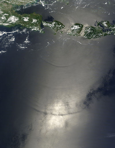
Le détroit de Lombok et ses courants :
Traversé une partie dans une coquille de noix large de 80cm, avec vagues de trois mètres autour et la peur dans les yeux du type à la barre. Jamais été aussi heureux d’arriver sur le rivage.
Série satellite complète :
►http://www.guardian.co.uk/environment/gallery/2010/dec/06/satellite-eye-on-earth
#geo #satellite

KingOfSat - Annuaire & Zapping Satellite Européen
►http://fr.kingofsat.net

geotagged - Nicolas Hoizey’s Tagged Photos - Google Maps
►http://www.google.com/maps?f=q&hl=en&q=http://api.flickr.com/services/feeds/photos_public.gne%3Fid%3D38608514%40N00%26format%3Drss_200%26georss%3D1%26ta
Mes dernières photos sur Google Maps en 10 secondes grâces aux flux GeoRSS de Flickr !
#géo #Flickr #google #maps #carte #satellite #position #géolocalisation #geo #rss #georss #flux #photo #photos