


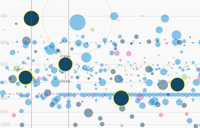
Interactive graphic: Every active satellite orbiting earth - Quartz
▻http://qz.com/296941/interactive-graphic-every-active-satellite-orbiting-earth
Interactive graphic: Every active satellite orbiting earth - Quartz
▻http://qz.com/296941/interactive-graphic-every-active-satellite-orbiting-earth

pour une base encore plus complète, avec absolument tous les satellites, ▻http://cas.uqam.ca (base spacedata, cf description page 57 ▻http://cas.uqam.ca/pub/R/web/CASdatasets-manual.pdf)

New study questions the accuracy of satellite atmospheric temperature estimates
▻http://www.theguardian.com/environment/climate-consensus-97-per-cent/2014/nov/07/new-study-disputes-satellite-temperature-estimates
In fact, for the time period 1987–2006, the [increase in] temperatures among the four groups that collect satellite data ranges from 0.086°C per decade to 0.22°C per decade. In more recent years, the trend is much reduced, and for two of the leading satellite groups (University of Alabama at Huntsville and Remote Sensing Systems), temperatures are basically flat.
The recent flatness in satellite temperatures as surface temperatures continue to rise has presented a quandary for scientists. Are both results real? Is there some reason they diverge? Is one measurement more accurate than the other? This is one of the areas of very active research.
A contribution to this question appeared last week by researcher Fuzhong Weng and his colleagues. The paper, published in Climate Dynamics, claimed to find the reason for much of that difference – the authors report that the satellite trends could be off (too cold) by perhaps 30%. If true, this work would go a long way toward reconciling the differences between surface and satellite measurements.
[...] Of course, whenever a study that is this significant is published, there is deserved skepticism. We have to be guarded in our acceptance until further work is done and until other teams have had a chance to review the findings.
UNOSAT joins the fight against Ebola | CERN
▻http://home.web.cern.ch/about/updates/2014/11/unosat-joins-fight-against-ebola
“The Ebola outbreak merited the activation of the Disaster Charter - a first for such a health emergency - and now #satellites from every continent are supporting the fight against #Ebola.”

Conférence Découvertes | Quand les satellites auscultent la couleur de l’eau des océans / IRD - Nouvelle-Calédonie
▻http://nouvelle-caledonie.ird.fr/layout/set/print/toute-l-actualite/evenements/conference-decouvertes-quand-les-satellites-auscultent-la-cou
Les constellations de #satellites surveillent quotidiennement les #océans entre les îles de l’archipel mélanésien jusqu’aux les baies du lagon de la Nouvelle-Calédonie. Grâce à des capteurs dédiés à l’étude de la « #couleur_de_la_mer », le suivi du #phytoplancton et de la #turbidité _des_eaux sont réalisés en analysant ces mesures.
#environnement #prévention #images_satellites #imagerie_satellite #IRD Institut de recherche pour le développement #Nouvelle-Calédonie

Satellite zooms in on crucial carbon questions | Climate News Network
▻http://www.climatenewsnetwork.net/2014/06/satellite-zooms-in-on-crucial-carbon-questions
The ability of scientists to make accurate predictions about future effects of CO2 will be boosted by vital data from a US satellite being launched to take a detailed inventory of the planet’s sinks and sources of carbon.
LONDON, 28 June, 2014 − The US space agency NASA is about to send up a satellite that will provide vital data for predicting future effects of CO2 by taking the measure of the planetary carbon budget.
#satellites #climat #co2 #espace
Petit stress pour la lancer (le 1er juillet) toutefois, vu que le lancer du premier OCO avait échoué en février 2009. Après l’échec du premier, ils ont reconstruit l’instrument à l’identique faute de moyens, donc c’est la même technologie qu’il y a 5 ans, ce qui est un peu dommage. L’équipe OCO a eu le temps de se préparer et s’était reportée sur l’analyse des données du satellite japonais GOSAT qui a des caractéristiques similaires. Du coup ils devraient être prêts à fournir des estimations de CO2, de ses sources et puits sassez rapidement. J’imagine leur impatience et leur nervosité en ce moment.
Le gouvernement US autorise l’utilisation par l’industrie d’images #satellites à une résolution supérieure à 50 cm...
U.S. Government Eases Restrictions on DigitalGlobe
▻http://www.spacenews.com/article/civil-space/40874us-government-eases-restrictions-on-digitalglobe
Previously, Longmont, Colorado-based #DigitalGlobe was not permitted to sell its sharpest satellite images to non-U.S. customers. Some of the company’s existing satellites can collect images at resolutions sharper than 50 centimeters, but prior to the ruling, it could only sell that information to the U.S. government.
[...]
DigitalGlobe’s planned WorldView-3 satellite, which will feature a ground sampling distance of 31 centimeters, is slated for launch Aug. 13 or 14 from Vandenberg Air Force Base, California, the company said. For that satellite, “updated approvals” will permit DigitalGlobe to sell black-and-white images with 25-centimeter resolution, along with color images at 1-meter resolution, to all customers six months after it is declared operational.
... Ceci, le lendemain de l’annonce de l’achat de Skybox par Google. Mais les relations avec DigitalGlobe semblent bonnes.
Google recently signed a 10-year imagery supply contract with DigitalGlobe valued at an estimated $10 million to $20 million per year, Quilty noted. While Skybox’s planned constellation of 24 satellites will offer high revisit rates – Skybox currently has one satellite on orbit – DigitalGlobe has advantages in terms [of] better imagery resolution, accuracy and diversity of spectral bands, he said.
Moreover, Quilty said, a Google-owned Skybox is not likely to threaten DigitalGlobe’s core U.S. government business.
Ruling on sharper satellite images poses a privacy problem we can no longer ignore
▻http://theconversation.com/ruling-on-sharper-satellite-images-poses-a-privacy-problem-we-can-n
Digital Globe says that new satellites will be able to show “manholes and mailboxes". They are also getting closer to seeing us.
If satellite imagery continues to improve, enabling the identification of individuals, then the issue of privacy will grow in significance.

Outernet ou l’accès universel et gratuit à #Internet depuis l’espace
▻http://www.silicon.fr/outernet-acces-internet-gratuit-universel-espace-92790.html
Si l’Outernet arrive à déployer ses ailes ou plutôt à se mettre en orbite, il pourrait révolutionner l’accès à #Internet et le rendre universellement gratuit. Via un réseau de centaines de satellites low cost. […]
Je sais pas pourquoi, mais ça semble à la fois évident et pas crédible… Mais l’idée est récurrente, à commencer chez Amazon : ▻http://www.extremetech.com/electronics/164811-amazon-testing-licensed-#wifi-could-lead-to-cheap-unified-global
On en apprend plus sur ▻http://www.contrepoints.org/2014/02/25/157723-outernet-linternet-gratuit-universel-et-non-censure
La constellation de #satellites sera placée à une orbite basse et connectée à un réseau de stations au sol.
Station = terminal ou relais ? Car s’il faut des relais au sol, ça me semble moins intéressant pour « lutter contre la censure ».
Au début, les premiers satellites ne pourront diffuser qu’une communication unidirectionnelle, avant de passer à une communication bidirectionnelle lorsqu’ils seront suffisamment nombreux.
Forcément, si c’est du wifi et sans relais au sol, ça ne peut être qu’unidirectionnel... Et donc je vois pas comment on lutte plus efficacement et significativement contre la censure quand les requêtes des utilisateurs passent encore par le réseau « national ».
Cependant, l’ensemble des sites Web ne seront pas accessibles, la priorité étant donnée aux sites proposant des actualités internationales indépendantes, à l’encyclopédie #Wikipédia ou aux services d’éducation en ligne par exemple. Il est prévu que les utilisateurs puissent choisir eux-mêmes la liste des sites/services prioritaires par #SMS ou par application #smartphone.
Mouais. Bon. Bref, pour tout savoir, c’est par ici : ►https://www.outernet.is


@Homlett L’article de silicon.fr dit complètement n’importe quoi. Il vaut mieux regarder le site Web originel ▻http://outernet.is et pas cette soupe journalistique écrite par un stagiaire pressé et incompétent. Oui, Outernet est unidirectionnel. Ce n’est pas un accès à l’Internet, juste de la diffusion de contenus. Utile mais pas révolutionnaire.

@stephane Oui, en effet. Je suis arrivé sur silicon.fr via un respecté twittos IT... Je ferai mieux de partager les sources originales à l’avenir, mais c’est surprenant ces articles aussi approximatifs dans une presse soit disant plus ou moins spécialisée. Et quand je pense qu’il doit en être autant sur des sujets dont je n’ai pas les clefs pour voir ou soupçonner les approximations (ou les erreurs) c’est carrément inquiétant...
Skybox Imaging Captures World’s First High-Resolution, HD Video of Earth from Space (1080p HD)
►http://www.youtube.com/watch?v=fCrB1t8MncY
Skybox Imaging Captures World’s First High-Resolution, HD Video
premières #vidéos #satellites commerciales (civiles) en haute-déf
#images #espace

Un jet d’eau sur Europe
▻http://www.sciencesetavenir.fr/espace/20131213.OBS9488/un-jet-d-eau-sur-europe.html
De nouvelles images du satellite de Jupiter laissent entrevoir un jet de vapeur d’eau qui jaillit au pôle sud d’Europe.
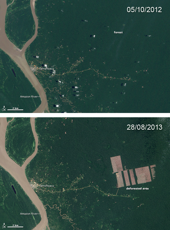
Stop the palm oil industry’s assault on the Amazon
▻https://www.rainforest-rescue.org/mailalert/933/stop-the-palm-oil-industry-s-assault-on-the-amazon#more
In 2000, the Peruvian government declared oil palm plantations in the Amazon region to be in the national interest. Melka’s plantation companies are said to have already purchased 60,000 hectares of primary rainforest from the government in the Loreto region alone and requested a concession to clear more than 100,000 hectares of virgin forest in Loreto and in the neighboring region of Ucayali.
The responsible politicians and officials now claim to have been unaware of the deforestation by Melka’s plantation companies. Since Peru prohibits the clear-cutting of primary forest for oil palm plantations, the companies first clear the land without a permit and then offer to reforest it with oil palms.
In recent months (...) life in Peru’s Amazonian lowlands has been marked by fear and turmoil. Foreign speculators have begun with large-scale clear-cutting – initially in secret. Promises, threats and blackmail have prompted farmers to sell their rainforest plots to the plantation companies at well below their value.
#huile_de_palme #Amazonie #Perou #deforestation #surveillance #satellites
The Big Atlas of LA Pools
▻http://benedikt-gross.de/log/2013/06/the-big-atlas-of-la-pools
The “Big Atlas of LA Pools” is about the process of mapping and map-making in the contemporary age of #big_data, #open_data, #crowdsourcing, and citizen science.
Mappers spot all the pools in L.A. Basin
▻http://www.latimes.com/local/la-me-c1-swimming-pools-20131202-dto,0,198951.htmlstory
The two men started by sending two sets of satellite photos from the federal National Agriculture Imagery Program — one a true color composite, the other a false-color version to make the pools easier to spot — to a crowd-sourcing service in India. They paid workers $300 to draw the outline of every pool shown in the pictures onto a computer program.
They then spent an additional $350 to have the initial count double-checked by Amazon Mechanical Turk, another crowdsourcing service. Workers there inspected images of each swimming pool’s location to confirm it was a body of water and not, say, a house with a blue roof.
The duo used eight publicly available databases, including latimes.com’s Mapping L.A., for the project. Other data sets used included the county’s parcel boundaries service, the Los Angeles County sheriff’s crime database, the assessor’s data set and a database that contained those donating money during the Proposition 8 campaign on gay marriage and the Megan’s Law list of registered child molesters.
[...] Lee agrees: “The feeling that this is occurring with armies of people and computers doing the exact same exploration at a higher scale is frightening.”
North Korean gulags ’expanding’, satellite images show - Telegraph
▻http://www.telegraph.co.uk/news/worldnews/asia/northkorea/10496464/North-Korean-gulags-expanding-satellite-images-show.html
North Korean gulags ’expanding’, satellite images show
Amnesty International report says beatings and executions common, with testimony from former guards who watched inmates dig their own graves
#corée_du_nord #images_satellites #surveillance #contrôle #satellites

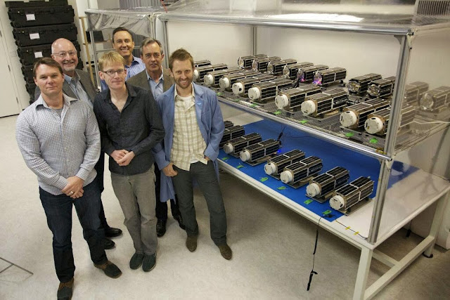
What a difference a decade makes in satellite imaging | GeoSprocket Community Jive
▻http://geosprocket.blogspot.fr/2013/11/what-difference-decade-makes-in.html
This is a commercial, high-resolution earth imaging #satellite before launch in 2001:
And this is a roomful of them in 2013:

While the dishonest and the stupid are attempting to railroad everyone into military endeavours devoid of public benefit, let us remember that France stood out of the Iraq war because it had independent orbital imaging capabilities showing that the WMD claims were nonsense... Meanwhile, the USA took for a ride all the blind ones who had decided that US imagery was cheaper and good enough.
Military sovereignty is also about being able to remain peaceful - let us remember that next time the time for budget cuts come: ▻http://fistfulofeuros.net/afoe/spies-for-europe
–----------------------------------------------------------
The original statement is in this Ken Silverstein piece (▻http://harpers.org/sb-creating-th-1149534425.html):
“They say everyone else was wrong,” said this former official, “but we conditioned them to be wrong. We spend [tens of billions of dollars per year] on signals intelligence and when we reach a conclusion, the people who spend less than that tend to believe us. They weren’t wrong, they chose to believe us. The British, Germans, and Italians don’t have all those overhead assets, so they rely on us. Historically they have been well-served, so they believe us when we tell them the earth is round. The French have their own assets—and guess what? They didn’t go with us”
Guilhem Penent, of France’s IFRI and IRSEM thinktanks, writes in the Space Review (▻http://www.thespacereview.com/article/2340/1) as follows:
“Regarding outer space, France’s main objective is to perpetuate its autonomy and national sovereignty. As sovereignty is the state of determining itself based on its own will without depending on other nations, satellites are, first and foremost, the guarantee of France’s autonomy in assessment and thereby in decision-making”
The decision not to follow the US in 2003 was thus taken by then President Jacques Chirac in accordance with intelligence based for the most part on Earth-imaging satellite HELIOS 1, whose findings were in contradiction which was being said at the UN Security Council. When the war in South Ossetia broke out in 2008 between Russia and Georgia, then President Nicolas Sarkozy, as chair of the Presidency of the Council of the European Union (EU), used images provided by HELIOS 1 and HELIOS 2 to deny Russia’s allegations about the withdrawal of its troops when those troops were actually progressing southward.
This is the first public confirmation, I believe, that the French did in fact stand out of the Iraq war because HELIOS imagery showed that the WMD claims were nonsense

#DigitalGlobe creating real-time heat map of conflict in Africa
via @antiatlasofborders
DigitalGlobe is using satellite imagery and data analytics to create a real-time map of what’s going on in the world.
▻http://venturebeat.files.wordpress.com/2013/08/screen-shot-2013-08-28-at-3-00-35-pm.png?w=558&h=9999&c
▻http://venturebeat.com/2013/08/28/digital-globe-creating-real-time-heat-map-of-conflict-in-africa
#carte #cartographie #visualisation #conflit #guerre #Afrique
Many of DigitalGlobe’s analysts have background in defense and intelligence. They are using the satellite imagery to predict extremist activity all across Africa, seek out connections among those extremist groups, and identify high risk areas to mitigate threats. NGOs are also using this information to track humanitarian crises, and in one case, to document the latest tactics around elephant poaching to fund an army in the Congo.
On avait déjà référencé ce site que quelqu’un du centre international pour la paix à Vienne m’a fait découvrir, mais je ne le retrouve pas. C’est donc bien de le reposter et de bien le taguer :)
En tout cas utile comme source pour une carte des conflits dans le monde (une des cartes les plus difficiles à penser et à composer).
Ah voilà à quoi ça me faisait penser. Ce n’est pas tout à fait pareil

Incendie sur une plateforme de gaz en Caspienne
ITAR-TASS : Gas well on fire at Bulla-Deniz offshore Caspian field
▻http://www.itar-tass.com/en/c32/844240.html
▻http://www.itar-tass.com/data/Newses/MainPhoto/844240.JPEG
There has been a fire outbreak in a well at the Bulla-Deniz gas condensate field on the Caspian Sea shelf. According to a report posted on the website of the State Oil Company of Azerbaijan (SOCAR), which is the operator of the field, the fire has engulfed exploration well No 90 in the northeast wing of Bulla-Deniz.
According to SOCAR, the fire broke out on Saturday night during drilling at a depth of more than 5.8 thousand meters. “At 23:30 local time (22:30 MSK) a wild gas blowout occurred after which the fire started,” the statement says. It says that all the workers who were on the platform were evacuated to the shore.
“At present, fire-fighting vessels that have surrounded the platform control the situation. The fire extinguishing operation will begin after the plan for shutting down the well is prepared,” SOCAR stated.
The causes of the fire outbreak are being investigated.
The Bulla-Deniz field is located in the open sea at a distance of 80 kilometres from Baku. It was discovered in the mid-1970s. The sea depth at the field is about 26 metres.
Du côté de la société nationale, un peu de langue de bois…
SOCAR prepares schedule to rectify accident at Bulla-Deniz offshore gas field - Trend.Az
▻http://en.trend.az/capital/energy/2180565.html
The State Oil Company of Azerbaijan (SOCAR) is conducting work on developing a programme to rectify the consequences of the accident that took place at the Bulla-Deniz offshore gas field, SOCAR head Rovnag Abdullayev told journalists on Monday.
… prépare un plan d’action pour corriger l’accident…
Dit autrement, …
APA - SOCAR vice-president : Overcoming of accident in Bulla-deniz gas field is realized at the cost of internal forces’ - INTERVIEW
▻http://en.apa.az/news/197969
As SOCAR President Rovnag Abdullayev told journalists yesterday, fire-extinguishing is not a big problem.
En fait, le problème c’est que la SOCAR aimerait bien ne pas trop démolir le puits existant ( segregation )…
Preparation works on segregation have already been started in the well. The initial actions comprise to approach the well and clean the broken equipment. Thereafter, we will begin to work for extinguishing and segregation of it. I want to note that the Commission continues its work on a daily basis. Specific measures will be defined for each day depending on the situation.
On réfléchit, on se prépare et on va bientôt s’attaquer au problème.
Pas besoin des experts étrangers.
Q. Media reports that BP-Azerbaijan is closely participating in the fire-extinguishing. What can you say about their role in this situation?
- BP-Azerbaijan company is one our main foreign partners functioning in Azerbaijan and has been cooperating with the State Oil Company for years. In case of this accident, they addressed us that they are ready to participate in the elimination process of the accident. Taking into account the experience of BP gained in the Gulf of Mexico, we accepted their proposal. We also invited their specialist to the meeting yesterday. Opinions of BP’s experts were also taken into account. It became clear that there is nothing in their approach to the situation. Other Azerbaijan-based foreign oil companies have offered their help in fire-extinguishing. SOCAR appreciates urgent reactions of BP and other foreign partners and their efforts to help us in the situation and thanks their leaderships. Consequently, the proposals of Azerbaijani experts reflect the real situation more clearly. We prefer to solve the issue at the cost of internal forces. I’m sure that Azerbaijani experts will decently overcome this problem.
« L’analyse de BP, forte de son expérience sur Deepwater Horizon, ne nous apprend rien, on avait déjà tout bon. »
Bulla-Deniz, incident toujours en cours. Article du 22/08, le seul sur gg:news ; source arménienne…
Пожар на месторождении « Булла-дениз » все еще не потушен
▻http://www.yerkramas.org/2013/08/22/pozhar-na-mestorozhdenii-bulla-deniz-vse-eshhe-ne-potushen
Официальная информация по данному поводу очень скупая.
Soit pour gg:translate
Les informations officielles sur cette question est très avare.
En tous cas, il y a nettement plus de monde autour de la plate-forme que sur les photos précédentes …
EDIT : oups, cette photo est en réalité une photo de Deepwater Horizon…
Intéressante photo issue de Landsat 8 montrant la localisation de Bulla-Deniz 90.
Issue de SkyTruth : The Blowout du Jour — Flaming Rig in the Caspian Sea
▻http://blog.skytruth.org/2013/08/socar-90.html
qui annonce un suivi en fonction des passages des satellites.
Vidéo de la plateforme en feu. On notera l’efficacité, on va dire, relative de l’arrosage…
▻http://www.youtube.com/watch?v=ohYUYj5Xs_s
Le point de la situation (23/08) : ça continue, mais comme c’est du gaz, il n’y a pas d’impact sur l’environnement.
Ecology Ministry : Fire on Bulla-Deniz Has No Effect on Environment of Caspian Sea
▻http://contact.az/docs/2013/Social/082300046935en.htm
The fire on the Bulla-Deniz gas field that broke out at the beginning of the night of Aug. 18 is still going on. According to the spokesman for SOCAR Nizamaddin Guliyev, the order of the President of SOCAR established a commission to deal with the accident. Estimates of the economic and environmental consequences of the accident will be made later.
Meanwhile, representatives of the Ministry of Environment are monitoring at the scene to assess the impact of the fire on the environment. Experts estimate the impact as “insignificant.”
The representative of the Environment Ministry Mirsalam Ganbarov told Turan that for security purposes, to approach the scene of the fire is impossible, and the surveillance and monitoring are conducted in the distant way. Given that methane gas burns, any damage to the environment has not been registered, he said.
======================
Note : un syndicaliste du secteur prétend qu’il y a des victimes mais qu’elles sont camouflées dans une clinique privée (info du 19/08)
Fire on Bulla-Deniz Continues (UPDATED)
▻http://www.contact.az/docs/2013/Economics&Finance/081800046313en.htm
However, the head of the Committee for Protection of Oil Workers Rights Mirvari Gahramanli argues that there are victims, but their presence is hidden, and for this purpose they are placed in a private clinic. Gahramanli believes that the fire was caused by leadership of the Office of Complex Drilling Works.

Màj de l’incendie en Caspienne : toujours l’espoir de sauver l’installation, toujours en feu...
www.contact.az/docs/2013/Economics&Finance/082600047215en.htm

Merci, @nicolas2. L’article est de nouveau illustré avec une photo de Deepwater Horizon…
Fire on the caspian gas well still continues
▻http://www.contact.az/docs/2013/Economics&Finance/082600047215en.htm
The upper structures of the well were removed so that fire will come out of the well vertically without expanding throughout the foundation.
The attempts have been made to extinguish the fire, but pressure is still high on the well and the traditional methods bring no results. The oilmen’s goal is to save the exploration well, where the drilling progress reached 5868 meters.
Aucune nouvelle de la plateforme, mais des sources bien informées semblent indiquer qu’on essaye toujours de l’éteindre… (26/08/13 13:57 locales)
(photo de Deepwater Horizon)
Quenching of offshore gas well in Caspian Sea continues - ABC.AZ
▻http://abc.az/eng/news/main/75678.html
The State Oil Company of Azerbaijan (SOCAR) has not reported yet on progress with the extinguishing of exploration well #90 at offshore field Bulla-Deniz, a fire at which started at night on 18 August.
Informed sources say that despite the absence of official reports, the fire-fighting work continues.
Un communiqué de la SOCAR ! (26/08/13 17:46 locales)
la flamme qui s’étendait partout dans un rayon de 350 mètres est désormais dirigée vers le haut à la suite d’utilisation de « moyens militaires »…
APA - SOCAR specifies plan of works to be carried out for fire-extinguishing in Bulla-deniz field
▻http://en.apa.az/xeber__socar_specifies_plan_of_works_to_be_car_198286.html
SOCAR has made a statement in connection with the fire in Bulla-deniz field.
According to information, during the accident mouth of the well #90 was closed against equipments and as a result, the flame spread around creating high temperature within a radius of 350 meters. It made impossible to approach the well.
The information says that first of all the commission consisting of highly skilled employees SOCAR and the Emergency Situations Ministry was to direct the movement of flame vertically. Military technique was used for this purpose. Consequently, the flame was compacted and vertically directed.
At present, works are being continued in direction of elimination of the accident.
À la suite de l’intervention précédente : on aurait pu l’éteindre, mais on ne préfère pas…
SOCAR localizes fire in Bulla–Deniz field - AzerNews
▻http://www.azernews.az/oil_and_gas/58599.html
The fire could be extinguished. However, it was decided to prevent the breakdown by continuous burning of gas to prevent the sea pollution and maintenance of safety of workers who are on the platform.
In this purpose, full fire extinguishing was considered as inappropriate, SOCAR said.
À noter dans ce dernier article, il y a une nouvelle photo, avec un brûleur bien dirigé dans le sens opposé à la plateforme et isolé par un rideau d’eau. Ce qui semble correspondre à la situation décrite.
Il n’en est rien, heureusement, car on voit très distinctement des irisations sur la mer… Il s’agit, en fait, d’un recadrage de la plateforme Q4000 utilisée dans le Golfe du Mexique dans le cadre de la dépollution de l’accident de Deepwater Horizon.
La photo complète, extraite de ▻http://seaturtles.org/article.php?id=1725
▻http://seaturtles.org/img/original/xRigPlatfrm_7182.jpg
Cf. ▻http://en.wikipedia.org/wiki/Q4000
Aux dernières nouvelles, elle est toujours dans le Golfe du Mexique, en route vers le sud à 0,1 nœuds…
▻http://www.marinetraffic.com/ais/fr/shipdetails.aspx?MMSI=369550000
Un rideau d’eau a été créé sur la plateforme. 11 navires présents sur le site, dont le bateau grue Shirvan.
28/08/13 14h30 locales (3h de plus qu’en France)
Water screen has been created over the SOCAR damaged offshore gas well - ABC.AZ
▻http://abc.az/eng/news/main/75729.html
The State Oil Company of Azerbaijan Republic (SOCAR) reported about successful process of repairing damages after the accident followed by the fire during the implementation of the drilling program at the exploration well №90 on offshore field Bulla-Deniz.
SOCAR informs that 11 ships including “Shirvan” crane ship are engaged in the works. The works are conducted by 6 emergency response groups.
“Today at 8.00am 4 firefighting ships created the water screen over the damaged well head to provide safe working conditions at the drilling platform”, - SOCAR said.
NB : à 4h du matin (locales) le navire quittait Bakou en route vers le sud (vers la plateforme)
▻http://www.marinetraffic.com/ais/fr/shipdetails.aspx?mmsi=423134100
Les communiqués de la SOCAR sont toujours aussi incompréhensibles. Celui-ci date d’il y a 2 jours (27/08/13 15h locales, je ne l’avais pas vu)
Il n’y a plus de feu sur la plateforme, mais toujours à la tête du puits (?)
The fire at the exploration well of the SOCAR offshore field cannot stop SOCAR’s from taking seismic survey at the site - ABC.AZ
▻http://abc.az/eng/news/main/75704.html
The fire at the exploration well №90 has been extinguished by the gun-fire of the Azerbaijan State Border Service military ships. The SOCAR specialists are preparing to suppress the fire at the well head – yesterday the firefighting and mine-rescue teams managed to approach the damaged platform at 2-3 meters.
Sinon, les illustrations continuent à faire le tour du monde des plateformes…
APA - SOCAR makes next statement regarding the accident in Bulla-deniz field (29/08/13 14h locales), 20% du matériel débarqué
▻http://en.apa.az/news/198478
The works are being continued in direction of elimination of the accident. As a result of taken measures, 20% of drilling equipment in the well has been dismantled and led to shore.
Update (30/08/13 14h locales) 40% du matériel débarqué
APA - 40% of drilling equipment in Bulla-deniz field dismantled
▻http://en.apa.az/news/198560
The works are being continued in direction of elimination of the accident in the well #90 in Bulla-deniz field. About 35-40% of drilling equipment has already been dismantled and led to shore.
All the measures are being carried out in accordance with the considered plan.
31/08/13 14h locales (on a maintenant un point tous les jours)
45% de l’équipement à terre.
SOCAR transports to land about 45 per cent of drilling equipment from emergency platform at Bulla-Deniz - Trend.Az
▻http://en.trend.az/regions/scaucasus/azerbaijan/2184645.html
SOCAR (the State Oil Company of Azerbaijan) has dismantled and transported to land about 45 per cent of drilling equipment located on the emergency well in the Bulla-Deniz field in the Azerbaijani sector of the Caspian Sea, a SOCAR statement published on Saturday, said.
… et une nouvelle photo
The Ecological Research Expedition of the Ecological Monitoring Department held the ecological monitoring in Bulla Daniz field of N.Narimonov OGED between 04.09.2012 and 07.09.2012 by vessel MPK-452. The samples of sea water, zooplankton, and phytoplankton and bottom sediment were taken from the 17 stations of the above-mentioned field in order to determine the parameters effecting to Caspian Sea. Physical and chemical characteristics of water environment were studies, speed and direction of water flow was measured, meteorological research of the site was made.
J’ai laissé passé la journée d’hier (1/09/13) : on en était à 50% débarqué « au rythme prévu »
SOCAR Transports To Land About 50 Per Cent Of Drilling Equipment From Emergency Platform At Bulla-Deniz
▻http://en.haberler.com/socar-transports-to-land-about-50-per-cent-of-297497
SOCAR (the State Oil Company of Azerbaijan) has dismantled and transported to land about 50 per cent of drilling equipment located on the emergency well in the Bulla-Deniz field in the Azerbaijani sector of the Caspian Sea, said in a SOCAR statement published on Sunday.
’Measures to prevent the accident taken by specialists of SOCAR and the Ministry of Emergency Situations are carried out in accordance with the prescribed schedule’, the statement said.
======================
Dans le communiqué d’aujourd’hui, 2/09/13, un peu de nouveau : intervention d’une compagnie états-unienne spécialisée et décision de fermeture du puits.
Et donc, abandon du forage de quasi 6000 mètres ?
SOCAR to close emergency well at Bulla Deniz platform - Trend.Az
▻http://en.trend.az/regions/scaucasus/azerbaijan/2185031.html
SOCAR (the State Oil Company of Azerbaijan) has completed cleaning the drilling platform equipment at the Bulla-Deniz field where an accident occurred earlier, a SOCAR statement, published on Monday, reported.
Work was conducted using the crane ships Shirvan and Z. Tagiyev.
Measures to prevent the accident taken by SOCAR specialists and the Ministry of Emergency Situations are also involved the representatives of the American company Boots & Coots international company Well Control.
A decision was taken that the closure of the well will be carried out using the Qurban Abbasov crane vessel. Currently work is underway on the preparation of the ship.
====================
Enfin, une vidéo du 21/08/13 montrant l’incendie vu de la terre (sans doute, environ 25 km)
▻http://www.youtube.com/watch?v=oYZxK-7KZek
Travaux suspendus aujourd’hui pour cause de forts vents du nord. (2/09/13 14h locales). SOCAR confirme recourir aux services de Boots & Coots (filiale spécialisée de Halliburton)
SOCAR has invited specialists from Boots & Coots to extinguish fire at the gas well in the Caspian Sea - ABC.AZ
▻http://abc.az/eng/news/main/75805.html
The platform has been cleared from the structures fallen during the fire. The Company also requested assistance in fire extinguishing and well conservation from American Company Boots & Coots International Well Control”, - SOCAR reports. The crane ship “Qurban Abbasov” was also sent to the accident site.
“The works will be continued as soon as the weather conditions get better”, - SOCAR said. Squall northern winds are raging over the Caspian Sea in Absheron peninsula offshore area from the night of September 1.
#Bulla_Deniz l’info du jour : quelques chiffres.
3Mm^3 de gaz brûlés par jour.
Soit un peu moins de la moitié de ce que brûlait l’ensemble des torchères du gisement ACG à la grande époque.
Pour info, les 3 millions de mètres cubes de gaz quotidiens équivalent à 2700 tonnes d’équivalent pétrole.
SOCAR continues works to save well at Bulla-Deniz field - Trend.Az
▻http://en.trend.az/capital/energy/2185649.html
According to Abdullayev at the moment some 2.5-3 million cubic meters of gas per day are being burned because of the fire.
Alongside with this SOCAR head noted that, earlier nearly 6.7 million cubic meters of gas per day were burned in the flare of the Azeri-Chirag-Guneshli block of fields without any significant harm to the environment (currently, this indicator is brought to minimum thanks to the engineering measures).
La photo du jour est une plateforme du gisement Azeri-Chirag-Guneshli. Sans doute la plateforme occidentale.
On bosse fort (conformément au plan et avec un nouveau bâtiment de soutien) et c’est pour bientôt.
Bientôt 4 semaines. Le rythme de l’info se ralentit très nettement…
SOCAR attracts ship with special equipment to extinguish emergency well - Trend.Az
▻http://en.trend.az/capital/energy/2188808.html
Gurban Abbasov vessel will also be involved in extinguishing the fire. Now the ship is being prepared. Currently, serious work is carried out, and most likely in the near future the fire will be eliminated," Yusufzadeh said.
According to him, work is going according to plan.
Le Gurban Abasov (après refonte complète en 2011)
Aujourd’hui, on fait le ménage sur la plateforme…
SOCAR starts cleaning emergency well platform at Bulla-Deniz field - AzerNews
▻http://www.azernews.az/azerbaijan/59400.html
Azerbaijan’s state energy company SOCAR starts cleaning the territory of the platform around the broken down well at the Bulla-Deniz field in the Azerbaijani sector of the Caspian Sea, SOCAR said on September 12.
The company reported that the cooling of the platform is carried out uninterruptedly where the broken down well is located. The work is implemented with the help of “Whirlwind” and “Caspian Support” vessels.
BP : on peut aider ?
PDG de la SOCAR : « Non, non, ici c’est le pays des flammes » (surnom traditionnel de l’Azerbaïdjan).
Excellent !
Ça correspond à la situation initiale puisque, depuis au moins une semaine, SOCAR a recours aux services de Boots&Coots (fondée par 2 anciens de chez Red Adair, puis rachetée par Red Adair avant de l’être par Halliburton).
Bulla Deniz : rien de neuf (et la photo ne change plus depuis bientôt 3 semaines)
SOCAR : Work on elimination of accident at Bulla-Deniz directed to its rescue - Trend.Az
▻http://en.trend.az/capital/energy/2190881.html
All efforts on elimination of the accident at the Bulla-Deniz well are being directed towards its saving, SOCAR head Rovnag Abdullayev told journalists on Monday.
According to him, in order to save the well, the State Oil Company turned to Halliburton which has extensive experience with flowing wells and now experts from this company are working within the prepared programme.
“Currently work is being carried out for clearing the area around the well, so that they can install the equipment necessary for commissioning it,” Abdullayev stressed.
Regarding the assessment of the damage caused by the accident, Abdullayev said that estimates will be conducted after the completion of the work on elimination of the accident.
According to him, the extinction of the well is not a problem. C’est après que ça se complique…
State Energy Company to replace equipment at Bulla-Deniz emergency well - AzerNews (20/09/13)
▻http://www.azernews.az/oil_and_gas/59779.html
Azerbaijan’s state energy company SOCAR is preparing to replace equipment burned out at the gas exploration well at the Caspian field of Bulla Daniz that has been blazing since August 17, SOCAR vice-president of oil-gas production and transportation Rahman Gurbanov told Baku-based Trend news agency on September 20.
Gurbanov heads the special commission for eliminating the outcome of the Bulla-Deniz accident.
According to him, the extinction of the well is not a problem . The main task in the process of elimination of the accident’s outcome is the completion of preparations and subsequently the closing of the well.
“Currently preparations are underway to replace the entire equipment which was burned down. After completion of this process, the well will be closed and discarded,” Gurbanov said.
Reprise du feuilleton après 8 jours de silence radio.
Apparemment, les équipes vont commencer à poser de quoi contrôler la tête du puits.
Un cadeau pour le futur nouveau mandat du président ?
SOCAR to install new equipment at Bulla Deniz emergency well - AzerNews
▻http://www.azernews.az/oil_and_gas/60196.html
Azerbaijan’s state energy company SOCAR has launched the installation of the control head in the emergency gas exploration well at the Caspian field of Bulla Deniz that has been blazing since August 17, SOCAR head Rovnag Abdullayev told journalists on October 1.
According to him, all necessary equipment was delivered and tested and deployed before. However, work was not carried out last week due to bad weather. Currently, the weather is conducive for installing the equipment.
Du 4 octobre…
SOCAR speeds up closure of gas blowout of emergency well in Caspian Sea - Trend.Az
▻http://en.trend.az/capital/energy/2197914.html
SOCAR is preparing to cut off the unusable flange connection at the emergency wellhead at Bulla-Deniz field in the Azerbaijani sector of the Caspian Sea, according to a statement released by the State Oil Company on Friday.
According to the statement, for now in the framework of preparation to cut the flange connection, cutting system delivered from USA, is being installed in the construction site of SOCAR.
After completion of the cutting process, the works will start to assembly the wellhead and to direct gas to the gas transportation system
Ça bouge ?
SOCAR expects favourable forecasts for elimination of accident at Caspian Sea well - Trend.Az (7/10/13)
▻http://en.trend.az/capital/energy/2198408.html
Mais le reste est derrière #paywall et le début de la brève sur gg:news reprend l’historique de l’accident…
Bulla Deniz 90, après 15 jours de silence complet, une brève sur la plate-forme en feu, abondamment reprise (localement), même si elle ne contient rigoureusement aucun élément nouveau.
Ah si, une nouvelle photo … de Deepwater Horizon !
Fire continues burning on Bulla Deniz field
▻http://www.contact.az/docs/2013/Economics&Finance/101800053982en.htm
Fire continues burning on the well No 90 on the Bulla Deniz field owned by State Oil Company of Azerbaijan (SOCAR) for three months.
On August 17, 2013 at 11.30 p.m. local time, 80 km south of Baku, there was an accident on the exploration well on the depth of 5868 meters under high gas pressure. The well flowing has caused fire, which continues till now. According to SOCAR’s estimates, the gas pressure was so high that every day over 5-6 million cub.m. of natural gas was burnt. Then the gas flow decreased to 2.5-3 million cub.m.
SOCAR said that it has no problems with fire extinguishing. The main goal is to save the exploration well, because there is a possibility to use the equipment left on the well after extinguishing and complete drilling. A lot of money and over a year was spent for drilling of a deep well.
Ça fait donc un tout petit peu plus de 2 mois que l’extinction de l’incendie ne pose aucun problème…
Bulla Deniz 90, on y est presque…
Apparemment, il reste à raccorder une dérivation.
SOCAR : Elimination of accident at Bulla Deniz field nearing completion - Trend.Az
▻http://en.trend.az/capital/energy/2203183.html
The process of elimination of the accident on a well at the Bulla Deniz offshore field is nearing completion, head of the State Oil Company of Azerbaijan Republic, Rovnag Abdullayev told journalists.
According to him, basically all works have already been conducted as part of the preparatory process for connection of the well.
In particular it is planned to install a preventer on the well, when weather conditions improve. This will allow connecting the well to the network.
“The process of elimination of the accident at the well is at final stage,” Abdullayev said.
Nota : encore une nouvelle photo, mais il est vrai que j’ai changé de journal. Ici, c’est l’appareillage de la plate-forme TPG500 de Shah Deniz en 2005 ou 2006 (c’est juste à côté).
=================
avec quelques détails en plus
APA - Rovnag Abdullayev speaks about work done at accident site of Bulla Deniz field
▻http://en.apa.az/xeber_rovnag_abdullayev_speaks_about_work_done_201458.html
“Prevention of accident at Bulla Deniz field is at the last stage. Together with State Oil Company of Azerbaijan, the US Company did the main work. Final work to bring 40-ton cranes is being done”, said the SOCAR President Rovnag Abdullayev.
According to him, the works on installation of pipe lines and tubes have already been completed.
“As a final stage, we’ll start putting of 40-ton cranes over the well. These works wil start tomorrow. This is a great and hard work”, he added.
Avec une signification du mot prévention un peu particulière.
Bulla Deniz, le puits est éteint, aujourd’hui 24 octobre.
Fin du feuilleton…
Fire at emergency well in Bulla Deniz field extinguished:source (UPDATE) - AzerNews
▻http://www.azernews.az/oil_and_gas/60937.html
Azerbaijan’s state energy company SOCAR has eliminated the fire in the gas exploration well at the Caspian field Bulla Deniz that has been blazing since August 17, a source in the oil and gas market told the Baku-based Trend news agency on October 24.
SOCAR said that due to the conscientious efforts of the company’s experts and the American company Boots & Coots, the process of installation of anti-gushing equipment at the well was completed and the well was fully taken under control, as a result of which the fire was extinguished.
According to the state oil company, currently work on li(n)king the well with the manifold is underway.

Merci infiniement @simplicissimus, pour cet haletant feuilleton à suspens... Je retenais mon souffle. J’ai aime, beaucoup.`
pour moi et pou quelqu’un que je ne dénoncerai pas c’est une forme de #nouveau_journalisme
Merci !
Ce qui m’a frappé quand j’étais sur place, c’est que rigoureusement personne n’était au courant. Quand on me demandait comment j’étais au courant, je répondais : « allez sur le front de mer le soir et regardez en direction de la salle de l’Eurovision ».
À chaque fois, on commençait à m’expliquer que c’était normal, que c’était une torchère… et quand je montrais la vidéo où, heureusement, on distingue parfaitement bien les couleurs azerbaïdjanaises sur la cheminée du bateau arroseur, on me redemandait comment je le savais.
Seule exception, ma voisine dans l’avion qui était au courant. C’était d’ailleurs la seule du groupe de 6 écossais venant régulièrement bosser pour BP.
Le message qui ne finit jamais...
▻http://www.today.az/news/business/127895.html
The accident at the Bulla Deniz offshore field in the Caspian Sea’s Azerbaijani sector did not significantly impact the environment, Head of the Ecology Department of the State Oil Company of Azerbaijan Republic (SOCAR), Azer Aliyev told journalists on Tuesday.
...

L’industrie spatiale en plein essor
(Checklist du Monde, 22 juin 2013)
Le secteur spatial est en plein boom. Le chiffre d’affaires a progressé de 7 % en 2012, à 189,5 milliards de dollars, nettement plus rapidement que la croissance mondiale, selon un rapport de la Satellite Industry Association (SIA). L’Europe tire bien son épingle du jeu dans ce #marché en expansion.
▻http://www.sia.org/wp-content/uploads/2013/06/2013_SSIR_Final.pdf

Et dans l’espace, au-dessus des #drones, il y a des #satellites
The Watchers via @opironet
▻http://www.wired.com/wiredscience/2013/06/startup-skybox
#Silicon_Valley #startup is launching a fleet of imaging satellites that are cheap, small, and ultra-efficient. Their up-to-the-minute snapshots of the planet will give us data that could upend industries, transform economies — even help predict the future.
Le Sud veut sa part des données satellitaires pour gérer ses ressources
▻http://www.lemonde.fr/planete/article/2013/04/12/le-sud-veut-sa-part-des-donnees-satellitaires-pour-gerer-ses-ressources_3158
les instruments embarqués à bord des satellites ont majoritairement le regard braqué vers les pays qui les ont financés. Et quand ce n’est pas le cas et que les données sont disponibles, parfois gratuitement, leur coût de traitement et d’interprétation peut s’avérer rédhibitoire.
« Le recours à ces technologies serait pourtant rentable dans le cadre d’une politique de développement », estime Didier Rigal, d’Astrium Géo-Information Services, une filiale du groupe EADS. « Les programmes d’observation de la terre tel SPOT [Satellite pour l’observation de la Terre] ont été lancés [en 1985] grâce des investissements publics, poursuit-il. Aujourd’hui, ces programmes ont été privatisés. L’équation économique qui permettrait la dispersion des données n’est plus la même. »

The Militarization of Space, So Far Pinfographics
▻http://www.pinfographics.org/ig/the-militarization-of-space-so-far
Overview of Cultural Heritage - Timbuktu, #Mali | UNITAR-#UNOSAT
▻http://www.unitar.org/unosat/node/44/1725
This map shows the location of cultural heritage sites in the city of Timbuktu. Some of these sites are reported to be recently damaged by members of the Ansar Dine militia (see photo below, courtesy Getty and BBC). UNOSAT is collaborating with the University of Cape Town (Zamani Project-www.zamani-project.org) and the Saharan Archeological Research Association (www.saharanresearch.org) to assess potential damage to heritage sites.
https://dl.dropbox.com/s/9dt6tzdydhzi8n3/tombouctou.png
#manuscrits #satellites #cartographie

#Espace et #risques : le problème des #débris spatiaux pour les #satellites, mais pas seulement.
Ces objets représentent une double menace. D’abord, logique et gaulois, celle de « leur retour sur Terre », explique Christophe Bonnal, expert du Centre national d’études spatiales (Cnes), l’agence spatiale française. Pour ne pas l’oublier, il garde dans son bureau une sphère de titane d’un mètre et 50 kg, un réservoir d’hélium d’une fusée Ariane tombé dans un jardin en Ouganda. « Il y en a 200 comme ça dans l’espace, qui retomberont on ne sait quand, ni où. Et ce n’est qu’un exemple. Il y a aussi des turbopompes, des tuyères, 296 troisièmes étages du lanceur russe Cosmos 3M qui pèsent près de 2 tonnes », avertit l’ingénieur qui fait partie du groupe d’experts mobilisés par le Comité interagences sur les débris (IADC). « En moyenne, il tombe un objet lourd tous les trois jours, et un d’au moins 300 kg par mois », précise-t-il.
Jusqu’à présent sans faire de victime. Même les milliers de morceaux de la navette Columbia tombés sur le territoire des Etats-Unis en 2003, lors de son explosion au retour dans l’atmosphère. Un peu gêné, l’ingénieur avoue que, statistiquement, « c’est un coup de chance, puisque, d’après nos calculs, cela aurait déjà dû se produire ». Un groupe de travail se serait réuni au #Cnes sur le thème « qu’est-ce qu’on dit aux gens le jour où un de ces débris tue quelqu’un en France ? » Le flux de ces retombées varie au fil de la météo solaire. Lorsque l’astre est très actif, comme depuis un an et pour quelques années, il dilate la thermosphère, entre 90 et 500 km, ce qui freine les satellites et accélère leur retombée.
Dans Libération : ►http://www.liberation.fr/sciences/2013/01/03/danger-chutes-de-satellites_871486
… et du coup, aussi pour moi. Merci !
Au cas où : ►http://orbitaldebris.jsc.nasa.gov/photogallery/beehives.html


Revue de presse sur la #Chine semaine du 24.12.12
La Chine lance un concurrent du #GPS
#Beidou, système de #navigation #satellitaire #chinois, a commencé à fonctionner hier. Il s’appuie sur un réseau de 16 #satellites de navigation et quatre autres expérimentaux.
Après « Baidu » voici « Beidu » ou un nouvel acte d’autonomie de la part de la Chine au regard de la technologie de télécommunication américaine
►http://www.lesechos.fr/entreprises-secteurs/air-defense/actu/0202472104270-la-chine-lance-un-concurrent-du-gps-524300.php?xtor=AL-4003-[
Storm-spotting satellites expected to fail in 2016, leaving yearlong data gap | NJ.com
►http://www.nj.com/news/index.ssf/2012/12/storm-spotting_satellites_expe.html
Satellites critical to the ability of meteorologists to build accurate long-term forecasts are expected to fail in 2016, while replacements won’t go online until the following year at the earliest. The gap in coverage will mean meteorologists will receive half the data they get now, giving a less clear picture of the globe and imperiling their ability to predict the weather.
►http://media.nj.com/ledgerupdates_impact/photo/11941508-large.jpg
2012/11/09 Are You a DARPA Amateur Astronomer ?
►http://www.darpa.mil/NewsEvents/Releases/2012/11/09.aspx
la défense américaine invite les astronomes amateurs à localiser les débris en tout genre qui se baladent dans l’#espace et perturbent le parcours des #satellites et d’en établir la #cartographie
NASA estimates more than 500,000 pieces of hazardous space debris orbit the earth, threatening satellites that support peacekeeping and combat missions. These objects include spent rocket stages, defunct satellites and fragments from other spacecraft that are the result of erosion, explosion and collision. A collision between one of these small pieces of debris and a satellite could release more than 20,000 times the energy of a head-on automobile collision at 65 mph. To help address the threat, DARPA created SpaceView, a space debris tracking project that provides amateur astronomers with the means to make a difference. Amateur astronomers will have their first opportunity to sign up in person for the program at the Arizona Science and Astronomy Expo in Tucson, November 10-11, 2012.
The vision behind the SpaceView program is to provide more diverse data to the Space Surveillance Network (SSN), a U.S. Air Force program charged with cataloguing and observing space objects to identify potential near-term collisions. SpaceView hopes to achieve that goal by engaging U.S. amateur astronomers by purchasing remote access to an already in-use telescope or by providing a telescope to selected astronomers. When a telescope that is provided by the program is not in use by the SpaceView program, DARPA will provide its use for astronomy and astrophotography.
Space view
►http://www.spaceviewnetwork.com
SpaceView seeks to provide the amateur astronomer with the opportunity to make a difference in the task of protecting our nation’s space assets. We are actively seeking information from individual astronomers about their equipment, sites, and observing habits.
We are also exploring a mutually beneficial partnership that can last for the long term. This could potentially include time-sharing on telescopes, upgraded hardware at the astronomer’s site, or financial compensation.
ForestWatchers.net A citizen project for forest monitoring | Open Knowledge Foundation Blog
►http://blog.okfn.org/2012/10/01/forestwatchers-net-a-citizen-project-for-forest-monitoring
ForestWatchers proposes a new paradigm in conservationism, based on the convergence of volunteer computing/thinking with free (or donated) catalogs of high-resolution Earth imagery.
This citizen science project aims at making possible for anyone (locals, volunteers, NGOs, governments, etc), anywhere in the world, to monitor selected patches of forest across the globe, almost in real-time, using a computer connected to the Internet.
The project is an international partnership between the Brazil’s National Institute for Space Research (INPE), the Federal University of Sao Paulo, the Citizen Cyberscience Centre (CCC) and the Open Society Foundations.
►http://forestwatchers.net/assets/static/img/burning.jpg
#crowdsourcing #climat #forêt #surveillance #satellites #mobile #cartographie


.jpg)