industryterm:satellite imagery

  • How US “#good_guys” wiped out an Afghan family — The Bureau of Investigative Journalism
    https://www.thebureauinvestigates.com/stories/2019-06-03/us-bomb-kills-afghan-family

    The US denied repeatedly that it had bombed Masih’s house, or even that any airstrike in his area had taken place. But using satellite imagery, photos and open source content, we proved that denial false. Following our investigation, the military has now admitted that it did conduct a strike in that location, but it still denies it resulted in civilian deaths.

    #etats-unis #crimes #civils #victimes_civiles #afghanistan

  • Tunisia prepares to host refugees fleeing Libya

    Officials working for international organizations and institutions have visited Tunisia’s border areas with Libya to evaluate the resources available ahead of the potential arrival of refugees fleeing armed clashes in Libya.

    Representatives for the World Health Organization (WHO) and the UN Refugee Agency UNHCR and the regional directorate of the Tunisian health ministry on Thursday visited the border delegations of Dehiba and Ramada, in the governorate of Tataouine near the border with Libya. Officials visited the locations to examine the resources available ahead of the potential mass arrival of refugees fleeing armed clashes in Libya.

    Visit to prevent humanitarian crisis

    The visit was aimed at preventing a possible humanitarian crisis like the one reported in 2011, which required international aid, given a situation in Libya considered critical by humanitarian agencies. The inspection was used to identify logistical needs and intervention strategies to deal in the best way possible with the potential arrival of refugees. Concern over the situation in Libya and its consequences on Tunisia was expressed by the UN High commissioner for Refugees in Tunisia, Mazen Abu Shanab, who stressed that assistance efforts need to be intensified due to an increase in the number of Libyan migrants in Tunisia, an estimated 300 a month.

    Amnesty documents ’war crimes’ in Tripoli

    Amnesty International has gathered witness testimony and analyzed satellite imagery that documented attacks that could constitute “war crimes” in areas of Tripoli where an offensive conducted by the troops of General Khalifa Haftar has been ongoing since the beginning of April, according to a statement released by the human rights organization. These attacks could be examined by the international judiciary, Amnesty stressed, highlighting the case of three residential areas in the Abu Salim district of Tripoli that were “indiscriminately attacked with rockets during an episode of intense fighting between April 15-17” (Hay al-Intissar, Hay Salaheddin and the so-called “Kikla buildings”).

    The organization also said in the statement that it documented attacks that endangered the lives of hundreds of refugees and migrants, including an air raid on May 7 that hit an area some 100 meters from the migrant detention center of Tajoura, wounding two detainees.


    https://www.infomigrants.net/en/post/16979/tunisia-prepares-to-host-refugees-fleeing-libya
    #OMS #HCR #asile #migrations #Libye #réfugiés #migrerrance #externalisation #Ramada #camps #camps_de_réfugiés

    Les personnes qui fuient les affrontements en Libye passent la frontière avec la Tunisie et sont installées dans #camp_de_réfugiés à #Dehiba, en plein désert, à quelques km de la frontière avec la Libye...

    Le commentaire de #Vincent_Cochetel :

    #Tunisia, we should not panic, but prepare. 120 arrivals (non-Libyans) this week. Reception capacity must improve. Working on it with partners and with very limited resources

    https://twitter.com/cochetel/status/1134456403115094017?s=19

    ping @_kg_ @isskein @reka

  • Syria: Thousands of digital activists to track how US-led air strikes destroyed Raqqa | Amnesty International
    https://www.amnesty.org/en/latest/news/2018/11/syria-thousands-of-digital-activists-to-track-how-us-led-air-strikes-destro
    https://www.amnesty.org:443/remote.axd/aineupstrmediaprd.blob.core.windows.net/media/19239/251291.jpg?center=0.5,0.5&preset=fixed_1200_630

    Thousands of digital activists around the world will take part in an innovative new crowdsourcing data project Amnesty International is launching today, which uses satellite imagery to help plot how the US-led military coalition’s bombings destroyed almost 80% of the Syrian city of Raqqa.

    “Strike Tracker” is the next phase of an in-depth Amnesty International investigation, in partnership with Airwars, into the shocking scale of civilian casualties resulting from four months of US, UK and French bombardment to oust the armed group calling itself Islamic State (IS) from Raqqa.

    Amnesty International’s field investigations and analysis since the battle ended in October 2017 presented compelling evidence of apparent violations of international humanitarian law (the laws of war) by the US-led Coalition. They prompted the Coalition to revise its civilian death toll statistics upwards from 23 to more than 100 – a 300% increase.

    “Based on our meticulous on-the-ground investigations, hundreds of interviews amid the rubble of Raqqa, and expert military and geospatial analysis, we’ve been able to push the US-led coalition to admit to almost every civilian death case we’ve documented so far. But with bodies still being recovered from the wreckage and mass graves more than a year later, this is just the tip of the iceberg,” said Milena Marin, Senior Adviser for Tactical Research on Amnesty International’s Crisis Response team.

    With thousands of ‘Strike Trackers’ on the case to help us narrow down precisely when and where Coalition air and artillery strikes destroyed buildings, we can significantly scale up our ability to map out the apocalyptic destruction in Raqqa.

  • U.S. Coast Guard to Tackle MC20 Oil Spill Containment Fourteen Years After the Leak Likely Began – gCaptain
    https://gcaptain.com/u-s-coast-guard-to-tackle-mc20-oil-spill-containment-fourteen-years-after-

    The U.S. Coast Guard has partially assumed federal control over the operation to contain an oil dishcarge from the site of MC20 platform in the U.S. Gulf of Mexico that has likely been leaking since the platform toppled back in 2004.

    The platform, owned by Taylor Energy, LLC, was located in Mississippi Canyon Block 20, approximately 11 miles south of the mouth of the Mississippi River. It toppled in September 2004 during Hurricane Ivan after storm surge triggered an underwater mudslide. The incident left the platform well conductor pipes buried in more than 100 feet of mud and sediment, impacting 25 of 28 connected wells. The spill went unnoticed for years until 2008 when it was identified as the source of daily sheen reports.

    Now more fourteen years after the hurricane, crude oil continues to discharge from the site and surface on the Gulf waters.

    IN 2015, the U.S. Bureau of Safety and Environmental Enforcement estimated that oil continues to leak at a rate of approximately 1 to 55 barrels of oil per day. Satellite imagery and overflights have shown oil slicks on the surface varying in size, sometimes ranging up to 30 miles in length.

    Even still, the specific source, or sources of the discharge at the MC20 site are not fully known.

    Federal officials have directed Taylor Energy, as the Responsible Party, to remove the platform deck, remove sub-sea debris, decommission the oil pipeline, attempt to contain the leaking oil, and plug nine of the 25 impacted wells that were deemed highest risk.

    Following several scientific studies conducted over several years by federal and industrial experts, the Federal On-Scene Coordinator (FOSC) issued Taylor Energy an administrative order back in October requiring it to propose a final viable plan to install a containment system. Last month, however, the FOSC ultimately issued Taylor Energy a Notice of Federal Assumption, and assumed authority for containing the oil.
    […]
    As the Responsible Party, Taylor Energy, which is now defunct, is required to pay for oil spill recovery and response costs under the Oil Pollution Act of 1990 (OPA). It also has a continuing legal obligation to respond to the ongoing oil discharge and also must comply with the Coast Guard Administrative Orders.

  • An X reveals a Diamond : locating Israeli Patriot batteries using radar interference – Federation Of American Scientists
    https://fas.org/blogs/security/2018/11/an-x-reveals-a-diamond-locating-israeli-patriot-batteries-using-radar-interfere

    Amid a busy few weeks of nuclear-related news, an Israeli researcher made a very surprising OSINT discovery that flew somewhat under the radar. As explained in a Medium article, Israeli GIS analyst Harel Dan noticed that when he accidentally adjusted the noise levels of the imagery produced from the SENTINEL-1 satellite constellation, a bunch of colored Xs suddenly appeared all over the globe.

    SENTINEL-1’s C-band Synthetic Aperture Radar (SAR) operates at a centre frequency of 5.405 GHz, which conveniently sits within the range of the military frequency used for land, airborne, and naval radar systems (5.250-5.850 GHz)—including the AN/MPQ-53/65 phased array radars that form the backbone of a Patriot battery’s command and control system. Therefore, Harel correctly hypothesized that some of the Xs that appeared in the SENTINEL-1 images could be triggered by interference from Patriot radar systems.

    Using this logic, he was able to use the Xs to pinpoint the locations of Patriot batteries in several Middle Eastern countries, including Qatar, Bahrain, Jordan, Kuwait, and Saudi Arabia.

    This blog post partially fills that gap, while acknowledging that there are some known Patriot sites—both in Israel and elsewhere around the globe—that interestingly don’t produce an X via the SAR imagery.

    All of these sites were already known to Israel-watchers and many have appeared in news articles, making Harel’s redaction somewhat unnecessary—especially since the images reveal nothing about operational status or system capabilities.

    Avec analyse détaillée des 4 sites israéliens de batteries de missiles Patriot identifiés, dont l’un (Palmachim, cf. https://seenthis.net/messages/740257 ) figure d’ailleurs sur la liste des cibles du Hezbollah…

    The proximity of the Negev air defense battery to an Israeli nuclear facility is not unique. In fact, the 2002 SIPRI Yearbook suggests that several of the Yahalom batteries identified through SENTINEL-1 SAR imagery are either co-located with or located close to facilities related to Israel’s nuclear weapons program. The Palmachim site is near the Soreq Centre, which is responsible for nuclear weapons research and design, and the Mount Carmel site is near the Yodefat Rafael facility in Haifa—which is associated with the production of Jericho missiles and the assembly of nuclear weapons—and near the base for Israel’s Dolphin-class submarines, which are rumored to be nuclear-capable.

    Google Earth’s images of Israel have been intentionally blurred since 1997, due to a US law known as the Kyl-Bingaman Amendment which prohibits US satellite imagery companies from selling pictures that are “no more detailed or precise than satellite imagery of Israel that is available from commercial sources.” As a result, it is not easy to locate the exact position of the Yahalom batteries; for example, given the number of facilities and the quality of the imagery, the site at Palmachim is particularly challenging to spot.

    However, this law is actually being revisited this year and could soon be overturned, which would be a massive boon for Israel-watchers. Until that happens though, Israel will remain blurry and difficult to analyze, making creative OSINT techniques like Harel’s all the more useful.

  • Widespread Blurring of Satellite Images Reveals Secret Facilities – Federation Of American Scientists
    https://fas.org/blogs/security/2018/12/widespread-blurring-of-satellite-images-reveals-secret-facilities

    Yandex Maps—Russia’s foremost mapping service—has also agreed to selectively blur out specific sites beyond recognition; however, it has done so for just two countries: Israel and Turkey. The areas of these blurred sites range from large complexes—such as airfields or munitions storage bunkers—to small, nondescript buildings within city blocks.

    (...) By complying with requests to selectively obscure military facilities, the mapping service has actually revealed their precise locations, perimeters, and potential function to anyone curious enough to find them all.

    #satellite #flou #secret #armée

    • Le billet de Matt Korda est fort intéressant.

      Although blurring out specific sites is certainly unusual, it is not uncommon for satellite imagery companies to downgrade the resolution of certain sets of imagery before releasing them to viewing platforms like Yandex or Google Earth; in fact, if you trawl around the globe using these platforms, you’ll notice that different locations will be rendered in a variety of resolutions. Downtown Toronto, for example, is always visible at an extremely high resolution; looking closely, you can spot my bike parked outside my old apartment. By contrast, imagery of downtown Jerusalem is always significantly blurrier; you can just barely make out cars parked on the side of the road.

      As I explained in my previous piece about geolocating Israeli Patriot batteries, a 1997 US law known as the Kyl-Bingaman Amendment (KBA) prohibits US companies from publishing satellite imagery of Israel at a Ground Sampling Distance lower than what is commercially available. This generally means that US-based satellite companies like DigitalGlobe and viewing platforms like Google Earth won’t publish any images of Israel that are better than 2m resolution.

      Foreign mapping services like Russia’s Yandex are legally not subject to the KBA, but they tend to stick to the 2m resolution rule regardless, likely for two reasons. Firstly, after 20 years the KBA standard has become somewhat institutionalized within the satellite imagery industry. And secondly, Russian companies (and the Russian state) are surely wary of doing anything to sour Russia’s critical relationship with Israel.
      […]
      My complete list of blurred sites in both Israel and Turkey totals over 300 distinct buildings, airfields, ports, bunkers, storage sites, bases, barracks, nuclear facilities, and random buildings—prompting several intriguing points of consideration:

      • Included in the list of Yandex’s blurred sites are at least two NATO facilities: Allied Land Command (LANDCOM) in Izmir, and Incirlik Air Base, which hosts the largest contingent of US B61 nuclear gravity bombs at any single NATO base.
      • Strangely, no Russian facilities have been blurred—including its nuclear facilities, submarine bases, air bases, launch sites, or numerous foreign military bases in Eastern Europe, Central Asia, or the Middle East.
      • Although none of Russia’s permanent military installations in Syria have been blurred, almost the entirety of Syria is depicted in extremely low resolution, making it nearly impossible to utilize Yandex for analyses of Syrian imagery. By contrast, both Crimea and the entire Donbass region are visible at very high resolutions, so this blurring standard applies only selectively to Russia’s foreign adventures.
      • All four Israeli Patriot batteries that I identified using radar interference in my previous post have been blurred out, confirming that these sites do indeed have a military function.

      lien vers le billet mentionné dans le dernier paragraphe : repérage des sites de batteries de Patriot en Israel https://seenthis.net/messages/743998

  • Paradise Lost: Solomon Islands under threat from logging | Global Witness
    https://www.globalwitness.org/en/campaigns/forests/paradise-lost

    Our new investigation, using detailed research, satellite imagery, drone photography and trade data, conclusively shows that tropical timber across the Solomon Islands is being harvested on an unsustainable scale, and that much of the activity driving this environmental destruction is at high risk of being illegal.

    We mapped all the logging roads in the country and found that they cover a distance twice the length of China’s Yangtze River, despite the Solomon Islands being 338 times smaller than China.

    Seven maps that explain logging in the Solomon Islands
    https://www.maphubs.com/single-post/2018/11/06/Seven-maps-that-explain-logging-in-the-Solomon-Islands

    #bois #forêt #déforestation #cartographie #îles_Solomon

  • C.I.A. Drone Mission, Curtailed by Obama, Is Expanded in Africa Under Trump

    The C.I.A. is poised to conduct secret drone strikes against Qaeda and Islamic State insurgents from a newly expanded air base deep in the Sahara, making aggressive use of powers that were scaled back during the Obama administration and restored by President Trump.

    Late in his presidency, Barack Obama sought to put the military in charge of drone attacks after a backlash arose over a series of highly visible strikes, some of which killed civilians. The move was intended, in part, to bring greater transparency to attacks that the United States often refused to acknowledge its role in.

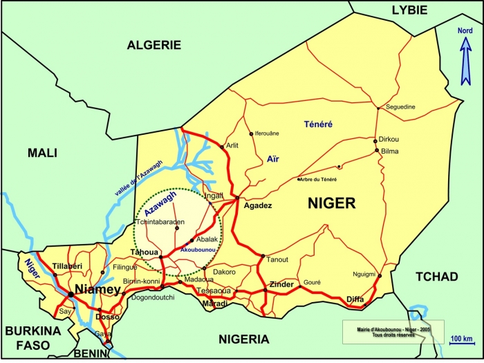
    But now the C.I.A. is broadening its drone operations, moving aircraft to northeastern Niger to hunt Islamist militants in southern Libya. The expansion adds to the agency’s limited covert missions in eastern Afghanistan for strikes in Pakistan, and in southern Saudi Arabia for attacks in Yemen.

    Nigerien and American officials said the C.I.A. had been flying drones on surveillance missions for several months from a corner of a small commercial airport in Dirkou. Satellite imagery shows that the airport has grown significantly since February to include a new taxiway, walls and security posts.

    One American official said the drones had not yet been used in lethal missions, but would almost certainly be in the near future, given the growing threat in southern Libya. The official spoke on the condition of anonymity to discuss the secretive operations.

    A C.I.A. spokesman, Timothy Barrett, declined to comment. A Defense Department spokeswoman, Maj. Sheryll Klinkel, said the military had maintained a base at the Dirkou airfield for several months but did not fly drone missions from there.

    The drones take off from Dirkou at night — typically between 10 p.m. and 4 a.m. — buzzing in the clear, starlit desert sky. A New York Times reporter saw the gray aircraft — about the size of Predator drones, which are 27 feet long — flying at least three times over six days in early August. Unlike small passenger planes that land occasionally at the airport, the drones have no blinking lights signaling their presence.

    “All I know is they’re American,” Niger’s interior minister, Mohamed Bazoum, said in an interview. He offered few other details about the drones.

    Dirkou’s mayor, Boubakar Jerome, said the drones had helped improve the town’s security. “It’s always good. If people see things like that, they’ll be scared,” Mr. Jerome said.

    Mr. Obama had curtailed the C.I.A.’s lethal role by limiting its drone flights, notably in Yemen. Some strikes in Pakistan and elsewhere that accidentally killed civilians, stirring outrage among foreign diplomats and military officials, were shielded because of the C.I.A.’s secrecy.

    As part of the shift, the Pentagon was given the unambiguous lead for such operations. The move sought, in part, to end an often awkward charade in which the United States would not concede its responsibility for strikes that were abundantly covered by news organizations and tallied by watchdog groups. However, the C.I.A. program was not fully shut down worldwide, as the agency and its supporters in Congress balked.

    The drone policy was changed last year, after Mike Pompeo, the C.I.A. director at the time, made a forceful case to President Trump that the agency’s broader counterterrorism efforts were being needlessly constrained. The Dirkou base was already up and running by the time Mr. Pompeo stepped down as head of the C.I.A. in April to become Mr. Trump’s secretary of state.

    The Pentagon’s Africa Command has carried out five drone strikes against Qaeda and Islamic State militants in Libya this year, including one two weeks ago. The military launches its MQ-9 Reaper drones from bases in Sicily and in Niamey, Niger’s capital, 800 miles southwest of Dirkou.

    But the C.I.A. base is hundreds of miles closer to southwestern Libya, a notorious haven for Al Qaeda and other extremist groups that also operate in the Sahel region of Niger, Chad, Mali and Algeria. It is also closer to southern Libya than a new $110 million drone base in Agadez, Niger, 350 miles west of Dirkou, where the Pentagon plans to operate armed Reaper drone missions by early next year.

    Another American official said the C.I.A. began setting up the base in January to improve surveillance of the region, partly in response to an ambush last fall in another part of Niger that killed four American troops. The Dirkou airfield was labeled a United States Air Force base as a cover, said the official, who spoke on the condition of anonymity to discuss confidential operational matters.

    The C.I.A. operation in Dirkou is burdened by few, if any, of the political sensitivities that the United States military confronts at its locations, said one former American official involved with the project.

    Even so, security analysts said, it is not clear why the United States needs both military and C.I.A. drone operations in the same general vicinity to combat insurgents in Libya. France also flies Reaper drones from Niamey, but only on unarmed reconnaissance missions.

    “I would be surprised that the C.I.A. would open its own base,” said Bill Roggio, editor of the Foundation for Defense of Democracies’ Long War Journal, which tracks military strikes against militant groups.

    Despite American denials, a Nigerien security official said he had concluded that the C.I.A. launched an armed drone from the Dirkou base to strike a target in Ubari, in southern Libya, on July 25. The Nigerien security official spoke on the condition of anonymity to discuss the classified program.

    A spokesman for the Africa Command, Maj. Karl Wiest, said the military did not carry out the Ubari strike.

    #Ubari is in the same region where the American military in March launched its first-ever drone attack against Qaeda militants in southern Libya. It is at the intersection of the powerful criminal and jihadist currents that have washed across Libya in recent years. Roughly equidistant from Libya’s borders with Niger, Chad and Algeria, the area’s seminomadic residents are heavily involved in the smuggling of weapons, drugs and migrants through the lawless deserts of southern Libya.

    Some of the residents have allied with Islamist militias, including Al Qaeda in the Islamic Maghreb, which operates across Algeria, Mali, Niger and Libya.

    Dirkou, in northeast Niger, is an oasis town of a few thousand people in the open desert, bordered by a small mountain range. For centuries, it has been a key transit point for travelers crossing the Sahara. It helped facilitate the rise of Islam in West Africa in the 9th century, and welcomed salt caravans from the neighboring town of Bilma.

    The town has a handful of narrow, sandy roads. Small trees dot the horizon. Date and neem trees line the streets, providing shelter for people escaping the oppressive midday heat. There is a small market, where goods for sale include spaghetti imported from Libya. Gasoline is also imported from Libya and is cheaper than elsewhere in the country.

    The drones based in Dirkou are loud, and their humming and buzzing drowns out the bleats of goats and crows of roosters.

    “It stops me from sleeping,” said Ajimi Koddo, 45, a former migrant smuggler. “They need to go. They go in our village, and it annoys us too much.”

    Satellite imagery shows that construction started in February on a new compound at the Dirkou airstrip. Since then, the facility has been extended to include a larger paved taxiway and a clamshell tent connected to the airstrip — all features that are consistent with the deployment of small aircraft, possibly drones.

    Five defensive positions were set up around the airport, and there appear to be new security gates and checkpoints both to the compound and the broader airport.

    It’s not the first time that Washington has eyed with interest Dirkou’s tiny base. In the late 1980s, the United States spent $3.2 million renovating the airstrip in an effort to bolster Niger’s government against Col. Muammar el-Qaddafi, then the leader of Libya.

    Compared with other parts of Africa, the C.I.A.’s presence in the continent’s northwest is relatively light, according to a former State Department official who served in the region. In this part of Niger, the C.I.A. is also providing training and sharing intelligence, according to a Nigerien military intelligence document reviewed by The Times.

    The Nigerien security official said about a dozen American Green Berets were stationed earlier this year in #Dirkou — in a base separate from the C.I.A.’s — to train a special counterterrorism battalion of local forces. Those trainers left about three months ago, the official said.

    It is unlikely that they will return anytime soon. The Pentagon is considering withdrawing nearly all American commandos from Niger in the wake of the deadly October ambush that killed four United States soldiers.

    https://www.nytimes.com/2018/09/09/world/africa/cia-drones-africa-military.html
    #CIA #drones #Niger #Sahel #USA #Etats-Unis #EI #ISIS #Etat_islamique #sécurité #terrorisme #base_militaire

    • Le Sahel est-il une zone de #non-droit ?

      La CIA a posé ses valises dans la bande sahélo-saharienne. Le New-York Times l’a annoncé, le 9 septembre dernier. Le quotidien US, a révélé l’existence d’une #base_de_drones secrète non loin de la commune de Dirkou, dans le nord-est du Niger. Cette localité, enclavée, la première grande ville la plus proche est Agadez située à 570 km, est le terrain de tir parfait. Elle est éloignée de tous les regards, y compris des autres forces armées étrangères : France, Allemagne, Italie, présentes sur le sol nigérien. Selon un responsable américain anonyme interrogé par ce journal, les drones déployés à Dirkou n’avaient « pas encore été utilisés dans des missions meurtrières, mais qu’ils le seraient certainement dans un proche avenir, compte tenu de la menace croissante qui pèse sur le sud de la Libye. » Or, d’après les renseignements recueillis par l’IVERIS, ces assertions sont fausses, la CIA a déjà mené des opérations à partir de cette base. Ces informations apportent un nouvel éclairage et expliquent le refus catégorique et systématique de l’administration américaine de placer la force conjointe du G5 Sahel (Tchad, Mauritanie, Burkina-Faso, Niger, Mali) sous le chapitre VII de la charte des Nations Unies.
      L’installation d’une base de drones n’est pas une bonne nouvelle pour les peuples du Sahel, et plus largement de l’Afrique de l’Ouest, qui pourraient connaître les mêmes malheurs que les Afghans et les Pakistanais confrontés à la guerre des drones avec sa cohorte de victimes civiles, appelées pudiquement « dégâts collatéraux ».

      D’après le journaliste du NYT, qui s’est rendu sur place, les drones présents à Dirkou ressembleraient à des Predator, des aéronefs d’ancienne génération qui ont un rayon d’action de 1250 km. Il serait assez étonnant que l’agence de Langley soit équipée de vieux modèles alors que l’US Air Force dispose à Niamey et bientôt à Agadez des derniers modèles MQ-9 Reaper, qui, eux, volent sur une distance de 1850 km. A partir de cette base, la CIA dispose donc d’un terrain de tir étendu qui va de la Libye, au sud de l’Algérie, en passant par le Tchad, jusqu’au centre du Mali, au Nord du Burkina et du Nigéria…

      Selon deux sources militaires de pays d’Afrique de l’Ouest, ces drones ont déjà réalisé des frappes à partir de la base de Dirkou. Ces bombardements ont eu lieu en Libye. Il paraît important de préciser que le chaos existant dans ce pays depuis la guerre de 2011, ne rend pas ces frappes plus légales. Par ailleurs, ces mêmes sources suspectent la CIA d’utiliser Dirkou comme une prison secrète « si des drones peuvent se poser des avions aussi. Rien ne les empêche de transporter des terroristes de Libye exfiltrés. Dirkou un Guantanamo bis ? »

      En outre, il n’est pas impossible que ces drones tueurs aient été en action dans d’autres Etats limitrophes. Qui peut le savoir ? « Cette base est irrégulière, illégale, la CIA peut faire absolument tout ce qu’elle veut là-bas » rapporte un officier. De plus, comment faire la différence entre un MQ-9 Reaper de la CIA ou encore un de l’US Air Force, qui, elle, a obtenu l’autorisation d’armer ses drones (1). Encore que…

      En novembre 2017, le président Mahamadou Issoufou a autorisé les drones de l’US Air Force basés à Niamey, à frapper leurs cibles sur le territoire nigérien (2). Mais pour que cet agrément soit légal, il aurait fallu qu’il soit présenté devant le parlement, ce qui n’a pas été le cas. Même s’il l’avait été, d’une part, il le serait seulement pour l’armée US et pas pour la CIA, d’autre part, il ne serait valable que sur le sol nigérien et pas sur les territoires des pays voisins…

      Pour rappel, cette autorisation a été accordée à peine un mois après les événements de Tongo Tongo, où neuf militaires avaient été tués, cinq soldats nigériens et quatre américains. Cette autorisation est souvent présentée comme la conséquence de cette attaque. Or, les pourparlers ont eu lieu bien avant. En effet, l’AFRICOM a planifié la construction de la base de drone d’Agadez, la seconde la plus importante de l’US Air Force en Afrique après Djibouti, dès 2016, sous le mandat de Barack Obama. Une nouvelle preuve que la politique africaine du Pentagone n’a pas changée avec l’arrivée de Donald Trump (3-4-5).

      Les USA seuls maîtres à bord dans le Sahel

      Dès lors, le véto catégorique des Etats-Unis de placer la force G5 Sahel sous chapitre VII se comprend mieux. Il s’agit de mener une guerre non-officielle sans mandat international des Nations-Unies et sans se soucier du droit international. Ce n’était donc pas utile qu’Emmanuel Macron, fer de lance du G5, force qui aurait permis à l’opération Barkhane de sortir du bourbier dans lequel elle se trouve, plaide à de nombreuses reprises cette cause auprès de Donald Trump. Tous les présidents du G5 Sahel s’y sont essayés également, en vain. Ils ont fini par comprendre, quatre chefs d’Etats ont boudé la dernière Assemblée générale des Nations Unies. Seul, le Président malien, Ibrahim Boubacar Keïta, est monté à la tribune pour réitérer la demande de mise sous chapitre VII, unique solution pour que cette force obtienne un financement pérenne. Alors qu’en décembre 2017, Emmanuel Macron y croyait encore dur comme fer et exigeait des victoires au premier semestre 2018, faute de budget, le G5 Sahel n’est toujours pas opérationnel ! (6-7) Néanmoins, la Chine a promis de le soutenir financièrement. Magnanime, le secrétaire d’Etat à la défense, Jim Mattis a lui assuré à son homologue, Florence Parly, que les Etats-Unis apporteraient à la force conjointe une aide très significativement augmentée. Mais toujours pas de chapitre VII en vue... Ainsi, l’administration Trump joue coup double. Non seulement elle ne s’embarrasse pas avec le Conseil de Sécurité et le droit international mais sous couvert de lutte antiterroriste, elle incruste ses bottes dans ce qui est, (ce qui fut ?), la zone d’influence française.

      Far West

      Cerise sur le gâteau, en août dernier le patron de l’AFRICOM, le général Thomas D. Waldhauser, a annoncé une réduction drastique de ses troupes en Afrique (9). Les sociétés militaires privées, dont celle d’Erik Prince, anciennement Blackwater, ont bien compris le message et sont dans les starting-blocks prêtes à s’installer au Sahel (10).


      https://www.iveris.eu/list/notes_danalyse/371-le_sahel_estil_une_zone_de_nondroit__

  • How mapmakers help indigenous people defend their lands
    https://www.nationalgeographic.com/culture-exploration/2018/10/indigenous-cultures-mapping-projects-reclaim-lands-columbus

    One early project in the 1990s focused on the remote Darién region of Panama. Official maps of the area contained little detail—the persistent cloud cover and dense rainforest canopy were impenetrable to the satellite imagery and aerial photos that government cartographers used to make their maps. But to the three main indigenous groups in the region, Emberá, the Wounaan, and the Guna, the land was filled with landmarks.

    The organization’s approach was simple: ask indigenous people to draw detailed maps of their lands, and then get professional cartographers to incorporate this information into modern, geographically accurate maps.

    To map the Darién, indigenous leaders selected men from communities in the region to act as surveyors. The surveyors then set out by bus, by canoe, or on foot, armed with pencils, pens, and blank sheets of manila paper to sketch the local waterways and other landmarks. In collaboration with villagers and their leaders they carefully drew maps that included things of importance to their communities that wouldn’t typically appear on government maps, like hunting and fishing grounds, or places where firewood, fruit, or medicine were gathered. They often chose to leave out cemeteries and sacred sites, preferring to keep that knowledge within their communities. The quality of these maps varies considerably, but the best of them are works of art, Chapin says (see below).

    #cartographie #cartographie_participative #territoire #peuples_autochtones

  • Maps Mania : Norway’s Secret Military Sites
    https://googlemapsmania.blogspot.com/2018/09/norways-secret-military-sites.html

    Norway has released an interactive map of all the military locations where it is forbidden to operate a drone and some security experts are not happy. All the markers on the Innmelding av Sensorflygning map indicates an area where it is illegal to take aerial photographs or video using a camera or any other type of sensors.

    The map shows many of Norway’s most secret military installations, such as Norway’s secret war headquarters and the location of one of Europe’s two transmitters for communicating with NATO’s submarine fleet. The map also shows the location of 237 other important military and security locations. Some military and security experts have been shocked by the map’s release. For example former Chief of Maritime Safety and Naval Home Guard Commander Svein Jarle Jacobsen said that the map is “disastrous for operational safety. I can’t believe that they’ve really done this.”

    The Deputy Director of NSM, (Norway’s National Security Authority) Frode Skaarnes, has dismissed claims that the map reveals the country’s military secrets. He claims that the map shows nothing that cannot already be viewed on any map with aerial or satellite imagery and that the map “doe not say anything about what exactly is there and what these facilities are used for.”

  • Anatomy of a Killing - BBC News

    Voici une recherche (Forensic research) très impressionnante sur cette histoire horrible : La démarche devrait beaucoup intéresser @simplicissimus et peut-être pourrions nous reparler et débattre de ce que le BBC a réussi à faire ici. Je reste sans voix.

    https://www.youtube.com/watch?v=4G9S-eoLgX4

    In July 2018 a horrifying video began to circulate on social media. It shows two women and two young children being led away at gunpoint by a group of Cameroonian soldiers. The captives are blindfolded, forced to the ground, and shot 22 times.

    #cameroun #nigéria #meurtres #boko_haram

    • These women and children while being led to their deaths the soldiers accused them of belonging to the jihadist group Boko Haram graphic tissue here they’re blindfolded posted the ground and shot a close-range 22 * one of the women still has the baby strapped to her back the video began to circulate on my 10th 2018 some claimed that this atrocity took place in Molly where government soldiers have been fighting Boko Haram since 2014 the government of Cameroon initially dismissed the video as fake news a month later they announce the seven members of the military wear under investigation but there has still been no official admission that these killings were carried out in cameroonian song by government soldiers and there is still no guarantee that anyone will be held to account so how can we tell what really happened here over the next few minutes we’re going to follow these women and children on the short walk to the end of their lives and to glean from this video the clues that tell us where this happened when it happened and who was responsible for this atrocity this looks like the kind of Dusty anonymously track that could be anywhere in the Sahel what the first 40 seconds of the film capture a mountain range with the distinctive profile we spent hours trying to match this rage to the Topography of Northern Cameroon and then in Late July we received a tip-off from a cameroonian sourced have you looked at the area near Santa Fe close to the town of side of it we found a match for the Ridgeline it this is the scene on a dirt road just outside of Village called crime Alpha a few hundred meters away is the border with Nigeria the video also reveals other details that can be matched precisely to what we see on the satellite imagery this track these buildings and these trees putting all this evidence together we can say with certainty but the killings took place here less than a kilometer away instead of it we found this compound and identify this the combat Outpost used by the cameroonian military and their fight against Boko Haram will come back to this base later exactly when the killings took place at First Sight harder to say but again the video contains Clues this building is visible and satellite imagery but only until February 2016 the murders must have happened before that date satellite images also captured this structure the Wolves surrounding it I’ll present an imagery dated March 2015 but it not yet been built in November 2014 giving earliest possible date for the atrocity the video also reveals this footpath a part that only appears in the hot dry season between January and April less obvious clues in the video as they leave these women away the soldiers like moving sundials cost Shadows on the track a simple mathematical formula tells us the end the sun in comparison to the Horizon we can also see what direction the light is coming from when we add this data to our location we can get a precise time frame for this event The Killing between March 20th and April 5th 2015 we now know where this happened and we know when it happened but who are the men who murdered these women and children in July is Serta Roma Bakery cameroon’s minister of communication insisted that the killers are not cameroonian soldiers and presented what he claimed was irrefutable evidence from the video itself the weapons he said I’m not those used by the cameroonian Army in this area of operation but your analysis shows that one of these is a Serbian made the stopper M21 it’s rare in sub-Saharan Africa but it is used by some divisions of the cameroonian military also claimed that a close examination of the shoes the soldiers wearing colorful Forrestal camouflage in the phone knows he said cameroonian soldiers wear pale desert style fatigues a closer look at the evidence reveals this cancel just seen here in a 2015 report by Channel 4 News filmed inside of it wearing darker forestal fatigues similar to those seen in the video on Facebook we also found these pictures cameroonian soldiers wearing the same type of camouflage the images attack to CertiFit but carry also question why the soldiers are not wearing the standard combat gear of troops stationed in that area be helmets bulletproof vest and ranges boots Beyonce is that the soldiers when those house on patrol they would just a few hundred metres away from the combat Outpost we saw earlier we know that this is a military base because we match the features visible in satellite imagery to the details in the channel 4 news report that was short hair in 2015 new movies this year and I Misty International investigators spoke with residents who have been displaced by the fighting to a nearby Town among them was the man who said that sold these women and children being brought into the base by cameroonian soldiers a short while after they will either way he said he heard gunfire in August there was a sudden change in the government Fishing Off 2 weeks of denying that these killings took place in Cameroon vicari announced that seven members of the cameroonian military had been arrested and we’re under investigation or analysis has and avoid three men who actually pulled the trigger one of them is this man introduced at the start of the film as chocho that links the nickname chocho to a soldier called Syriac patiala is among the detainees named by the government the BBC has also spoken with a former cameroonian Soldier to confirm but this is chocho cyriak patiala at the end of the film we see him again blindfolding the little girl he’s about to kill a few seconds later he draw his weapon and opens fire analysis Identify two other guns that were used in The Killing one of them was in the hands of this man we see him here blindfolding the woman with the baby seconds before the shooting starts resource identified him as Barnabas go no so we would not able to confirm this identification a very similar name Barnabas Donna Sue appeared 11 days later on the government’s List of soldiers under investigation the 3rd weapon used in The Killing is the Zastava M21 we saw earlier it is in the hands of a man introduced in the video as second-class cobra so who is Cobra of the women and children are killed Cobra is the lost man still firing into the body’s one of his colleagues calls out tangle leave it there dead when he still does not stop shooting the cold out again that’s enough tanker that’s enough the name Sanger also appears list of men under investigation suggesting but Cobra is a nickname for Lance corporal Tanga another man named among those arrested is Etienne Sebastian he’s the platoon commander who was interviewed by channel 4 news in 2015 as far as week until he does not appear in the video we put these findings to the government of Cameroon who responded Honda investigation right now until the investigation has been concluded and that hold of them will be given a fair trial new due process was extended to the two women killed outside set of it and no presumption of innocence was a foot to the children who died with them
      In July 2018 a horrifying video began to circulate on social media. It shows two women and two young children being led away at gunpoint by a group of Cameroonian soldiers. The captives are blindfolded, forced to the ground, and shot 22 times.

      The government of Cameroon initially dismissed the video as “fake news.” But BBC Africa Eye, through forensic analysis of the footage, can prove exactly where this happened, when it happened, and who is responsible for the killings.

      Warning: this video contains disturbing content

      Investigation by Aliaume Leroy and Ben Strick.
      Produced by Daniel Adamson and Aliaume Leroy.
      Motion Graphics: Tom Flannery

      Please subscribe HERE http://bit.ly/1rbfUog

    • (je commente ici…)

      Intéressant (et horrible !) La localisation par la ligne de crête me laisse très dubitatif. Elle me semble habiller une localisation obtenue par des moyens plus … classiques ; peut-être pour protéger une source.

      En particulier, la suite de la vidéo montre que les enquêteurs ont eu accès directement sur place, par exemple lors du reportage sur le poste militaire, à diverses informations, notamment l’identité des participants.

      Le recoupement entre images et vues par satellite interviennent plus comme confirmation ou pour préciser la localisation des séquences : les constructions sont vraiment sommaires et elles manquent totalement d’éléments remarquables. Sans localisation globale, rien de tout cela n’est utilisable.

  • Classifying #drivers of #global_forest_loss | Science
    http://science.sciencemag.org/content/361/6407/1108/tab-figures-data

    #Mapping global #deforestation patterns
    Forest loss is being driven by various factors, including commodity production, forestry, agriculture, wildfire, and urbanization. Curtis et al. used high-resolution Google Earth imagery to map and classify global forest loss since 2001. Just over a quarter of global forest loss is due to deforestation through permanent land use change for the production of commodities, including beef, soy, palm oil, and wood fiber. Despite regional differences and efforts by governments, conservationists, and corporations to stem the losses, the overall rate of commodity-driven deforestation has not declined since 2001.

    Abstract
    Global maps of forest loss depict the scale and magnitude of forest disturbance, yet companies, governments, and nongovernmental organizations need to distinguish permanent conversion (i.e., deforestation) from temporary loss from forestry or wildfire. Using satellite imagery, we developed a forest loss classification model to determine a spatial attribution of forest disturbance to the dominant drivers of land cover and land use change over the period 2001 to 2015. Our results indicate that 27% of global forest loss can be attributed to deforestation through permanent land use change for commodity production. The remaining areas maintained the same land use over 15 years; in those areas, loss was attributed to forestry (26%), shifting agriculture (24%), and wildfire (23%). Despite corporate commitments, the rate of commodity-driven deforestation has not declined. To end deforestation, companies must eliminate 5 million hectares of conversion from supply chains each year.

    http://science.sciencemag.org/content/sci/361/6407/1108/F2.large.jpg?width=800&height=600&carousel=1

  • A Turning Point in Tropical Forest Monitoring – Planet Stories – Medium
    https://medium.com/planet-stories/a-turning-point-in-tropical-forest-monitoring-f7b693f69417

    Brazil was among the first countries to pioneer the use of satellite imagery to track annual land use change. However, these initiatives have been constrained by a lack of frequent, high-resolution data — making it difficult to segment different land use classes or detect degradation early enough to intervene.

    This could soon change.

    Recent improvements in the spatial and temporal resolution of satellite imagery by Planet and the availability of machine learning and imagery analysis at global scale by #Google offer new opportunities to disrupt historical limitations.

    #Brésil #forêt #déforestation #images_satellite

  • Earth’s intact forests vanishing at accelerating pace: scientists (Update)
    https://phys.org/news/2018-06-loss-earth-intact-forests-scientists.html

    Earth’s intact forests shrank by an area larger than Austria every year from 2014 to 2016 at a 20 percent faster rate than during the previous decade, scientists said Wednesday as the UN unveiled an initiative to harness the “untapped potential” of the land sector to fight climate change.

    Despite a decades-long effort to halt deforestation, nearly 10 percent of undisturbed forests have been fragmented, degraded or simply chopped down since 2000, according to the analysis of satellite imagery.

    Average daily loss over the first 17 years of this century was more than 200 square kilometres (75 square miles).

    “Degradation of intact forest represents a global tragedy, as we are systematically destroying a crucial foundation of climate stability,” said Frances Seymour, a senior distinguished fellow at the World Resources Institute (WRI), and a contributor to the research, presented this week at a conference in Oxford.

    “Forests are the only safe, natural, proven and affordable infrastructure we have for capturing and storing carbon.”

    #forêt #déforestation

  • ANALYSIS-Data-bait: using tech to hook globe’s multi-billion-dollar fishing cheats
    https://af.reuters.com/article/africaTech/idAFL8N1Q94J5

    In 2016, a Thai-flagged fishing vessel was detained in Seychelles on suspicion that it had been fishing illegally in the Indian Ocean, one of the world’s richest fishing grounds.

    The Jin Shyang Yih 668 was caught with help from technology deployed by FISH-i Africa, a grouping of eight east African countries including Tanzania, Mozambique and Kenya.

    But as the vessel headed to Thailand, which pledged to investigate and prosecute the case, it turned off its tracking equipment and disappeared. Its whereabouts remain unknown.

    Such activity is rampant in the global fishing industry, experts say, where illegal, unreported and unregulated (IUU) fishing is estimated to cost $23.5 billion a year.

    However, a range of non-profit and for-profit organisations that are developing technology solutions to tackle IUU say it is a matter of time before vessels can no longer vanish.

    The industry is developing very fast ... basically the oceans will be fully traceable. There is no place to hide,” said Roberto Mielgo Bregazzi, the co-founder of Madrid-based FishSpektrum, one of the few for-profit platforms.

    With backing from Google, Microsoft’s Paul Allen and Leonardo DiCaprio, among others, such platforms also track fishing on the high seas and in marine reserves, aided by radio and satellite data that send vessels’ locations and movements.

    They use satellite imagery, drones, algorithms and the ability to process vast amounts of data, as well as old-fashioned sleuthing and analysis, to help countries control their waters.

    Algorithms could identify illegal behaviour, Mielgo Bregazzi told the Thomson Reuters Foundation, including predicting when a fishing vessel was about to meet its quota, triggering an alarm.

    Bradley Soule, the chief fisheries analyst at OceanMind, a non-profit, said technology can help even rich countries, which might otherwise struggle to process the volume of data broadcast by hundreds of thousands of vessels.

    Organisations such as his crunch that data and help to differentiate between normal and suspicious activity.

    The bulk of the threat is non-compliance by mainly legal operators who skirt the rules when they think no one’s looking,” said Soule, who helps Costa Rica monitor its waters.
    […]
    Dirk Zeller, who heads the Sea Around Us - Indian Ocean project at the University of Western Australia, said as the ocean’s bounty is a public resource, the world should know who is taking what.

    Part of the problem, he said, is overcapacity in the global fishing fleet.

    But he also points to difficulties in calculating IUU’s scale: the FAO’s estimates of fish stocks, for instance, are based on official government data, which are open to under- and over-reporting.

    His research shows global catches from 1950 to 2010 were 50 percent higher than countries had said.
    […]
    The FAO’s senior fishery officer, Matthew Camilleri, agrees technology is no silver bullet.

    “What use is it if you’re able to detect IUU fishing and find the vessel with illegal fish on board, but you do not have the process in place to enforce, to prosecute?” he said.

    Progress is underway towards that in the form of the FAO’s 2009 Port State Measures Agreement, which is aimed at curbing IUU fishing. Close to half of the 194 U.N. member states have signed it, including four of the top five fishing nations - Indonesia, the United States, Russia and Japan.

    China, though, has not. It is the world’s largest fishing nation, whose 2014 catch of 14.8 million tons, the FAO’s 2016 State of the World’s Fisheries report showed, was as much as the next three nations combined.

    When asked whether it was likely to sign, China’s mission to the FAO in Rome told the Thomson Reuters Foundation it was not authorized to comment.

    Tony Long from GFW - which runs a free-to-access platform that uses Automatic Identification System (AIS) data to track the global movement of vessels - said combining technology with cooperation between countries could close the loopholes.

  • #Turkmenistan seeks to tap into East-West cargo flows with new seaport | Agricultural Commodities | Reuters
    https://af.reuters.com/article/commoditiesNews/idAFL8N1S92X2

    Turkmenistan on Wednesday opened a new $1.5 billion cargo and passenger seaport on the Caspian Sea aiming to boost its export revenues by handling shipping traffic between Asia and Europe.

    The Central Asian country’s main source of hard currency is its gas exports, which took a hit when Russia, once its main customer, stopped all purchases in 2016 after a pricing dispute.

    The port, in the city of #Turkmenbashi, will more than triple Turkmenistan’s cargo handling capacity to 25-26 million tonnes a year, the government has said.

    Speaking before the official opening ceremony, Turkmen President Kurbanguly Berdymukhamedov said Ashgabat was ready to discuss the use of the seaport with its landlocked neighbours, a reference to Uzbekistan and Afghanistan.

    Turkmenistan already has a railway link with China through neighbouring Kazakhstan and the new port could help Ashgabat win a slice of cargo flows moving between China, the Middle East and Europe. Russia, Azerbaijan, Kazakhstan and Iran also have Caspian ports.

    The new port also has container handling facilities and a polypropylene terminal which will handle products from a nearby plant which is set to be launched later this year.

    Turkmenistan does not report how much cargo its existing Caspian port currently handles.

    #Caspienne

  • Interview with #Forensic_Architecture Founder #Eyal_Weizman | 2018-05-01 | Architectural Record
    https://www.architecturalrecord.com/articles/13367-interview-with-forensic-architecture-founder-eyal-weizman

    Born in Israel and educated at the Architectural Association (AA), Eyal Weizman could be considered more a detective than an architect. In 2011, Weizman established Forensic Architecture, an agency based at the Centre for Research Architecture at Goldsmiths, University of London. He directs the center. The group, whose funders include the European Research Council, combs through data such as smartphone footage, satellite imagery, maps, and phone logs to create three-dimensional spatial maps of conflict sites, using architectural rendering software and other analytic tools. Significant projects have included full-scale replicas of key elements of Auschwitz gas chambers and incinerators for an exhibit at the 2016 Venice Architecture Biennale, and an investigation into the U.S. bombing of a Syrian mosque last year. The firm, which was just shortlisted for the Turner Prize, is currently scrutinizing the deadly blaze at London’s Grenfell Tower in June 2017, mining publicly available footage to create a 3-D model that will serve as an open resource for people to better understand the events that led to the fire. Weizman spoke to RECORD from the group’s office at Goldsmiths.

  • Blaming the Rescuers
    https://blamingtherescuers.org/iuventa
    https://www.youtube.com/watch?v=3CQaj2KNIZw

    In our report we analysed and countered the arguments used to fuel a “toxic narrative” against rescue NGOs, which emanated from EU agencies such as Frontex and different institutional bodies in Italy. While this campaign had remained largely on a discursive level, over the summer of 2017 it quickly escalated with the Italian government’s attempt to impose a “code of conduct” on rescue NGOs. An intense standoff ensued as several NGOs, from larger organisations such as Doctors without Borders to smaller ones such as the German Jugend Rettet (‘Youth Rescue’), refused to sign it before the announced deadline of 31 July 2017, claiming that the code would have threatened their activities at sea with requests that a leading legal scholar had described as “nonsensical”, “dishonest” and “illegal”.

    On 2 August 2017, only days after this deadline had passed, Jugend Rettet’s ship, the Iuventa, was seized by the Italian judiciary. Its crew was accused of having colluded with smugglers during three different rescue operations: the first on the 10 September 2016, the second and third on 18 June 2017. The order of seizure contended that on those occasions the Iuventa was being used to “aiding and abetting illegal immigration” by arranging the direct handover of migrants by smugglers and returning empty boats for re-use.

    The video presented here offers a counter-investigation of the authorities’ version, and a refutation of their accusations.

    • Forensic Oceanography – visibleproject
      http://www.visibleproject.org/blog/project/forensic-oceanography-various-locations-in-europe-and-northern-afric

      Forensic Oceanography (FO) is a project that critically investigates the militarised border regime in the Mediterranean Sea, analysing the spatial and aesthetic conditions that have caused over 16,500 registered deaths at the maritime borders of Europe over the last 20 years. Together with a wide network of NGOs, scientists, journalists and activist groups, FO has produced, since 2011, several maps, video animations (e.g. Liquid Traces), visualisations, human rights reports (e.g. the report on the ‘Left-to-Die Boat’ case) and websites (e.g. www.watchthemed.net) that attempt to document the violence perpetrated against migrants at sea and challenge the regime of visibility imposed by surveillance means on this contested area.

      By combining testimonies of human rights violations with digital technologies such as satellite imagery, vessel tracking data, geo-spatial mapping and drift modelling, FO has exercised a critical right to look at sea with a two-fold purpose. On the one hand, using surveillance means ‘against the grain’, it has produced spatial analysis that has been used within existing legal and political forums, supporting the quest for justice of migrants and their families in legal proceedings, parliamentary auditions, human rights and journalistic investigations. At the same time, through a series of installations and articles, FO has attempted to spur a debate on the politics of image production in the age of surveillance and on what it means to produce images, videos and sounds that become evidence and documentation of human rights violations.

    • Bonjour @unagi !
      Super de mettre en avant le travail de Lorenzo Pezzani e Charles Heller...
      Toutefois, je voulais te rendre attentif du fait que les vidéos que tu as postés relèvent de différentes enquêtes faites par les deux chercheurs...

      Celle-ci :
      https://www.youtube.com/watch?v=3CQaj2KNIZw


      fait partie d’une « trilogie » pour prouver qu’il n’y a pas collusion entre les ONG et les trafiquants. C’est leur dernier travail.
      Voici où trouver tous les documents y relatifs :
      http://www.forensic-architecture.org/case/iuventa

      Pour les autres, il y a pas mal de documentation sur seenthis.

    • Non, sorry @unagi c’est moi qui me suis trompée...

      En fait ils ont utilisé le site blamingtherescuers (ton premier lien) aussi pour y mettre leur dernière analyse, celle de la #Iuventa.
      Je me suis trompée car « Blaming the rescuers » a été aussi le titre d’un de leurs rapports...
      #sorry

  • North Korea’s Yongbyon Nuclear Research Center: Major Activity at the Five Megawatt Reactor.
    https://www.38north.org/2018/04/yongbyon040418

    Commercial satellite imagery from March 30 indicates that North Korea may have shut down the 5 MWe (plutonium production) reactor for the time being. A major excavation project has also begun near the cooling water outfall, which, when coupled with recent efforts to dam the river below this point to create a reservoir, could indicate an attempt to provide a more steady flow of water into the facility. This would allow for the reactor to run more continuously and safely in the future.

    There is also new truck activity at the reactor, the purpose of which is unclear but could include maintenance or repairs, the movement of spent fuel rods to the Radiochemical Laboratory from the spent fuel storage pond, or the offloading of fresh fuel to the reactor. Despite the apparent reactor shutdown, there was no evidence (as of March 30) of plutonium reprocessing taking place at the Radiochemical Laboratory. However, this development should be monitored closely in the future.

    At the Experimental Light Water Reactor (ELWR), work continues on an adjacent building that may be a laboratory or for engineering support, but there are no obvious signs that the reactor is approaching operational status.

  • Myanmar builds military bases on the site of Rohingya homes and mosques – report | World news | The Guardian
    https://www.theguardian.com/world/2018/mar/12/myanmar-builds-military-bases-on-the-site-of-rohingya-homes-and-mosques

    Myanmar’s military is building bases where Rohingya homes and mosques once stood, Amnesty International said on Monday, citing new evidence from satellite imagery.

    Nearly 700,000 members of the Muslim minority fled to Bangladesh in 2017 after Myanmar launched a brutal crackdown on insurgents that the US and UN have called ethnic cleansing. Myanmar rejects that accusation, saying it was responding to attacks by the Arakan #Rohingya Salvation Army in late August.

    #birmanie

  • Peatland mappers win $1m to help tackle Indonesian haze ...
    http://news.trust.org/item/20180202095105-978cz

    An award-winning method for mapping Indonesia’s vast peatlands, developed by Dutch, German and Indonesian scientists, will help the Southeast Asian nation tackle annual fires that harm health in the region, the organisers of the prize said on Friday.

    The International Peat Mapping Team (IPMT) will receive $1 million for winning the two-year competition, funded by the David and Lucile Packard Foundation and managed by the U.S.-based World Resources Institute (WRI).

    “To be able to manage peat well, we needed to have a map, and the map we had before was not that comprehensive,” said Nirarta Samadhi, director of WRI Indonesia.

    Indonesian government agencies, which helped organise the competition, will start using the new methodology as soon as possible, said Supiandi Sabiham, co-chair of the judges.

    The IPMT’s approach, which combines satellite imagery, LiDAR technologies and on-the-ground measurement, won for its accuracy, speed and affordability, added Sabiham.

    Peat soils contain huge quantities of carbon in the form of organic matter, which accumulates over thousands of years and provides nutrients for plant growth.

    http://www.indonesianpeatprize.net

    #tourbières #Indonésie #cartographie

  • Center for International Earth Science Information Network
    http://www.ciesin.columbia.edu/data/hrsl

    The High Resolution Settlement Layer (HRSL) provides estimates of human population distribution at a resolution of 1 arc-second (approximately 30m) for the year 2015. The population estimates are based on recent census data and high-resolution (0.5m) satellite imagery from DigitalGlobe. The population grids provide detailed delineation of settlements in both urban and rural areas, which is useful for many research areas—from disaster response and humanitarian planning to the development of communications infrastructure. The settlement extent data were developed by the Connectivity Lab at Facebook using computer vision techniques to classify blocks of optical satellite data as settled (containing buildings) or not. CIESIN used proportional allocation to distribute population data from subnational census data to the settlement extents. The population data have been developed for 18 countries: Algeria, Burkina Faso, Cambodia, Ghana, Haiti, Ivory Coast, Kenya, Madagascar, Malawi, Mexico, Mozambique, the Philippines, Puerto Rico, Rwanda, South Africa, Sri Lanka, Tanzania, Thailand, and Uganda. Read more about the project here.

    ici une image de Cape Town :

    #population #urban_matter #datasource #cartographie

  • The Angry Arab News Service/وكالة أنباء العربي الغاضب: The UN Secretary-general: who does he work for?
    http://angryarab.blogspot.com/2017/11/the-un-secretary-general-who-does-he.html

    #Guterres said in the report to the U.N. Security Council circulated Friday that allegations of arms transfers to Hezbollah continue “on a regular basis,” which the U.N. takes seriously. But it “is not in a position to substantiate them independently , he said. Guterres said #Israel informed UNIFIL of the alleged presence of Hezbollah weapons and infrastructure in three specific locations in that zone, which the U.N. force closely monitored, including by aerial reconnaissance, satellite imagery and patrols. But he said” no evidence to confirm the allegations was established .” (thanks Basim)

    http://abcnews.go.com/US/wireStory/chief-warns-risk-israeli-hezbollah-conflict-51369567

    #ONU

  • Hundreds of Mysterious Stone ‘Gates’ Found in Saudi Arabia’s Desert - The New York Times
    https://www.nytimes.com/2017/10/19/science/saudi-arabia-gates-google-earth.html

    Google Earth has unlocked the gates to ancient mysteries around the world.

    For years, amateur and professional archaeologists have used the search engine’s satellite imagery to discover mysterious earthworks in Kazakhstan, Roman ruins, a forgotten fortress in Afghanistan and more. In the past decade, Google Earth also has helped identify thousands of burial sites and other “works of the old men,” as they’re called, scattered across Saudi Arabia.

    Now, archaeologists have uncovered nearly 400 previously undocumented stone structures they call “gates” in the Arabian desert that they believe may have been built by nomadic tribes thousands of years ago.

    We tend to think of Saudi Arabia as desert, but in practice there’s a huge archaeological treasure trove out there and it needs to be identified and mapped,” said David Kennedy, an archaeologist at the University of Western Australia and author of a paper set to appear in the November issue of the journal Arabian Archaeology and Epigraphy.

    You can’t see them very well from the ground level, but once you get up a few hundred feet, or with a satellite even higher, they stand out beautifully.


    Ground views of Samhah Gate 31. Scientists are not sure what purpose these structures served.
    Credit Grant Scroggie