
The Hidden Meanings of Maps (1/2) | Pick-Me-Up Tonic
▻https://pickmeuptonic.wordpress.com/2013/10/18/the-hidden-meanings-of-maps
Intéressante analyse, j’ai eu la surprise d’y trouver une de mes production de 1993 - 25 ans tout de même... - en exemple dans le corps du texte
 https://pickmeuptonic.files.wordpress.com/2013/10/belgique-3.png?w=700&h=548
 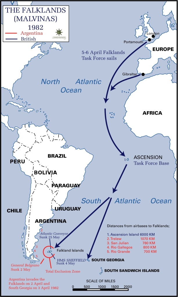 https://pickmeuptonic.files.wordpress.com/2013/10/falklands_campaign_distances_to_bases_1982.jpg?w=613&h=1024
 2. Scale matters
Once you’ve picked up a projection, you have to choose what scale is the best to illustrate the trend or phenomena you want to show. More than a zoom level, picking up the right scale is a tricky & meaningful process similar to building a photograph composition.
The scale choice reveals the very interpretation the cartographer is making of the represented phenomena. People and places that do not appear on the map are considered not relevant to the topic. Then, the edges of the map define a time & space frame containing both the issue & its solution/explanation.
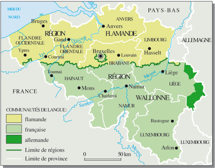
belgique-3
On this map from Le Monde Diplomatique, for instance, the political situation in Belgium is the topic. The map was illustrating an article about the 1993 agreement of Saint Michel that made Belgium a federal state by unifying the two main regions as well as smaller german regions under the same government. This is a very specific debate concerning Belgium and Belgium only, not depending on external forces. The issue (political unity of Belgium) contains its solution (its a national debate that no one else can solve but Belgians).
On the example below, a map illustrating the Falklands War of 1982 between United Kingdom and Argentina over Falklands Islands sovereignty, the playground is the Atlantic Ocean, North to South.
Falklands,Campaign,(Distances_to_bases)_1982
The map focuses on the two protagonists to show how & when they moved strategically to an actual open conflict over the Falklands. There is clearly no other country involved in this, nor other political influences. The map is focusing on strategy, events timeline and show very well the obvious handicap of distance United Kingdom had. That tells us a lot about how UK’s empire last bite was escaping from its yoke and how they desperately fought for it, more as a symbol than as an essential land possession.