

The evolution of land uses and population in #Psyrri district
The Psyrri district is one of the oldest districts of Athens. It is bounded by the streets of Evripidou, Athinas, Ermou, Agion Asomaton, Pireos (PanagiTsaldari) and, despite its limited surface, has changed in recent years, to reflect typical transformations that exist in the wider center of Athens (Καιροφύλας 2000).
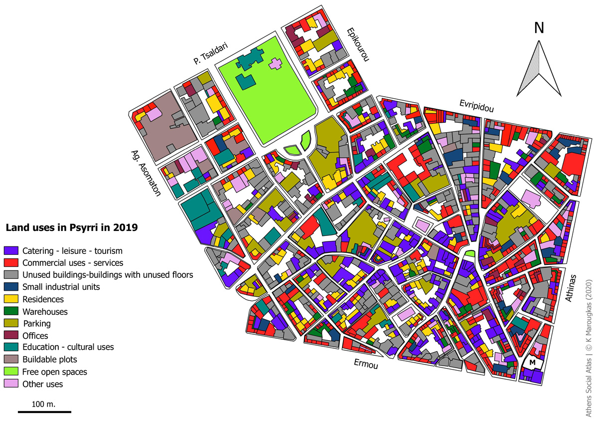
In this text, we track the spatial and social transformations which took place in the Psyrri district via a comparison of land use maps drawn in 1996 and 2019. The land uses maps of 1996 are based on a study by Attiko Metro while the corresponding maps of 2019, are based on fieldwork by the author. During the fieldwork, the uses of ground floors, upper floors, as well as the buildable open spaces were mapped separately, to give a complete picture of the area’s land uses.
The basemap for 1996, was designed with QGIS software, exactly as it was depicted in the map of Attiko Metro.
At the same time, the cartographic background for the 2019 map, was provided by ELSTAT and was edited using QGIS software to show the ground floor and upper floor uses, separately. In particular, the outlines of the buildings were redesigned and their ground floors and upper floors were labelled. The ELSTAT basemap was drawn in 2001[1], so, in some cases, the building boundary lines had to be redrawn in order to bring the map up to date.
From the first visit to the neighborhood of Psyrri, it became clear, that the area’s land use profile has changed significantly. Comparing the area’s land use maps of 1996 and 2019, one observes the changes that have occurred over a period of 23 years. These changes have significantly altered the district’s character
 https://www.athenssocialatlas.gr/wp-content/uploads/2020/08/tx144_m2_en.jpg
  https://www.athenssocialatlas.gr/wp-content/uploads/2020/07/tx144_p4.gif
 ▻https://www.athenssocialatlas.gr/en/article/psyrri-district
#Athènes #démographie #cartographie #visualisation
