Asteroid Mining - Most Valuable and Profitable Asteroids Ranking - Asterank
▻http://www.asterank.com/exoplanets
Asteroid Mining - Most Valuable and Profitable Asteroids Ranking - Asterank
▻http://www.asterank.com/exoplanets

DADA / DATA / RMC
▻http://dada-data.net/fr/rmc
A chacun son Ready Made ! Tous les jours, jusqu’au 5 mars 2016, courrez la chance de recevoir chez vous un objet DADA imprimé en #3D et en direct depuis le Cabaret Voltaire, Zurich. Entrez dans le tchat, inscrivez-vous, racontez votre choix, soufflez vos attentes, et scrutez votre objet en train de s’imprimer.

3D Paper Model of Shrinking Aral Sea
▻https://petervojtek.github.io/diy/2015/07/14/aral-sea.html
During the last 60 years Aral Sea has almost completely dryed up. This shrinking is considered to be “one of the planet’s worst environmental disasters”.
I took the surface outlines of Aral Sea from past 60 years and combined them together into a single 3D paper cube:


Et le créateur de ceci cite cela :) —>


Music and Sound Vibrations 3D Printed Into Ceramic Vessels | Colossal
▻http://www.thisiscolossal.com/2016/02/music-and-sound-vibrations-3d-printed-into-ceramic-vessels/?mc_cid=e4de5e61d8&mc_eid=a53b581529
The project, “Solid Vibration” was produced by spatial sound designer Ricky van Broekhoven and designer Olivier van Herpt, who have been co-producing the objects that appear almost like woven baskets

#three.js - documentation - Manual - Creating a scene
▻http://threejs.org/docs/#Manual/Introduction/Creating_a_scene
Three.js is a library that makes #webGL - #3D in the browser - easy to use. While a simple cube in raw WebGL would turn out hundreds of lines of Javascript and shader code, a Three.js equivalent is only a fraction of that.

Suisse Mania
▻http://www.suissemania.ch/explore

@fil ça mériterait un seen à part, non ?

Berlins neue Skyline
Wie die Innenstadt seit 1990 gewachsen ist – und wie sie in Zukunft aussehen soll. Eine Entdeckungstour in #3D.
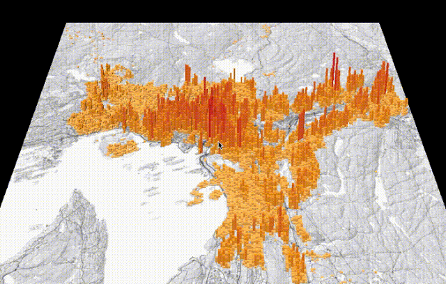
Mapping grid-based statistics using OpenLayers, Three.js and D3.js
▻http://blog.thematicmapping.org/2015/11/mapping-grid-based-statistics-with.html
#cartographie #3D #D3.js #three.js — et le code est pas du tout monstrueux
#BMW i8 - PLAYCANVAS
▻http://playcanv.as/p/RqJJ9oU9?overlay=false
Tags : #WebGL #3D BMW #configurateur #clevermarks
Fractal Fantasy
▻http://fractalfantasy.net/#/4/uncanny_valley
Tags : #3D #visage #WebGL #démo #clevermarks
#webgl Fundamentals
▻http://webglfundamentals.org
Un ensemble de leçons pour aborder le WebGL
#canvas #javascript #3D #tutoriel #cours
100yrs of Data Visualisation best practice — Mapping with balsa wood. Just like the New York...
▻http://100yrsofbrinton.tumblr.com/post/99067461631/mapping-with-balsa-wood-just-like-the-new-york
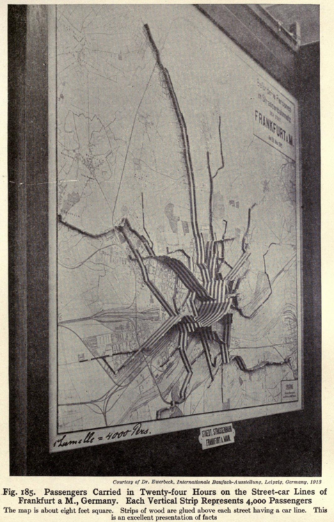 https://31.media.tumblr.com/a31fd01ddfb51763132125c891eee4df/tumblr_inline_ncte9pZvOg1sr3w0m.png
  http://31.media.tumblr.com/0be719b213a4dcdc26af43ba5d2261cc/tumblr_inline_nctev6tTo51sr3w0m.png
 It’s not easy to show passenger numbers on a transit network. But in 1914 all you need to do is use wood, as above, or strips of metal!
This same technique has been used by the New York Times in their excellent look at the evolution of neighbourhoods along the route of the NY marathon.

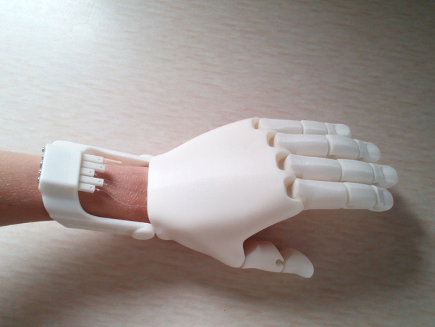
Download this hand
#open_source
The Flexy Hand and Flexy Hand 2 | Enabling The Future
▻http://enablingthefuture.org/upper-limb-prosthetics/the-flexy-hand
Flexy-Hand by Gyrobot - Thingiverse
▻http://www.thingiverse.com/thing:242639/#instructions

Introducing #3d #tiles
▻http://cesiumjs.org/2015/08/10/Introducing-3D-Tiles
3D Tiles are an open specification for streaming massive heterogeneous 3D geospatial datasets. To expand on Cesium’s terrain and imagery streaming, 3D Tiles will be used to stream 3D content, including buildings, trees, point clouds, and vector data.
#map
#cesiumjs pour faire le lien avec ▻http://seenthis.net/messages/461876
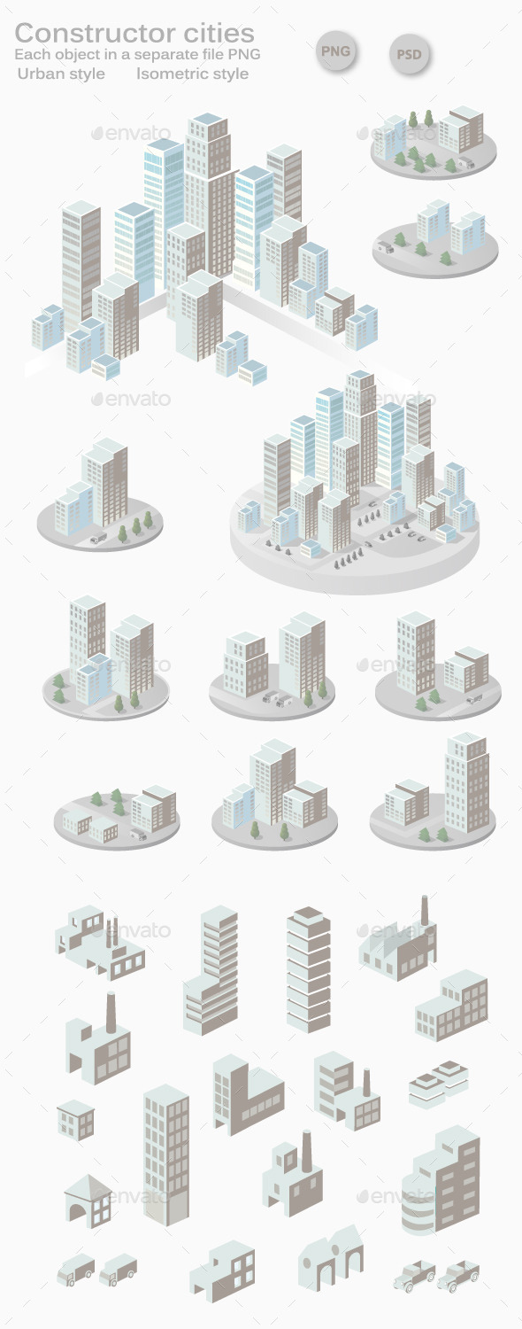
Constructor cities | GraphicRiver
▻http://graphicriver.net/item/constructor-cities/11592161?ref=berlinsau&ref=berlinsau&clickthrough_id=446099542&redirec
Payant mais pas cher et sans doute assez marrant
#3D #ville #agglomération #représentation_graphique #illustration #infographie
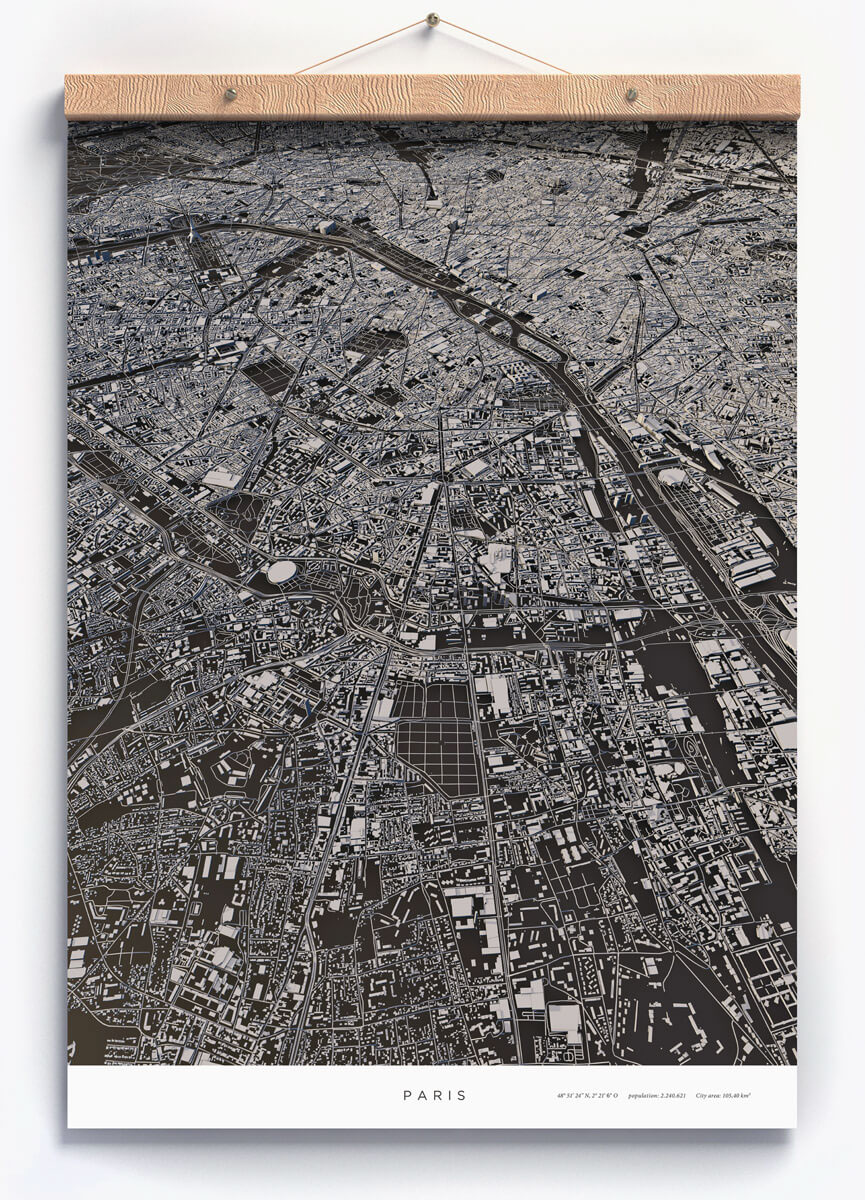
City Layouts on Behance
►https://www.behance.net/gallery/24276859/City-Layouts
Topography, architecture and traffic routes give every city a unique structure.
These conditions create the typical and individual inner structure of a city.
I didn’t only want to show these structures in the conventional way from above, but also including the exact three-dimensionality of topography and buildings - a real world visualisation.
The OpenStreetMap data enabled me to visualize the satellite-based information using DEM Earth in Cinema 4D. The results are some extraordinary views of large capitals and small towns.
Series of gallery quality art prints for sale on Society6
Specific cities or perspectives are available on request.
How we created an immersive Street Walk Experience with a GoPro and Javascript — Medium
▻https://medium.com/@tibbb/how-we-created-an-immersive-street-walk-experience-with-a-gopro-and-javascri
(juste génial)
#cartographie #visualisation #3D #immersion #making-of #vidéo_interactive
City Layouts on Behance
►https://www.behance.net/gallery/24276859/City-Layouts
▻https://m1.behance.net/project_cover?proj_id=24276859&size=404
Topography, architecture and traffic routes give every city a unique structure.
These conditions create the typical and individual inner structure of a city.
I didn’t only want to show these structures in the conventional way from above, but also including the exact three-dimensionality of topography and buildings - a real world visualisation.
The OpenStreetMap data enabled me to visualize the satellite-based information using DEM Earth in Cinema 4D. The results are some extraordinary views of large capitals and small towns.
Series of gallery quality art prints for sale on Society6
Specific cities or perspectives are available on request.
#cartographie #3D #osm

Borneo’s rainforest may get high-tech #3D scan to boost conservation
▻http://news.mongabay.com/2015/0504-cao3-forest-monitoring-platform-launch.html
On Friday, the Carnegie Institution officially unveiled the latest upgrade of the Carnegie Airborne Observatory, an airplane equipped with technologies that enable scientists to conduct extremely high resolution scans of forest structure, biomass, and biological diversity. The platform has generated a wealth of information in places where it has been flown before, including surveying tree diversity across the Amazon, measuring forest carbon stocks in Panama and Madagascar, identifying critical wildlife habitats in Colombia, revealing massive tree die-offs in remote areas in Peru, mapping invasive plant species in Hawaii, and documenting previously unknown lion behavior in South Africa.
But the new plane is even better, according to Greg Asner, who conceived of and led development of the plane’s systems. The overhaul has doubled the plane’s sensing range and greatly expanded its capacity to collect and analyze data.
“The system produces maps that tell us more about an ecosystem in a single airborne overpass than what might be achieved in a lifetime of work on the ground. Our improved onboard computing, software integration, data capture, navigation, and ergonomics would make any #Silicon_Valley tech nerd drool,” wrote Asner in a blog post announcing the new plane. “Flight operations are streamlined and can be rapidly mobilized from California to anywhere on Earth.”
The carbon mapping process. In Peru, #CAO was used to measure deforestation and degradation by establishing a baseline for free Landsat imagery and forest cover monitoring software like as CLASlite, which was also developed by Asner’s team at Carnegie.
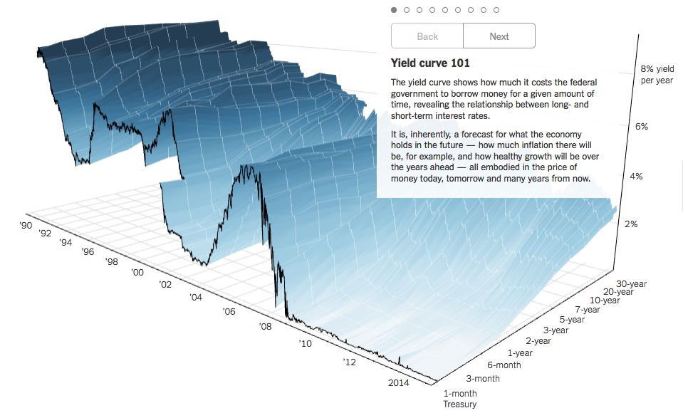
A 3-D View of a Chart That Predicts The Economic Future : The Yield Curve - NYTimes.com
▻http://www.nytimes.com/interactive/2015/03/19/upshot/3d-yield-curve-economic-growth.html
le NYT continue d’innover avec ses #visualisations graphiques interactives ; ça reste assez ardu, mais c’est le sujet qui veut ça
kekscom/L.Line3
▻https://github.com/kekscom/L.Line3
L.Line3 is #leaflet map layer for drawing #3d vector lines.
Example ▻http://keks.com/dev/line3

Résultat étrange et surprenant avec ce #geojson des remparts de Brest :
DIY : Construire une mini imprimante 3D pour moins de 50€ grâce à vos déchets électroniques
▻http://www.additiverse.com/actualites/2014-11-08/diy-construire-une-mini-imprimante-3d-pour-moins-de-50
Le blogueur Mikelllc a partagé un tutoriel sur le site Instructables.com pour vous aider à construire, avec un tout petit budget, votre propre imprimante 3D à partir de composants électroniques recyclés. Il vous en coûtera moins de 50€ et c’est un excellent moyen d’en apprendre plus sur les bases de la technologie d’impression 3D et comment fonctionne une imprimante réellement.
▻http://www.instructables.com/id/eWaste-60-3DPrinter/?ALLSTEPS

Je sais pas trop quoi en penser, des imprimantes 3d. Y a un truc qui me chiffone en termes d’#outil_convivial et de #contre-productivité
Oui j’ai un peu le même sentiment, mais aussi une intuition que ça peut servir de générateur de pièces spécifiques qui pourraient servir à réparer des objets, à faire du sur mesure sans prix prohibitif, ou pour faire de nouvelles choses (comme des nouvelles pièces pour une micro-irrigation) mais j’arrive pas à mettre le doigt dessus encore


The Dawn Wall
Tommy Caldwell and Kevin Jorgeson etched their names into climbing lore on Wednesday by successfully completing a 19-day free-climb of the Dawn Wall on El Capitan. The route up the mostly smooth granite face is widely considered to be the most difficult free-climb in the world. A free-climb means that ropes are used only to catch a climber’s fall — not to aid the ascent.