Space in Images - 2018 - 05 - Antarctica in 3D
▻http://www.esa.int/spaceinimages/Images/2018/05/Antarctica_in_3D
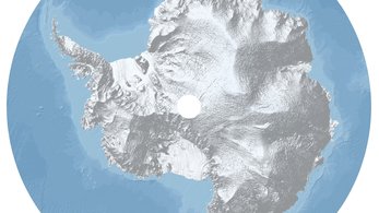
ça m’attriste un peu ce trou au milieu, mais c’est le #DEM le plus précis qui soit de l’#Antarctique
Space in Images - 2018 - 05 - Antarctica in 3D
▻http://www.esa.int/spaceinimages/Images/2018/05/Antarctica_in_3D
ça m’attriste un peu ce trou au milieu, mais c’est le #DEM le plus précis qui soit de l’#Antarctique

Orange snow creates eerie post-Apocalyptic scenes in eastern Europe | Toronto Star
▻https://www.thestar.com/news/world/2018/03/26/orange-snow-creates-eerie-post-apocalyptic-scenes-in-eastern-europe.html
The photos and videos haven’t been edited by the latest Instagram filter or otherwise digitally manipulated. Orange-tinted snow did blanket parts of Eastern Europe on Friday and over the weekend, creating eerie post-Apocalyptic scenes and baffling people from countries like Russia, Bulgaria, Ukraine, Romania and Moldova, the BBC reported.
Documentation of the strange snow appeared all over social media, with some making jokes about “skiing on Mars,” according to CNN.
While orange snow seems unearthly, meteorologists said the phenomenon actually occurs about every five years and that this instance was caused by sand from storms in the Sahara Desert mixing with snow and rain, according to the BBC.
Unlike past occurrences, however, the concentrations of sand are much higher this time, with people even complaining of getting it in their mouths, the BBC reported.
Un coup des Libyens…
Space in Images - 2018 - 03 - Turning snow orange
▻http://www.esa.int/spaceinimages/Images/2018/03/Turning_snow_orange
Sand and dust stirred up by desert storms in north Africa have caused snow in eastern Europe to turn orange, transforming mountainous regions into Mars-like landscapes.
This Copernicus Sentinel-2A image of Libya captured on 22 March shows Saharan dust being blown northwards across the Mediterranean Sea. Lifted into the atmosphere, the dust was carried by the wind and pulled back down to the surface in rain and snow. It reached as far afield as Greece, Romania, Bulgaria and Russia. While the orange-tinted snow baffled skiers, meteorologists say this phenomenon occurs about every five years.
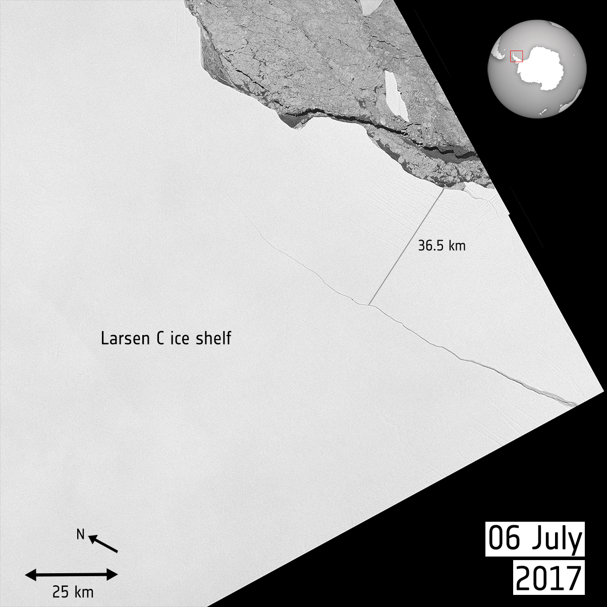
Space in Images - 2017 - 09 - Giant berg on the move
▻http://www.esa.int/spaceinimages/Images/2017/09/Giant_berg_on_the_move
Witnessed by the Copernicus Sentinel-1 mission on 12 July 2017, a lump of ice more than twice the size of Luxembourg broke off the Larsen C ice shelf, spawning one of the largest icebergs on record and changing the outline of the Antarctic Peninsula forever. Over the following two months, systematic observations from Sentinel-1 showed that the A68 berg remained close, buffeting back and forth against the ice shelf. It was unclear what would happen to the berg because they can remain in one place for years.
However, the mission has revealed that A68 is now on the move and drifting out to sea. Images from 16 September show that there is a gap of about 18 km as the berg appears to be turning away from the shelf.
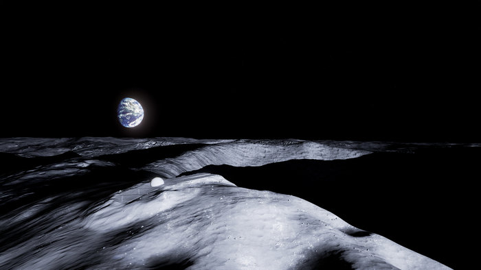
Space in Images - 2017 - 01 - Temple atop Shackleton Crater
▻http://www.esa.int/spaceinimages/Images/2017/01/Temple_atop_Shackleton_Crater
A near-perpetually sunlit peak close to the Moon’s south pole has been selected by ESA’s artist-in-residence as the site of a building like no other.
Artist Jorge Mañes Rubio, part of ESA’s future-oriented Advanced Concepts Team (ACT), has designed a place of contemplation to serve a future lunar settlement. It would be built on the sunlit rim of Shackleton Crater, which is bathed much of the time in sunlight while overlooking a 4.2 km-deep interior mired in perpetual shadow.
Hélas, je n’ai pas trouvé le lien pour le crowdfunding.
Space in Images - 2017 - 01 - Caravan on ice
▻http://www.esa.int/spaceinimages/Images/2017/01/Caravan_on_ice
How do you deliver supplies to one of the remotest research stations on Earth? Put the equipment and food on skis and pull them by tractor across the ice and snow in a long caravan.
This image was taken by France’s Pleiades satellite orbiting 700 km high. The convoy of supplies can be seen on the 1000 km trek from Dumont d’Urville on the Antarctic coast to Concordia research station.
Et pour ceux qui voudraient pouvoir suivre au plus près du terrain, je recommande chaudement la BD
Futuropolis >> Fiche titre : La Lune est blanche
▻http://www.futuropolis.fr/fiche_titre.php?id_article=790354
La Lune est blanche, François et Emmanuel Lepage, Futuropolis, 2014
« L’Antarctique. Le sixième continent. 14 millions de kilomètres carrés. Un dôme de glace enchâssé dans un socle rocheux. Le continent le plus sec, le plus froid, le plus difficile d’accès. Le continent des superlatifs. Le monde des extrêmes. »
En 2011, Yves Frenot, directeur de l’Institut polaire français, invite Emmanuel Lepage et son frère François, photographe, à intégrer une mission scientifique sur la base française antarctique Dumont d’Urville, en Terre-Adélie. Le but ? Réaliser un livre qui témoignerait du travail des savants. Yves Frenot leur propose, en outre, de participer, comme chauffeurs, au raid de ravitaillement de la station Concordia, située au coeur du continent de glace à 1 200 km de Dumont d’Urvillle.
Le Raid, comme on l’appelle, c’est LA grande aventure polaire ! Pour les deux frères, ce serait l’aventure de leur vie, mais rien ne se passera comme prévu !


@simplicissimus j’avais aussi adoré cette BD ▻https://freakonometrics.hypotheses.org/18314 (et puis j’ai découvert celle sur Tchernobyl qui m’a scotché presque encore plus...)
Tout à fait d’accord, mais j’ai lu dans l’ordre (de parution, disons) donc celle sur Tchernobyl est un peu plus lointaine dans mon souvenir. Mais elle laisse une impression d’ensemble extrêmement forte.
Un printemps à Tchernobyl, Emmanuel Lepage, 2012, Futuropolis
▻http://www.futuropolis.fr/fiche_titre.php?id_article=790222
26 avril 1986. À Tchernobyl, le coeur du réacteur de la centrale nucléaire commence à fondre. Un nuage chargé de radionucléides parcourt des milliers de kilomètres. Sans que personne ne le sache… et ne s’en protège. C’est la plus grande catastrophe nucléaire du XXe siècle. Qui fera des dizaines de milliers de victimes. À cette époque, Emmanuel Lepage a 19 ans. Il regarde et écoute, incrédule, les informations à la télévision.
22 ans plus tard, en avril 2008, il se rend à Tchernobyl pour rendre compte, par le texte et le dessin, de la vie des survivants et de leurs enfants sur des terres hautement contaminées. Quand il décide de partir là-bas, à la demande de l’association les Dessin’acteurs, Emmanuel a le sentiment de défier la mort.
Quand il se retrouve dans le train qui le mène en Ukraine, où est située l’ancienne centrale, une question taraude son esprit : que suis-je venir faire ici ?

Haaa Lepage, perso je l’ai découvert avec « Voyage aux îles de la Désolation », qui m’a donné envie de lire tous ceux que vous venez de citer :)
▻http://www.futuropolis.fr/fiche_titre.php?id_article=790085
Youhou, Lepage va bientôt publier une bd sur le phare Ar-Men !
▻http://www.letelegramme.fr/soir/bd-emmanuel-lepage-dans-les-entrailles-d-armen-14-09-2017-11663514.php
Space in Images - 2017 - 01 - Global colour mosaic of Dione
▻http://www.esa.int/spaceinimages/Images/2017/01/Global_colour_mosaic_of_Dione
Meet Dione, a 1122 km-diameter icy satellite of Saturn and the 15th largest moon in the Solar System.
This global colour mosaic of the moon’s intriguing surface was produced from images taken by the international Cassini spacecraft during its first 10 years of exploring the Saturn system.
Perhaps the most striking observation is the difference in colour and brightness between the left and right halves of the image. They correspond to the ‘trailing’ and ‘leading’ hemispheres respectively, in terms of the direction that the moon is travelling along its orbit around Saturn every 2.7 days.
The dark coating on the trailing hemisphere is thought to be due to radiation from Saturn’s magnetosphere, which causes organic elements in the moon’s surface to become darker and redder in appearance.
The wispy white streaks that wind through the coloured surface are bright ice cliffs – some several hundred metres high – resulting from tectonic fractures.
Meanwhile the leading hemisphere has been painted with icy dust from Saturn’s E-ring, which itself is fed by tiny particles ejected from nearby moon Enceladus.
[…]
This global mosaic was first released in 2014. The image resolution is 250 m per pixel.
Space in Images - 2016 - 08 - Italy earthquake displacement
▻http://www.esa.int/spaceinimages/Images/2016/08/Italy_earthquake_displacement
Combining two Sentinel-1 radar scans from 20 August (Sentinel-1B) and 26 August 2016 (Sentinel-1A), this interferogram shows changes that occurred during the 24 August earthquake that struck central Italy.
The seven interferometric ‘fringes’ correspond to about 20 cm of surface deformation in the radar sensor line of sight. Each fringe (which is associated to a colour cycle) corresponds to approximately 2.8 cm of displacement.
Although Sentinel-1 has a swath width of 250 km over land surfaces, its pass over Italy on 26 August did not cover the entire area affected. Another acquisition planned for 27 August will cover the entire earthquake zone.
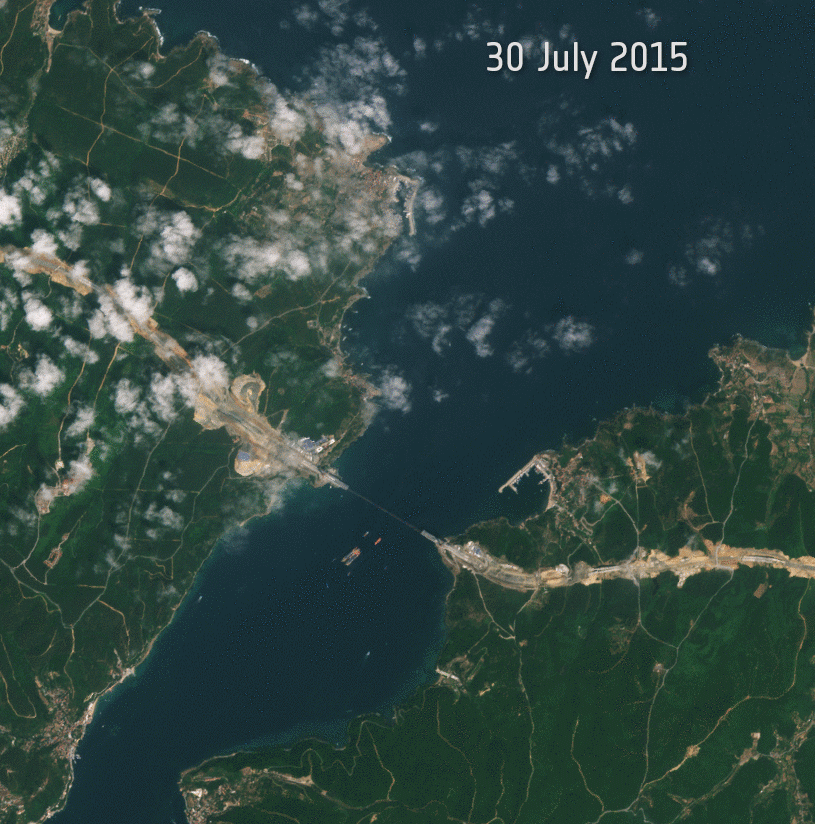
Space in Images - 2016 - 08 - Third Bosphorus Bridge progress
▻http://www.esa.int/spaceinimages/Images/2016/08/Third_Bosphorus_Bridge_progress
These 17 images from the Sentinel-2A satellite show a year of progress on the Third Bosphorus Bridge in Istanbul, Turkey.
Also known as the Yavuz Sultan Selim Bridge, the hybrid cable-stayed suspension bridge forms part of the ongoing 150 km-long Northern Marmara Highway project. With eight lanes of motorway and two rail lines, its 322 m A-shaped towers stand taller than the Eiffel Tower.
The Third Bosphorus Bridge opened on 26 August 2016.

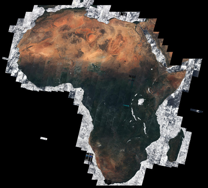
African mosaic
▻http://www.esa.int/spaceinimages/Images/2016/05/African_mosaic
Using almost 7000 images captured by the Sentinel-2A satellite, this mosaic offers a cloud-free view of the African continent – about 20% of the total land area in the world. The majority of these separate images were taken between December 2015 and April 2016, totalling 32 TB of data. Thanks to Sentinel-2A’s 290 km-wide swath and 10-day revisit at the equator, the chance of imaging Earth’s surface when the skies are clear is relatively high. Nevertheless, being able to capture the Tropics cloud-free over the five months is remarkable.
Presented at the recent Living Planet Symposium in Prague, Czech Republic, this is the first mosaic of Africa generated through ESA’s Climate Change Initiative Land Cover project.
Root-zone soil moisture May 2016
Space in Images - 2016 - 05 - Root-zone soil moisture May 2016
▻http://www.esa.int/spaceinimages/Images/2016/05/Root-zone_soil_moisture_May_2016
ESA’s SMOS mission was launched in 2009 to provide global observations of soil moisture and ocean salinity – two important variables in Earth’s water cycle. While this novel Earth Explorer satellite continues to advance our understanding of the planet, it is also showing considerable potential for real-world applications to improve everyday life. A number of these applications have been presented at the Living Planet Symposium in Prague in the Czech Republic. One example demonstrates how information from SMOS is being used to help forecast crop yield and to monitor drought.
With a growing population, the issue of food security is of global concern. Agricultural management and global food security can be more effective if crop yield is estimated accurately. Root-zone soil moisture data are now being used by the US Department of Agriculture in their crop-yield forecasting system.
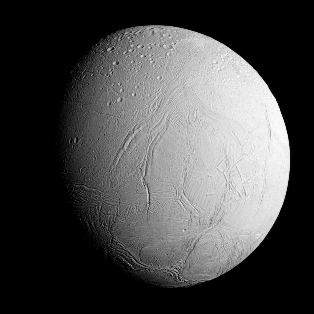
Space in Images - 2015 - 11 - Sampling the ocean on Enceladus
▻http://www.esa.int/spaceinimages/Images/2015/11/Sampling_the_ocean_on_Enceladus
The Cassini spacecraft captured this view of Saturn’s icy moon Enceladus as it approached for its closest-ever flyby of the moon’s active south polar region.
The spacecraft flew about 49 km above the surface through the towering plumes of ice, water vapour and organic molecules spraying from that region. Previous flybys have sampled the plume but the low altitude of this close encounter was devised partly to provide greater sensitivity to heavier, more massive molecules, including organics.
Studies with Cassini have shown that beneath the moon’s icy exterior lies a global ocean heated in part by tidal forces from Saturn and its moon Dione.
Scientists will use the new information gathered during this dive through the plume to gain insights about how habitable the ocean environment may be for simple forms of life, and to study the chemistry and composition of the plume.
In this view of the moon, the heavily cratered northern latitudes at the top transition to fractured, wrinkled terrain in the middle and southern latitudes. The wavy boundary of the moon’s active south polar region – Cassini’s destination for this flyby – is visible at the bottom, where it disappears into wintry darkness.
This image of the Saturn-facing side of the moon was taken with the narrow-angle camera on 28 October 2015 when Cassini was at a distance of some 96 000 km from Enceladus. The image scale is 578 m per pixel.
sur le site du JPL
▻http://photojournal.jpl.nasa.gov/catalog/PIA17202
Space in Images - 2015 - 07 - Station Moon transit
▻http://www.esa.int/spaceinimages/Images/2015/07/Station_Moon_transit
This image of the Moon was taken by amateur photographer Dylan O’Donnell as the International Space Station passed by at 28 800 km/h. At such speeds the weightless research laboratory was visible for only about a third of a second before returning to the dark skies.
Dylan captured the moment in Byron Bay, New South Wales, the eastern-most point of Australia, where the absence of larger towns offers low levels of light pollution.
The image was taken on 30 June 2015 at 19:54 local time with the Space Station flying 400 km above the Pacific Ocean. A conventional camera was placed behind a 2300 mm / f10 telescope and Dylan took as many pictures as possible during the Station’s brief passage and hoped for the best.
Five images of the Moon taken before and after the Station passed by were processed using freely available astrophotography tools to improve sharpness, a process called stacking. Lastly, the colours were enhanced to bring out the Moon’s colourful surface geology.
Photo d’amateur… éclairé !

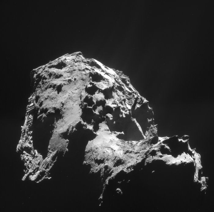
Closest picture of #67P yet - 0.74 meters per pixel, released on 16/02
▻http://www.esa.int/spaceinimages/Images/2015/Comet_on_14_February_from_8.7_km #ESA
Space in Images - 2015 - 01 - Snowy Pyrenees seen by Proba-V
▻http://www.esa.int/spaceinimages/Images/2015/01/Snowy_Pyrenees_seen_by_Proba-V
In this Proba-V image, acquired on 1 January 2015, the southern part of France with the snow-capped Pyrenees Mountains is shown.
In the upper part of the image a persistent cloud field in the Garonne Valley is visible. The image resolution is 300 metres.
Proba-V is a miniaturised ESA satellite tasked with a full-scale mission: to map land cover and vegetation growth across the entire planet every two days.
Space in Images - 2015 - 01 - New view of the Pillars of Creation - infrared
▻http://www.esa.int/spaceinimages/Images/2015/01/New_view_of_the_Pillars_of_Creation_-_infrared
The NASA/ESA Hubble Space Telescope has revisited one of its most iconic and popular images: the Eagle Nebula’s Pillars of Creation.
This image shows the pillars as seen in infrared light, allowing it to pierce through obscuring dust and gas and unveil a more unfamiliar – but just as amazing – view of the pillars.
In this ethereal view the entire frame is peppered with bright stars and baby stars are revealed being formed within the pillars themselves. The ghostly outlines of the pillars seem much more delicate, and are silhouetted against an eerie blue haze.

Happy New Year!
▻http://blogs.esa.int/rosetta/2015/01/06/happy-new-year
We’re back! After a pause over the festive period to recharge our batteries (hoping that Philae will soon do the same), the #Rosetta blog has now reopened for business. Welcome back to all of you! Before we preview the exciting year ahead for Rosetta, we’d like to kindly remind you of some blog house rules: Please keep all comments relevant to the blog post that you’re commenting on (repeated posting of similarly themed and irrelevant comments on multiple posts will be considered as spamming or trolling and will be trashed). Please use respectful language when responding to other comments. If you disagree with something, that’s fine, but any comments that are considered aggressive or unnecessarily rude will not be published. Constructive criticism is welcome! While speculation of what you (...)
Sur le site de l’ESA, mais pas sur le blog Rosetta, ce superbe montage de 4 images prises le 1er janvier

Space in Images - 2014 - 11 - OSIRIS spots Philae drifting across the comet
▻http://www.esa.int/spaceinimages/Images/2014/11/OSIRIS_spots_Philae_drifting_across_the_comet
These incredible images show the breathtaking journey of Rosetta’s Philae lander as it approached and then rebounded from its first touchdown on Comet 67P/Churyumov–Gerasimenko on 12 November 2014.
The mosaic comprises a series of images captured by Rosetta’s OSIRIS camera over a 30 minute period spanning the first touchdown. The time of each of image is marked on the corresponding insets and is in GMT. A comparison of the touchdown area shortly before and after first contact with the surface is also provided.

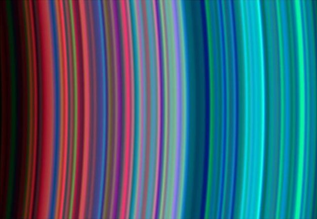
Space in Images - 2014 - 05 - Saturn’s rainbow rings
▻http://www.esa.int/spaceinimages/Images/2014/05/Saturn_s_rainbow_rings
Raffa
Space in Images - 2014 - 05 - Saturn’s rainbow rings - ►http://www.esa.int/spacein...
2 minutes ago
from Bookmarklet
Comment
Like